Showing 1290 items
matching lands
-
 Bendigo Historical Society Inc.
Map - JACK FLYNN COLLECTION: COHUNA, 1963
Map: Photocopy of parish plan showing Cohuna and a portion of the Gunbower Creek.By Authority. A.C. Brooks Government Printer, Melbourne. Drawn and Reproduced at the Department of Lands and Survey, Melbourne.1963.map, gunbower, parish plan, cohuna , gunbower creek -
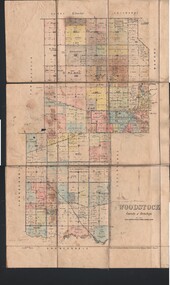 Bendigo Historical Society Inc.
Map - JACK FLYNN COLLECTION: WOODSTOCK, 4/07/1935
Map: Parish of Woodstock, County of Bendigo. Parish plan.By Authority H.J. Green. Govt Printer. Drawn and Reproduced at the Dept of Lands and Survey, Melbourne Victoria. 4.7.35map, bendigo, parish plan, woodstock -
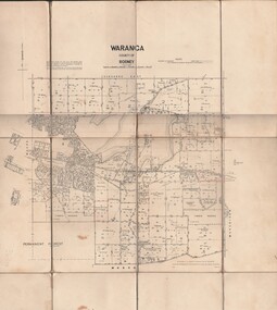 Bendigo Historical Society Inc.
Map - JACK FLYNN COLLECTION: WARANGA, 1959
Map: Parish of Waranga, County of Rodney. Parish plan.By Authority. A.C. Brooks. Government Printer Melbourne. Drawn and Reproduced at the Department of lands and survey. Melbourne 1959.map, rodney, parish plan, waranga -
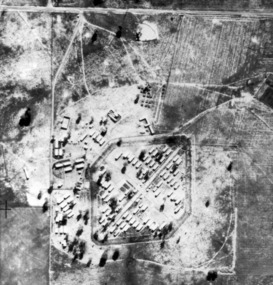 Tatura Irrigation & Wartime Camps Museum
Photograph, early to mid 1940's
Obtained from State Governmant Lands Department.Black and white photo of camp 4 compound.aerial photo of camp4, japanese family camp, photo taken in 1946 -
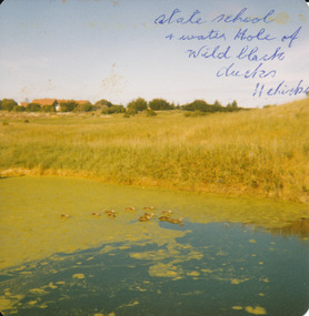 Port Fairy Historical Society Museum and Archives
Photograph
Powling wet lands before being protectedState school and water hole of wild black ducks 11 chickswetlands, powling, avery street, water -
 Clunes Museum
Administrative record - LICENSE BOOK, GARDEN LICENCE 5/
RECEIPT BOOK FOR DEPARTMENT OF LANDS AND SURVEY FOR THE YEARS 1889 - 1891 . LICENCE COSTING 5/- WAS ISSUED TO RESIDENTS TO PERMIT THEM TO ENTER UPON CROWN LANDS NOT EXCEEDING IN AREA. ONE ACRE AS SPECIFIED HEREUNDER, FOR PURPOSES OF GARDEN AND RESIDENCE.BLUE CARDBOARD COVERERED BOOK CONTAINING RENEWALS OF GARDEN LICENCE 5/- COVERING YEARS 1889 TO 1891. RECEIPT NOs 304811 TO 304830local history, book, licence, receipt, garden -
Glenelg Shire Council Cultural Collection
Photograph - Photograph - Cliff Street Portland, 1960-1979
Black and white photo. Cliff Street from beach in front of Courthouse. From left - corner of Courthouse, Town Hall, Public Lands and Harbour Offices, Watch House and Post Office. -
 Bendigo Historical Society Inc.
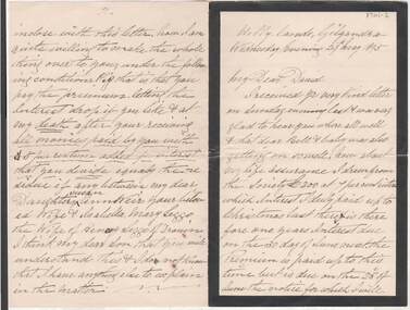
Document - E DOWLING COLLECTION: JOHN LITHGOW LETTER
Two letters from John Lithgow of Hilly Lands, Gilgandra, dated 29 May 1895. One addressed to his son-in-law David Weir, the other to his daughter Annie.genealogy, family, lithgow, letters, john lithgow, david lithgow, hilly lands, gilgandra (nsw), henry leggo, isabella mary leggo, drouin (vic), susan ann weir -
Bendigo Historical Society Inc.
Map - VICTORIA, Circa 1926
Map: Map showing Counties, including Railway lines and Geographic features. Compiled and engraved at the Department of Lands and Survey Melbourne, Revised October 1926 ( number 184 in Map Cupboard 1)map, victoria, counties, counties of victoria, geographic features -
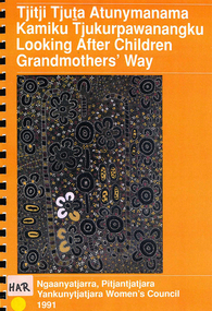 Victorian Aboriginal Corporation for Languages
Book, Jo Harrison, Tjitji tjuta atunymanama kamiku tjukurpawanangku =? looking after children grandmothers' way : report to the Child Protection Policy and Planning Unit, S.A., on the Child Protection Project, 1991
This report presents the results of a project that looked at the attitudes to child protection of Pitjantjatjara women living on the AP lands in South Australia. It also looks at the implications of the views and experiences discussed by the women interviewed.colour illustrations, mapspitjantjatjara, child abuse, child welfare, social policy -
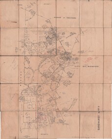
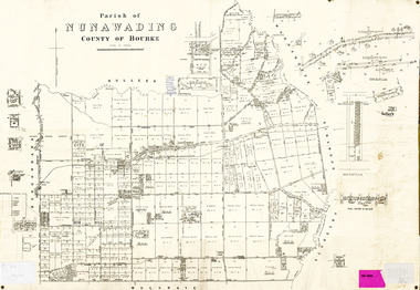 Whitehorse Historical Society Inc.
Legal record - Map, Parish of Nunawading, c1930
Office of Lands and survey map, 1864 with many further subdivisions of 1870 onwards added.Office of Lands and survey map, 1864 with many further subdivisions of 1870 onwards added. Boundaries of City of Box Hill included. Note added re Slater's land in Blackburn North. Office of Lands and survey map, 1864 with many further subdivisions of 1870 onwards added. maps, shire of blackburn and mitcham, city of box hill, slater family -
Whitehorse Historical Society Inc.
Article, Bowling Green gets the green light
Nunawading Council has reaffirmed its recent decision on the establishment of a bowling green at Mitcham.Nunawading Council has reaffirmed its recent decision on the establishment of a bowling green at Mitcham. Blackburn A.L.P. declared opposition to the spending of ratepayers' money on the project and opposed the use of park lands.Nunawading Council has reaffirmed its recent decision on the establishment of a bowling green at Mitcham. lawn bowls, city of nunawading, mitcham bowling club -
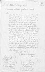 Whitehorse Historical Society Inc.
Letter - Correspondence, Roads, n.d
Request from 'Residents of Ringwood' to President of Board of Lands & Works, the Hon. Mr Casey for provision of a road alternative to 'Blood's Hill ' route. Signed by J. M. Setford and others. n.d.roads and streets, setford, j.m., ringwood, clements, a.b., blazey, w.r., parr, william, maggs, joseph, morriss, james, burge, william, holmes, william, hatfield, h., leach, g.w. -
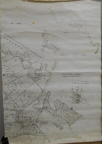
Bendigo Historical Society Inc.
Map - PANNOOMILLOO : COUNTY OF BENDIGO, 1957
Map. Pannoomilloo, County of Bendigo, Pannoobamawm, Milloo, Warragamba, Diggorra, Property Allotments. Drawn and Reproduced at the Department of Lands and Survey,1957. Price 2/-. (number 412 in Map Cupboard 1 ).W.M. Houston, Government Printer, Melbourne.bendigo, hospital -
Port Melbourne Historical & Preservation Society
Map - Foreshore, Sandridge, 1840
Bromide of surveyor's sketch of the foreshore of Sandridge (Liardet's Beach), 1840, showing Pier and Marine hotels with respective jetties. Originals with Lands Department, Melbourne. (possibly the work of William Wedge DARKE?) '5' on backbusiness and traders - hotels, piers and wharves, william wedge darke -
 Bendigo Historical Society Inc.
Book - LANDS OFFICE: INDEX LANDS AND SURVEY
Index lands and Survey. Sandhurst, Kangaroo Flat, Eaglehawk, White Hills, And Nerring. Land Sales, Beginning April 17, 1854. The last entry is dated 23.9.74. markings on spine of book are at top 04 in black, in gold lettering index lands and Survey, in black Bendigo, Eaglehawk, Kangaroo Flat White Hills and Nerring, near the bottom is the letter B in black, a white sticker with the letters VV. Read in conjunction with 2239 (a to g), located in Box 77.lands office, index, survey -
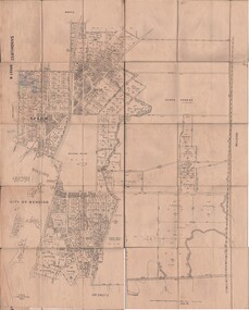
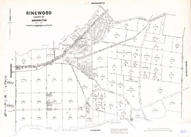 Ringwood and District Historical Society
Map - Parish of Ringwood, County of Mornington, Victoria, Original Land Owners
Laminated Parish map of Ringwood detailing original Land Owners' names, property locations and acreages. Details reproduced in 1957 by the Department of Lands and Survey, Melbourne, from original surveys of varying dates. -
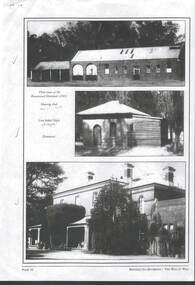 Bendigo Historical Society Inc.
Photograph - RAVENSWOOD CROWN LANDS
3 x black and white Photographs,- photocopy of page 34 of Bendigo Its Environs - The Way It Was - Ravenswood Crown Lands, three views at the Ravenswood Homestead c2003. Wool shed, Chapel ,Homestead.photograph, building, house -
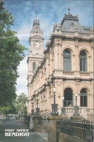 Bendigo Historical Society Inc.
Postcard - BENDIGO POST OFFICE COLLECTION: POST OFFICE
Coloured postcard of the Bendigo post office. Opened in 1887 as Sandhurst Public Offices, it was occupied by the Colonial Posts, Telegraphs, Police, Water supply, Sub-Treasury and Crown Lands department and Postmaster's quarters.bendigo, buildings, post office -
Whitehorse Historical Society Inc.
Map, Melbourne and suburbs, 1923
Section of map 'Melbourne and Suburbs' compiled at the Department of Lands and Survey, Melbourne by E. S. Hilcke, March 1923, reprinted 1940.Section of map 'Melbourne and Suburbs' compiled at the Department of Lands and Survey, Melbourne by E. S. Hilcke, March 1923, reprinted 1940. Scale 40 chains: 1 inch. - Shire of Blackburn and MitchamSection of map 'Melbourne and Suburbs' compiled at the Department of Lands and Survey, Melbourne by E. S. Hilcke, March 1923, reprinted 1940.department of lands and surve, melbourne and suburbs -
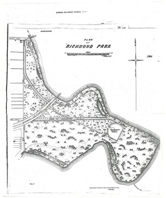 University of Melbourne, Burnley Campus Archives
Plan - Photocopy, A.L. Martin et al, Plan of Richmond Park, 1872
Layout of Richmond Park showing railway line, Pic-Nic Station, Swan Street extension and Horticultural Society's Garden. 3 photocopies of plan surveyed and drawn by A.L. Martin, Authorised Surveyor. Photolithographed at Dept of Lands and Survey by J. Noone 6th Sept. 1872. Showing the entire park and the Horticultural Society's Garden.richmond, parks, a.l. martin -
 Bendigo Historical Society Inc.
Map - JACK FLYNN COLLECTION: TARNAGULLA, 13/05/1922
Map: Parish of Tarnagulla . This Item is in very poor condition.By Authority, A. J. Mullen, Government Printer, Melbourne. Lithographed at the Department of Lands and Survey, Melbourne by W. J. Butsonmap, gladstone, parish plan, tarnagulla -
 Bendigo Historical Society Inc.
Map - JACK FLYNN COLLECTION: TOWNSHIP OF STANHOPE, December 1950
Map: Township of Stanhope, Parish of Girgarre, County of Rodney. Parish plan.By Authority J. J. Gourley, Government Printer, Melbourne. Drawn and Reproduced at the Dept, of Lands and Survey, Melbourne, Victoria.map, rodney, township, stanhope -
 Bendigo Historical Society Inc.
Map - JACK FLYNN COLLECTION: SANDHURST SHEET 6, January 1947
Map: Parish of Sandhurst Sheet 6. County of Bendigo. Parish plan.By Authority J. J. Gourley, Government Printer, Melbourne. Drawn and Reproduced at the Dept, of Lands and Survey, Melbourne, Victoria.map, bendigo, parish plan, sandhurst sheet 6 -
 Bendigo Historical Society Inc.
Map - JACK FLYNN COLLECTION: SANDHURST SHEET 2, January 1947
Map: Parish of Sandhurst Sheet 2, County of Bendigo. Parish plan.By Authority J. J. Gourley, Government Printer, Melbourne. Drawn and Reproduced at the Dept, of Lands and Survey, Melbourne, Victoria.map, bendigo, parish plan, sandhurst sheet 2 -
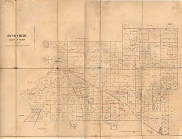 Bendigo Historical Society Inc.
Map - JACK FLYNN COLLECTION: RUNNYMEDE, June 1946
Map: Parish of Runnymede, County of Rodney. Parish plan.By Authority: J.J. Goourley, Government Printer, Melbourne. Drawn and Reproduced at the Lands and Servey, Melbourne, Victoria. June, 1946.map, rodney, parish plan, runnymede -
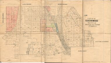 Bendigo Historical Society Inc.
Map - JACK FLYNN COLLECTION: RAVENSWOOD, 12/12/1922
Map: Parish of Ravenswood, Counties of Bendigo and Talbot. Parish plan.By Authority A.J. Mullet Government Printer Melbourne. Photo Lithographed at the Department of lands and Survey, Melbourne by W.J. Butsonmap, bendigo, parish plan, ravenswood -
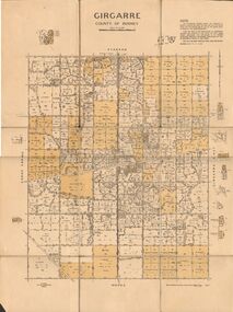 Bendigo Historical Society Inc.
Map - JACK FLYNN COLLECTION: GIRGARRE, 14/10/1943
Map: Parish of Girgarre. County of Rodney. Parish plan.By Authority, H.E. Daw, Government Printer Melbourne. Drawn and produced at the Dept of Lands and Survey, Melbourne, Victoria. 14.10.1943map, rodney, parish plan, girgarre, county of rodney -
 Bendigo Historical Society Inc.
Map - JACK FLYNN COLLECTION: ECHUCA NORTH, November 1953
Map: Echuca North, County of Rodney. Parish plan.By Authority: W.M. Houston, Government Printer. Drawn and Reproduced at the Dept., of Lands and Survey Melbourne, Victoria. November 1953map, rodney, parish plan, echuca north rodney -
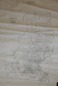 Bendigo Historical Society Inc.
Map - JACK FLYNN COLLECTION: HUNTLY, August 1954
Map: Parish of Huntly, County of Bendigo. Parish plan.By Authority W.M. Houston, Government Printer. Drawn and Reproduced at the Dept, of Lands and Survey, Melbourne, Victoria. August 1954.map, bendigo, parish plan, huntly