Showing 1408 items
matching maroondah
-
 Ringwood and District Historical Society
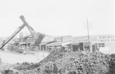
Photograph, Maroondah Highway Central, Ringwood. Roadworks in Maroondah Highway, c1926
2 photographs (1 large, 1 small sepia)Nil -
 Ringwood and District Historical Society
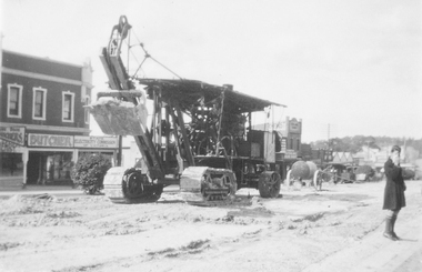
Photograph, Maroondah Highway Central, Ringwood. Roadworks in Maroondah Highway, c1926
Black and white photograph (2 copies- 1 large, 1 small)Nil -
 Ringwood and District Historical Society
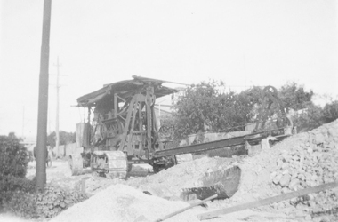
Photograph, Maroondah Highway Central, Ringwood. Roadworks on Maroondah Highway, 1935
2 photographs (1 large black and white, 1 small sepia)Nil -
 Ringwood and District Historical Society
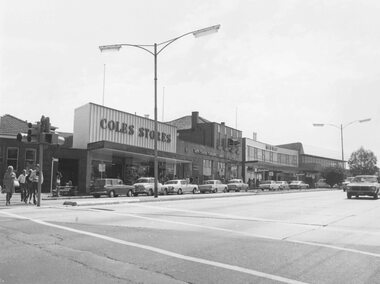
Photograph, Maroondah Highway Central, Ringwood. Shops in Maroondah Highway looking east from Ringwood Street. c1974
Black and white photographImage shows shops on north side of the road including Coles Stores, State Savings Bank, and Midway Arcade. -
 Ringwood and District Historical Society
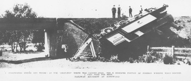
Photograph, Ringwood derailment on 11 Feb 1908 at Wantirna Rd. underpass looking north. Maroondah Highway near trees beyond underpass
Black and white photographs - 2 copiesPrinted directly below photographs, "1. overturned engine and tender at the 'dead end' which was carried away. The X indicates position of fireman McKeone when rescued. 2. View from the road. Railway accident at Ringwood". Typed below photograph, "Ringwood derailment 1902 at Wantirna Rd. underpass looking north. Maroondah Highway near trees beyond underpass". Date incorrect, should be 11 Feb 1908 (as per item 2019) - refer to The Argus article published on Wednesday 12 February 1908, page 7. Thanks to railway enthusiast Neal Glover for pointing out the error. -
 Ringwood and District Historical Society
Document, List of bushland reserves in Maroondah - early 2000
Typed document"Attached to List" Hand written note from Helen Moss to Gayle Abbe ( Archivist Ringwood Historical Society) "Here is some information on Dexters Bush and a report I prepared on the bushland reserves in Maroondah which mentions many of the relevant Ringwood reserves. There is also a copy of my phone list for reserves contacts. Roger Lord is listed - so is Anne Kaufman who knows the Angus Avenue/Ruthven Way area very well and may be able to suggest some additions to your heritage list. It would also be worth talking to Eva about the Alexander's land, which is next to Dexter's, on the Dandenong Creek. Good luck, Helen Moss. -
 Ringwood and District Historical Society
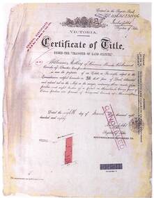
Document - Folder, Landata Certificates - Part of Crown Portion Six, (Lots 1-4 and numbers 70-90) Maroondah Highway, Parish of Ringwood, Victoria
27 A4 pages of colour photocopied certificates with typewritten summaries, including Certificate of Title Vol 1156 Fol 231096, 8th March 1880. Certificate of Title Vol 1440 Fol 930, 14th March 1883. Certificate of Title Vol 8487 Fol 090, 28th January 1964. Certificate of Title Vol 9019 Fol 634, 5th December 1973. Certificate of Title Vol 3711 Fol 742129, William John Harnwell, 1st August 1913. Certificate ot Title Vol 6552 Fol 1310305, 5th June 1942. Certificate of Title Vol 5282 Fol 1056207, Arthur Clifton Beilby, 19th July 1927. Certificate of Title Vol 6573 Fol 1314497, Florence Beatrice McGoldrick, Lot 4 on Subdivision 14786, Whitehorse Road, Ringwood, 18th August 1942. Proprietors and transferees include: William Astley of Richmond, Compositor, Marianne Thomson of Jolimont, Spinster, Margaret McGillivray of Ringwood, Spinster, George Frederick Burgess Wilsmore of Ringwood, Railway Employee, Leslie Wilsmore, John Wilsmore, Lionel Wilsmore, 90 Whitehorse Road Ringwood, B.T. Building Aust P/L, Lot 1 of subidivision 35788, Whitehorse Road Ringwood, Maliblue P/L 33-35 Ruthven Way Ringwood East, Hesketh Motor Cycles P/L, 70 Maroondah Highway Ringwood, Arthur Clifton Beilby of Ringwood, Storekeeper, Florence Beatrice McGoldrick and Oscar Edward John McGoldrick of "Carrum", Whitehorse Road Ringwood, Elsie May McGoldrick, 82 Whitehorse Road Ringwood, Douglas Murray and Ronald Arthur Mason, H.W.P Tortice and D.M. Tortice, V.B. Rowe. -
 Ringwood and District Historical Society
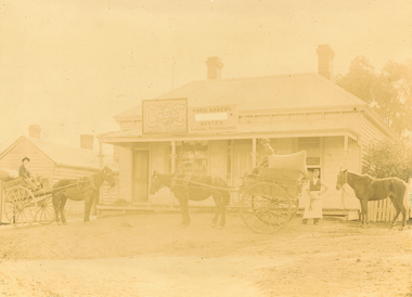
Photograph, Maroondah Highway East, Ringwood c1920. 'Paris Bakery - Baker and General Storekeeper' (Owned by the Herry Family.)
2 photographs (1 black and white, 1 sepia)Image shows building on Maroondah Highway with two horse driven carts at front, and another gentleman holding a horse. Louis Herry had a bakery and general store in Lilydale and opened another in Mount Dandenong Road, opposite the Club Hotel. His wife, Kate, mostly ran the Ringwood store. The store was previously owned by the Blood Bros, after they moved premises closer to the railway station. From the Place of Many Eagles book, "Louis was born in Purdu, France, in 1855, and came to Ringwood from Walhalla in 1887 and erected a weatherboard house and shop opposite the Club Hotel, using a Miner's Right to secure the land. When he arrived, Louis was a married man with three children, Leopold (1882), Marie (1884), John (1886). He had married Kate Handforth at Walhalla in 1879. In later years Elizabeth, Minellia, Louis and Denise were born. Kate's father was known as the midwife of the Gippsiand township because he had once been a fourth year medical student in England, but earnt a living as a goldbuyer in Victoria. Marie Herry would grow up remembering her grandfather calling sometimes at Ringwood; he would bring the children jubilee Mixture to eat and he carried a revolver in his pocket. Often he would play the violin while Marie would stepdance on the kitchen table." Leo served in WWI, whose name appears on the Ringwood Clocktower. -
 Ringwood and District Historical Society
Newspaper, Scrapbook Clipping, Library Collection, Ringwood, Victoria
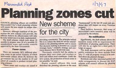
Newspaper Clipping from "The Maroondah Post", 1/7/1997. Planning zones cutCouncil planning officers are confident Maroondah City's draft planning scheme will ensure the area retains its unique characteristics. The council officers believe its effectiveness will only be truly tested once it is fully implemented. -
 Ringwood and District Historical Society
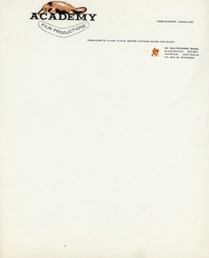
Memorabilia - Stationery, Stationery from 4 x Ron Mason Ringwood Businesses (undated), c 1940
Four businesses owned by Ron Mason all situated in Maroondah Highway Ringwood, Academy film Productions, Compass Video Market Craft, Maroondah Garden Supplies and Ringwood Self Service Grocery Pty. Ltd.in the 1940s.stationery from 4 businesses owned by Ron Mason 1 Academy film Productions -flyers and stationery 2 Compass Video market Craft - stationery 3 Maroondah Garden Supplies -Business cards and blank invoice sheets 4 Ringwood Self Service Grocery Pty. Ltd. blank writing sheets -
 Ringwood and District Historical Society
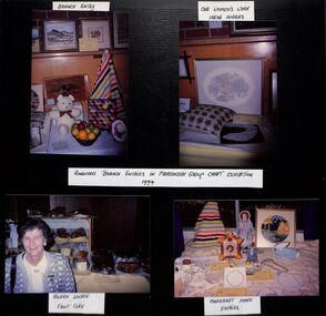
Photograph, Ringwood CWA craft Maroondah Group exhibit in 1994
Kindly scanned from Ringwood Branch archival collection -
 Ringwood and District Historical Society
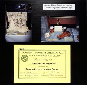
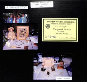
Photograph, Ringwood CWA entries and second prize certificate in Maroondah Highway Group Craft Exhibition in 1996
Kindly scanned from Ringwood Branch archival collection -
 Ringwood and District Historical Society
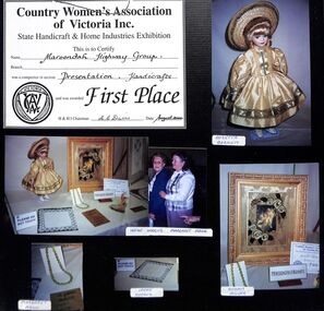
Certificate, Craft first prize to Ringwood CWA from Maroondah Highway Group in 1998
Kindly scanned from Ringwood Branch archival collection -
 Ringwood and District Historical Society
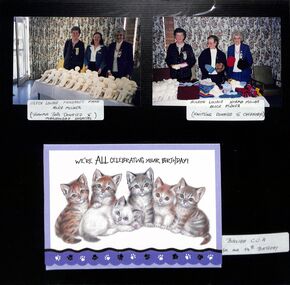
Mixed media, Ringwood CWA 54th birthday card and craft donations to Maroondah Hospital and others
Kindly scanned from Ringwood Branch archival collection -
 Ringwood and District Historical Society
Mixed media, Maroondah Highway Group craft exhibition in 2000, with certificate awarded to Ringwood CWA
Kindly scanned from Ringwood Branch archival collection -
 Ringwood and District Historical Society
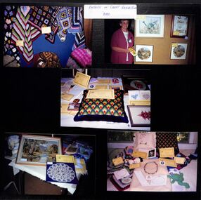
Photograph, Maroondah Highway Group craft entries in 2000
Kindly scanned from Ringwood Branch archival collection -
 Ringwood and District Historical Society
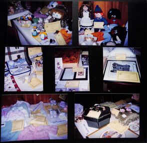
Photograph, Maroondah Highway Group craft entries circa 2000
Kindly scanned from Ringwood Branch archival collection -
 Ringwood and District Historical Society
Photograph, Maroondah Highway Group craft entries August 2000
Kindly scanned from Ringwood Branch archival collection -
 Ringwood and District Historical Society
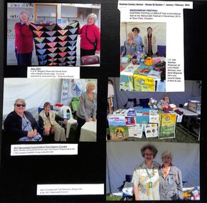
Photograph, CWA's Eastern Foothills Group at Maroondah Festival in November 2015
Kindly scanned from Ringwood Branch archival collection -
 Ringwood and District Historical Society
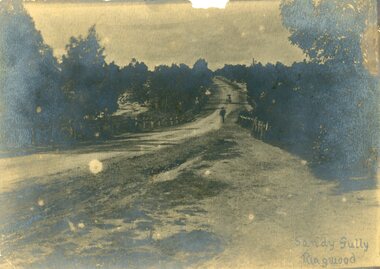
Photograph, Maroondah Highway, East Ringwood in 1870. Sandy Creek and Sandy Gully. Later dammed to create Ringwood Lake
One sepia photographWritten on back "1870", on front, "Sandy Gully, Ringwood". -
 Ringwood and District Historical Society
Photograph, Maroondah Highway East, Ringwood- 1965. Corner of Mt Dandenong Road before widening
Black and white photograph (3 separate images)Typed note on back of photograph: "M'dah Hwy, June 1965, before it was widened from Mt Dandenong on." -
 Ringwood and District Historical Society
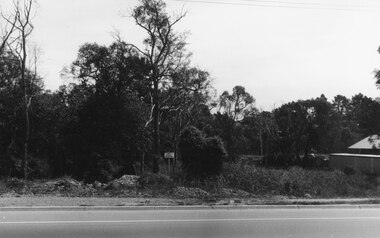
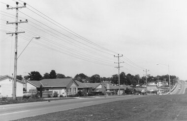
Photograph, Maroondah Highway East. Ringwood- c1969. North side near Peter Vergers Reserve
Black and white photographNil -
 Ringwood and District Historical Society
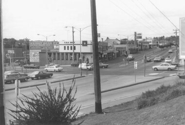
Photograph, Maroondah Highway East, Ringwood- 1976. Looking east from Warrandyte Road intersection
Black and white photographImage shows intersection with C.B.A. Bank on north east corner. Photograph taken mid 1976. -
 Ringwood and District Historical Society
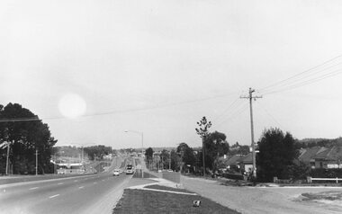
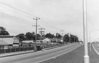
Photograph, Maroondah Highway East, Ringwood- 1969. Looking west towards Ringwood past Burnt Bridge shopping centre
Black and white photographNil -
 Ringwood and District Historical Society
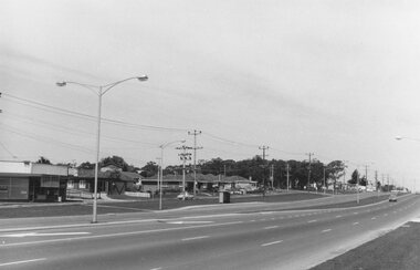
Photograph, Maroondah Highway East, Ringwood- 1969. Looking west towards Ringwood from Burnt Bridge area
Black and white photographNil -
 Ringwood and District Historical Society
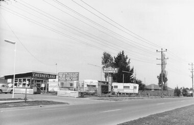
Photograph, Maroondah Highway East, Ringwood- 1969. Looking towards Ringwood from 'Chesneyland Mobile Homes'
Black and white photographNil -
 Ringwood and District Historical Society
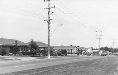
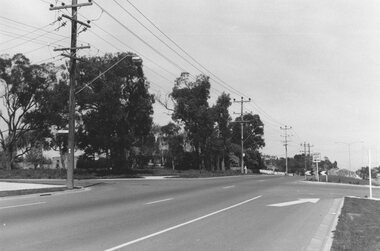
Photograph, Maroondah Highway East, Ringwood- 1969. Looking west towards Ringwood from Oban Road area
Black and white photographNil -
 Ringwood and District Historical Society
Photograph, Maroondah Highway East, Ringwood- 1969. Looking west towards Ringwood from Oban Road area
Black and white photographNil -
 Ringwood and District Historical Society
Photograph, Maroondah Highway East, Ringwood- 1969. Looking west towards Ringwood approaching Everard Road
Black and white photographNil -
 Ringwood and District Historical Society
Photograph, Maroondah Highway East, Ringwood- 1969. Looking west towards Ringwood from Everard Road
Black and white photographWritten on back of photograph: "Site of Cass's school, 1874. (1 acre left out of 5 acres).