Showing 3152 items matching "miles"
-
 Ringwood and District Historical Society
Envelope, Packet: Ringwood Historical Research Group Annual Reports 1962-1995, 1962-1995
Annual Reports - Ringwood Historical Research Group 1962-1995 +Additional Keywords: Pullin, R.A. / Deuter, M / Wedge, J.H. / Miles, E.T. / Radden -
 Bendigo Historical Society Inc.
Map - JACK FLYNN COLLECTION: KARA KARA, 1932
Map: County of Kara Kara, map sheet showing the whole of the County of Kara Kara and all of the Parishes within. Scale 2 miles to 1 inch.By Authority: W.M. Houston, Government Printer Melbourne. Department of Lands and Survey, Melbourne, 1958map, kara kara, county, kara kara -
 Clunes Museum
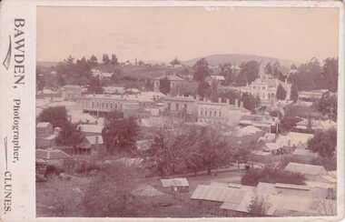
Photograph, BAWDEN PHOTOGRAPHER
SEPIA POSTCARD / PHOTOGRAPH - OVERVIEW OF CLUNES TOWNSHIP. S.S. BANK. CLUB HOTEL, POST OFFICE, TOWNHALL, WESLEY CHURCH AND TWO MILE HILL IN BACKGROUND.TO WISH YOU ALL GOOD CHRISTMAS BLESSINGS AND A HAPPY NEW YEAR. J. PATIENCE DEC. 1907.local history, photography, photographs, clunes township -
 Lakes Entrance Historical Society
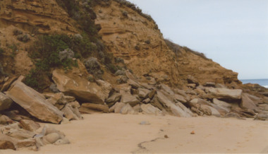
Photograph - Red Bluff 2008, Wendy Price, 1/08/2008 12:00:00 AM
This is the after photograph used in the 150 years Lakes Entrance 1858 to 2008 display held in October 2008 paired with image 03731 for displayColour photograph of west side of Red Bluff showing vegetation on the bluff rock and sand at the base situated on ninety mile beach Lake Tyers Victoria waterways, topography -
 Whitehorse Historical Society Inc.
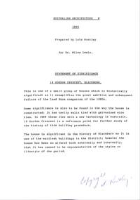
Document - Report, Conservation analysis of 18 Gordon Crescent, Blackburn, 1995
... Miles ...18 Gordon Crescent Blackburn. A conservation analysis undertaken by Lois Routley for Dr Miles Lewis, Lecturer in Architecture. For titles accompanying this study see A-SP-T 13,A-SP-T 14, A-SP-T 15, A-SP-T 16. Includes detailed history of development of the area and occupants of the house.gordon crescent, blackburn, no.18, land subdivision, lewis, miles, woods, john, coppin, george seth, freehold investment and banking company of australia ltd, wolseley crescent, blackburn, blackburn, quarterman, martha, clarke, arthur e, game, kate, t. r. b. morton & son., game, thomas robinson, urquhart, finlay, newman, jeffrey william forbes, newman, valerie, jones, ian, jones, joan, strickland, kenneth william, strickland, wilma dawn -
 Bendigo Historical Society Inc.
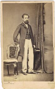
Photograph - ELMA WINSLADE WELLS COLLECTION: JOSEPH ROTHERHAM (GRANDFATHER )
COLLECTION OF PHOTOGRAPHS FROM MISS E.W.WELLS - PHOTO OF JOSEPH ROTHERHAM (GRANDFATHER ) / holding top hat / foot of photo - Gottheil Photo / rear of photo - logo of photographer - E. Gottheil - Photographer , 23, Assembly Row , Mile End , In consequence of re- arrangement of numbers this establishment is now known as Assembly House , 120 Mile End Road , E,/ reference is made to 'letter dated 24.9.1866 '.Gottheil Photophotograph, portrait, male, gottheil, elias -
 Federation University Historical Collection
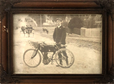
Photograph, Photograph of A.E. Sutton with motorcycle
Henry Sutton is a talented world-wide accepted inventor with inventions relating to the telephone, photography, wireless, cars, motorcycles, and bicycles as well as many more inventions. Henry was also one of four brothers that ran the Sutton's Music Store after the death of their Father Richard Sutton. Henry Sutton taught Applied Electricity at the Ballarat School of Mines in 1883 to 1886.Black and White Photograph of A.E. Sutton and motorcycle on which he won the first VMCC 100 Mile road road race in 1906, in a brown wooden framed.henry sutton, a.e. sutton, motorcycle, photograph, vmcc, race, winner -
Canterbury History Group
Map - Elgar's Special Survey, copied 1989
Map of "Elgar's Special Survey" 8 square miles chosen by Henry Elgar in 1841, showing the location of J.B.Maling's Paddock and house, 13 acres bought in 1864.camberwell, balwyn, deepdene, canterbury, surrey hills, elgar's special survey, land subdivision, maps, maling family -
 Lakes Entrance Historical Society
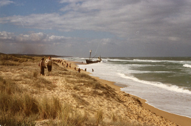
Photograph - Dageraad, 1981
Vessel went aground 26 April 1981Colour photograph showing view of the stranded fishing vessel Dagaraad which ran aground on the 90 mile beach. Many people on beach. Lakes Entrance Victoriaships and shipping, shipwrecks, media, coast, fishing industry -
Lakes Entrance Historical Society
Book, LERHS, Bunga Creek School 3365, 2010
Folder containing sparse information about the Bunga Creek State School no 3365 which was situated a few miles north east of the township Lakes Entrance Victoriaschools, education -
Lakes Entrance Historical Society
Book, Hewitt Geoff Bader Hans Dieter, Geometria, 2007
Report on the geomagnetic archaeological survey of areas of prograded Ninety Mile Beach shore in East Gippsland Victoria, immediately to the East and West of the artificial entrance to the Gippsland Lakes.waterways, topography, ships and shipping -
 Lakes Entrance Historical Society
Photograph - Lake Tyers Beach Caravan Park, Jan. 1983
Colour Photograph of Ninety Mile Beach caravan Park at Lake Tyers Beach Victoria. Shows house rooftop, caravans and LTB Road on right hand side aerial photograph, caravan parks, beaches -
 Lara RSL Sub Branch
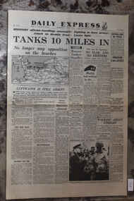
Newspaper - Daily Express UK Newspaper Dated 7/6/1944 - D_Day Continues - Tanks 10 Miles In, UK Newspaper
Daily Express UK Newspaper Dated 7/6/1944D_Day ContinuesDaily Express UK Newspaper Dated 7/6/1944 D_Day Continues - Tanks 10 Miles In , No Longer any Opposition on The Beaches , No Fightersd_day continues - tanks 10 miles in, no longer any opposition on the beaches, no fighters -
 Bendigo Military Museum
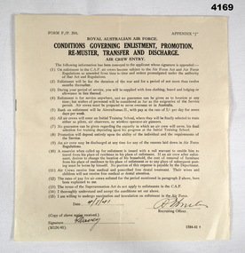
Document - RAAF ENTRY CONDITIONS, Royal Australian Air Force, C. WW2, issued 4.8.1941
The form issued to and signed by Frederick Gardner Davey No 410533 RAAF. Refer Cat No 3536P for his service details.Document form P./.P 39A detailing conditions governing enlistment, promotion, re - muster, transfer and discharge in the RAAF. All Black type on cream coloured paper.Two handwritten signatures and a date, “4/8.41”, “F Davey”, Possibly “Miles”raaf, conditions -
 Stawell Historical Society Inc
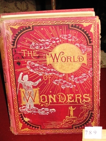
Book, Cassell Petter & Galpin, The World of Wonders, 1879
Awarded to Mip Hannah Miles, Mount Doran School July 6th 1879stawell education -
 8th/13th Victorian Mounted Rifles Regimental Collection
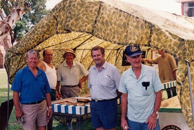
Photograph - Colour photograph of 5 men outside a display booth formed by a camoflaged parachute over a metal frame. Tables are set up displaying objects relating to Albury in WW11
Colour photograph of five men outside a display booth formed by a camouflaged parachute over a metal frame. Tables are set up displaying objects relating to Albury in WW1Lou Madjeric, Bill Woolford, Maurie Miles, Don Campbell, John Nealevmr, display, camouflage, buna barracks, albury -
 Whitehorse Historical Society Inc.
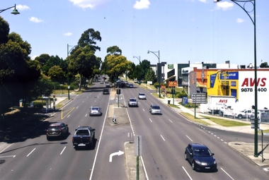
Photograph, Whitehorse Road, Blackburn, 2012
Railway Road is on the right. It is a one-way road leading into Blackburn Shopping Centre.See NP4006Coloured photograph of Whitehorse Road heading east towards Ringwood. Shops on the right are the beginning of the 'shopping mile', selling lights, computers, camping equipment, furnitures etc. - 2012whitehorse road, blackburn, roads, shops -
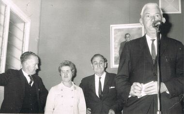 Bendigo Historical Society Inc.
Photograph - BERT GRAHAM COLLECTION: GROUP PHOTO
Black & white photograph, Bert Graham Collection, at the Bendigo East Bowls, Mr. Frank Miles is at the microphone, while Bert Graham and one lady and one man are in the background.bendigo, clubs, bendigo east bowling club -
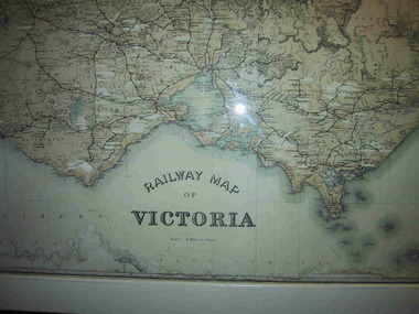 Parks Victoria - Mount Buffalo Chalet
Map, "Railway Map of Victoria"
Large framed map of Victoria, showing Victorias extensive rail network. Printed by Victorian Railways and is one of a number of 'framed pictures, particularly photographs of scenery, which have always been a feature of the Chalet.' (Pg 83. Historica, 2011) This map has been a permanent fixture situated in the hallway alongside the ballroom leading to the ski hire area since the 1950's and most likely earlier. Listed in Draft Inventory of Significant Collection ItemsLarge railway map of Victoria, Melbourne & Ballarat framed in white painted wood. Scale eight miles to one inch. Areas of the map have been whited out.Yes -
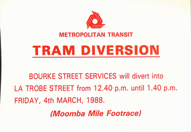 Melbourne Tram Museum
Poster, The Met, "Tram Diversion", 1988
Set of 2 Posters - printed on paper with an adhesive backing for: .1 - Moomba Mile - 4/3/1988 .2 - Moomba Festival Float Parade - 14/3/1988trams, tramways, operations, buses, moomba -
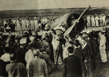 Ballarat Heritage Services
Photograph - Image, Sir Charles Kingsford-Smith and Captain P. Taylor Complete the Last Leg of a flight to California, 1934
Black and white photographic image of Sir Charles Kingsford-Smith and Captain P. Taylor after completing the las leg of a 7365 mile flight to California ahead of schedule.aeroplane, aviation, flight, charles kingsford smith, p.g. taylor, southern cross -
 Ballarat Tramway Museum
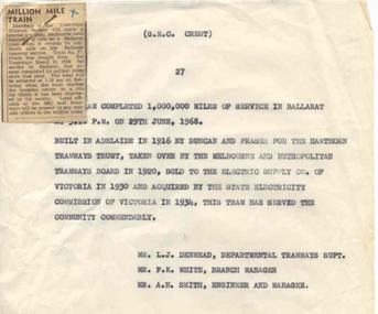
Newspaper, The Courier Ballarat, millionth mile on 27, Jun. 1968
Newspaper clipping from The Courier, Ballarat, prior to 29 June 1968, about the forthcoming trip by the Tramways Museum Society (TMSV) to ride on tram No. 27 when it records its millionth mile on the Ballarat Tramway system at 3.10pm on 29/6/1968. Was attached on donation to item 1847, with a pin in top left hand corner. Separated for storage. See image file for arrangement on donation. Note: Later review by D. Macartney in early 80's found that the SEC had miscalculated the distance travelled by 100,000 miles. The million miles occurred during service with the BTPS - written up somewhere in Fares Please! See Fares Please! in the 1980's.A purple colour cross in the top right hand corner.million miles, sec, tmsv -
 Federation University Historical Collection
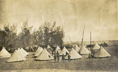
Postcard - photographic, Australian Camp at Sereapeum
An image of a number of Australian Soldiers During World War One posing in front of tents in Egypt.Verso: "Our Camp at [censored with blue pencil - probably Sereapeum]. In the background can be seen the plantation which grows for miles along the [Suez] Canal, and for miles back you see masts of the shows in the Canal."chatham family archive, chatham, holmes, world war, world war 1, world war i, world war one, suez -
Ringwood and District Historical Society
Envelope, Commonwealth Meteorology, Rainfall records kept by the Mile Family Ringwood (official record books). 1915-1958. History or Rainfall Observation at Ringwood 1969, 1915-1958
Rainfall records kept by the Miles family; Three record books, rain register - Commonwealth Meteorology 1915-1925, 1937-1947, 1948-1958; History of Rainfall Observation at Ringwood: 13 February 1969; See also re rainfall collection 3466 2-3-3 Box 2; See also re rainfall collection 3993 2-7-05 Envelope +Additional Keywords: Temple Miles, A -
 Bendigo Historical Society Inc.
Document - MINING REPORTS - LINE OF REEF AT YANKEE CREEK NEAR BENDIGO
BHS CollectionTyped photocopy of a letter dated September 19th, 1898, from W. H. Cundy, Underground Survey Office, Bendigo. Letter refers to a locality, eight miles due east from Bendigo, and five miles west from Hunt's line of Reef Ellesmere. The writer did not think there was any necessity for a special survey to define the position of the reef. Handwritten at the bottom of the letter: for Report by Whitelaw. See Progress Report No 10.document, gold, mining reports, line of reef at yankee creek near bendigo, underground survey office bendigo, c tillach, koch's pioneer battery, mr grieve, hallidays claim, w h cundy, whitelaw -
 Lakes Entrance Historical Society
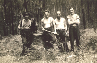
Photograph - Four Mile camp, Buchan East Gippsland Victoria, 1935-36
Black and white photograph of four bush workers with a dog, axe and fern hook or slasher, one man with a rifle at Four Mile camp Buchan Road East Gippsland Victoriaforestry, government services, topography -
 Lakes Entrance Historical Society
Photograph - North Arm Lakes Entrance, 2005 c
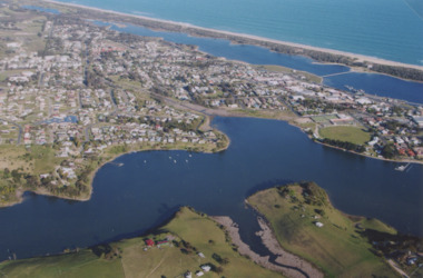
Also two colour photographs of North Arm area taken from Leigh and Judy Davies Blair Road Lakes Entrance number 03859.1 and 03859.2 sizes 10 x 15 cm and 15 x 10 cmColour aerial photograph showing Kalimna in foreground, North Arm, towhship, Cunninghame Arm and across to ninety mile beach and Bass Strait ocean beach Lakes Entrance Victoriaaerial photograph, settlement -
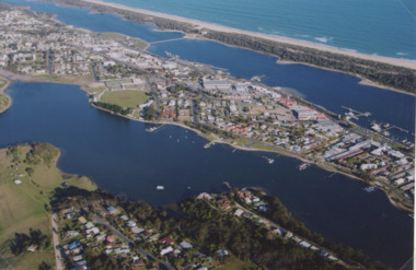 Lakes Entrance Historical Society
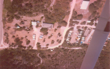
Photograph - North Arm Lakes Entrance, 2005
Colour aerial photograph showing North Arm, township, eastern end of Cunninghame Arm across to the ocean beach, Ninety Mile beach, Bass Strait Lakes Entrance Victoriaaerial photograph, aircraft, lakes entrance -
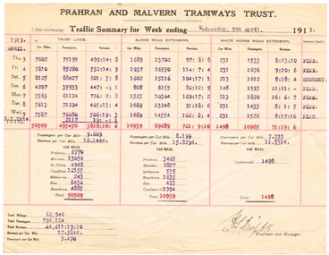 Melbourne Tram Museum
Document - Report, Prahran & Malvern Tramway Trust (PMTT), "Prahran and Malvern Tramways Trust - Traffic Summary for week ending 9th April 1919", Apr. 1919
Quarto sheet - printed and typed form - report - "Prahran and Malvern Tramways Trust - Traffic Summary for week ending 9th April 1919". Gives the car miles, passengers and revenue for each day of the reporting week. Gives details for the Trust lines, Burke Road extension and the White Horse Extension along with a summary of revenue, revenue per car mile and passengers per car mile. Also notes the weather conditions. Item .2 to .5 added 9-8-2018 from donation of Bob Wilson. .2 - Week ending 12/3/1919 .3 - ditto 19/3/1919 .4 - ditto 26/3/1919 .5 - ditto 2/4/1919trams, tramways, pmtt, tramcars, reports, passengers -
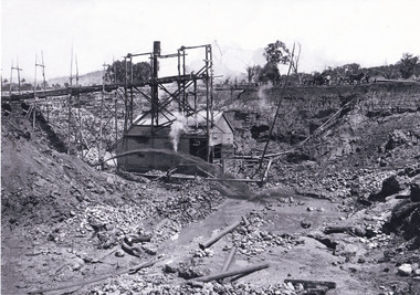 The Beechworth Burke Museum
Photograph, 1920 - 1930
Taken between circa 1920 - 1950 this photograph depicts the open mine in the Three Mile Mine at Barramutha. The mine was an important gold resource and was typically mined using a method known as hydraulic sluicing whereby high powered water jets are used to dislodge rock or move sediment. The remaining water sediment slurry is directed through sluice boxes to remove the gold. The Beechworth mining district was one of six mining districts established by the governor-in-council on 4th of January 1858 under the provisions of An Act for Amending the Laws Relating to the Goldfields (21 Vic no. 32).This photograph shows cultural and research value into the historical methods of hydraulic sluicing in the Beechworth mining disctrict. It also shows the evolution of the mining methods and has potential for understanding future engineering endeavors in the context of victorian mine goldfields.Black and White rectangular photograph printed on matte photographic paper.Reverse: Copied from original on loan from Webb (QLD)/ Donated Nov 2009/ Barnawatha Three Mile Mine c1920-1950 Minehead & Slicing/ Managed by John Weir, Peter Jensen, Jack Cox/ Owned by/ the Plain Bros then Parkinsons/ John worked for Pqarkinsons. three mile creek, three mile goldfields, three mile beechworth, goldfields, #beechworth, hydraulic mining, hydraulic sluice, burke museum