Showing 418 items
matching orchard district
-
 Eltham District Historical Society Inc
Photograph - Digital Photograph, Marguerite Marshall, Gordon Ford's Garden, 'Fulling', Pitt Street, Eltham, 10 November 2006
'Fulling', the half-hectare property at Pitt Street, Eltham was the home of landscape designer Gordon Ford and his wife Gwen. Ford bought the property in 1948, originally part of an orchard. The garden encapsulates the major trends of Australian garden design in the second half of the 20th century. The garden design is based on mass (plants) and void (paths and pools), textures and forms. It epitomises the Eltham style because of its relaxed informality and attraction to native wildlife. The mud brick house and designed and built by Ford commenced in 1948. Several extensions were added up to 1970 and were built by Graham Rose (Source: information panel for exhibition, n.d.) Covered under Heritage Overlay, Nillumbik Planning Scheme. Published: Nillumbik Now and Then / Marguerite Marshall 2008; photographs Alan King with Marguerite Marshall.; p147 A narrow timber gate opens onto a garden that has had a huge impact on natural garden development in Australia since the 1950s.1 Fulling, the half-hectare property at Pitt St, Eltham, was the home of the landscape designer, Gordon Ford, who died in 1999. The garden ‘encapsulates the major trends of Australian garden design in the second half of the 20th century...and epitomises the Eltham style of garden’.2 It in turn, was influenced by several Victorian major landscape designers of the mid 20th century – Ellis Stones, Peter Glass and Edna Walling. The gate opens onto a sandy gravel path, one of several, which wind around dramatic pools and what appear to be natural bush, but on close inspection are carefully integrated native, indigenous and exotic plantings. Retaining walls and steps of rock through the garden link different terrace levels. Lichen-covered boulders serve as steps across a pool, leading to the triple level mud-brick house. Ford bought the property, which was originally part of an orchard, in 1948. As the son of a Presbyterian minister, Ford received a good education, which included learning Latin. This was advantageous when he worked in plant sales for the Forestry Commission, before the Second World War. In the late 1940s, however, Ford turned to building and landscape gardening. He worked on the Busst house, an early mud-brick building designed by Alistair Knox and at the same time, Ford was employed by Ellis Stones. Knox described Ford as, ‘one of the funniest men of the district. ...Rocky’s (Ellis Stones) Depression stories and Gordon’s memory and quick tongue made the jobs the most enjoyable of all those hysterical times that made Eltham the centre of the eternal laugh, between the years of 1945 and 1950’.3 Ford’s house, like so many after the war, was built progressively, as more space was needed and formerly scarce materials became available. It began with an army-shed of timber-lined walls, now used as the kitchen. Ford then built what is now the lounge room, and the house grew ‘like topsy and on a shoestring,’ says his widow Gwen. A lot of second-hand materials such as window frames were used, a style made famous particularly with their extensive use at Montsalvat, the Eltham Artists’ Colony. The house was constructed as a joint venture with friends, including artist Clifton Pugh, who built Ford’s bedroom for £10. The polished floorboards and solomite (compressed straw) ceilings, interspersed with heavy beams, exude warmth. The result is a home of snug spaces, with soft light and garden vistas. Several other mud-brick buildings were constructed as needed, including a studio and units for bed-and-breakfast clients. The garden, which has been part of the Open Garden Scheme since the mid 1980s, is based on a balance of mass (plants) and void (paths and pools), textures and forms. It epitomises the Eltham style because of its relaxed informal ethos and attracts native animals. Wattlebirds, scrub wrens, pardalotes, currawongs, owls and even kangaroos, have been seen at Fulling. Gwen, a former English teacher who has worked on the garden since around 1970, urged and helped Ford write his book, The Natural Australian Garden.4 Several of Ford’s favourite trees are in the garden, including the native Casuarina or She-Oak. In spring, the garden is dusted with the purple Orthrosanthus multiflorus or blue native irises and rings with the calls of birds attracted to plants like the callistemons, correas and grevilleas.This collection of almost 130 photos about places and people within the Shire of Nillumbik, an urban and rural municipality in Melbourne's north, contributes to an understanding of the history of the Shire. Published in 2008 immediately prior to the Black Saturday bushfires of February 7, 2009, it documents sites that were impacted, and in some cases destroyed by the fires. It includes photographs taken especially for the publication, creating a unique time capsule representing the Shire in the early 21st century. It remains the most recent comprehenesive publication devoted to the Shire's history connecting local residents to the past. nillumbik now and then (marshall-king) collection, eltham, fulling, gordon ford garden, pitt street, eltham mud brick buildings, mud brick house -
 Whitehorse Historical Society Inc.
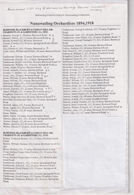
Document, Nunawading Orchardists, ?
Lists of Nunawading orchardists from 1894non-fictionLists of Nunawading orchardists from 1894nunawading, orchardists, orchards -
 Merbein District Historical Society
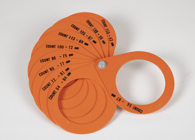
Tool - Sizing rings, Citrus
this was significant in sizing of oranges so you know the size of the oranges in the boxa orange color sizing rings of 10 different sizes each ring has count labels on it sizing tool, citrus, oranges, mandarines, orchards, merbein -
 Merbein District Historical Society
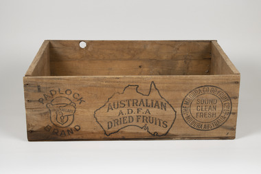
Equipment - Box, Wood
wooden box Australian ADFA Dried Fruits, Padlock Reliable Brand, The Mildura Co-op Fruit Coy Ltd Australia, Currants 1238 Crown 1238dried fruit, mildura co-op, padlock, adfa, orchards, currant, three crown -
 Eltham District Historical Society Inc
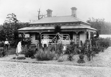
Negative - Photograph, Allwood, Hurstbridge, 1905
Allwood, Hurstbridge, 1905. Hurst/Gray family in the garden in front of the Victorian style Allwood house with lace iron work on the verandah. Left to Right: Whittaker, Mrs. Catherine Hurst, Frederick George Hurst (at rear), Hurst Gray, Mrs. Frances Ellen Gray (nee Hurst), William (Bill) George Gray, Sylvia Gray (later Birch). Frederick and Catherine Hurst relocated this Victorian style weatherboard home from an inner Melbourne suburb to its present site on their Allwood property. Mr Charles Verso, builder and farmer, reassembled and refurbished the home for the Hurst’s. In 1897 Frederick and Catherine’s daughter, Frances Ellen, married William (Bill) George Gray of Cottlesbridge and the newlyweds moved into the new house. Frederick and Catherine Hurst moved into a little cottage, ‘Mia Mia’, on the other side of the Diamond Creek. William and Frances Gray established Allwood Nursery and by 1900 most of the Allwood property was under orchard, largely apples, pears, cherry plums and peaches. They also developed an extensive nursery, growing seedling stock for supply to other local orchardists and the overseas market. Cross Ref: Sepp_1018 Source: Mrs. Ferguson, Hurstbridge This photo forms part of a collection of photographs gathered by the Shire of Eltham for their centenary project book,"Pioneers and Painters: 100 years of the Shire of Eltham" by Alan Marshall (1971). The collection of over 500 images is held in partnership between Eltham District Historical Society and Yarra Plenty Regional Library (Eltham Library) and is now formally known as The Shire of Eltham Pioneers Photograph Collection.' It is significant in being the first community sourced collection representing the places and people of the Shire's first one hundred years.Digital image 4 x 5 inch B&W Neg Print 20 x 25 cm (x2)shire of eltham pioneers photograph collection, hurstbridge, hurst family, sylvia gray, hurst gray, whittaker, allwood house, allwood, frederick george hurst, gray family, mrs. catherine hurst, mrs. frances ellen gray (nee hurst), william (bill) george gray -
 Eltham District Historical Society Inc
Photograph - Digital Photograph, Alan King, Blue Lake, Plenty Gorge Park, 2008
A quarry was transformed into the Blue Lake. Published: Nillumbik Now and Then / Marguerite Marshall 2008; photographs Alan King with Marguerite Marshall.; p179 The dramatic steep-sided Plenty Gorge lies along the divide of two geological areas, and separates the Nillumbik Shire and the City of Whittlesea. On the Nillumbik side are undulating hills and sedimentary rock, and in Whittlesea, lies a basalt plain formed by volcanic action up to two million years ago. This provides the Plenty Gorge Park with diverse vegetation and habitats, making it one of Greater Melbourne’s most important refuges for threatened and significant species. The park, established in 1986, consists of around 1350 hectares, and extends 11 kilometres along the Plenty River, from Greensborough to Mernda. It provides a wildlife corridor for around 500 native plant and 280 animal species. The area’s plentiful food and water attracted the Wurundjeri Aboriginal people and then European settlers. By 1837 squatters had claimed large runs of land for their sheep and cattle. The Plenty Valley was among the first in the Port Phillip District to be settled - mainly in the less heavily timbered west - and was proclaimed a settled district in 1841.But by the late 1880s, the settlers’ extensive land clearing for animal grazing, then agriculture, depleted the Wurundjeri’s traditional food sources, which helped to drive them away. Many Wurundjeri artefacts remain (now government protected), and so far 57 sites have been identified in the park, including scarred trees, burial areas and stone artefacts. Pioneer life could be very hard because of isolation, flooding, bushfires and bushrangers. Following the Black Thursday bushfires of 1851, basalt was quarried to build more fire-resistant homes. Gold discoveries in the early 1850s swelled the population, particularly around Smugglers Gully; but food production made more of an impact. In the late 1850s wheat production supplanted grazing. In the 1860s the government made small holdings available to poorer settlers. These had the greatest effect on the district, particularly in Doreen and Yarrambat, where orchards were established from the 1880s to 1914. Links with a prominent early family are the remains of Stuchbery Farm, by the river’s edge bounded by Smugglers Gully to the north and La Trobe Road, Yarrambat, to the east. The Stuchberys moved to the valley in 1890, and the family still lives in the area. In 1890, Alfred and Ada first lived in a tent where four children were born, then Alfred built the house and outbuildings around 1896. They planted an orchard, then a market garden, and developed a dairy. The family belonged to the local Methodist and tennis communities. Their grandson Walter, opened the Flying Scotsman Model Railway Museum in Yarrambat, which his widow, Vi, continues to run. Wal was also the Yarrambat CFA Captain for 22 years until 1987. Walter sold 24 hectares in 1976 for development - now Vista Court - and in 1990, the remaining 22.6 hectares for the park. Remaining are an early stone dairy and remnants of a stone barn, a pig sty and a well. Until it was destroyed by fire in 2003, a slab hut stood on the Happy Hollow Farm site, at the southern end of the park. The hut is thought to have been built in the Depression around 1893. This was a rare and late example of a slab hut with a domestic orchard close to Melbourne. Emmet Watmough and his family first occupied the hut, followed by a succession of families, until the Bell family bought it around 1948. There they led a subsistence lifestyle for 50 years, despite encroaching Melbourne suburbia. The Yellow Gum Recreation Area includes the Blue Lake, coloured turquoise at certain times of the year. Following the 1957 bushfires, this area was quarried by Reid Quarries Pty Ltd for Melbourne’s first skyscrapers, then by Boral Australia. However in the early 1970s water began seeping into the quarry forming the Blue Lake and the quarry was closed. The State Government bought the site in 1997 and opened it as a park in 1999.This collection of almost 130 photos about places and people within the Shire of Nillumbik, an urban and rural municipality in Melbourne's north, contributes to an understanding of the history of the Shire. Published in 2008 immediately prior to the Black Saturday bushfires of February 7, 2009, it documents sites that were impacted, and in some cases destroyed by the fires. It includes photographs taken especially for the publication, creating a unique time capsule representing the Shire in the early 21st century. It remains the most recent comprehenesive publication devoted to the Shire's history connecting local residents to the past. nillumbik now and then (marshall-king) collection, blue lake, plenty gorge park -
 Eltham District Historical Society Inc
Photograph - Digital Photograph, Marguerite Marshall, Stuchbery Farm dairy, 14 March 2008
Stuchbery Farm was situated on the Plenty River bounded by Smugglers Gully to the north and La trobe Road, Yarrambat, to the east. Alan and Ada Stutchbery moved to the valley in 1890, first living in a tent where four children were born. Alfred built a home and outbuildings around 1896. They planted an orchard, then a market garden and developed a dairy. Published: Nillumbik Now and Then / Marguerite Marshall 2008; photographs Alan King with Marguerite Marshall.; p179 The dramatic steep-sided Plenty Gorge lies along the divide of two geological areas, and separates the Nillumbik Shire and the City of Whittlesea. On the Nillumbik side are undulating hills and sedimentary rock, and in Whittlesea, lies a basalt plain formed by volcanic action up to two million years ago. This provides the Plenty Gorge Park with diverse vegetation and habitats, making it one of Greater Melbourne’s most important refuges for threatened and significant species. The park, established in 1986, consists of around 1350 hectares, and extends 11 kilometres along the Plenty River, from Greensborough to Mernda. It provides a wildlife corridor for around 500 native plant and 280 animal species. The area’s plentiful food and water attracted the Wurundjeri Aboriginal people and then European settlers. By 1837 squatters had claimed large runs of land for their sheep and cattle. The Plenty Valley was among the first in the Port Phillip District to be settled - mainly in the less heavily timbered west - and was proclaimed a settled district in 1841. But by the late 1880s, the settlers’ extensive land clearing for animal grazing, then agriculture, depleted the Wurundjeri’s traditional food sources, which helped to drive them away. Many Wurundjeri artefacts remain (now government protected), and so far 57 sites have been identified in the park, including scarred trees, burial areas and stone artefacts. Pioneer life could be very hard because of isolation, flooding, bushfires and bushrangers. Following the Black Thursday bushfires of 1851, basalt was quarried to build more fire-resistant homes. Gold discoveries in the early 1850s swelled the population, particularly around Smugglers Gully; but food production made more of an impact. In the late 1850s wheat production supplanted grazing. In the 1860s the government made small holdings available to poorer settlers. These had the greatest effect on the district, particularly in Doreen and Yarrambat, where orchards were established from the 1880s to 1914. Links with a prominent early family are the remains of Stuchbery Farm, by the river’s edge bounded by Smugglers Gully to the north and La Trobe Road, Yarrambat, to the east. The Stuchberys moved to the valley in 1890, and the family still lives in the area. In 1890, Alfred and Ada first lived in a tent where four children were born, then Alfred built the house and outbuildings around 1896. They planted an orchard, then a market garden, and developed a dairy. The family belonged to the local Methodist and tennis communities. Their grandson Walter, opened the Flying Scotsman Model Railway Museum in Yarrambat, which his widow, Vi, continues to run. Wal was also the Yarrambat CFA Captain for 22 years until 1987. Walter sold 24 hectares in 1976 for development - now Vista Court - and in 1990, the remaining 22.6 hectares for the park. Remaining are an early stone dairy and remnants of a stone barn, a pig sty and a well. Until it was destroyed by fire in 2003, a slab hut stood on the Happy Hollow Farm site, at the southern end of the park. The hut is thought to have been built in the Depression around 1893. This was a rare and late example of a slab hut with a domestic orchard close to Melbourne. Emmet Watmough and his family first occupied the hut, followed by a succession of families, until the Bell family bought it around 1948. There they led a subsistence lifestyle for 50 years, despite encroaching Melbourne suburbia. The Yellow Gum Recreation Area includes the Blue Lake, coloured turquoise at certain times of the year. Following the 1957 bushfires, this area was quarried by Reid Quarries Pty Ltd for Melbourne’s first skyscrapers, then by Boral Australia. However in the early 1970s water began seeping into the quarry forming the Blue Lake and the quarry was closed. The State Government bought the site in 1997 and opened it as a park in 1999.This collection of almost 130 photos about places and people within the Shire of Nillumbik, an urban and rural municipality in Melbourne's north, contributes to an understanding of the history of the Shire. Published in 2008 immediately prior to the Black Saturday bushfires of February 7, 2009, it documents sites that were impacted, and in some cases destroyed by the fires. It includes photographs taken especially for the publication, creating a unique time capsule representing the Shire in the early 21st century. It remains the most recent comprehenesive publication devoted to the Shire's history connecting local residents to the past. nillumbik now and then (marshall-king) collection, ada stuchbery, alan stuchbery, dairy, stuchbery farm, farm buildings, yarrambat, plenty gorge park -
 Ringwood and District Historical Society
Mixed media - Video, RDHS Guest Speaker Presentation - "Barro Family Park Orchards to Pronto" - Peter Fry
Digitised video (1.63GB). Duration: 36 minutes. Recorded August, 2024. (Video is available for viewing at Ringwood & District Historical Society Archives by appointment)In this presentation, long time RDHS member and Treasurer, Peter Fry, provides this month's informative talk on a brief history of the neighbouring hamlet of Park Orchards, and the Barro Family's association with Ringwood and Pronto Concrete. -
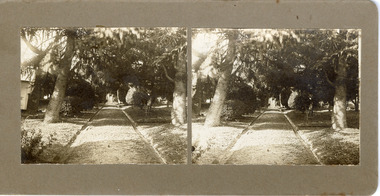 The Beechworth Burke Museum
Photograph - Stereoscopic Photograph, c1900
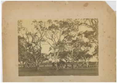
The gardens of Ovens District Hospital were laid out and planted by R H Jenkyns in 1874. Over 200 species of trees and shrubs were planted, including several large Himalayan Cedars (Cedrus deodora), a Coast Redwood (Sequoia sempervirens), rare Scots Pine (Pinus sylvestris), Pencil Cedar (Juniperus virginiana), Bunya Bunya Pines (Araucaria bidwillii), a Purple-leaved Dutch Elm (Ulmus x hollandica 'Purpurascens'), American Ash (Fraxinus americana), Pinus radiata, and numerous Populus alba trees and suckers. The gardens were considered integral to the healing process, also including orchards and kitchen gardens. In the 1880s, tourists flocked to Beechworth as the area became recognised as a health resort and picturesque beauty spot. Although the hospital closed in 1940, and parts were subsequently demolished, the gardens remain and form part of the site's listing on the Victorian Heritage Register. This photograph is part of a collection of items held by the Burke Museum relating to Ovens District Hospital. At the time of being built, the Ovens District Hospital was the only hospital between Melbourne, Victoria, and Goulburn, New South Wales, treating patients from all of north-east Victoria, including Indigo Shire.Black and white stereoscopic photograph mounted on card.Reverse: 97-2292 / View up centre path of Hospital / A03177 / BMM3177 / Note: A03178 / View of the central path of the Ovens Hospital / (Church St) Beechworthovens hospital, hospital garden, gardens and parks, ovens district hospital -
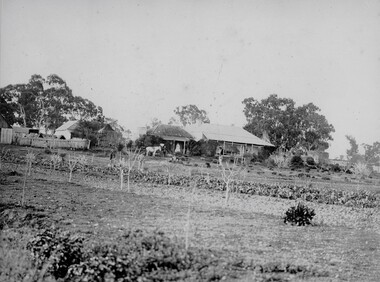
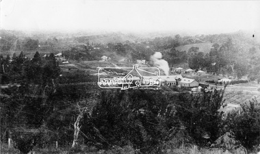 Eltham District Historical Society Inc
Negative - Photograph, Cool Stores, Hurstbridge, 1917
View overlookng Hurstbridge with the Cool Stores complex in the middle of the view (opened in March 1915) surrounded by an orchard of fruit trees. Local orchardists housed their fruits in cold storage here before despatch by rail to domestic and international markets, sometimes out of season.This photo forms part of a collection of photographs gathered by the Shire of Eltham for their centenary project book, "Pioneers and Painters: 100 years of the Shire of Eltham" by Alan Marshall (1971). The collection of over 500 images is held in partnership between Eltham District Historical Society and Yarra Plenty Regional Library (Eltham Library) and is now formally known as 'The Shire of Eltham Pioneers Photograph Collection.' It is significant in being the first community sourced collection representing the places and people of the Shire's first one hundred years.Digital image 4 x 5 inch B&W Negshire of eltham pioneers photograph collection, hurstbridge, cool stores, orchards, cool store -
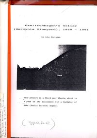 Bendigo Historical Society Inc.
Book - STRAUCH COLLECTION: GREIFFENHAGENS CELLAR (HERCYNIA VINEYARD)
"Hercynia" was the largest vineyyard in the Bendigo District. It was started by Carl Wilhelm Greiffenhagen (William) and his cousins, twins, Carl and August Heine. The first vine cuttings were planted in 1860. The partners owned 300 acres at Axe Creek and in 1862 had 24 acres under vines and an orchard of 4 acres. By 1884 they had expanded to 30 acres of vines. They produced many award winning wines. August Heine ( 1832 - 1898) was born in Germany and came to Australia in 1854 with his twin brother Carl and their cousin William Greiffenhagen. Initially the three took up mining successfully but then the partnership bought 300 acres at Axe Creek and planted a vineyard. They also grew fruit and crops to feed the working horses. In 1870 August sold his interest in the vineyard and set up his own smaller vineyard at Sheepwash Gully. He had several business interests before he took up the caretaker position at the newly dug Weeroona lake, a position he held until his death. Carl Heine sold his interest in the vineyard in 1873 and returned to Germany. WIlliam Grieffenhagen (1834-1916) continued his very successful vineyard until the region was hit with a highly infectious vine disease in 1893. Although his own vines escaped infection, he was within the 2 mile quarantine area and was forced to dig out all his vines. He never replanted but depended on his orchard instead. He was a founding member of the Bendigo Agricultural Society and a local Shire councillor for several years. In 1870 he married Margaret Boyd.Binder containing information relating to Greiffenhagen's cellar (Hercynia Vineyard) 1860 - 1991 including black and white photographs & maps, compiled by John Houlahan as a third year thesis whichnis pat of the assessment for a Bachelor of Arts (Social Science) degree. Donated to the German Society 15/2/96 by the Grandfather of author Jack Houlahan.John Houlahanbook, bendigo, wineries, bendigo-history-axe creek- wineries- german -
 Stawell Historical Society Inc
Photograph, "Allanvale" Home Station in Great Western 1866
Allanvale Home Station. Part of a collection of Photographs by Mr. O.G. Armstrong as commissioned by the Shire of Stawell for the Inter-colonial and Paris Exhibition in Melbourne in 1866. Allanvale was taken up about 1841 by John Allen, who was the son of George Allan of Allanvale, near Launceston in Van Diemen's Land. He selected 80,000 acres between present day Stawell and Ararat. The property was gradually reduced in size, with the first split occurring in the 1840s with the annexation of Concongella Selection due to a land dispute. J.S. Davidson was the occupier of Allanvale at the time this photograph was taken. The homestead pictured here was destroyed by fire at the end of the First World War and replaced by a new building around 1923. The present owners of Allanvale are the Kilpatrick family A note on the Allan family. On the 15th of March 1845, John Allen's 26 year old wife died at the birth of their third child, a daughter, who also died several weeks later. Elizabeth Allen had been a dear friend of Mrs Horatio Wills of neighbouring Lexington station. Eliza and her daughter were buried side by side in the garden of Lexington homestead. She was said to have been the first white woman to have died in the district. Homestead and stables on left with people on verandah and orchard in foreground.stawell great western -
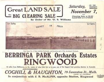 Ringwood and District Historical Society
Pamphlet - Auction Sale, Berringa Park Orchards Estate, Ringwood, Victoria - 1914
Multi-fold brochure advertising public auction of 37 lots on Saturday 7th November, 1914. Brochure includes terms of sale, description of subdivision features and local facilities, and photographic images of the area. Three-page Park Orchards Estate Price List attached.Subdivison includes Smedley Road, Oban Road, Berringa Road, and Williams Road, North Ringwood. Auctioneers: Coghill & Haughton, 79 Swanston Street, Melbourne, in conjunction with J.G. McAlpin, Ringwood. Brochure includes Clearing Sale to be held same day for "everything required to work these orchards, from a packing needle to a traction engine ... comprising the most up-to-date and extensive farm & chaffcutting plant in this great district". -
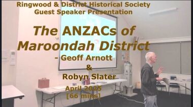 Ringwood and District Historical Society
Mixed media - Video, RDHS Meeting Presentation - "The ANZACs of Maroondah District" - Geoff Arnott and Robyn Slater
Digitised video (2.75GB). Duration: 66 minutes. Recorded April, 2025 (Video is available for viewing at Ringwood & District Historical Society Archives by appointment)In this timely 2-part presentation just prior to ANZAC Day, Geoff Arnott, Croydon Historical Society President, gives a talk on those who served in WW1 and came from the Maroondah area, and Robyn Slater summarises her book on Wonga Park Diggers in World War 1 from Orchards to Trenches. -
 Ringwood and District Historical Society
Mixed media - Video, RDHS Meeting Presentation - "Wonga Park ANZACs" - Robyn Slater
Digitised video (232mb). Duration: 5 minutes. Recorded April, 2025 (Video is available for viewing at Ringwood & District Historical Society Archives by appointment)In this timely presentation just prior to ANZAC Day, Robyn Slater summarises her book on Wonga Park Diggers in World War 1 from Orchards to Trenches. -
 Chelsea & District Historical Society Inc
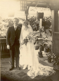
Photograph - Jean Brown And Francis Anderson, Wedding Photo, 1930
Zillah Jean Brown, known as Jean, was the daughter of Frederick Brown and the granddaughter of a pioneer of the district, Mr Hugh Brown. Jean married Francis Anderson in October 1930. Hugh Brown (1830-1930), born in Ireland, arrived in Adelaide in 1855 and in the Mordialloc district in 1856. Mr Brown brought land in 1866 and built his farmhouse “Pine Vale” in 1870 near the site of the present Mordialloc Secondary College (then part of the property) and extended his property when the swampland was made open for selection in 1871. The property was a market garden and orchard. Hugh Brown married Zillah Baxter (1866) and they had six sons, five living to adulthood. The Brown family increased their land holding until they held a major part of the farmland between Mordialloc Creek to almost the Aspendale Railway Station. The property was a market garden and orchard. Mr Brown took an active interest in the public life of the community, a Justice of the Peace; Councillor of Dandenong Shire for over 30 years, was twice Shire President; and a founding member of the Mordialloc Mechanics Institute. Black and white studio photo of the wedding of Miss Jean Brown and Mr Francis Anderson on the verandah of the house.The Yeoman Studioshugh brown, mordialloc, jean brown, zillah brown, francis anderson, wedding -
 Chelsea & District Historical Society Inc
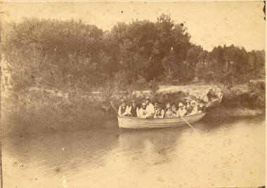
Photograph - The Brown Family, Boat Trip, 1882
The members of the Brown family in a rowing boat on Mordialloc Creek. Hugh Brown (1830-1930), born in Ireland, arrived in Adelaide in 1855 and in the Mordialloc district in 1856. Mr Brown brought land in 1866 and built his farmhouse “Pine Vale” in 1870 near the site of the present Mordialloc Secondary College (then part of the property) and extended his property when the swampland was made open for selection in 1871. The property was a market garden and orchard. Hugh Brown married Zillah Baxter (1866) and they had six sons, five living to adulthood. The Brown family increased their land holding until they held a major part of the farmland between Mordialloc Creek to almost the Aspendale Railway Station. The property was a market garden and orchard. Mr Brown took an active interest in the public life of the community, a Justice of the Peace; Councillor of Dandenong Shire for over 30 years, was twice Shire President; and a founding member of the Mordialloc Mechanics Institute. Sepia photo of a adults in a large rowing boat on Mordialloc Creek, Mordialloc.hugh brown, mordialloc, pioneer, pine vale, mordialloc creek, row boat -
 Chelsea & District Historical Society Inc
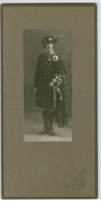
Photograph - Jean Brown, Highland Dress, 1924
Zillah Jean Brown, known as Jean, was the granddaughter of a pioneer of the district, Mr Hugh Brown. Hugh Brown (1830-1930), born in Ireland, arrived in Adelaide in 1855 and in the Mordialloc district in 1856. Mr Brown brought land in 1866 and built his farmhouse “Pine Vale” in 1870 near the site of the present Mordialloc Secondary College (then part of the property) and extended his property when the swampland was made open for selection in 1871. The property was a market garden and orchard. Hugh Brown married Zillah Baxter (1866) and they had six sons, five living to adulthood. The Brown family increased their land holding until they held a major part of the farmland between Mordialloc Creek to almost the Aspendale Railway Station. The property was a market garden and orchard. Mr Brown took an active interest in the public life of the community, a Justice of the Peace; Councillor of Dandenong Shire for over 30 years, was twice Shire President; and a founding member of the Mordialloc Mechanics Institute. Black and white photo of Miss Jean Brown in highland dress with bagpipes.University Studios 306 Lygon St. Carltonhugh brown, mordialloc, jean brown, highland dress, costumes, bagpipes -
 Chelsea & District Historical Society Inc
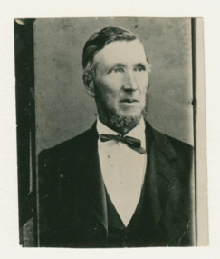
Photograph - Mr Hugh Brown, early 1900's
Hugh Brown (1830-1930), born in Ireland, arrived in Adelaide in 1855 and in the Mordialloc district in 1856. Mr Brown brought land in 1866 and built his farmhouse “Pine Vale” in 1870 near the site of the present Mordialloc Secondary College (then part of the property) and extended his property when the swampland was made open for selection in 1871. The property was a market garden and orchard. Hugh Brown married Zillah Baxter (1866) and they had six sons, five living to adulthood. The Brown family increased their land holding until they held a major part of the farmland between Mordialloc Creek to almost the Aspendale Railway Station. The property was a market garden and orchard. Mr Brown took an active interest in the public life of the community, a Justice of the Peace; Councillor of Dandenong Shire for over 30 years, was twice Shire President; and a founding member of the Mordialloc Mechanics Institute. Black and white photo of Mr Hugh Brown.hugh brown, mordialloc, pioneer, market gardener, farmer, pine vale -
 Chelsea & District Historical Society Inc
Photograph - Mr Hugh Brown's Farm, "Pine Vale", c 1865
Mr Hugh Brown farm, collecting logs for fence and preparing the ground to grow fruit trees. Mr Brown planted 8 acres of fruit trees. Hugh Brown (1830-1930), born in Ireland, arrived in Adelaide in 1855 and in the Mordialloc district in 1856. Mr Brown brought land in 1866 and built his farmhouse “Pine Vale” in 1870 near the site of the present Mordialloc Secondary College (then part of the property) and extended his property when the swampland was made open for selection in 1871. The property was a market garden and orchard. Hugh Brown married Zillah Baxter (1866) and they had six sons, five living to adulthood. The Brown family increased their land holding until they held a major part of the farmland between Mordialloc Creek to almost the Aspendale Railway Station. The property was a market garden and orchard. Mr Brown took an active interest in the public life of the community, a Justice of the Peace; Councillor of Dandenong Shire for over 30 years, was twice Shire President; and a founding member of the Mordialloc Mechanics Institute. Black and white studio photo of Mr Hugh Brown's farm. Gum trees and cleared land.hugh brown, mordialloc, pioneer, pine vale, farm, orchard, fruit trees, cattle, wagon track, fence -
 Chelsea & District Historical Society Inc
Photograph - Zillah Brown, c 1860's
Zillah Brown (nee Baxter), was the wife of a pioneer of the district, Mr Hugh Brown. Hugh Brown (1830-1930), born in Ireland, arrived in Adelaide in 1855 and in the Mordialloc district in 1856. Mr Brown brought land in 1866 and built his farmhouse “Pine Vale” in 1870 near the site of the present Mordialloc Secondary College (then part of the property) and extended his property when the swampland was made open for selection in 1871. The property was a market garden and orchard. Hugh Brown married Zillah Baxter (1866) and they had six sons, five living to adulthood. The Brown family increased their land holding until they held a major part of the farmland between Mordialloc Creek to almost the Aspendale Railway Station. The property was a market garden and orchard. Mr Brown took an active interest in the public life of the community, a Justice of the Peace; Councillor of Dandenong Shire for over 30 years, was twice Shire President; and a founding member of the Mordialloc Mechanics Institute. Black and white studio photo of Mrs Zillah Brown and her son.University Studios 306 Lygon St. Carltonhugh brown, mordialloc, pioneer, zillah brown, zillah baxter, pine vale -
 Chelsea & District Historical Society Inc
Photograph - Jean Brown, 1918
Zillah Jean Brown, known as Jean, was the granddaughter of a pioneer of the district, Mr Hugh Brown. Hugh Brown (1830-1930), born in Ireland, arrived in Adelaide in 1855 and in the Mordialloc district in 1856. Mr Brown brought land in 1866 and built his farmhouse “Pine Vale” in 1870 near the site of the present Mordialloc Secondary College (then part of the property) and extended his property when the swampland was made open for selection in 1871. The property was a market garden and orchard. Hugh Brown married Zillah Baxter (1866) and they had six sons, five living to adulthood. The Brown family increased their land holding until they held a major part of the farmland between Mordialloc Creek to almost the Aspendale Railway Station. The property was a market garden and orchard. Mr Brown took an active interest in the public life of the community, a Justice of the Peace; Councillor of Dandenong Shire for over 30 years, was twice Shire President; and a founding member of the Mordialloc Mechanics Institute. Black and white studio photo of Miss Jean Brown with a doll.The Yeoman Studioshugh brown, mordialloc, jean brown, zillah brown, doll -
 Chelsea & District Historical Society Inc
Photograph - Jean Brown And Francis Anderson, Group Wedding Photo, 1930
From Left to Right: Margaret Watson, Hugh Brown, Frank Anderson, Jean Brown, Mary Anderson, Bill Armstrong Zillah Jean Brown, known as Jean, was the granddaughter of a pioneer of the district, Mr Hugh Brown. Jean married Francis Anderson in October 1930. Hugh Brown (1830-1930), born in Ireland, arrived in Adelaide in 1855 and in the Mordialloc district in 1856. Mr Brown brought land in 1866 and built his farmhouse “Pine Vale” in 1870 near the site of the present Mordialloc Secondary College (then part of the property) and extended his property when the swampland was made open for selection in 1871. The property was a market garden and orchard. Hugh Brown married Zillah Baxter (1866) and they had six sons, five living to adulthood. The Brown family increased their land holding until they held a major part of the farmland between Mordialloc Creek to almost the Aspendale Railway Station. The property was a market garden and orchard. Mr Brown took an active interest in the public life of the community, a Justice of the Peace; Councillor of Dandenong Shire for over 30 years, was twice Shire President; and a founding member of the Mordialloc Mechanics Institute. Black and white studio photo of the wedding party of Miss Jean Brown and Mr Francis Anderson.hugh brown, mordialloc, jean brown, zillah brown, francis anderson, wedding, margaret watson, mary anderson, bill armstrong -
 Chelsea & District Historical Society Inc
Photograph - The Brown Family, Alexander Brown
Alexander Brown (known as Alex) (1863 - 1940), is the fourth son of Hugh Brown, a pioneer of the district. Hugh Brown (1830-1930), born in Ireland, arrived in Adelaide in 1855 and in the Mordialloc district in 1856. Mr Brown brought land in 1866 and built his farmhouse “Pine Vale” in 1870 near the site of the present Mordialloc Secondary College (then part of the property) and extended his property when the swampland was made open for selection in 1871. The property was a market garden and orchard. Hugh Brown married Zillah Baxter (1866) and they had six sons, five living to adulthood. The Brown family increased their land holding until they held a major part of the farmland between Mordialloc Creek to almost the Aspendale Railway Station. The property was a market garden and orchard. Mr Brown took an active interest in the public life of the community, a Justice of the Peace; Councillor of Dandenong Shire for over 30 years, was twice Shire President; and a founding member of the Mordialloc Mechanics Institute. Sepia studio photo of Mr Alexander BrownYeoman Co. Bourke St. Melbournehugh brown, mordialloc, pioneer, zillah brown, zillah baxter, pine vale, alex brown, alexander brown, fred brown, frederick brown -
 Chelsea & District Historical Society Inc
Photograph - The Brown Children, 1910
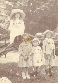
Doris, Alex, George and Jean are the grandchildren of Mr Hugh Brown. Hugh Brown (1830-1930), born in Ireland, arrived in Adelaide in 1855 and in the Mordialloc district in 1856. Mr Brown brought land in 1866 and built his farmhouse “Pine Vale” in 1870 near the site of the present Mordialloc Secondary College (then part of the property) and extended his property when the swampland was made open for selection in 1871. The property was a market garden and orchard. Hugh Brown married Zillah Baxter (1866) and they had six sons, five living to adulthood. The Brown family increased their land holding until they held a major part of the farmland between Mordialloc Creek to almost the Aspendale Railway Station. The property was a market garden and orchard. Mr Brown took an active interest in the public life of the community, a Justice of the Peace; Councillor of Dandenong Shire for over 30 years, was twice Shire President; and a founding member of the Mordialloc Mechanics Institute. Black and white studio photo of the Brown children standing on a tee-tree in Attenbourgh Park, Mordialloc.Doris, Alex, Jean, Georgehugh brown, mordialloc, jean brown, zillah brown, doris brown, alex brown, attenbourgh park -
 Chelsea & District Historical Society Inc
Photograph - The Brown Family, Frederick and Alexander
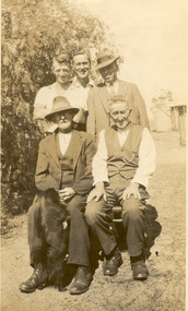
Seated - Frederick Brown (known as Fred) (1860-1959) and Alexander Brown (known as Alex) (1863 - 1940), are the sons of Hugh Brown, a pioneer of the district. Hugh Brown (1830-1930), born in Ireland, arrived in Adelaide in 1855 and in the Mordialloc district in 1856. Mr Brown brought land in 1866 and built his farmhouse “Pine Vale” in 1870 near the site of the present Mordialloc Secondary College (then part of the property) and extended his property when the swampland was made open for selection in 1871. The property was a market garden and orchard. Hugh Brown married Zillah Baxter (1866) and they had six sons, five living to adulthood. The Brown family increased their land holding until they held a major part of the farmland between Mordialloc Creek to almost the Aspendale Railway Station. The property was a market garden and orchard. Mr Brown took an active interest in the public life of the community, a Justice of the Peace; Councillor of Dandenong Shire for over 30 years, was twice Shire President; and a founding member of the Mordialloc Mechanics Institute. Sepia studio photo of five men, three younger men standing behind two sitting.hugh brown, mordialloc, pioneer, zillah brown, zillah baxter, pine vale, alex brown, alexander brown, fred brown, frederick brown -
 Chelsea & District Historical Society Inc
Photograph - Mr Hugh Brown's Farm, A game of cricket
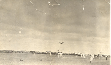
A cricket game in the paddocks of Mr Hugh Brown farm. Hugh Brown (1830-1930), born in Ireland, arrived in Adelaide in 1855 and in the Mordialloc district in 1856. Mr Brown brought land in 1866 and built his farmhouse “Pine Vale” in 1870 near the site of the present Mordialloc Secondary College (then part of the property) and extended his property when the swampland was made open for selection in 1871. The property was a market garden and orchard. Hugh Brown married Zillah Baxter (1866) and they had six sons, five living to adulthood. The Brown family increased their land holding until they held a major part of the farmland between Mordialloc Creek to almost the Aspendale Railway Station. The property was a market garden and orchard. Mr Brown took an active interest in the public life of the community, a Justice of the Peace; Councillor of Dandenong Shire for over 30 years, was twice Shire President; and a founding member of the Mordialloc Mechanics Institute. Black and white studio photo of a cricket game in the paddock Mr Hugh Brown's farm. Farm houses and sheds in the background. A biplane flying overhead.hugh brown, mordialloc, pioneer, pine vale, farm, cricket, biplane, paddock, farm house -
 University of Melbourne, Burnley Campus Archives
Album - Colour prints, negatives and 35mm slides, Staff, Collection of Photographs Used by Staff, 1994-2000
Collection of photographs in envelopes which had belonged to staff members. Some are photographs from excursions, others are teaching material, plants. Some labelled: 1. Ruth Upper Merri Creek - negatives and prints; Merri Creek - negatives and prints; Merri Creek Panorama - prints; Merri Creek Posters 1995 - negatives and prints; Plants - negatives. 2. Western District Exhibition, labelled - negatives and prints of paintings; Mt Ridley (Excursion?) - negatives and prints; Energy Education Centre 15 November 1995; Gardens - Spring 1995 negatives (mostly James Hitchmough, Native Grasslands and Luffmann Ponds) Scanned; Student Party June 1994 - negatives; 3. Pot Trial - negatives and prints; Miscellaneous plant trials, Centenial Centre Shop, Arborists, Plants, Excursions - negatives; Excursions , 1 year 2000 - negatives and prints; Orchard (older) - black and white negatives and prints; Arborists - negatives and prints; 4. Staff, Graduate students - negatives and prints; Miscellaneous: Plants, - negatives, slides and prints. 7. Native Garden and other garden views - prints and negativesstaff, excursions, teaching material, merri creek, mt ridley, energy education centre, student party, pot trial, centenial centre shop, arborists, plants, graduates, students, plant database, jill kellow, orchard, james hitchmough grasslands, horticulture shop, ruth beilin, upper merri creek, merri creek panorama, merri creek posters