Showing 2735 items
matching otway-reef
-
 Bendigo Historical Society Inc.
Book - DEPARTMENT OF MINES 1914 BULLETINS OF THE GEOLOGICAL SURVEY OF VICTORIA NO. 33. HUSTLER'S LINE OF REEF, BENDIGO, 1914
Department of Mines 1914 Bulletins of the Geological Survey of Victoria No. 33. Hustler's Line of Reef, Bendigo. Photos of the mines on the Hustler's Line of Reef. 59 pages plus 7 pages of photos. Inscribed A. Richardson 29 Harrison street, BendigoDepartment of Mines.bendigo, mining, hustler's line of reef, mining, and hustler's reef mines. -
 Bendigo Historical Society Inc.
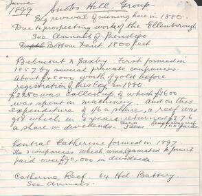
Document - SNOB'S HILL - NOTES ON THE SNOB'S HILL GROUP
Handwritten notes and typed copy on history, production, Calls, Dividends and area of lease of Snob's Hill group of mines. Mines mentioned: Belmont and Saxby, Central Catherine Reef G.M. and Catherine Reef G.M. Notes prepared by Albert Richardson.document, gold, snob's hill, snob's hill, notes on snob's hill group, ellenborough, annals of bendigo, belmont & saxby, central catherine, catherine reef -
Glenelg Shire Council Cultural Collection
Letter - Invitation and Envelope - Photographic Archive Project Casterton 1986, n.d
a. Invitation from Shire of Glenelg president to Mrs. B. Vivian, to official opening of the Photographic Archive Project being held in Casterton from 3 - 21 March 1986. White card, gold Shire of Glenelg logo, black print. Invitation folded in half. b, Envelope containing the invitation. white, red, Shire of Glenelg stamp, Casterton Post Office date stamp, Aust. Post red franking stampFront: 'Mrs. B. Vivian, 22 Otway Street, PORTLAND, 3305' - black script Back: Shire of Glenelg gold logo on flap -
 Port Melbourne Historical & Preservation Society
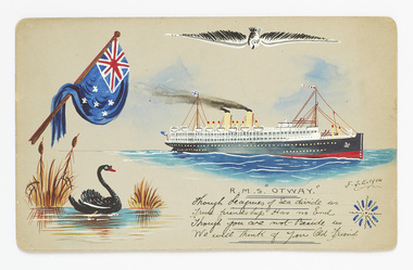
Card - Bon Voyage, 1914
From the Smallpage family collection, donated by Ann SmallpageBon voyage card 1914, hand painted onto smooth, round-cornered, grey cardboard by 'F.J.E.', depicting the Australian flag, a black swan, a seagull, R.M.S. Otway under sail and a decorative device. Handwritten sentimentHandwritten "Though Leagues of Sea divide us / True friendship has no end Though you are not beside us / we will think of you Old Friend"transport - shipping, arts and entertainment - visual arts, rms otway, painting -
 Otway Districts Historical Society
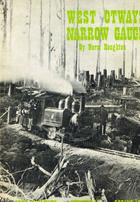
Book, West Otways Narrow Gauge; Norman Houghton, Spring 1973
West Otways Narrow Gauge; The story of the Beech Forest 2ft 6in gauge railway and its connecting tramways; Norman Houghton; Light Railways v.XII, no.45, Spring 1973; soft cover; 52p.; illus. mapsPrinting - Kemera Press, Caulfield, Vic.west otways; narrow gauge; beech forest; 2ft 6in narrow gauge; tramways; colac; gellibrand; the ridge; crowes; -
 Otway Districts Historical Society
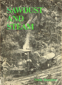
Book, Light Railway Research Society of Australia, Sawdust and Steam. Norman Houghton, December 1975
Sawdust and steam. A history of the railways and tramways of the eastern Otway Ranges. Norman Houghton. IBSN 0 909340 03 X. Soft cover. iv, 106 p.; illus, maps. Melbourne, 1975. Cartography: Alan Strempel.steam and society; norman houghton; railways, east otways; tramways, east otways; tramways, forrest; coastal tramways; -
 Otway Districts Historical Society
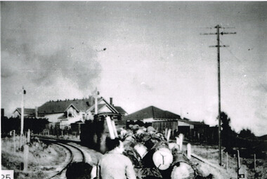
Photograph, Beech Forest: train from Crowes arrives
B/W. A train from Crowes laden with timber passes the twin home signals on its way into Beech Forest. Two men are in the foreground. Otway Shire offices (now defunct) and the Shire Secretary's house are in the background.beech forest; railways; -
 Otway Districts Historical Society
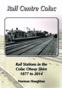
Book, Norman Houghton, Rail Centre Colac, 2014
Colac was the centre of a spidery rail network over which were carted anything and everything by Victorian Railways, the common carrier throughout the area. The main line through the region was the 35 km rail route from Birregurra (and thence to Geelong) though Colac to Pirron Yallock (and thence to Warrnambool and Port Fairy) from March, 1877, to July, 1883. The first branch line ran from Irrewarra to Beeac in 1889, which then extended in stages to Cressy and on the Ballarat. The second branch line was the 31 km long Birregurra to Forrest in 1891. The cost of building railways into mountainous terrain meant the third branch line was a narrow-gauge 2 foot 6 inch line, first of all to Beech Forest in 1902, and then to Crowes in 1911, for a total of 71 km. The final rail connection was the 16 km branch from Colac to Alvie to facilitate the transport of onions, opening in 1923. Each line had its own character and peculiarities derived from its foundation, geography and economic base. As a general rule, the loadings on the branch lines had greater output tonnage than inwards, the reverse of the main line. The lines traversed agricultural and timber areas where inputs like seed, grass, fertiliser and labour were minor, compared with the output, timber, wool, cream, butter, cheese fruit, potatoes, onion, grain and livestock.Rail Centre Colac. Rail stations in the Colac Otway Shire, 1877 to 2014. Norman Houghton. 1st ed. Norman Houghton; Geelong (Vic); 2014. vi, 262 p.; illus., maps, index. Soft cover.colac; cressy; forrest; beech forest; crowes -
Bendigo Historical Society Inc.
Document - Hustlers Line of Reef, Bendigo, South Portion, April, 2014
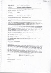
Seven men were killed at the Great Extended Hustler's mine disaster on 2nd May 1914 by an explosion of dynamite occurring as the men were waiting at the plat to ascend the mine at the end of their shift. No blame was attached to anyone in the findings of the inquisition. It was unknown what caused the dynamite to explode. This document formed part of the research done at the time by Bendigo Historical Society, of the 100 years commemoration of the mine disaster, held at Hustler's Hill in 2014. One page photocopy of plan of mining leases on the south portion of the Hustlers Line of Reef. Written underneath plan 'Wood & McNair, Sharebrokers, Beehive Chambers, Bendigo'. Fortuna Hustlers Co., Hustlers Royal Reserve No 2; Great Extended Hustlers Co., Hustlers Reef Co., Hustlers Reef No. 1 and United Hustlers & Redan Co. showing shares held and length of lease are listed on page. great extended hustlers, goldmining, accident, 1873 -
 Bendigo Historical Society Inc.
Document - Hustlers Line of Reef, Bendigo, South Portion, April, 2014
Seven men were killed at the Great Extended Hustler's mine disaster on 2nd May 1914 by an explosion of dynamite occurring as the men were waiting at the plat to ascend the mine at the end of their shift. No blame was attached to anyone in the findings of the inquisition. It was unknown what caused the dynamite to explode. This document formed part of the research done at the time by Bendigo Historical Society, of the 100 years commemoration of the mine disaster, held at Hustler's Hill in 2014. One page photocopy of plan of mining leases on the south portion of the Hustlers Line of Reef. Written underneath plan 'Wood & McNair, Sharebrokers, Beehive Chambers, Bendigo'. Fortuna Hustlers Co., Hustlers Royal Reserve No 2; Great Extended Hustlers Co., Hustlers Reef Co., Hustlers Reef No. 1 and United Hustlers & Redan Co. showing shares held and length of lease are listed on page. great extended hustlers, goldmining, accident, 1873 -
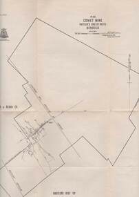
 Bendigo Historical Society Inc.
Map - UNITED HUSTLER'S & REDAN & K. K. MINES - PLAN OF UNITED HUSTLER'S & REDAN & K. K. MINES
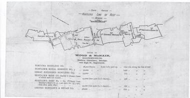
Plan of the United Hustler's & Redan & K. K. Mines on the Hustler's Line of Reefs Bulletin No 33 Plate No XXVII. Plan shows depth of levels, Long Gully, Hustler's Line of Reefs, Lightning Hill Line of Reefs and approximate Boundary of Lease. Also mentions Comet Co. Geological Survey of Victoria emblem and signed by H S Whitelaw, Underground Survey Office Bendigo September 1913.mining, parish map, united hustler's & redan & k. k. mines, long gully, hustler's line of reefs, lightning hill line of reefs, comet co, h s whitelaw, geological survey of victoria, underground survey office -
 Bendigo Historical Society Inc.
Document - STAFFORD REEF MINE SITE, DIAMOND HILL
One page document describing the Stafford Reef Mine Site, Diamond Hill, Site 4.11, prepared by David Bannear. Information includes the map/grid references of the site and an overview of the history of the Stafford Reef Mine. The physical remains of the mine are described..bendigo, mining, stafford reef mine -
 Bendigo Historical Society Inc.
Document - REEFS AND SPURS ON BENDIGO GOLDFIELD
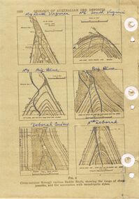
Three pages of information (copied ) regarding reefs and spurs on Bendigo Goldfield. Page 1020 'Geology of Australian ore deposits', drawings labelled in blue biro: No 19 level Virginia Mine, No 6 level South Virginia; No 9 level, Big blue, Big Blue, Deborah Cons'ted ( consolidated?) North Deborah. On bottom ' cross sections through various saddle reefs, showing the range of shape possible, and the association with monchiquite dykes' Page 1021 ( cont) Virginia South Extended; 3000ft New Chum Rly; Catherine Reef, Spurs in Carlisle. On bottom ' Cross sections through a trough reef, 'double' saddle reef and spurry systems. Final page: mines listed and descriptions of workings: Golden Age, Johnson's Reef Extended, Golden Pyke, Constellation, Great Northern, Virginia, Specimen Hill United, New Argus, Clarence United, North Argus, South New Moon.bendigo, mining, reefs and spurs -
Federation University Historical Collection
Photograph, Tim Reed of Verus Testing Solutions
Tim Reef shows new softwsre solutionsat the Greenhill Enterprise Centre, Ballarat Technology Park.tim reed, verus testings solutions, greenhill enterprise centre, ballarat technology centre -
 Federation University Historical Collection
Map - Geological survey, Parish of Cardigan, County of Grenville, c1889
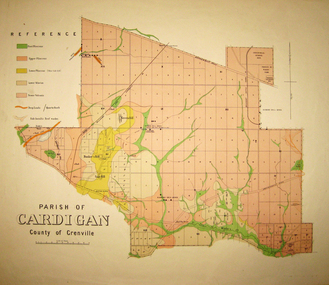
Geological map of the Parish of Cardigan on a cadastral base showing quartz reefs, shafts, alluvial deposits.cardigan, winter's creek, ballarat cattle yards railway, prince of wales park, ballarat, friendly societies reserve, ballarat industrial school reserve, green hill, bunker's hill, sago hill, diamond drill bores, cardigan propriety, half way house, ti tree creek, albion consols, prince imperial, winter's freehold company -
 Federation University Historical Collection
Plan, Parish of Dowling Forest, County of Ripon and Grenville, 19
Scale [1:31 680]. 40 chains to 1 in.Geological map on a cadastral base, showing the occurence of reefs, and alluvial deposits. Relief shown by contours.dowling forest, wyndholm, wyndholm pre-emptive right, miners rest, ballarat racecourse, winter's swamp, police reserve, miner's rest, winters swamp, geology -
 Bendigo Historical Society Inc.
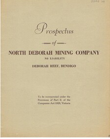
Document - MCCOLL, RANKIN AND STANISTREET COLLECTION: NORTH DEBORAH MINING COMPANY NL DEBORAH REEF, 17th. April 1937
Document: gray booklet ' Prospectus of North Deborah Mining Company NL, Deborah Reef Bendigo.Carter & Taverner Pty. Ltd., Print. Melbourneorganization, mining, north deborah mining company, mccoll, rankin and stanistreet, north deborah mining company, goldmining, prospectus -
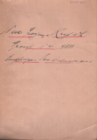 Bendigo Historical Society Inc.
Document - MCCOLL, RANKIN AND STANISTREET COLLECTION: NELL GWYNNE REEF N/L - GROUP NO. 9311 EMPLOYEE TAX DEDUCTIONS, 1947 - 1950
Document. 3/4 size tan folder, hand written title Nell Gwynne Reef.McColl, Rankin & Stanistreetorganization, business, nell gwynne reef mine, mccollm rankin & stanistreet, nell gwynne mine, gold mining, employee tax deductions. -
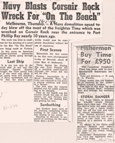 Queenscliffe Maritime Museum
Mixed media - Wreck of the TIME, News articles re the wreck of the TIME, c1949 newspapers
Shipwreck & rescueSS TIME wreck, Corsair Reef & Queenscliffe Lifeboat.News articles, photos, map & report re SS TIME wreck at Corsair Reef c1949Reverse " NIL ".historical references -
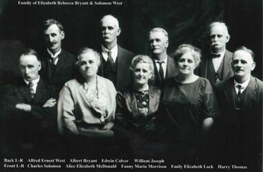 Phillip Island and District Historical Society Inc.
Photograph, Family Photographs and Back to Phillip Island
1041-01 Family of Elizabeth Rebecca Bryant & Solomon West - family identified c1924 - ?? 1926 1041-02 Back to Phillip Island c 1924. People identified in 1989 by Mrs Beth Freeman, daughter of William Otway MorrisonHistorical1041-01 Photograph: Family of Elizabeth Rebecca Bryant & Solomon West 1041-02 Photograph: Back to Phillip Island c 1924 with names1041-01: Family of Elizabeth Rebecca Bryant & Solomon West Back L-R Alfred Ernest West, Albert Bryant, Edwin Calver, William Joseph Front L-R Charles Solomon, Alice Elizabeth McDonald, Fanny Maria Morrison, Emily Elizabeth Lock, Harry Thomas 1041-02: Back to Phillip Island c.1924 Identification 1989, Mrs Beth Freeman daughter of William Otway Morrison Front L-R 1. Dan Morrison 2. Ted West 3. Norman McDonald 4. William West s/o Solomon 5. ? 6. William Otway Morrison Second Row L-R 1.? 2. Miriam West Henderson d/o John 3. ? 4. Emily West Lock d/o Solomon 5. ? 6. Fanny West Morrison w/o No. 6 above, d/o Solomon 7. Child to 10 (man with pipe) not identified Back Row L-R 1 to 5 not identified 6. Albert West, s/o Solomon 7. Marion Somerville West 8. Janet Morrison w/o Wm West (obscured) 9. Harry Brown 10. Nell West Brown d/o William West 11-13 unidentified 14. Alice West McDonald d/o Solomon 15. Jenny?west, back to phillip island c1924, morrison family, bryant, solomon -
 Bendigo Historical Society Inc.
Map - STRUGNELL COLLECTION: HUSTLER'S LINE OF REEFS, BENDIGO
Map, Hustler's Line of Reefs, Comet Mine, Plan, Plate No. XX111 (23).Lightning Hill Anticline at Surface, United Hustler's & Redan Co., Hustler's Reef Co..Bulletin No 33 Signed H.A.Whitelaw Underground survey Office Bendigo September 1913Underground Survey Office, Bendigo. -
 Bendigo Historical Society Inc.
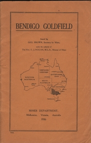
Book - BENDIGO GOLDFIELD
booklet, 51 pages. 'Bendigo Goldfield' issued by Geo Brown, Secretary for Mines. Mines Department 1936. Contains information on the geology of the Bendigo goldfield and major lines of reef and mines. Map of goldfield showing reef lines and mines attached to back cover.bendigo, mining, bendigo goldfield -
 Bendigo Historical Society Inc.
Map - Hustler's Line of Reef
Longitudinal section of Hustler's Reef & Hustler's Reef no. 1 mine. Plate XX, note plates 4,8,13,20, 26 & 31 form a longitudinal section from Fortuna Hustler's to Hustler's Consols Mine. produced by the underground survey office, Bendigo, September 1913.hustler's reef, bendigo goldfields, hustler's reef no.1 mine -
 Bendigo Historical Society Inc.
Map - HUSTLER'S REEF & HUSTLER'S REEF NO 1 MINES - PLAN OF THE HUSTLER'S REEF & HUSTLER'S REEF NO 1 MINES
Plan of the Hustler's Reef & Hustler's Reef No 1 Mines on the Hustler's Line of Reefs, Bendigo Bulletin No 33, Plate No XVI. Plan shows the two shafts and the levels in relation to it. No 9 Level 896 feet 9 inches connecting No 10 Level at 867 feet 2 inches. Plan shows depth of levels and geographical features. Signed by H A Whitelaw, Underground Survey Office, Bendigo. Geographical Survey of Victoria emblem.mining, parish map, hustler's reef & hustler's reef no 1 mines, hustler's line of reefs, h a whitelaw, underground survey office bendigo, geographical survey of victoria -
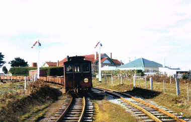 Otway Districts Historical Society
Photograph, Langford, Weston, Goods train arriving at Beech Forest, 1961, 9 August 1961
From late in 1960 VR took what were the first definite steps to close the Colac-Beech Forest line. 1,101 tonnes of freight per year flowed from Colac to Beech Forest because of increasing competition from the roads. From 1 July 1960 onwards, when pulpwood (hardwood) stopped being shipped from Beech Forest, a maximum of only 7,000 tonnes/year would be shipped to Colac. Including special trips passenger revenue earned a little more than $200 per annum. The issue of second-hand sleepers stopped entirely and the two track gangs only patrolled the track and tightened loose bolts. The line did not earn its way and on 4 November 1960 it was recommended that services over the narrow gauge line be discontinued.The rear of a goods train from Colac arrives at Beech Forest on 9 August 1961. The other line is the former Crowes line truncated at Weeaproinah in January 1955. In the background is the Beech Forest Hall and Shire of Otway offices. Colour.colac; beech forest; railway; -
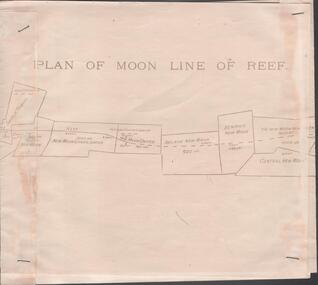 Bendigo Historical Society Inc.
Map - NEW MOON COMPANY, NO LIABILITY - PLAN OF THE MOON LINE 1906
Plan of the Moon Line of Reef 1906. Plan shows the line of reef and the leases with the distance along the reef. The Bendigo - Inglewood railway line is also drawn in. Leases mentioned are: Nth Johnsons, Johnson's Reef,Princess Dagman, Golden Age, Johnson's Reef Extd, Golden Pyke, Constellation, McDuff, Great Northern, Virginia, Specimen Hill, New Hopeful, New Argus, Clarence, North Argus, Moon, South New Moon, New Moon, Suffolk Tribute, North New Moon, New Moon Consolidated, New Moon United, Adelaide New Moon, Bendigo New Moon, The New Moon Northern Blocks, Central New Moon, Rising Moon, Full Moon, The Moon, Gt Extd New Moon, V Rymer.map, bendigo, goldfields, new moon company, no liability, plan of the moon line 1906, a richardson, nth johnsons, johnson's reef, princess dagman, golden age, johnson's reef extd, golden pyke, constellation, mcduff, great northern, virginia, specimen hill, new hopeful, new argus, clarence, north argus, moon, south new moon, new moon, suffolk tribute, north new moon, new moon consolidated, new moon united, adelaide new moon, bendigo new moon, the new moon northern blocks, central new moon, rising moon, full moon, the moon, gt extd new moon, v rymer. bendigo - inglewood railway -
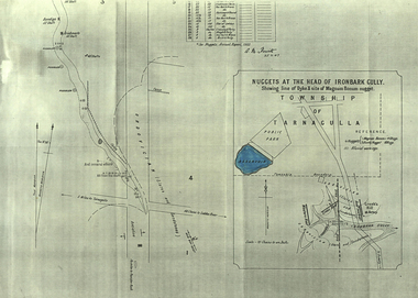 Federation University Historical Collection
Plan, A.M. Howitt, Nuggets at the Head of Ironbark Gully, Tarnagulla, c1907
Plan showing part of the township of Tarnagulla, and the Ironbark Gully area including Western Reef and Creek's Hill.tarnagulla, ironbark gully, western reef, creek's hill, cgt -
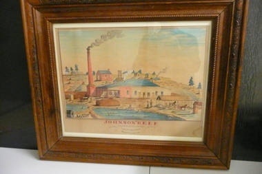 Bendigo Historical Society Inc.
Painting - JOHNSON'S REEF GOLD MINING COMP
Water colour painting of Johnson's Reef Gold Mining Camp California Gully Bendigo Victoria Australlia.organization, mining, johnsons reef -
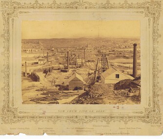 Bendigo Historical Society Inc.
Photograph - VIEWS OF BENDIGO: NEW CHUM LINE OF REEF, 1875
Sepia photograph of views of Sandhurst. Inscriptions: (on card) 'Views of Bendigo, No 2, New Chum Line of Reef.N J Caire, Sandhurstprevious acc. no. 'mp134'. see also 2001.392.01 and 2001.390.01 see 'views of bendigo' by n.j.caire -
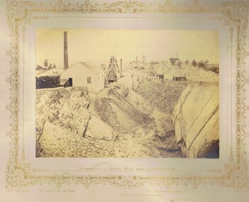 Bendigo Historical Society Inc.
Photograph - VIEWS OF BENDIGO: EXCAVATION OF QUARTZ REEF NEAR IRONBARK HILL, c. 1870s
Sepia toned photograph. Photograph No. 7: Excavation of Quartz Reef near ironbark hill (two copies)N.J. Cairetopic, mining, battery