Showing 841 items matching "parish plan"
-
 Bendigo Historical Society Inc.
Map - NERRING, 15/06/1937
... Map: Parish of Nerring, County of Bendigo. Parish plan..., County of Bendigo. Parish plan Canvas backed ( number 139 in Map ...Map: Parish of Nerring, County of Bendigo. Parish plan Canvas backed ( number 139 in Map Cupboard 1)map, bendigo, rural, nerring, county of bendigo -
Bendigo Historical Society Inc.
Map - RAYWOOD, 18/09/1930
... of Bendigo. Parish plan (number 270 in map cupboard 1)... of Neilborough,County of Bendigo. Parish plan (number 270 in map cupboard ...Map: Township of Raywood, Parish of Neilborough,County of Bendigo. Parish plan (number 270 in map cupboard 1)map, bendigo, township, raywood -
Bendigo Historical Society Inc.
Map - GOORNONG, 1/10/1906
... of Bendigo. Parish plan (number 269 in map cupboard 1)... of Goornong, County of Bendigo. Parish plan (number 269 in map ...Map: Town of Goornong, Parish of Goornong, County of Bendigo. Parish plan (number 269 in map cupboard 1)map, bendigo, township, goornong -
Bendigo Historical Society Inc.
Map - RAVENSWOOD, April 6th 1872
... Map: Township of Ravenswood. Parish plan, has a 1913... Bendigo township Ravenswood Map: Township of Ravenswood. Parish ...Map: Township of Ravenswood. Parish plan, has a 1913 calendar as a backing (number 266 in map cupboard 1)map, bendigo, township, ravenswood -
Bendigo Historical Society Inc.
Map - PARISH OF MARONG ALLOTMENTS, No date Visible
... Map: Parish of Marong Allotments, County of Bendigo. Parish... Allotments, County of Bendigo. Parish plan Blueprint (number 286 ...Map: Parish of Marong Allotments, County of Bendigo. Parish plan Blueprint (number 286 in map cupboard 1)map, bendigo, allotments, marong allotments -
Bendigo Historical Society Inc.
Map - FOSTERVILLE MAP, 19/08/1897
... of Bendigo. Parish plan (number 277 in map cupboard 1)... of Fosterville, Parish of Ellesmere, County of Bendigo. Parish plan ...Map: Township of Fosterville, Parish of Ellesmere, County of Bendigo. Parish plan (number 277 in map cupboard 1)map, bendigo, township, fosterville, ellesmere -
Bendigo Historical Society Inc.
Map - YARRABERB, 17/12/1937
... of Bendigo. Parish plan (number 274 in map cupboard 1)... of Yarraberb, County of Bendigo. Parish plan (number 274 in map ...Map: Township of Yarraberb, Parish of Yarraberb, County of Bendigo. Parish plan (number 274 in map cupboard 1)map, bendigo, township, yarraberb -
Bendigo Historical Society Inc.
Map - NEWBRIDGE, August 17th 1875
... of Bendigo. Parish plan (number 272 in map cupboard 1)... of Tarnagulla, County of Bendigo. Parish plan (number 272 in map ...Map: Township of Newbridge, Parish of Tarnagulla, County of Bendigo. Parish plan (number 272 in map cupboard 1)map, bendigo, township, newbridge -
Bendigo Historical Society Inc.
Map - AXEDALE, 12/07/1909
... of Bendigo. Parish plan (number 271 in map cupboard 1)... of Axedale, County of Bendigo. Parish plan (number 271 in map ...Map: Township of Axedale, Parish of Axedale, County of Bendigo. Parish plan (number 271 in map cupboard 1)map, bendigo, township, axedale -
Bendigo Historical Society Inc.
Map - CALAVIL, 28/08/1874
... . Parish plan (number 334 in map cupboard 1)... Lands, Parish of Calavil, County of Bendigo. Parish plan (number ...Map: Country Lands, Parish of Calavil, County of Bendigo. Parish plan (number 334 in map cupboard 1)map, bendigo, country lands, country lands, parish of calavil -
 Whitehorse Historical Society Inc.
Map - Nunawading scaled Map, Nunawading, 1864
... Parish plan of Nunawading, Lands Department, 1864, showing... Mitcham melbourne parish of nunawading land settlement maps Parish ...Parish plan of Nunawading, Lands Department, 1864, showing names of first purchasers of land. Copy also at NP215.parish of nunawading, land settlement, maps -
Bendigo Historical Society Inc.
Map - PART PARISHES OF SANDHURST MARONG AND NERRING, No date visible
... Map: Section of a Parish plan of Bendigo, covering Ironbark... Bendigo city streets Parish of Sandhurst Parish of Marong Parish ...Map: Section of a Parish plan of Bendigo, covering Ironbark, Eaglehawk and Myers Flat ( number 145 in Map Cupboard 1)map, bendigo, city streets, parish of sandhurst, parish of marong, parish of nerring, ironbark, eaglehawk, myers flat -
Bendigo Historical Society Inc.
Map - TOWNSHIP OF KANGAROO FLAT, 27/01/1932
... , County of Bendigo. Parish plan ( number 194 in Map Cupboard 1)..., Parish of Sandhurst , County of Bendigo. Parish plan ( number 194 ...Map: Township of Kangaroo flat, Parish of Sandhurst , County of Bendigo. Parish plan ( number 194 in Map Cupboard 1)map, bendigo, township, kangaroo flat -
Bendigo Historical Society Inc.
Map - TOWNSHIP OF HEATHCOTE (PART), 11/04/1935
... , County of Dalhousie. Parish plan (number 259 in map cupboard 1)... of Heathcote (part), Parish of Heathcote, County of Dalhousie. Parish ...Map: Township of Heathcote (part), Parish of Heathcote, County of Dalhousie. Parish plan (number 259 in map cupboard 1)map, dalhousie, township, heathcote, copunty of dalhousie -
Bendigo Historical Society Inc.
Map - GRAZING ALLOTMENTS, 15/10/1894
... , County of Bendigo. Parish plan (number 331 in map cupboard 1)..., County of Bendigo. Parish plan (number 331 in map cupboard 1) Map ...Map: Grazing Allotments, Parishes of Whirrakee and Bagshot, County of Bendigo. Parish plan (number 331 in map cupboard 1)map, bendigo, grazing allotments, grazing allotments, whirrakee, bagshot -
 Bendigo Historical Society Inc.
Map - NEILBOROUGH RAVENSWOOD, October 21 1859
... ,County unnamed. Parish plan. Backing is a part of Ravenswood... unnamed. Parish plan. Backing is a part of Ravenswood Township map ...Map:Township of Neilborough, Elysian Flat, near Sandhurst,County unnamed. Parish plan. Backing is a part of Ravenswood Township map.map, bendigo, neilborough, elysian flat, ravenswood -
Bendigo Historical Society Inc.
Map - PART PARISHES OF MANDURANG AND SANDHURST, No date visible
... Map: Section of Parish plan of Bendigo covering Mandurang... Diamond Hill Quarry Hill Map 11 Map: Section of Parish plan ...Map: Section of Parish plan of Bendigo covering Mandurang, Diamond Hill, and Quarry Hill, ( number 147 in Map Cupboard 1).Map 11map, bendigo, city streets, parish of mandurang, parish of sandhurst, diamond hill , quarry hill -
Bendigo Historical Society Inc.
Map - BENDIGO SHEET 3
... Map: copy of Parish plan, canvas backed. Map shows Bendigo... Bendigo city streets Bendigo city streets Map: copy of Parish plan ...Map: copy of Parish plan, canvas backed. Map shows Bendigo city streets. ( number 126 in Map Cupboard 1)map, bendigo, city streets, bendigo, city streets -
Bendigo Historical Society Inc.
Map - BENDIGO WEST IRRIGATION SETTLEMENT, 27/07/1910
... of Sandhurst, County of Bendigo. Parish plan ( number 193 in Map..., County of Bendigo. Parish plan ( number 193 in Map Cupboard 1 ...Map: bendigo West Irrigation Settlement, Parish of Sandhurst, County of Bendigo. Parish plan ( number 193 in Map Cupboard 1)map, bendigo, irrigation settlement, bendigo west irrigation settlement -
Bendigo Historical Society Inc.
Map - BENDIGO WEST IRRIGATION SETTLEMENT, 13/02/1909
... of Sandhurst, County of Bendigo. Parish plan. ( number 191 in Map..., County of Bendigo. Parish plan. ( number 191 in Map Cupboard 1 ...Map: Bendigo West Irrigation Settlement, Parish of Sandhurst, County of Bendigo. Parish plan. ( number 191 in Map Cupboard 1)map, bendigo, irrigation settlement, bendigo west irrigatioon settlement -
Bendigo Historical Society Inc.
Map - TOWNSHIP OF HEAHCOTE SHEET 1, 29/07/1935
... , County of Dalhousie. Parish plan (number 253 in map cupboard 1)... of Heathcote sheet 1, parish of Heathcote, County of Dalhousie. Parish ...Map: Township of Heathcote sheet 1, parish of Heathcote, County of Dalhousie. Parish plan (number 253 in map cupboard 1)map, dalhousie, township, heathcote, conty of dalhousie -
Bendigo Historical Society Inc.
Map - PARISH OF EGERTON, 19/03/1894
... , County of Bendigo. Parish plan ( number 245 in Map Cupboard 1)..., County of Bendigo. Parish plan ( number 245 in Map Cupboard 1 ...Map: Parish of Egerton, Settlement on Lands Act 1893, County of Bendigo. Parish plan ( number 245 in Map Cupboard 1)map, bendigo, settlement on lands act 1893, egerton, settlement on lands act 1893. -
 Bendigo Historical Society Inc.
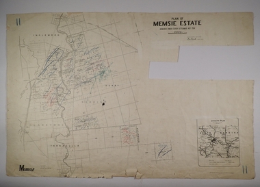
Map - MEMSIE ESTATE, 26/08/1905
... Act 1904. Parish plan. Map dated 26/08/1905..... Parish plan. Map dated 26/08/1905. Map MEMSIE ESTATE ...Map:Plan of Memsie estate, aquired under Closer Settlement Act 1904. Parish plan. Map dated 26/08/1905.map, estate, memsie estate, closer settlement act 1904. -
Bendigo Historical Society Inc.
Map - PART PARISHES OF MARONG AND LOCKWOOD, No date visible
... Map: Section of Parish plan of Bendigo, covering Kangaroo... Bendigo city streets Parish of Marong Parish of Lockwood Kangaroo ...Map: Section of Parish plan of Bendigo, covering Kangaroo Flat, Golden Square, and Specimen Hill ( number 146 in Map Cupboard 1)Map 10map, bendigo, city streets, parish of marong, parish of lockwood, kangaroo flat, golden square, specimen hill -
Bendigo Historical Society Inc.
Map - PARISH OF HUNTLY(PART) AND SANDHURST(PART), No date visible
... Map: Part of parish plan of Bendigo, covering Strathdale... Strathdale White Hills Huntly North bendigo Map: Part of parish plan ...Map: Part of parish plan of Bendigo, covering Strathdale, White Hills, Huntly and North Bendigo ( number 144 in Map Cupboard 1)map, bendigo, city streets, parish of hunlty, parish of sandhurst, strathdale, white hills, huntly, north bendigo -
Bendigo Historical Society Inc.
Map - PORTION OF ELMORE ESTATE, 19/10/1920
... of Bendigo. Parish plan Canvas backed ( number 135 in Map Cupboard 1)... of Elmore Estate, Parish of Egerton, County of Bendigo. Parish plan ...Map: Portion of Elmore Estate, Parish of Egerton, County of Bendigo. Parish plan Canvas backed ( number 135 in Map Cupboard 1)map, bendigo, rural, elmore estate, egerton, county of bendigo -
Bendigo Historical Society Inc.
Map - PORTION OF ELMORE ESTATE, 19/10/1920
... of Bendigo. Parish plan Canvas backed ( number 131 in Map Cupboard... of Elmore Estate, Parish of Minto, County of Bendigo. Parish plan ...Map: Portion of Elmore Estate, Parish of Minto, County of Bendigo. Parish plan Canvas backed ( number 131 in Map Cupboard 1)map, bendigo, rural, elmore estate, minto, county of bendigo -
Bendigo Historical Society Inc.
Map - DINGEE SUBDIVISION, 25/11/1913
... , County of Bendigo, Parish Plan, Canvas Backed ( number 128..., County of Bendigo, Parish Plan, Canvas Backed ( number 128 in Map ...Map: Dingee Subdivision, Parishes of Talambe and Yallook, County of Bendigo, Parish Plan, Canvas Backed ( number 128 in Map Cupboard 1)map, bendigo, rural, dingee subdivision, talambe, yallook, county of bendigo -
Bendigo Historical Society Inc.
Map - COUNTRY LANDS, 4/06/1874
... and Nolan, County of Bendigo. Parish plan (number 298 in map... and Nolan, County of Bendigo. Parish plan (number 298 in map ...Map: Country lands, Parishes of Goornong, Egerton, Elmore and Nolan, County of Bendigo. Parish plan (number 298 in map cupboard 1)map, bendigo, country lands, country lands, goornong, elmore, egerton, nolan -
Bendigo Historical Society Inc.
Map - AVAILABLE ALLOTMENTS, 10/08/1908
... and Egerton, County of Bendigo. Parish plan (coloured) (number 330... and Egerton, County of Bendigo. Parish plan (coloured) (number 330 ...map: Available Allotments, Parishes of Whirrakee, Bagshot and Egerton, County of Bendigo. Parish plan (coloured) (number 330 in map cupboard 1)map, bendigo, allotments, available allotments, whirrakee, bagshot, egerton