Showing 11217 items matching "planning "
-
 Glenelg Shire Council Cultural Collection
Photograph - Photograph - Portland Harbour Development, n.d
Port of Portland Authority ArchivesFront: Black & white Photograph of a plan showing proposed changes to the Fisherman's Breakwater area of the Port of Portlandport of portland archives, port of portland -
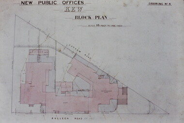 Kew Historical Society Inc
Slide - Architectural Drawing, Kew Public Offices, 1887
A civic campaign for new public offices developed in Kew in the 1880s. After much deliberation, the location chosen was the junction of Bulleen and Cotham Roads. The buildings were designed by George Watson and John Henry Harvey, architects within the Department of Public Works (Victoria). Building was commenced in 1887, and after one year, the buildings were opened. The Post Office was transferred to the new Commonwealth Government in 1901. The Police Station and Court House, sold by the Victorian Government to the City of Boroondara in 2007, are now a community cultural centre and performing arts venue.The buildings were listed on the Victorian Heritage Register Register (HO885) in 1991. They are historically and architecturally significant to the State Of Victoria because Watson and Harvey's designs exhibit diversity in integrating civil offices, they accommodate the apex of road junctions, and they demonstrate a departure from the contemporaneously favoured High Victorian Classical to the Queen Anne style in the design of civic buildings. 35mm colour transparency of an original plan by George Watson and John Henry Harvey, architects of the Department of Public Works (Victoria), in 1887 for New Public Offices at Kew. This plan was copied by the donor from an original held at the Commonwealth Archives in Brighton (Vic). The copy was made to illustrate a report that the donor made on ‘The functional planning design, building materials and construction methods of the Kew Post Office’ as part of course work at RMIT.NEW PUBLIC OFFICES KEW / BLOCK PLAN / SCALE 16 FEET TO ONE INCH / DRAWING NO 4kew court house, kew police station, kew post office, architectural drawings, khs - slides, new public offices — kew (vic.), architecture — queen anne style -
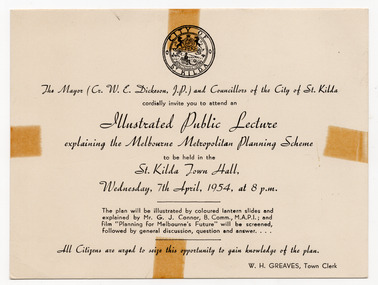 St Kilda Historical Society
Ephemera - Invitation, Illustrated Public Lecture, 1954
... Planning ...Invitation to a lecture on the Melbourne Metropolitan Planning Scheme, presented by the City of St Kilda, at the St Kilda Town Hall at 8pm on 7 April 1954. The lecture was to be illustrated by 'coloured lantern slides' and followed by a screening of the film 'Planning for Melbourne's Future'. The Melbourne Metropolitan Planning Scheme 1954: Report, compiled by the then Melbourne and Metropolitan Board of Work, began the planning system for Melbourne. It planned for a population of 2.5 million in the 1990s, a population actually reached in the 1970s. .White card printed in black on one sidemelbourne metropolitan planning scheme, town planning, planning -
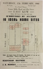 Kew Historical Society Inc
Plan - Subdivision Plan, Subdivision by Auction: 16 Ideal Home Sites, East Kew, 1940, 1940
An advertisement for the sale of a subdivision by Auction: of 16 Ideal Home Sites, East Kew, 1940. This significant sale of land between the Kew Golf Course and Willsmere Park led to the streets having a high degree of architectural uniformity.The subdivision in the second year of the war indicates that land sales for homes and speculation continued from the 1930s into the period of the Second World War. There is no indication on the plan that a war is occurring.Single page subdivision plan advertising the sale by Auction of 16 Ideal Home Sites, in East Kew, on 17 February 1940. Streets named in the plan include: Kilby Road, Belford Road, Elm Grove, Willow Grove. Willsmere Park is indicated but not named. The auction was conducted by Beauchamp Brothers. A number of lots are coloured pink on the plan indicating those lots for sale and/or those already sold.subdivision plans - kew east (vic) -
 Federation University Historical Collection
Plan, Berry Bank Estates
This plan is associated with former Ballarat School of Mines Student Richard Squire (1875-1876). Gift of the Squire FamilyPlan of Berry Bank Estates. Coloured plan on cream paperberry bank estates, mining, happy valley, lake rosine estates, strathvean estates proprietary, w. luplaupitfield plateau, british banner, federal mint, moller, morrow, south pitfield consols, east banner, new lallah rookh, bull dog company, mindai, j. morpoh, poliah, f. j. morrow, piggoreet east, w. m. acheson, grand trunk, field's claim south grand trunk, south grand trunk, woady yalloak creek, mount misery creek, fitzpatric's creek, illabrook creek, great western, mount bute syndicate, narringhill creek, little woady yalloak creek, piggoreet east preemptive right, southern birthday, new birthday, prince of wales, collins, brassey birthday, howarth's lead, w. price, royal birthday, a. clinton, victoria express, patons, williams fancy, hennessy, queen of the south, n, pandora proprietary gold estate, lyonbank lease, rowe's southern, rowe's extended, w. t. rowe, wallinduc company, glenfine horseshoe company, rowe's glenfine junction, wallinduc syndicate, pitfield estates, rowe's estate, southern glenfine, h. fields, christies & fields, balmoral company, glenfine united, hallett, great glenfine, rowe consuls, nicholls, london & melbourne gold mine, j. w. pascoe, christies, glenfine central, j. king, j. durston, great western extended, oswald, woadyyaloak, berringa, squire -
 Greensborough Historical Society
Planning Document, Banyule City Council, Site plan of Greensborough 1997, 28/07/1997
Site plans for the area bounded by Flintoff Street; Grimshaw Street; Main Street and Para Road Greensborough. these plans show the area before the development of Watermarc.This plan shows central Greensborough before the Watermarc developmentSet of 8 site plansgreensborough, greensborough swimming pool -
 Bendigo Historical Society Inc.
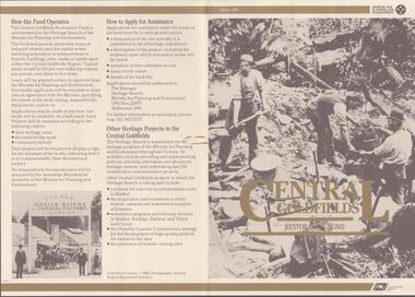
Document - CENTRAL GOLDFIELDS RESTORATION FUND, March 1986
Pamphlet on the Central Goldfields Restoration Fund issued by the Victorian Ministry for Planning and Environment. Includes a map of the central goldfields region, introduction by Jim Kennan (Minister) and 3 photographs. Also a description on how the fund operates and how to apply for assistance. An insert of 2 blank application forms. Photos show , Miners using a sluice at Tarnagulla c.1880. Cnr of Sturt and Lydiard Sts, Ballarat c.1880. E. Eberhard Cordial Factory at Clunes c.1890.Victorian Ministry for Planning and Environmentorganization, government, central goldfields, restoration fund, ministry for planning and environment, j. kennan, tarnagulla, ballarat, clunes. -
 Warrnambool and District Historical Society Inc.
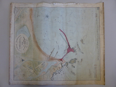
Map, Warrnambool Harbour 1879, 1879
This map shows the plans by eminent harbour engineer, Sir John Coode in 1879. Construction of the breakwater commenced in 1884 and was completed in 1890. Coode first visited Australia in 1872 when he commenced work with the Melbourne Harbour Trust to report on ways to improve Melbourne Port. He is considered one of the most eminent harbour engineers of the 19th century. His original plans for Warrnambool were revised because of cost but then subsequently found to be inadequate and later extended. This was not successful either and the harbour continues to have silting problems to this day. The Warrnambool Breakwater is of historical importance to Victoria and as this map depicts the original plans, it too has great historical significance. It is also significant with its association with Sir John Coode, who was one of the most important port engineers of the 19th century. He worked to improve ports along the Victorian coast including Portland, Geelong, Port Fairy and Lakes Entrance. While this map demonstrates the engineering skills of the era, it also reflects the limitations when natural elements are involved. Its Historical importance also lies in the depiction of items on the map which relate to Warrnambool’s early history. Paper on linen map coloured, and depicting the harbour area of Warrnambool with the proposed breakwater plan in red. It has Victorian Harbours information in oval at top of map. It shows depths of some areas.In oval at top, “Victorian Harbours Warrnambool plan to accompany Sir John Coode report dated 28th Feb 1879. Drawing No 2. Scale 500 feet to 1 inch at bottom centre. Sir John Coode signature in bottom left corner. A 33 A on bottom left reversesir john goode, warrnambool harbour map, warrnambool harbour map 1879, port of warrnambool map 1879 -
![Map, [Plan for road to give J. Allan access to permanent water at Coimadai] circa 1870s](/media/collectors/5e461d8021ea67224c82f2a1/items/67735190d671e67dd573a84c/item-media/6773533dd671e67dd573cd90/item-fit-380x285.jpg) Bacchus Marsh & District Historical Society
Bacchus Marsh & District Historical SocietyMap, [Plan for road to give J. Allan access to permanent water at Coimadai] circa 1870s
The date of this map or plan is uncertain but it appears to be from the early to mid 1870s. One of the landholders identified on the plan, James Allan of Coimadai died suddenly on the 9th July, 1874 (see Bacchus Marsh Express, 11 July, 1874, page. 3). There are mentions of an Allans Road at Coimadai in the Bacchus Marsh Express between 1887 and 1942.Single page map showing an excision of land belonging to Charles Ross which was selected to construct a road to give another landholder, J. Allan access to permanent water. Scale 1 chain to 1 inch. Part of a set of maps which are pasted into a bound volume containing 76 maps or plans in total. High resolution digital image stored on BMDHS computer network. Plan showing Excisions from Ross's selection and 1 chain road thro' the said selection in Coimadai to give J. Allan access to permanent water. Alistair ?? Shire Eng? 6?/5/7?coimadai victoria maps, coimadai roads and streets -
Whitehorse Historical Society Inc.
Map, Blackburn East Primary School
Plans of Blackburn East Primary SchoolPlans of Blackburn East Primary School (1)1957; (2) Master Plan ; (3) Master Plan 1973. (4) Scheme F: Staff and administrative facilities 1974, Scale 1/8:1'Plans of Blackburn East Primary Schoolblackburn east primary school no. 4800, master plan, admin facilities -
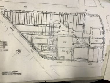
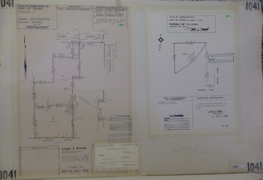 Greensborough Historical Society
Planning Document, Subdivision Plan #1041. Elder Street Greensborough, 20/04/1983
Plan of Consolidation of Allotments 3 and 4 Brixton Avenue and Plan of Subdivision for Elder Street. An example of hard copy subdivision plans from the Greensborough area. Mainly from the Shire of Diamond Valley era (1964-1994).Plan (2 sheets) mounted on heavy card.Stamped and handwritten Council permissions, dates and other details.subdivision plans, elder street, brixton avenue -
 Glenelg Shire Council Cultural Collection
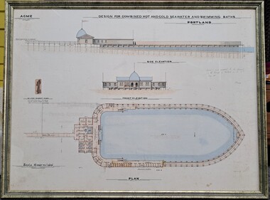
Drawing, ACME, Design for Combined Hot and Cold Seawater and Swimming Baths - Portland, c. 1888
Drawing/plan showing the design for the Portland Seabaths. At the top of the plans is the side elevation titled underneath, below is the front elevation and at the bottom the whole plan from the top. The scale is 16 feet to 1 inch. There is also an image of the Wilson Donkey Pump.Top Left - ACME Design for Combined Hot and Cold Seawater and Swimming Baths / Portland In handwriting to the right of the plan ' Agreed to and adopted by the Council of the Borough of Portland on the 30th May 1888'portland sea baths, seawater baths, acme, design, plan -
 Bendigo Historical Society Inc.
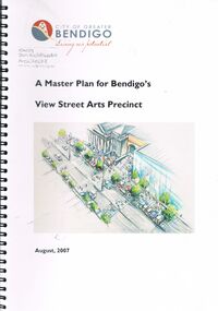
Book - CITY OF GREATER BENDIGO: MASTER PLAN FOR BENDIGO'S VIEW STREET ARTS PRECINCT AUGUST 2007, August 2007
... Planning ...City of Greater Bendigo Document ''A Master Plan for Bendigo's View Street Arts Precinct. August 2007. Don Goldsworthy - Architect and Urban Designer, Positive Solutions Arts Facilities and Business Planning, Cardno Grogan Richards Engineering and Traffic Management. Booklet 47 Pages.City of Greater Bendigobendigo, planning, view street arts precinct, http://www.bendigotourism.com/things-to-do/bendigo-arts-culture/view-street-arts-precinct -
Port Melbourne Historical & Preservation Society
Plan - Street levels, c. 1862
Drawn up to replace rescinded portions of street plan of March 1862.Plan of street levelsDetails and signatures as belowengineering - roads streets lanes and footpaths, frederick william bull, thomas swallow, edward clark, town clerks -
 Kew Historical Society Inc
Slide - Architectural Drawing, Kew Public Offices, 1887
A civic campaign for new public offices developed in Kew in the 1880s. After much deliberation, the location chosen was the junction of Bulleen and Cotham Roads. The buildings were designed by George Watson and John Henry Harvey, architects within the Department of Public Works (Victoria). Building was commenced in 1887, and after one year, the buildings were opened. The Post Office was transferred to the new Commonwealth Government in 1901. The Police Station and Court House, sold by the Victorian Government to the City of Boroondara in 2007, are now a community cultural centre and performing arts venue.The buildings were listed on the Victorian Heritage Register Register (HO885) in 1991. They are historically and architecturally significant to the State Of Victoria because Watson and Harvey's designs exhibit diversity in integrating civil offices, they accommodate the apex of road junctions, and they demonstrate a departure from the contemporaneously favoured High Victorian Classical to the Queen Anne style in the design of civic buildings. 35mm colour transparency of an original plan by George Watson and John Henry Harvey, architects of the Department of Public Works (Victoria), in 1887 for New Public Offices at Kew. This plan was copied by the donor from an original held at the Commonwealth Archives in Brighton (Vic). The copy was made to illustrate a report that the donor made on ‘The functional planning design, building materials and construction methods of the Kew Post Office’ as part of course work at RMIT.NEW PUBLIC OFFICES KEW/ FIRST FLOOR & ROOF PLAN / DRAWING NO 1 / SCALE 8 FEET TO ONE INCHkew court house, kew police station, kew post office, architectural drawings, khs - slides, new public offices -- kew (vic.), architecture — queen anne style -
 Greensborough Historical Society
Planning document, City of Heidelberg, Subdivision Plan # G26. Grace Park Estate Greensborough, 1950c
Plan of Subdivision (G26). Grace Park Estate. An example of hard copy subdivision plans from the Greensborough area. From Shire of Heidelberg.Plan mounted on heavy card.Stamped and handwritten Council permissions, dates and other details.subdivision plans, grace park -
 Federation University Historical Collection
Plan, Burrumbeep, 1884, 16/10/1884
Auctions of Crown land were introduced in the Colony of Victoria from 1851 to encourage settlers to occupy and work the land. Many squatters purchased land at auction at the upset (minimum) price of £1 per acre. In some areas where demand was high, such as the goldfields, the price realised at auction was much more. Land was put up for sale in the study area on the Burrumbeep run in May 1855, on the Lexington run in 1857, and on the Gorrinn run in 1858. (http://www.ararat.vic.gov.au/library/document/thermatics.pdf, accessed 27 January 2015) For 70 years or more, Yalla-y-Poora, Burrumbeep, Edgarley, Mount William and Narrapumelap ranked in the leading wool producers in Victoria. 1 Stud owners at Yalla-y-Poora, Eurambeen, Burrumbeep and Challicum crossed merino sheep with sheep descended from John Macarthur's Camden Park in New South Wales. (http://www.ararat.vic.gov.au/library/document/thermatics.pdf, accessed 27 January 2015) In what was to become the Ararat Mining Division, gold was discovered in May 1854 on the Burrumbeep run at a place that became known as Pinky Point on the Mount William goldfield. By 21 June 1854, between 600 and 1,000 people had arrived. (http://www.ararat.vic.gov.au/library/document/thermatics.pdf, accessed 27 January 2015)\ Town allotment plan for Burrumbeep. Merrymbuela, Borung, Lexington and Langi Logan are neighbouring areas. The plan includes the Burrumbeep Pre-Emptive Right (Roger and Wright); licensed land holders including Stephen Young, John Carroll, William Walsh, Thomas Purcell, Martha M. Bond, Colin Johnson, John Charles Webb, Henry Withycombe, William Henry Barbridge, John Wall, Thomas Flatelly, William Jenkinson, Elisia Radford, V. Radford, Denis Byrne, George Cook. Land holders included Andrew Maloney, Richard Wingfield Harrocks, W. Sporton, Terence Lynch, F. S. Falkiner, A. Millman, H. Morris, George Upham, J. McCLure, S. Fletcher, W. Parker, Thomas Myers, William wright, W.C. Winter, C. Wordman, Oliver A. Winter This plan is associated with former Ballarat School of Mines student Richard Squire (1875-6) Gift of the Squire FamilyVerso written in pencil - Plan of Burrembeep Ararat Burrembeep Araratburrumbeep, corrinn, langi logan, merrymbuela, lexington, ararat, roger & wright, cook, rogers, upham, george upham, ross, parsans, morris, johnson, withycoombe, colin johnson, falkiner, dsporton, john carroll, donald gordon, denis bryne, maurice dooley, martha bond, william harricks, \william wingfield harricks, william l.c. harricks, michael houlihan, thomas purcell, martin ryan, michael cody, fletcher, mccaw, w. parker, j.m. clow, elisia radford, thomas radford, thomas myers, barbridge, e. wilde, j. wall, flatelly, g. wardman, w.c. winter, david ball, jenkinson, ballarat school of mines, richard squire, squire -
 Ringwood and District Historical Society
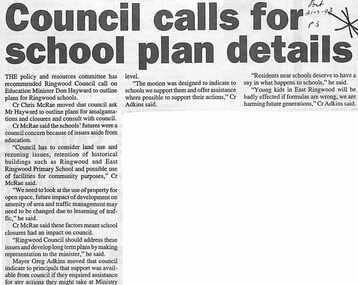
Newspaper, Scrapbook Clipping, Library Collection, Ringwood, Victoria, `
``Newspaper clipping from "The Post", 21-7-93, P 3. NEWS Watch - Council calls for school plan details The policy and resources committee has recommended Ringwood Council call on Education Minister Don Hayward to outline plans for Ringwood schools. Councillor Chris McRae moved that council ask Mr Hayward to outline plans for amalgamations and closures and consult with council.` -
University of Melbourne, Burnley Campus Archives
Book - Report, E.B. Littlejohn, Victoria 1944 State Regional Boundaries Committee Report on Regional Boundaries, 1944
... planning ...See paper catalogue for complete contents. Item formerly property of E.B. LittlejohnReport includes maps of Regions for Planning and Development, geographical, weather, power, water resources, crops, livestock, etc.e.b. littlejohn, planning, development, regions -
Port Melbourne Historical & Preservation Society
Plan - CD-ROM, "State Bank of Victoria - Proposed dwelling Fishermans Bend"
Plans were brought to us by CBA employee Steve Tserkezidis CD with items below. From series of State Bankhouse plans and elevations of types 1 - 8. A1 copies (.01) 1937 (stamp). (.02) 1928. (.03) 1937. (.04) 1937. (.05) no date. (.06) 1928. (.07) 1937. (.08) 1938. From plans accompanying bank House plans .01 to .08; (.09) MMBW plan showing bank properties (.10) Bank house plan: sections through walls. (.11) "Fishermans bend group" plan of properties (.12) Bank House plan of Pier Foundationgarden city, built environment - domestic, state savings bank of victoria, bank houses -
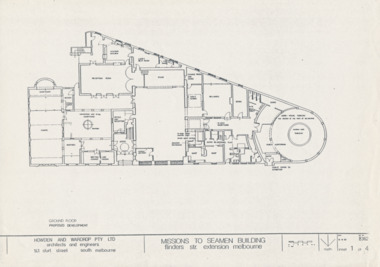 Mission to Seafarers Victoria
Drawing - Architectural drawings, Howden & Wardrop Pty Ltd, Mission to Seamen Building, 1983
3 of the 4 plans by Howden and Wardrop Pty Ltd part of their 1983 report for renovations. They were made from the T. Howes and P. Demetrios plans which were their submission for the Mathew Flinders Measured Drawing Competition as mentioned in the report.A4 copies of original planshowden and wardrop pty ltd, 1983, vhr 1496, t. howes, p.demetrios -
![Plan, Surveyor's Street Plan of Melbourne 1837 [copy], 1837_](/media/collectors/4f729f5697f83e03086015b8/items/534ccbc12162ef06c8d2cbf7/item-media/58afbfe2d0ce1616fcdf244b/item-fit-380x285.jpg) Greensborough Historical Society
Greensborough Historical SocietyPlan, Surveyor's Street Plan of Melbourne 1837 [copy], 1837_
Copy of Surveyor's Street Plan of Melbourne 1837. Donated by Patsy Coverdale and accompanied by brief details of her family connection to the map. Copies of plan available for sale from Greensborough Historical Society.Map of early Melbourne with connections to a current resident.Copy of plan, mounted on timber and framed.melbourne street plan, coverdaye, umpleby -
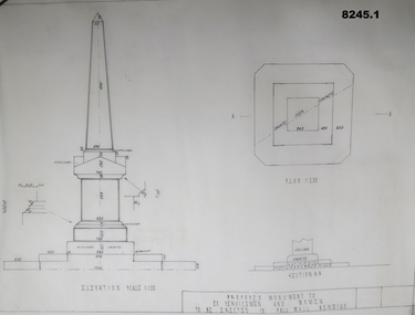 Bendigo Military Museum
Plan - MONUMENT PLANS, C.1992
These plans were for a proposed Memorial to Ex Servicemen and Women to be erected in front of the Soldiers Memorial Institute in Pall Mall Bendigo. This building is now known as "The Bendigo Military Museum".1) .2) Two Cronaflex .004 thick black ink plans , scale 1 - 100showing front elevation and plan of a proposed Monument. Both plans are slightly different showing plan sections."Proposed Monument to Ex Servicemen and Women to be erected in Pall Mall Bendigo"brsl, smirsl, monument, plan, -
 Ringwood and District Historical Society
Photograph, Plan of Lots in Bel-Air Estate 1991
4 photographs of sections of the plans.a. Written on back of photograph, "20/6/81. Plan of Bel Air Estate. Werac Drive runs down left side of plan. Kubis Drive crosses top. Debbie Place drops down from Kubis. Manuela Tce. runs right from Werac, ends at a bend and becomes Rudolf Court running North. Lyn Court takes off right from Rudolf and Burlock Ave. touches estate with an elbow" b. Written on back of photograph, "20/6/81. Plan of lots in Bel Air Estate. Glenvale Road down left side of plan, Kubis Dr. Runs across picture. June Square drops from and Jenken Close rises form Kubis Dr. Werac Dr. drops to bottom of picture and Manuella takes off to right". d. Written on back of photograph, "20/6/91. Lots in Bel-Air Estate. Kubis Dr. rises from bottom left to Oban Road top. Pamela Crt. drops from Kubis at left, Iluka Crt. takes off right. Whitlam Dr. runs left at top and Menzies Cr. drops off it to centre of picture". c. Written on back of photograph, "20/6/81. Plan of lots on Bel-Air Estate. Kubis Dr., Debbie Place, Pamela Crt, Iluka Crt. Menzies Drive" -
Greensborough Historical Society
Document - Digital Image, Marilyn Smith, Greensborough Secondary College Gr8750 Refurbishment Plans 2016, 2016_03
This document shows the plan and finance for a refurbishment of Greensborough College 2016-2017.Digital copy of planning documentgreensborough college -
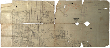 Federation University Historical Collection
Plan, Creswick, County of Talbot
This plan is associated with former Ballarat School of Mines Student Richard Squire (1875-1876). Gift of the Squire Family, 2014 Plan showing allotments in Creswick, County of Talbot. The plan is in a number of pieces with some sections missing.creswick, creswick creek, spring hill, sarah paterson, lehman, mullins, spittle, squire, richard squire -
 Bacchus Marsh & District Historical Society
Map, Plan of the property of Messers Atkins and Clarke to be sold at the Mansion, Bacchus Marsh 19th April 1856. Copy 1
This plan of land allotments for sale indicates the property once owned by the Bacchus family in and around the township area of Bacchus Marsh. The Bacchus family sold their property in Bacchus Marsh to John Atkins and Robert Nalder Clarke in March 1851. Atkins and Clarke kept the property for a number of years until April 1856 when these allotments were put up for sale.This plan is almost identical to another copy held by the Bacchus Marsh and District Historical Society, VC Record 452, BMDHS collection). This plan, VC Record 707 Copy 1, contains a little more detail overall than VC Record 452 Copy 2, such as who did the survey work for the plan (R.C. Bagot) and who the selling agents were, (W.M. Tennent), and on the right side of the plan near the Lerderderg River is indicated the general area for a second parcel of land from this sale which is to be sold. There is also a compass illustration indicating north and south compass points.This is a very early land sales plan for the township of Bacchus Marsh and it therefore provides some clues as to how the early urban development of the township took place. Upon seeing the map in 1911 Bacchus Marsh Express newspaper editor Christopher Crisp wrote "The sale appears to have created the present township, which had a nucleus in earlier times further east", Express, 30 September, 1911, page 3.A single page paper plan showing allotments of land for sale. The subdivided land shown was owned by John Atkins and Robert Nalder Clarke, but previously owned by the Bacchus Family and was in and around their Manor House (Mansion) property in Bacchus Marsh.There are 5 portions of land further divided into numerous small portions. The land for sale is bounded by the present day streets of Main Street, Young Street, McFarland Street, Morton Streets, Crook Street, and part of the eastern section extends to the Lerderderg River. Scale: 8 chains to 1 inch The plan is pasted into a bound volume containing 76 maps or plans in total. BMDHS Loc: AR/B12/S4 Bacchus Marsh Township and Nearby Districts Maps Volume In-house Digital copies: BMDHS, Computer Network: Maps\Bacchus Marsh Township and Nearby Districts Maps VolumeHeading: Plan of the first portion of land. The property of Messers Atkins and Clarke situate at Bacchus Marsh. To be sold by W.M. Tennent & Co. at the Mansion on the Ground on Saturday the 19th April 1856. Below heading: Jas Ferguson, Lithographer On upper right side: Subdivided by R.C. Bagot London and Liverpool Chambers, Melbourne. 'Thos Taubman'. Post Office Stamp: BACCHUS MARSH VICTORIA MY 6, 63bacchus marsh victoria maps, bacchus family, land sales, manor house bacchus marsh -
 Ringwood and District Historical Society
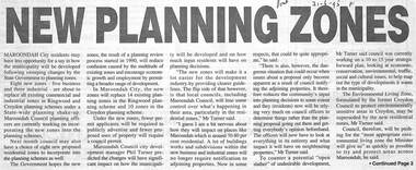
Newspaper, Scrapbook Clipping, Library Collection, Ringwood, Victoria
Newspaper Clipping from "The Post", 21/6/1995. P1. New Planning ZonesMaroondah City residents may have less opportunity for a say in how the municipality will be developed following sweeping changes by the State Government to planning zones -
 Wodonga & District Historical Society Inc
Album - Hume Reservoir Australia Album - Plans and Progress Photos - River Murray Water Scheme, Department of Public Works, N.S.W, 1927
This set of photos is from a leather bound album bearing the inscription "HUME RESERVOIR AUSTRALIA" plus 'The Rt. Hon. L. C. M. S. Amery, P. C., M .P.' all inscribed in gold. It was presented to The Rt. Hon. L. C. M. S. Amery, P. C., M. P, Secretary of State for Dominion Affairs on the occasion of his visit to the Hume Reservoir on 2nd November 1927. This album is of local and national significance as it documents the planning and development of the Hume Reservoir up to 1927. It was the largest water reservoir in the British Empire. The album records the pioneering engineering work that went into its construction.1. Locality Plan and Plan of Dam. The dam is about ten miles by road upstream from Albury and about three-quarters of a mile below the confluence of the Mitta Mitta River and the Murray River. Its main features consist of a concrete portion across the bed of the river with earth embankment at both ends. The foundations throughout are on hard granite, found at an average depth of about 40 feet below the surface, the centre line being located to take advantage of the most favourable rock levels.Heading on page "WORKS UNDER RIVER MURRAY WATERS AGREEMENT/HUME RESERVOIR" Beneath top diagram "FIG. 1. ELEVATION" Beneath second diagram "FIG. 2. PLAN" On map "LOCALITY PLAN"hume reservoir australia, river murray waters scheme, hume weir diagrams, hume weir location -
 National Wool Museum
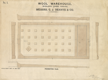
Plan - Architectural Plan, Wool Warehouse, Moorabool St, Geelong for Messrs C.J. Dennys & Co., Foundation Plan No. 1
Original Jacob Pitman architectural plan of the Dennys Lascelles bluestone woolstore dated 1 March 1871. Titled "Wool Warehouse, Moorabool St, Geelong for Messrs C.J. Dennys & Co., Foundation Plan No. 1".Wool Warehouse, Moorabool St, Geelong for Messrs C.J. Dennys & Co., Foundation Plan No. 1wool stores, pitman, mr jacob, dennys lascelles wool store