Showing 25583 items matching "plenty-township-estate"
-
 Stawell Historical Society Inc
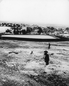
Photograph, Town Reservoir with Mr John D'alton & viewing of the township in the background
Reservoir on Big Hill (Early Scene)B/W Two males; closest has full beard in front of town reservior on Big Hill, background view of townshipstawell -
 Ringwood and District Historical Society
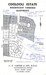
Document - Folder, Coolooli Estate Subdivision, Ringwood East, Vic. - Four Releases 1969-1975
Collection of Subdivision Plans, Land Sale flyers, Auction notices, and Real Estate Agent's notes for Coolooli Estate, Ringwood East, Victoria. Subdivision includes Coolooli Court, Isabel Avenue, Walhalla Drive, Cleland Street, Landell Court, Byways Drive, Heathwood Street and Hume Street, released over four stages - First Stage auction 16 August 1969, Second Release private sales from July 1970, Third Release Auction 11 September 1971, Final Release auction June 21st 1975. Agents - C.E. Carter & Son, 126 Whitehorse Road, Ringwood until moving to 122 Whitehorse Road in 1973 - Tel. 870 6024, 870 6830, 870 2519, A.H. 723 3298, 870 6960. Digitised copy of photograph - A.B. Carter and Andy McLean at Coolooli Estate auction, 11 September, 1971. -
 Whitehorse Historical Society Inc.
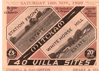
Pamphlet, Auction - Station Front Estate & Whitehorse Hill Estate
Sale of Station Front Estate and Whitehorse Hill estateSale of Station Front Estate and Whitehorse Hill estate 16/11/1929. 4o villa sites - 20/- per lot, per month, L3 depositSale of Station Front Estate and Whitehorse Hill estate station front estate, whitehorse hill estate, walker, edgar edwardes, coghill & haughton, drake & co., calcutta street, mitcham, simla street, benares street, delhi street, mitcham road, esplanade, barkly terrace, madden & candy, solicitors -
 Whitehorse Historical Society Inc.
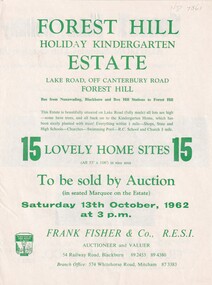
Document, Forest Hill Estate, 13/10/1962 12:00:00 AM
Fifteen home sites to be auctioned by Frank Fisher & Co. on 13 Oct 1962.Fifteen home sites to be auctioned by Frank Fisher & Co. on 13 Oct 1962 called Forest Hill Estate in Lake Road, Forest Hill.Fifteen home sites to be auctioned by Frank Fisher & Co. on 13 Oct 1962.forest hill estate, lake road, forest hill, frank fisher co. -
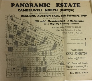 Kew Historical Society Inc
Plan - Subdivision Plan, Panoramic Estate, Camberwell North (Balwyn), 1939, 1939
Subdivision plan advertised as the Panoramic Estate, Balwyn, showing lots for sale in the following streets: Bulleen Road, Macedon Avenue, The Moor, Sunburst Avenue, Doncaster Road, Fortuna Avenue, Longview Road, The Nook, and Touring Avenue.Single page subdivision plan of the Panoramic Estate in Camberwell North (Balwyn); offered for sale in 1939Nilsubdivision plans - balwyn (vic), panoramic estate - camberwell north - balwyn (vic) -
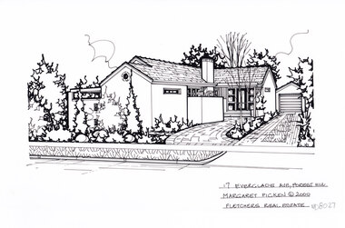 Whitehorse Historical Society Inc.
Artwork, other - Ink Line Drawing, Margaret Picken, 17 Everglade Ave., Forest Hill, 2000
A property illustration by Margaret Picken Commissioned by the real estate agency Woodards Blackburn for the purpose of advertising 17 Everglade Ave., Forest Hill Made by using Rotring ‘Rapidigraph’ drafting pens with Rotring ink on Rapidigraph polyester drafting film, double matte. Trained as a cartographic draftsman within the mining industry, Margaret Picken is an artist who worked producing property illustrations for real estate agencies in eastern suburbs of Victoria from 1983-2005. Retiring from the industry as technological changes favored coloured photography over illustrations, and commissioning companies over sole contractors.This artwork is of Historical Significance as a record of local domestic architecture.A black ink line drawing on drafters film by Margaret Picken, of 17 Everglade Ave., Forest Hill. depicting a rendered L shape house with a path and driveway on the left.17 Everglade Ave., Forest Hill Margaret Picken © 2000 Fletchers Real Estatewhitehorse historical society, schwerkolt cottage, housing, architecture, margaret picken, house, garden, forest hill -
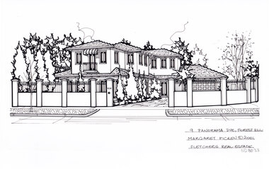 Whitehorse Historical Society Inc.
Artwork, other - Ink Line Drawing, Margaret Picken, 9 Panorama Dve., Forest Hill, 2001
A property illustration by Margaret Picken Commissioned by the real estate agency Fletchers for the purpose of advertising 9 Panorama Dve., Forest Hill. This property is listed as having sold for $525,000 in 2001. Made by using Rotring ‘Rapidigraph’ drafting pens with Rotring ink on Rapidigraph polyester drafting film, double matte. Trained as a cartographic draftsman within the mining industry, Margaret Picken is an artist who worked producing property illustrations for real estate agencies in eastern suburbs of Victoria from 1983-2005. Retiring from the industry as technological changes favored coloured photography over illustrations, and commissioning companies over sole contractors.This artwork is of Historical Significance as a record of local domestic architecture.A black ink line drawing on drafters film by Margaret Picken, of 9 Panorama Dve., Forest Hill, of a two story rendered house set back from a high wrought iron and render fence, with driveway on the right leading to a connected garage.9 Panorama Dve., Forest Hill Margaret Picken © 2001 Fletchers Real Estatewhitehorse historical society, schwerkolt cottage, housing, architecture, margaret picken, house, garden, forest hill -
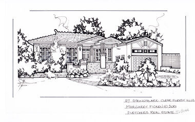 Whitehorse Historical Society Inc.
Artwork, other - Ink Line Drawing, Margaret Picken, 27 Stringybark Close., Forest Hill, 2001
A property illustration by Margaret Picken Commissioned by a real estate agency for the purpose of advertising 27 Stringybark Close., Forest Hill. This property is listed as having sold for $430,000 in 2002. Made by using Rotring ‘Rapidigraph’ drafting pens with Rotring ink on Rapidigraph polyester drafting film, double matte. Trained as a cartographic draftsman within the mining industry, Margaret Picken is an artist who worked producing property illustrations for real estate agencies in eastern suburbs of Victoria from 1983-2005. Retiring from the industry as technological changes favored coloured photography over illustrations, and commissioning companies over sole contractors.This artwork is of Historical Significance as a record of local domestic architecture.A black ink line drawing on drafters film by Margaret Picken, of a single story brick house, with sweeping steps up to the porch and front door. set back from a horseshoe shaped driveway, and greenery. There are two hole punch holes near the centre of the upper edge.27 Stringybark Close., Forest Hill Margaret Picken © 2001 Fletchers Real Estatewhitehorse historical society, schwerkolt cottage, housing, architecture, margaret picken, house, garden, forest hill, real estate -
 Whitehorse Historical Society Inc.
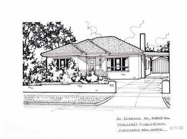
Artwork, other - Ink Line Drawing, Margaret Picken, 20 Husband Rd., Forest Hill, 2000
A property illustration by Margaret Picken Commissioned by the real estate agency Woodards Blackburn for the purpose of advertising 20 Husband Rd., Forest Hill This property is listed as having sold for $199,500 in 2001. Made by using Rotring ‘Rapidigraph’ drafting pens with Rotring ink on Rapidigraph polyester drafting film, double matte. Trained as a cartographic draftsman within the mining industry, Margaret Picken is an artist who worked producing property illustrations for real estate agencies in eastern suburbs of Victoria from 1983-2005. Retiring from the industry as technological changes favored coloured photography over illustrations, and commissioning companies over sole contractors.This artwork is of Historical Significance as a record of local domestic architecture.A black ink line drawing on drafters film by Margaret Picken, of 20 Husband Rd., Forest Hill, depicting a single story brick house, with driveway leading to a connected carport on the left. In the foreground, a low brick fence and front lawn.20 Husband Rd., Forest Hill Margaret Picken © 2000 Fletchers Real Estatewhitehorse historical society, schwerkolt cottage, housing, architecture, margaret picken, house, garden, forest hill -
 Pyrenees Shire Council
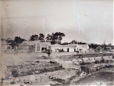
photograph, Untitled (Main thoroughfare through the township of Lexton ), c1880s
significant to the Pyrenees Shire and Lexton communityphotograph of Lexton streetscape "Throughfare through the township of Lexton in approx. 1880-1885 showing the Lexton Shop, Lexton Hotel and St. Mary's Anglican Church" -
 Kew Historical Society Inc
Plan - Subdivision Plan, Eastlawn Estate, 1914
Subdivision plans are historically important documents used as evidence of the growth of suburbs in Australia. They frequently provide information about when the land was sold on which a built structure was subsequently constructed as well as evidence relating to surveyors and real estate and financial agents. The numerous subdivision plans in the Kew Historical Society's collection represent working documents, ranging from the initial sketches made in planning a subdivision to printed plans on which auctioneers or agents listed the prices for which individual lots were sold. In a number of cases, the reverse of a subdivision plan in the collection includes a photograph of a house that was also for sale by the agent. These photographs provide significant heritage information relating house design and decoration, fencing and household gardens.The ‘Eastlawn Estate’ was surveyed and ready for auction in March 1914, three months before the outbreak of World War I. Sixty-six allotments, created on the ‘order of Mr & Miss Preston’ surrounded the mansion of Woodlands in Harp Road. Woodlands formed part of the Estate, being advertised as lot 1. The allotments faced High, Station and Wright Streets, Harp and Normanby Roads, and Woodlands Avenue. Pru Sanderson in the Kew Conservation Study (Vol.2, 1988) wrote that the Eastlawn Estate ‘covered the western half of the failed Harp of Erin Estate’. Contemporary advertisements promoted the Eastlawn Estate as: ‘There will be no more convenient district nor pleasant Suburb than East Kew for the busy business man. When the Electric Tram is laid, he will be able to journey quickly and pleasantly direct from Collins Street to his home in the Eastlawn Estate in about 20 minutes’. The actual plans of subdivision were included in advertisements in The Argus and in the local newspapers.subdivision plans - east kew, eastlawn estate -
 City of Kingston
Pamphlet - Colour, Arthur Tuckett & Son, Auctioneers and Subdivisional Specialists, Auction of Station Estate, Moorabbin, 1923
Sales plan for land in the suburb of Moorabbin, bounded by Railway Crescent, South Road, Jasper Road and Pattersons Road.The developing urban area of Moorabbin within the City of Kingston. This land sale pamphlet illustrates the subdivision of land within the municipality and the changing demographic of the district as new houses are constructed.Colour pamphlet advertising an auction of the Station Estate Moorabbin. Incorporates details of the shopping facilities, proximity to the railway line, variety of schools and churches in the area, and a sales plan for home sites and shop fronts. Incorporates a map of the estate bordered by Pattersons Road, Japer Road, South Road and Railway Crescent. Handwritten in grey pencil top right front page: Station Estate / late [indecipherable] Handwritten in red pencil on subdivision map: x [on majority of properties marked on the map] Handwritten in grey pencil on subdivision map: additional subdivisions drawn in and large lines drawn across the mapmoorabbin, land sales, estate -
 Ringwood and District Historical Society
Document - Land Sale Folder, Auburn Grove Estate Ringwood East - 2011-2013
Folder containing flyers and multi-fold colour pamphlet advertising Auburn Grove Estate with maps and layout of subdivision and photographs of area. Flyers for First Release Auction 6 August, 2011 enclosed, and Second and Final Release Private Sale flyer with copy showing handwritten sale prices.Estate plan includes Auburn Grove off Longview Road and adjoining Tintern Grammar School, Ringwood East, Vic. Agents - Carter Real Estate, 90 Maroondah Highway, Ringwood Vic 3134. Phone 9870 6211 Fax 9870 6024. Accompanying folder includes handwritten auctioneer's notation (Richard Carter) on the name, that Auburn Grove Estate is adjacent to Tintern Farm - Tintern School originally having moved to Ringwood East from Auburn, Melbourne (1953). -
 Kew Historical Society Inc
Plan - Subdivision Plan, Forres Estate, East Kew, 1919, 1919
Pru Sanderson, in her groundbreaking ‘City of Kew Urban Conservation Study : Volume 2 - Development History’ (1988), summarised the periods of urban development and subdivisions of land in Kew. The periods that she identified included 1845-1880, 1880-1893, 1893-1921, 1921-1933, 1933-1943, and Post-War Development. These periods were selected as they represented periods of rapid growth or decline in urban development. An obvious starting point for Sanderson’s groupings involved population growth and the associated economic cycles. These cycles also highlighted urban expansion onto land that was predominantly rural, although in other cases it represented the decline and breakup of large estates. A number of the plans in the Kew Historical Society’s collection can also be found in other collections, such as those of the State Library of Victoria and the Boroondara Library Service. A number are however unique to the collection.Subdivision plans are historically important documents used as evidence of the growth of suburbs in Australia. They frequently provide information about when the land was sold on which a built structure was subsequently constructed as well as evidence relating to surveyors and real estate and financial agents. The numerous subdivision plans in the Kew Historical Society's collection represent working documents, ranging from the initial sketches made in planning a subdivision to printed plans on which auctioneers or agents listed the prices for which individual lots were sold. In a number of cases, the reverse of a subdivision plan in the collection includes a photograph of a house that was also for sale by the agent. These photographs provide significant heritage information relating house design and decoration, fencing and household gardens.An annotated subdivision plan for the Forres Estate, Kew East. The estate was advertised in 1919, the Melbourne Auctioneers being represented locally by Henry Kellett, Estate Agent of High Street, Kew. The name of the estate was derived from the mansion (demolished 2016) of the same name in Normanby Road, which was at one stage owned by the Mayor of Kew, Cr. J. S. Were.subdivision plans - kew, forres estate, argyle road, simpson street, hubert street, normanby road -
 Ringwood and District Historical Society
Brochure, Farros Falcon Press, Heathmont Station Estate Pamphlet incl sub division plan (undated0, Not Known
Promotional brochure from estate agents H. C. Costello & Co Auctioneers for the Heathmont Station Estate: 140 beautiful home sites.Large buff coloured bifold pamphlet advertising Heathmont Station Estate. Red and black printing; photo on front and back; subdivision plan inside. +Additional Keywords: Costello, H. C. & Co. -
 Ringwood and District Historical Society
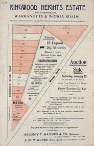
Flyer, Land Auction Sale Advertisement - Ringwood Heights Estate, Ringwood, Victoria - circa 1923
Advertisement for land and weatherboard villa auction sale on Saturday, January 13 (1923?) - Ringwood Heights Estate, corner Warrandyte and Wonga Roads, North Ringwood, with terms of sale, summary of local features and services, and map showing layout of subdivisionSubdivision includes Wonga Road and Anderson's Creek Road (later Warrandyte Road). Agents - Sydney T. Haynes & Co., Auctioneers, 60 Queen Street, Melbourne. Phone Central 3400; J.B. McAlpin, Estate Agent, Opposite Ringwood Station. Auction in the Trust Estate of J.J. Parker, instructed by the Equity Trustees Co. Ltd. 85 Queen Street, Melbourne. -
 Greensborough Historical Society
Photograph - Photograph (Copy), Anne Paul, Plenty River in flood 2003, Lower Plenty, 2003_12
Two views of Plenty River in flood, Lower Plenty.2 colour photographs printed on paper, handwritten captionslower plenty, plenty river, floods -
 Greensborough Historical Society
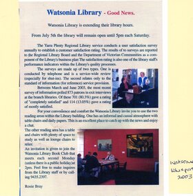
Article - Newspaper Clipping and Flyer, Watsonia Traders Association, Watsonia Library: Good News: Watsonia Library is extending their library hours, 05/07/2003
Watsonia Library extends Saturday opening hours in July 2003. Newspaper clipping from Watsonia's Whisper and flyer from Yarra Plenty Regional Library (YPRL) inviting patrons to the opening celebrations.News article. Black, red and blue text and colour image on colour background. yarra plenty regional library, yprl, watsonia library -
 Eltham District Historical Society Inc
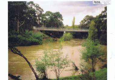
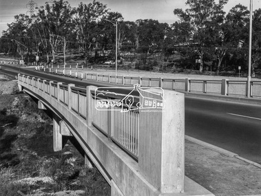
Photograph, Shire of Eltham, New bridge over the Plenty River, Lower Plenty, Nov. 1966
Newly constructed single span bridge on Main Road (now Lower Plenty Road) crossing the Plenty River at Lower Plenty. Site of Heidelberg Golf Club and Lower Plenty Hotel in the background. This was the boundary between the Shire of Eltham and the City of Heidelberg.This photo forms part of a collection of photographs gathered by the Shire of Eltham for their centenary project book ,"Pioneers and Painters: 100 years of the Shire of Eltham" by Alan Marshall (1971). The collection of over 500 images is held in partnership between Eltham District Historical Society and Yarra Plenty Regional Library (Eltham Library) and is now formally known as 'The Shire of Eltham Pioneers Photograph Collection.' It is significant in being the first community sourced collection representing the places and people of the Shire's first one hundred years.Digital imagesepp, shire of eltham pioneers photograph collection, lower plenty, bridge -
 Ringwood and District Historical Society
Photograph, Images used for land sale promotion of Coleman's Heathmont Estate, looking across the estate from Canterbury Road, Heathmont towards Bedford Road on the far boundary. Sale 15/12/1923 by Public Auction
Catalogue card reads, "Coleman's Heathmont Estate 1923. 15/12/1923. Looking across the estate from Canterbury Rd. Bedford Rd. is seen on the far boundary." -
 Victorian Aboriginal Corporation for Languages
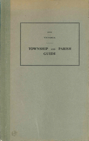
Book, Department of Crown Lands and Survey Victoria, Township and parish guide : Victoria, 1955
A alphabetical list of townships proclaimed under the Land Acts of Victoria. Shows the parish, land district and the municipality in which each is situated, and the particulars of Gazettal of Proclamation.victorian geographical names, victorian administration -
Linton and District Historical Society Inc
Conveyance document, Conveyance document, 1863 : sale of Allotment 15, Section 1, Township of Linton : Henry Franks to William Hugill
The land (with improvements) was sold for £650. Henry Franks had purchased the land for £16.15s at the Sale of Special Lands at Linton in 1861. The land, on the corner of Sussex and Clyde Streets, Linton, was later owned by David McFadzean, and after his death by several generations of the Barr/Greenbank families. It is understood that David McFadzean built the house there in 1873. (House still standing, generally referred to as "Barr's" - current address 64 Sussex Street, Linton.)A3 photocopy of an agreement ("indenture") made in 1863 between Henry Franks and William Hugill for the sale/purchase of Allotment 15, Section 1, Township of Linton. henry franks, william hugill, conveyance documents, land sales, land purchases, j. h. barr, david mcfadzean, allotment 15 section 1 township of linton, 64 sussex street linton -
 Greensborough Historical Society
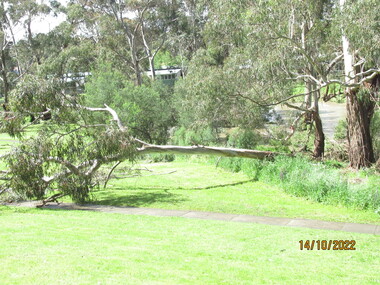
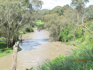
Photograph - Photograph - Digital Image, Peter Simmenauer, Plenty River floods near Plenty Lane 2022, 14/10/2022
Plenty River in flood near Plenty Lane Greensborough, October 2022. Colour digital photographDate stamped: 14/10/2022plenty lane greensborough, plenty river, floods -
 Greensborough Historical Society
Photograph - Photograph - Digital Image, Peter Simmenauer, Plenty River floods near Plenty Lane 2022, 14/10/2022
Plenty River in flood near Plenty Lane October 2022 Greensborough. Colour digital photographDate stamped: 14/10/2022plenty lane greensborough, plenty river, floods -
 Ringwood and District Historical Society
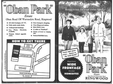
Flyer, Land Sale Advertisement, Oban Park Estate, Ringwood, Vic. - 1969
One double-sided and two single-sided pages advertising Oban Park Estate land sale, including terms of sale, locality map, subdivision features and summary of local services.Subdivision includes Oban Road, Terrigal Close, Dorelaw Drive (later Melview Drive), Naroo Court, Barook Court, and Lockhart Road. Agents in Conjunction: E. Wachman, Melbourne, Hutchinson Real Estate, Ashwood, and A.W. Dickson, 136 Whitehorse Road, Ringwood (Phone) 870-6007 A.H. 882967. Separate newspaper advertisement (digital only) shows agents - Hutchison Real Estate (Telephone 277-2326) and Michelson Gelfand Pty Ltd (Telephone 53-8151). -
 Greensborough Historical Society
Booklet, Yarra Plenty Regional Library, Learning strategic framework 2015-2020, 2016_
Yarra Plenty Regional Library has identified Learning as one of the core activities of the library service. This Learning Strategic Framework follows on from the YPRL Strategic Plan 2013-17. Goals and priorities are laid out in this booklet.34p., colour illus.yarra plenty regional library, yprl, learning activities, education -
 Eltham District Historical Society Inc
Audio - Audio Compact Disc, Neisha Forbes, Neisha Forbes, Plenty Historical Society with Marie Ryan on Magazine, Plenty Valley FM Radio, 22 December 2005
Neisha Forbes of Plenty Historical Society, speaking with host Marie Ryan of Magazine, on Plenty Valley FM Radio about Plenty, the Plenty Historical Society and the Sutherland homes as well as a brief review of the recent presentations held at the Eltham Living and Learning Centre as part of the Tales of Old Nillumbik presentations.audio recording, plenty, plenty historical society, sutherland homes -
 Malmsbury Historical Society
Photograph (Item), Township Of Malmsbury (1879), Malmsbury
Buildings - Township -
Ringwood and District Historical Society
Newspaper Cutting, Maroondah Journal, Ringwood Primary School to Federation Estate Development - Cutting. 1998, 1998
Ringwood Primary School was closed in 1996 and building redevelopment commenced. The Federation Estate was created and became a home to community groups including the Eastern Volunteer Resource Centre.Article about Ringwood Primary School being developed into Federation Estate. Cutting from Maroondah Journal. +Additional Keywords: Gurr, Peter (Councillor)School gains new lease of life -
 Kew Historical Society Inc
Plan - Subdivision Plan, J R Mathers & McMillan, Normanby Estate, c.1913
The Kew Historical Society's map collection includes a substantial number of real estate subdivision plans, mainly of Kew but also of surrounding suburbs in Melbourne. Most of the subdivision plans date from the 1920s and 1930s when the districts old homes and local farmland were being split up to accommodate residential growth in the postwar period. These early plans were assembled by a local firm, Jas R Mather & McMillan, which had an office in Cotham Road. Many of the plans, and sometimes photos, were annotated by the agents.Subdivision plans are historically important documents used as evidence for the growth of suburbs in Australia. They frequently provide information about when the land was sold as well as evidence relating to surveyors and real estate and financial agents. The numerous subdivision plans in the Kew Historical Society's collection represent working documents, ranging from the initial sketches made in planning a subdivision to printed plans on which auctioneers or agents listed the prices for which individual lots were sold. In a number of cases, the reverse of a subdivision plan in the collection includes a photograph of a house that was also for sale by the agent. These photographs provide significant heritage information relating house design and decoration, fencing and household gardens.The photograph may also be aesthetically significant depending on the importance of the photographic atelier.The Normanby Estate, which was adjacent to Normanby Road, Kew East, included thirty-one lots for sale. Streets on the subdivision plan include Adeney Avenue, Park Hill Road, Normanby Road, Weir Street and Wharton Street. Cotham Road and its tramway are shown nearby. The plan is interesting as it shows Wharton Street, named after the architect and town planner George Wharton, who was the first chairman of the Municipality of Kew. The street was to later be renamed Cecil Street. Also shown are proposed ‘Municipal Gardens’ where Parkhill Drive is now located."D" in top left corner. Stamped auctioneers contact details: "Jas. R. Mathers & Son & McMillan / Auctioneer & Land Salesmen, / 271 Collins Street / Melbourne" and Jas. R. Mathers / Estate & Financial Agent / Cotham Road / Kew".weir street - kew, wharton street - kew, normanby road - kew, cotham road - kew, municipal gardens - kew, park hill parkhill road - kew, braemar - kew, subdivision plans - kew