Showing 10706 items matching "projects"
-
 Whitehorse Historical Society Inc.
Photograph, Eastlink
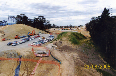
Five coloured photos of the Eastlink Project at the Deep Creek Road site, Mitcham on 23 August 2006eastlink, thiess-john holland, deep creek road mitcham -
 Whitehorse Historical Society Inc.
Photograph, Eastlink
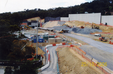
Three Coloured photos of the Eastlink project at the Deep Creek Road site, Mitcham -25th October 2006eastlink, thiess - john holland, deep creek road mitcham -
 Whitehorse Historical Society Inc.
Photograph, Eastlink
Two coloured Photos of the Eastlink Project at the Deep Creek Road site, Mitcham on 6th December 2006eastlink, thiess-john holland, deep creek road mitcham -
 Whitehorse Historical Society Inc.
Photograph, Eastlink
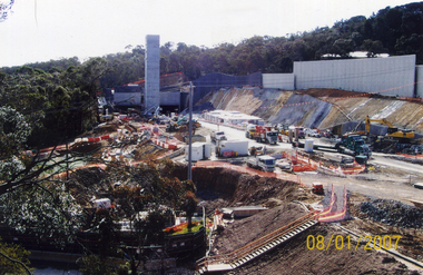
Four coloured photos of the Eastlink project at Deep Creek Road site, Mitcham on 8th Jan 2007eastlink, thiess john holland, deep creek road, mitcham -
 RMIT Design Archives
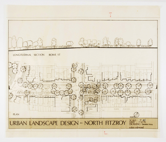
Architectural drawings, Urban Landscape Design - North Fitzroy
Detailled Area plan of the Urban Renewal Project in North Fitzroy. Features the longitudinal section at Rowe St.ink, acetate -
 Queen Victoria Women's Centre
Bookmark, The Shilling Wall & Garden, c. 2008
series of bookmarks made for centre promotion. Cardboard double sided bookmark. Front depict shilling wall artwork and on the back information about the project. -
 University of Melbourne, Burnley Campus Archives
Work on paper - Student Work, Street Trees That Merit Attention in Melbourne, 25.10.1993
arboriculture, assignment, trees, philip kenyon -
 Melbourne Tram Museum
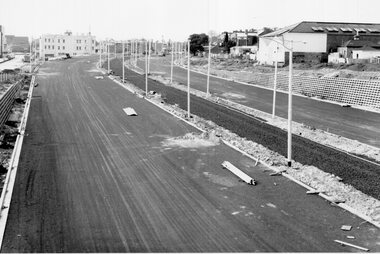
Photograph - Black & White Photograph/s, Melbourne & Metropolitan Tramways Board (MMTB), late 1968
Black and white photographs of the preparation for track laying in Queensway - St Kilda Junction project late 1968.trams, tramways, trackwork, rails, track materials, track repairs, sleepers, equipment, queensway -
 Lakes Entrance Historical Society
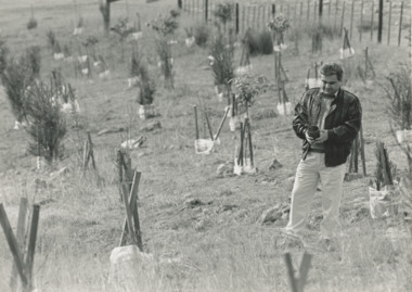
Photograph, BHP revegetation project, East Gippsland Victoria, 1995 c
Black and white photograph of representative from BHP at revegetation project funded by BHP East Gippsland Victoriaoil and gas industry -
 Ringwood and District Historical Society
Photograph, Composite Aerial Views of Ringwood, Victoria - 1972
Two composite black & white aerial photographs with north-facing view over Maroondah Highway, including Railway Station precinct, Civic Centre precinct, Eastland, Mount Dandenong Road, Bedford Road, Ringwood Street, Warrandyte Road, Mullum Road, Loughnan's Road.Department of Crown Lands and Survey. Maroondah Highway Project - Run 3 - 20.1.72 - 3,900' ASL. -
 St Kilda Historical Society
Photograph - Photo map, 30/01/1960
One of a series of photo-maps produced for the Department of Crown Lands and Survey (1857-1983). For correlation with a current map, and access to other historical photo maps of Victoria, see the Historic Photo-Maps Index published by the Department of Environment, Land, Water and Planning at https://services.land.vic.gov.au/DELWPmaps/historical-photomaps/Black and white aerial photographVic 1093-62 Melbourne & Metropolitan Project Run 21 30.1.60 Lens 10" 8.200middle park, albert park, catani gardens, st kilda west, 1960 -
 St Kilda Historical Society
Photograph - Photo map, 30/01/1960
One of a series of photo-maps produced for the Department of Crown Lands and Survey (1857-1983). For correlation with a current map, and access to other historical photo maps of Victoria, see the Historic Photo-Maps Index published by the Department of Environment, Land, Water and Planning at https://services.land.vic.gov.au/DELWPmaps/historical-photomaps/Black and white aerial photographVic 1093-60 Melbourne & Metropolitan Project Run 21 30.1.60 Lens 10" 8.200st kilda, albert park, prahran, windsor, south yarra, 1960 -
 St Kilda Historical Society
Photograph - Photo map, 30/01/1960
One of a series of photo-maps produced for the Department of Crown Lands and Survey (1857-1983). For correlation with a current map, and access to other historical photo maps of Victoria, see the Historic Photo-Maps Index published by the Department of Environment, Land, Water and Planning at https://services.land.vic.gov.au/DELWPmaps/historical-photomaps/Black and white aerial photographVic 1092-36 Melbourne & Metropolitan Project Run 22 30.1.60 Lens 10" 8.200st kilda, st kilda pier, st kilda beach, catani gardens, 1960 -
 St Kilda Historical Society
Photograph - Photo map, 30/01/1960
One of a series of photo-maps produced for the Department of Crown Lands and Survey (1857-1983). For correlation with a current map, and access to other historical photo maps of Victoria, see the Historic Photo-Maps Index published by the Department of Environment, Land, Water and Planning at https://services.land.vic.gov.au/DELWPmaps/historical-photomaps/Black and white aerial photographVic 1092-38 Melbourne & Metropolitan Project Run 22 30.1.60 Lens 10" 8.200st kilda, st kilda beach, st kilda pier, catani gardens, 1960, st kilda botanical gardens, peanut farm -
 St Kilda Historical Society
Photograph - Photo map, 30/01/1960
One of a series of photo-maps produced for the Department of Crown Lands and Survey (1857-1983). For correlation with a current map, and access to other historical photo maps of Victoria, see the Historic Photo-Maps Index published by the Department of Environment, Land, Water and Planning at https://services.land.vic.gov.au/DELWPmaps/historical-photomaps/Black and white aerial photographVic 1092-40 Melbourne & Metropolitan Project Run 22 30.1.60 Lens 10" 8.200st kilda east, balaclava, ripponlea, st kilda cemetery, 1960 -
 St Kilda Historical Society
Photograph - Photo map, 30/01/1960
One of a series of photo-maps produced for the Department of Crown Lands and Survey (1857-1983). For correlation with a current map, and access to other historical photo maps of Victoria, see the Historic Photo-Maps Index published by the Department of Environment, Land, Water and Planning at https://services.land.vic.gov.au/DELWPmaps/historical-photomaps/Black and white aerial photographVic 1092-42 Melbourne & Metropolitan Project Run 22 30.1.60 Lens 10" 8.200malvern, caulfield, caulfield park, 1960 -
 St Kilda Historical Society
Photograph - Photo map, 30/01/1960
One of a series of photo-maps produced for the Department of Crown Lands and Survey (1857-1983). For correlation with a current map, and access to other historical photo maps of Victoria, see the Historic Photo-Maps Index published by the Department of Environment, Land, Water and Planning at https://services.land.vic.gov.au/DELWPmaps/historical-photomaps/Black and white aerial photographVic 1091-112 Melbourne & Metropolitan Project Run 23East 30.1.1960 Lens 10" 8.200elwood, point ormond, elwood park, elwood canal, 1960 -
 St Kilda Historical Society
Photograph - Photo map, 30/01/1960
One of a series of photo-maps produced for the Department of Crown Lands and Survey (1857-1983). For correlation with a current map, and access to other historical photo maps of Victoria, see the Historic Photo-Maps Index published by the Department of Environment, Land, Water and Planning at https://services.land.vic.gov.au/DELWPmaps/historical-photomaps/Black and white aerial photographVic 1091-110 Melbourne & Metropolitan Project Run 23East 30.1.60 Lens 10" 8.200elwood, elsternwick, elsternwick park, ripponlea, st kilda east, caulfield, balaclava, 1960 -
 St Kilda Historical Society
Photograph - Photo map, 30/01/1960
One of a series of photo-maps produced for the Department of Crown Lands and Survey (1857-1983). For correlation with a current map, and access to other historical photo maps of Victoria, see the Historic Photo-Maps Index published by the Department of Environment, Land, Water and Planning at https://services.land.vic.gov.au/DELWPmaps/historical-photomaps/Black and white aerial photographVic 1091-1 Melbourne & Metropolitan Project Run 24East 30.1.60 Lens 10" 8.200elwood, elwood beach, elwood park, 1960 -
 St Kilda Historical Society
Photograph - Photo map, 30/01/1960
One of a series of photo-maps produced for the Department of Crown Lands and Survey (1857-1983). For correlation with a current map, and access to other historical photo maps of Victoria, see the Historic Photo-Maps Index published by the Department of Environment, Land, Water and Planning at https://services.land.vic.gov.au/DELWPmaps/historical-photomaps/Black and white aerial photographVic 1091-2 Melbourne & Metropolitan Project Run 24East 30.1.60 Lens 10" 8.200elwood, elwood park, elwood beach, elsternwick park, 1960 -
Clunes Museum
Education kit - SCHOOL PROJECT
.1 FAMILY HISTORY OF RALPH COUNDAN BY SARAH CULES .2 ADDRESS UNKNOWN APROJECT BY JESSICA DANKS .3 LOG BOOK BY GEORGIE BARRETT 2001 .4 CLUNES PROJECT BY JESS DOHNT .5 SCHOOL PROJECT BY SARAH CULES - LETTERS FROM RALPH COUNDANwesley college clunes, clunes campus -
 Whitehorse Historical Society Inc.
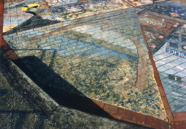
Photograph, Nunawading Primary Schools Community Art Project -2004-5, 1/06/2005 12:00:00 AM
See ND5890One of a set of 19 coloured photographs relating to the Ceramic Tile Project by the Nunawading Primary Schools Community Art Project which was installed in the Amphitheatre at the rear of the Nunawading Civic Centre. This photo relates to Laburnum Primary School, part of the project.Text, Plans & Publicity - see ND5890nunawading primary schools community art project., city of whitehorse. civic centre, ceramic tile project, laburnum primary school no 4863 -
 Vision Australia
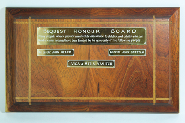
Object, Bequest Honour Board
Bequest Honour Board. Many projects which provide invaluable assistance to children and adults who are blind or vision impaired have been funded by the generosity of the following people. Mr Leslie John Beard. Mr Oriel John Grattan. Vica & Mitia Yavitch1 wooden tablet with 4 engraved gold coloured nameplatesBequest Honour Board. Many projects which provide invaluable assistance to children and adults who are blind or vision impaired have been funded by the generosity of the following people. Mr Leslie John Beard. Mr Oriel John Grattan. Vica & Mitia Yavitch.royal victorian institute for the blind, leslie beard, oriel grattan, vica & mitia yavitch -
 Bendigo Historical Society Inc.
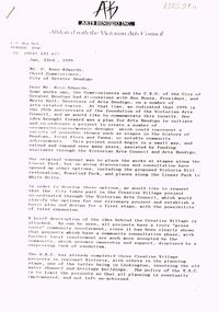
Document - MERLE HALL COLLECTION: THE 'CREATIVE VILLAGE' PROJECT 1995
Documents re the 1995 'Creative Village' Project. - a. letter of approach from AB to Mr P Ross-Edwards, Chief-Commissioner CoGB re project 23/1/1995; b. letter from John Little, Administrator, Victorian Arts Council, to AB granting application for $5190 for project; c. AB single-sheet notice (date 5/9/1995) re the presentation of the Report by the Creative Village Team on 21/9/1995. -
Bendigo Historical Society Inc.
Document - Sir John Quick Committee Minutes, Michele Matthews Collection, 23.6.1999
The Sir John Quick Committee was formed in 1991 to commemorate the achievements of Sir John Quick who played a prominent role in the federation of Australia. The Committee aimed to raise awareness of the contribution of Sir John Quick and to ensure that he was recognized for the part he played.Agenda for meeting of the Sir John Quick Committee held on 22.6.1999 with correspondence and reports. Five typed pages on white paper. Report from Secretary re latest updates for the Sir John Quick Museum Project. Letter to Secretary (Les Roberts) from Hadley Sides, re application for funding for the Centenary of Federation Project. dated 1.7.1998. Letter to John Balsillie re next steps for the Sir John Quick Federation project after funding approved.sir john quick committee, federation project, sir john quick federation project. -
Port Melbourne Historical & Preservation Society
Archive - File, Bayside Project Bill, Ewan Ogilvy's Bayside Papers, Box Three, 1987
Ewan Ogilvy, former Melbourne Councillor and also of Community Services Victoria, Inner Urban Ministerial Advisory Committee and Uniting Church's Centre for Urban Research and Action (CURA), was instrumental in social justice approaches to town planning. He and CURA's Social Justice and the City Project funded Port Melbourne community groups protesting against the SCDC development in 1987. His files were presented to the Society in May 2001 on his preparation for leaving Victoria.From Ewan Ogilvy's chronologically organised 'Bayside Papers' relating to the proposed development of Port Melbourne industrial land in the late 1980s: Bayside Project Bill documents including VP Hansard, copy of Act and of memorandum (a and b) plus related correspondence and documents, bound in clear fileSigned 'Ewan Ogilvy'town planning, town planning - proposals shelved - bayside, public action campaigns, environmental issues, public housing, missions to seamen, ewan ogilvy, centre for urban research and action, sandridge city development co pty ltd, scdc, linton r lethlean, barry pullen - mlc -
NMIT (Northern Melbourne Institute of TAFE)
Report: Reporting student performance in TAFE CCOT September 1987
One hundred and forty page A4 size report with yellow cover. Spiral bound. Subtitle: A Research Report prepared for The Victorian Technical and Further Education Board. Project Managers: Ross Gillespie and Kieran Batt. Project Research: Roslyn Verity. Produced by Collingwood College of TAFE.collingwood college of tafe, reports, nmit -
Phillip Island and District Historical Society Inc.
Book, Heritage Collections Council, Significance : a guide to assessing the significance of cultural heritage objects and collections, 2001
At foot of title: "A Heritage Collections Council project undertaken by Roslyn Russell of Australian Heritage Projects and Kylie Winkworth" Includes bibliography. Also available in PDF format via the Internet at: http:/?/?www.amol.org.au/?craft/?publications/?hcc/?significance/?significance.asp.cultural property, protection, australia, museums, collection management -
 National Wool Museum
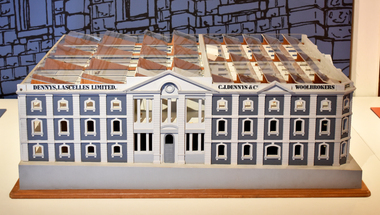
Dennys Lascelles Woolstore Building Model, 1988
Wooden 1-50 Scale model of the Dennys Lascelles WoolstoreOn plaque - 1-50 Scale Model of The Dennys Lascelles Woolstore / Cnr Moorable & Brougham sts, Geelong, Which will house the National Wool Centre - Geelong / The Centre is a project of the Geelong Regional Commission and is Geelongs major bicentinnial celebratons project -
Federation University Historical Collection
Letter, Letter to Professor David James from Dato F. S. Lau regarding a joint project
Professor David James was the inaugural Vice Chancellor of University of Ballarat which is a predecessor of Federation University A4 typed letter Professor David James from Dato F. S. Lau regarding a joint projectdavid james, dato f.s. lau, university of ballarat, malaysia, tan sri datuk, dr augustine ong