Showing 3448 items
matching road bridges
-
 The Beechworth Burke Museum
Photograph
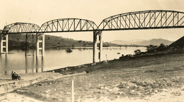
... road bridge in Australia at the time of its completion... in 1936. At 2430 feet long, Bethanga Bridge was the longest road ...Taken between 1928 and 1930, depicted is the Bethanga Bridge under construction. The Bridge was completed in 1930 and was built to assist residents of the Bethanga district to travel to Albury. Other bridges would become submerged by the backed-up water of the Murray and Mitta Rivers so the Bethanga bridge was built two miles above the Mitta Weir. The Bethanga Bridge was built north of the future Hume Dam which would be completed in 1936. At 2430 feet long, Bethanga Bridge was the longest road bridge in Australia at the time of its completion. The Bridge is 20 feet wide and made up of nine 270 feet long spans. Materials used include ten tons of paint for the steel works; 1600 tons of steel; 900 tons of timber for the decking; and reinforced concrete for the piers. The tender for the construction was awarded to C. Ruwolt Pty. Ltd., engineers who were located on Victoria Street, West Richmond. The contract was awarded for £71,890. It was predicted between 250 and 300 men would find employment on the project. The news was well received by trade unions at the time as there had been a drop in available engineering work.This photograph is historically significant as it depicts the progress of the Bethanga Bridge construction, which was important infrastructure for the area. It is also a good example of methods used in the area to assist in travel over the river prior to the construction of the Hume Dam.Black and white rectangular photo printed on matte photographic paper.Reverse: 1997 3186 / 84-19-3 / This is the bridge. / It is not yet open to traffic / yet. will not be completed / until May next / It is a wonderful bridge the / pillars are 100 feet high. / KODAK PRINT Envelope Obverse: Peterson PHOTO / Hume Weir Envelope Reverse: BMM 84-20-1,2+3. bethanga bridge, lake hume, hume dam, hume weir, murray river, bridge, bethanga, albury -
 Whitehorse Historical Society Inc.
Photograph, Deep Creek Road, Mitcham, 1/01/2001
... Road on left. Taken before work started on new bridge and road.... before work started on new bridge and road. Deep Creek Road ...Black and white photograph of Deep Creek Road, taken from lower entrance of Schwerkolt Cottage Reserve showing Glenvale Road on left. Taken before work started on new bridge and road.deep creek road, mitcham, glenvale road, ringwood -
 Phillip Island and District Historical Society Inc.
Photograph
... Phillip Island Suspension Bridge - 1st road connection...-island-and-the-bass-coast Phillip Island Suspension Bridge - 1st ...Phillip Island Suspension Bridge - 1st road connection between Phillip Island and the mainland at San Remo 1938. Part of an album compiled and donated by Mrs Helen Jansson.Phillip Island Suspension Bridge.Descriptive caption adjoining this photo print, also the previous one.local history, photography, photographs, slides, film, civil engineering, bridges, phillip island bridge, black & white photograph, mrs. helen jansson, suspension bridges, phillip island -
 Federation University Historical Collection
Plan, Underground Workings New Australasian Company Creswick, not dated
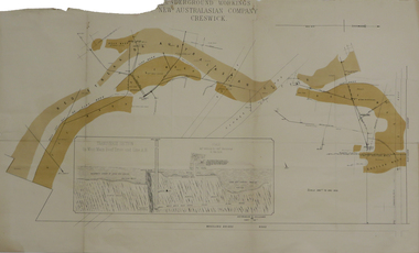
... Mine at Creswick, showing Wheeler's Bridge Road, a transverse... plans cgt creswick new australasian company wheeler's bridge red ...A plan of the underground working of the New Australasian Mine at Creswick, showing Wheeler's Bridge Road, a transverse section on the West Main Reef Drive and Line AB. It als shows the locations of the Red streak or Australasian Gutter, Reef wash, Eastern Wash, Australasian and Eaglehawk Shaft and prospecting drives.mining, plans, cgt, creswick, new australasian company, wheeler's bridge, red streak gutter, australasian gutter, reef wash, eastern wash, australiasian shaft, eaglehawk shaft -
 Bendigo Historical Society Inc.
Newspaper - JENNY FOLEY COLLECTION: CLOSED
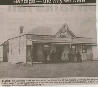
... -Goornong and Russells Bridge roads. A licence to allow the sale...-Goornong and Russells Bridge roads. A licence to allow the sale ...BHS CollectionBendigo Advertiser ''The way we were'' from 2003. Closed: the Ellesmere hotel was situated at the intersection of the Axedale-Goornong and Russells Bridge roads. A licence to allow the sale of Victorian beer only was granted to Michael Slattery in 1870. the hotel was de-licensed on December 31, 1914. The clip is in a folder.newspaper, bendigo advertiser, the way we were -
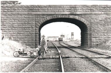 Hume City Civic Collection
Photograph, Pre 1989
... road over rail bridge...The bluestone 'road over rail' bridge at Macedon Street... melbourne The bluestone 'road over rail' bridge at Macedon Street ...The bluestone 'road over rail' bridge at Macedon Street is of state architectural, architectural, historical and engineering significance. It spans the first government regional railway. Its design and building was done according to strict English standards and made use of a bridge crossing instead of a level road crossing.A black and white photograph of a stone bridge with an eliptical arch spanning two rail tracks. A workman is standing between one set of tracks in the foreground and a railcart is next to the tracks. The station, footbridge and water tower are visible through the arch.road over rail bridge, bridges, sunbury railway station, water towers, pedestrian bridges, stone bridges, george evans collection -
Phillip Island and District Historical Society Inc.
Photograph
... Phillip Island Suspension Bridge. First road connection...-island-and-the-bass-coast Phillip Island Suspension Bridge. First ...Phillip Island Suspension Bridge. First road connection to mainland at San Remo. built 1938/40, demolished 1970. Part of an album compiled and donated by Mrs Helen Jansson.Print of approach to Phillip Island suspension Bridge. Shows second Bridge without middle span in background.local history, photography, photographs, slides, film, civil engineering, bridges, phillip island bridges, black & white photograph, mrs helen jansson, phillip island bridge -
 Greensborough Historical Society
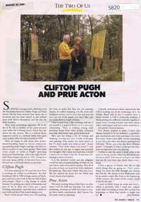
Newspaper Clipping, Jane Freeman, Clifton Pugh and Prue Acton, by Jane Freeman, 20/08/1989
... ' on the Cottles Bridge-Strathewen Road between Hurstbridge and Arthur's...Greensborough Historical Society 34A Glenauburn Road Lower ...Relationship between Clifton Pugh and Prue Acton based on their common interest in painting. Clifton Pugh lived at 'Dunmoochin' on the Cottles Bridge-Strathewen Road between Hurstbridge and Arthur's Creek.Text and col. photographclifton pugh, prue acton, painters, hurstbridge -
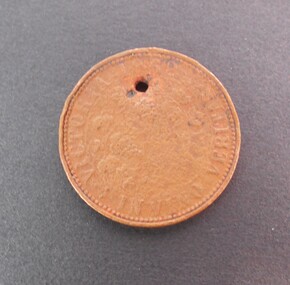 Bendigo Historical Society Inc.
Memorabilia - TRADE TOKEN
... Copper token on obverse R.B. Ridler 187 Bridge Road... Bridge Road, Richmond, Reverse: Victoria 1862 ''In Vino Veritas ...Copper token on obverse R.B. Ridler 187 Bridge Road, Richmond, Reverse: Victoria 1862 ''In Vino Veritas''. The token is very well worn and difficult to read. It has an hole for possibly been worn around the neck. It was found at the back of 191 (?) Arnold Street, milkbar shop in a dilapidated stable.numismatics, tokens, r.b. ridler -
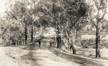 Eltham District Historical Society Inc
Photograph - Photograph postcard, The Rose Stereograph Company, View at Eltham, Vic. Postcard sent from Ernest and family to Joe, 3 May 1936, c.1920
... main road bridge... the original Main Road Bridge and the Diamond Creek from near... the original Main Road Bridge and the Diamond Creek from near ...Postcard sent from Ernest and family to Joe, 3 May 1936. Original photo estimated to be circa 1920. Looking west across the original Main Road Bridge and the Diamond Creek from near the intersection of Antoinette Boulevard. To the right of the bridge appear to be orchard trees in flood waters. The long wooden suspension bridge over the Diamond Creek on Main Road at Eltham collapsed during flooding of the Diamond Creek on October 13 and 14, 1923. The original bridge was built around 1840 for the coach road when Cobb & Co.'s coach was the only conveyance between Eltham and Melbourne. Widespread damage was done in Melbourne and surrounding areas by floods resulting from the overflow of the Yarra at many points along its banks. A temporary bridge rigged up was severely damaged by the flooding of the creek and was closed to vehicular traffic in April 1924. A new concrete bridge was constructed to replace it and by May 1926 all the concrete piles and abutments had been completed. The bridge was finally completed and opened for traffic in September 1926, almost three years after it initially collapsed. The Rose Series P. 4346 Postcards scanned from the collection of Michael Aitken on loan to EDHS, 13 Feb 2018Digital file only Postcards scanned from the collection of Michael Aitken on loan to EDHS, 13 Feb 2018michael aitken collection, postcards, main road bridge, main road, eltham, antoinette boulevard, diamond creek (creek), eltham south -
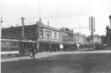
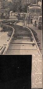 Melbourne Tram Museum
Newspaper, The Age, track reconstruction work in Bridge Road Richmond, c1974
... track reconstruction work in Bridge Road Richmond,... track reconstruction work in Bridge Road Richmond, between... reconstruction work in Bridge Road Richmond, between Burnley St ...Newspaper clipping from an undated Melbourne page, about track reconstruction work in Bridge Road Richmond, between Burnley St and the Yarra River. Shows the temporary trackwork slew along the road with a long line of cars alongside. In the distance is a tram showing Kew Depot, route 23. Work c1974.trams, tramways, bridge rd, trackwork, route 23, temporary track -
Eltham District Historical Society Inc
Document - Folder, Mitton, John
... Mittons Bridge Road... in the early 1840s. There is a Mittons Bridge Road at St Andrews... in the early 1840s. There is a Mittons Bridge Road at St Andrews ...John Mitton reportedly in the Hurstbridge St Andrews area in the early 1840s. There is a Mittons Bridge Road at St Andrews. Contents Letter from G L Mitton seeking any information about her husband's great grandfather John Mitton who was in the Hurstbridge St Andrews area in the early 1840s.Newspaper clippings, A4 photocopies, etcjohn mitton, mittons bridge road -
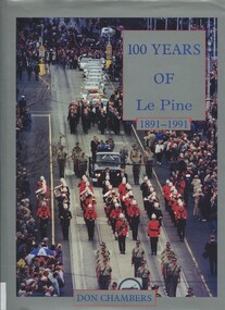 Surrey Hills Historical Society Collection
Book, One hundred years of Le Pine 1891 - 1991, 1994
... of Bridge Road, Richmond. Graham Coward, Regional Manager of Le Pine... business of Joseph Le Pine of Bridge Road, Richmond. Graham Coward ...This is the story of the development of Le Pine Services as it exists in the year 1991, beginning with its historical roots in the original small family undertaker's business of Joseph Le Pine of Bridge Road, Richmond. Graham Coward, Regional Manager of Le Pine, spoke at a Surrey Hills Historical Society meeting in 2000 and donated the book.202p; 4p of plates; ill; includes loose leaf pages of notes relating to Surrey HillsKINDLY PRESENTED / BY GRAHAM COWARD / LE PINES / JUNE 2000le pine funeral services, undertakers, funeral directors -
 Melbourne Tram Museum
Document - Tour notes, Keith Kings, Adult Education Association, 9/1971
... - Spencer St, Bridge Road Richmond, Hawthorn, Malvern, Queensway... St, Bridge Road Richmond, Hawthorn, Malvern, Queensway ...Set of tour notes using tram L class 104. Gives details of the tram used, South Melbourne depot, cable trams, the route - Spencer St, Bridge Road Richmond, Hawthorn, Malvern, Queensway, Ackland St, St Kilda, and return to South Melbourne depot. Prepared by Keith Kings and the TMSV.Demonstrates a set of tour notes for a non-tramway enthusiast group,Tour notes - two Foolscap sheets for a tour by the Adult Education Association Historical Group of Vic - 12-9-1971trams, tram tours, tours, tour notes, south melbourne depot, adult education assoc -
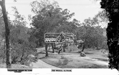 Eltham District Historical Society Inc
Negative - Photograph, The Rose Stereograph Company, The Bridge, Eltham, c.1939
... main road bridge...Looking west across the Main Road Bridge over the Diamond... melbourne Looking west across the Main Road Bridge over the Diamond ...Looking west across the Main Road Bridge over the Diamond Creek at Eltham, c.1939. The car in the foreground, possibly the photographer's, is a Ford Model C Ten built by Ford UK between 1934 and 1937. The Model C was released in Australia in 1935. The Ford Model C Ten is a car that was built by Ford UK between 1934 and 1937. The Model C was released in Australia in 1935 https://en.wikipedia.org/wiki/Ford_Model_C_Ten This glass plate negative was used to manufacture postcards (1:1 printing) for commercial sale by the Rose Sterograph Company and its subsidiaries. George Rose founded the Rose Stereograph Company in 1880 and was joined by Herbert (Bert) Cutts in the early 20th Century. The pair formed a lifetime working partnership and strong personal friendship. Assisted by George’s two sons, Herbert George and Walter, and later by Neil Cutts, the Rose Stereograph Company continued its operations for more than 140 years. The company was initially built on stereographs, but as cinema took over and stereographs fell out of fashion, the Rose Stereograph Company developed Australia’s first commercially viable photographic postcard business. Specialising in postcards of iconic historical moments and significant landmarks, The Rose Stereograph Company became a staple of the Australian travel industry.This remarkable collection of glass plate negatives, transparencies, and postcards – arguably Australia’s most significant photography collection outside of public hands – has been passed down through the generations, surviving war, relocation, and the harsh Victorian climate. The historic Rose Stereograph collection is the culmination of George Rose’s dream of capturing and preserving precious moments in time and remains the legacy of the Rose and Cutts families. It is with great sadness that the Cutts family says goodbye to a collection that spans five generations and 140 years. The Cutts family understands that for these historically important pieces to rest with one family is to deny others the pleasure of their custodianship.Glass Plate Negative Size: 9 x 13.9 cmThe Bridge, Eltham, Valentine Series No. 3196, Copyrightpeter and elizabeth pidgeon collection, bridge, cars, diamond creek (creek), eltham, eltham south, ford model c ten, glass plate negative, main road, main road bridge, motor vehicles, postcard, rose stereograph, rose stereograph company, valentine series postcard -
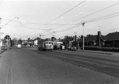 Ballarat Tramway Museum
Photograph - Black & White Photograph/s, mid to Late 1965
... Bridge Road... of Hoddle St/Punt Rd and Bridge Road Richmond late 1965. On Kodak... Parade Ballarat Ballarat goldfields trams tramways Bridge Road ...Set of seven Black and white photographs of the arrangements and work for the track reconstruction at the intersection of Hoddle St/Punt Rd and Bridge Road Richmond late 1965. On Kodak paper. 1420.1 - Bridge Road looking east at River St. crossover (Hawthorn bridge in distant background). Tram-bus connection at a weekend. Note driver's uniform. Conductor walking to bus with passengers. Conductors often worked through on the bus and next tram at this time to save crews. 1420.2 - Bridge Road at Punt Rd and Hoddle St. intersection looking north west. Reconstruction of curves. Would probably be a Sunday given that new rails are in situ. 1420.3 - Ditto - looking south east 1420.4 - looking south east 1420.5 - looking east - replacement bus service passing with old cable winding house in the background. Concrete being placed. 1420.6 - Wellington Parade at Simpson St. crossover looking east. Bus-tram connection. Bus 542 and tram 966 (Kew Depot) 1420.7 - ditto - bus 570 and tram 850 (Camberwell). See P.Winspur note - see data sheet for Reg. item 1418.trams, tramways, bridge road, tram - bus connections, trackwork, mmtb, tram 939, tram 966, tram 850 -
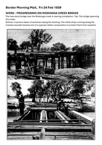 Wodonga & District Historical Society Inc
Photograph - Wodonga Creek Stock Bridge Collection
... bitumen roads and traffic bridges to the Wodonga Saleyards, where... bitumen roads and traffic bridges to the Wodonga Saleyards, where ...The Wodonga Creek Stock Bridge was constructed by the Country Roads Board in 1939. The date was recorded on a small plaque attached to one of the trestles. The bridge is an important reminder of one of the industries Wodonga was built on — cattle. It was constructed to develop a new stock route between Albury and Wodonga which would direct cattle away from the main bitumen roads and traffic bridges to the Wodonga Saleyards, where thousands of sheep and cattle were sold each month. It is a moderately tall timber trestle road bridge consisting of nine spans, with a deck length of 76 metres and deck width of 4.5 metres, and a maximum span length of 8.5 metres. The substantial timber deck featured decking laid horizontally and longitudinal running planks laid on top of it. The bridge also has timber side safety rails to discourage livestock from straying over the side. The bridge also became the centre of summer social activity for the young people of Wodonga as the area became a gazetted swimming area before the Wodonga Swimming Pool was constructed in 1959. In 1980 the Wodonga Saleyards were relocated to Bandiana to the east of the city. This meant that Wodonga Creek Stock Bridge was no longer needed for its original purpose. Although listed as a significant site by the Victorian Heritage and National Heritage Trust on 3/08/1998, the bridge fell into disrepair and also suffered damage from several floods. A suspension Bridge was constructed beside the Stock Route Bridge in 2013 and the old bridge was closed to traffic. Major damage caused by several floods, including a major flood in 2022 has resulted in the bridge being unsafe and its future is uncertain. The model of the Wodonga Creek Stock Bridge in our Collection made by Mr John Wild, depicts its current condition.The Wodonga Creek Stock Bridge is significant for technical, historic and social reasons and has been registered at the State Heritage level. It is of technical significance as a nine span bridge with tall timber trestles. Large bridges of this type are now very rare in Victoria. It is of historic significance as a surviving structurally authentic bridge designed specifically for livestock and drover use, on a historic stock route. The Stock Bridge is of social significance for its location at a popular riverside leisure spot since its construction in 1939.A collection of photographic images depicting the Wodonga Creek Stock Bridge. It contains both black and white and coloured images taken at different times in the Stock Bridge's history. A model of the Bridge made for Our Society is also included.wodonga creek stock bridge, wodonga heritage -
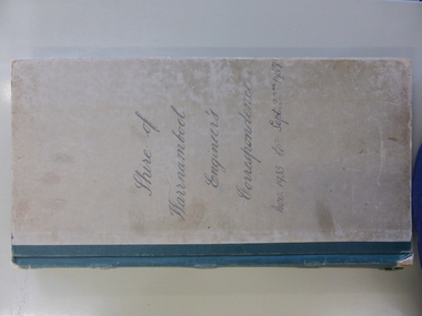
 Warrnambool and District Historical Society Inc.
Document - Ledger Shire of Warrnambool, Engineer’s Letter Book, 1939-1941, Circa 1939
... such as bridges, roads noxious weeds, drainage. It relates to areas... such as bridges, roads noxious weeds, drainage. It relates to areas ...This ledger contains outward correspondence from the Shire of Warrnambool, Engineer from the period 1939-1941. It covers matters such as bridges, roads noxious weeds, drainage. It relates to areas of the shire such as Belfast, Allansford, Garvoc, Laang, Naringal, Peterborough and Penshurst. It mentions people by the names of Coleman, Brennan, Dyson, Hurley, Jordan, Gray, Sadler.This collection of letters provides a very good overview of issues and work covered in the period 1939-1941.Dark grey mottled card cover with light brown binding. Contains 5 letters to page, index. The copies of letters sent are on pink paper and numbered 1-500.Engineering Department is written in black on spine of journal.shire of warrnambool, letterbook, engineers letterbook, warrnambool -
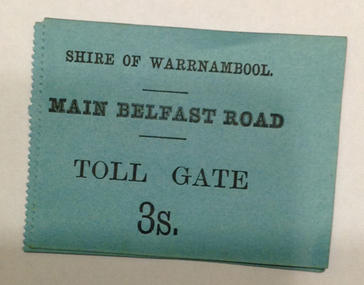
 Warrnambool and District Historical Society Inc.
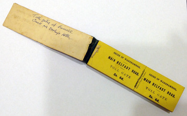
Certificate - Ticket Book, Main Belfast Road Toll, 2s 6d, 1860s
... Fairy) Road at Dennington Bridge, on the Woodford Road... Bridge, on the Woodford Road at Russells Creek and on the Geelong ...The Shire of Warrnambool operated toll gates from 1866 to 1869 as a means of revenue rai sing for road construction. There were three toll gate locations – on the main Belfast (Port Fairy) Road at Dennington Bridge, on the Woodford Road at Russells Creek and on the Geelong Road at the Allansford Bridge. The toll gates were unpopular and unprofitable for the lessees as travellers were able to avoid the tax by skirting around the gates. They had toll houses besides the gates. The printers of these tickets, Fairfax and Laurie were the lessees at the time of the Warrnambool Examiner newspaper. This paper, founded by Richard Osburne and John Wilkinson, and published with some gaps from 1851 to 1880, is a key source today of Warrnambool’s history at that time. These toll gates tickets are significant because:- 1. They date back to the 1860s and were only issued from 1866 to 1869. 2. They are the only artefacts we hold of the time when toll gates were operating in our local district 3. They are the best example of how the Shire of Warrnambool in its early history raised revenue for road building and maintenance This is a book of toll gate tickets for sale at the Main Belfast (Port Fairy) Road Toll Gate. The tickets (about 50) are yellow and in duplicate with provision to detach the outer ticket for the purchaser to keep. The tickets (two shillings and sixpence) are bound with an adhesive tape and the cover is mottled in pattern (brown and blue). There are also four loose tickets in blue (3 shillings). Back Cover: ‘136’ Tickets in book: ‘Shire of Warrnambool, Main Belfast Road, Toll Gate 2s 6d., Fairfax and Laurie, Printers’ Loose tickets: ‘Shire of Warrnambool, Main Belfast Road, Toll Gate, 3s.’ shire of warrnambool, toll gates -
 Warrnambool and District Historical Society Inc.
Document - Main Belfast Road Toll Gate Ticket Collection, 1860s
... Fairy) Road at Dennington Bridge, on the Woodford Road... Bridge, on the Woodford Road at Russells Creek and on the Geelong ...The Shire of Warrnambool operated toll gates from 1866 to 1869 as a means of raising revenue for road construction. There were three toll gate locations – on the main Belfast (Port Fairy) Road at Dennington Bridge, on the Woodford Road at Russells Creek and on the Geelong Road at the Allansford Bridge. The toll gates were unpopular and unprofitable for the lessees as travellers were able to avoid the tax by skirting around the gates. They had toll houses besides the tollgates. The printers of these tickets, William Fairfax and Henry Laurie, were the lessees at the time of the Warrnambool Examiner newspaper. This paper, founded by Richard Osburne and John Wilkinson, and published with some gaps from 1851 to 1880, is a key source today of Warrnambool’s history at the time. These toll gate tickets are significant because:- 1. They date back to the 1860s and were only issued from 1866 to 1869 2. They are the only artefacts we hold of the time when toll gates were operating in our local district 3. They are the best example of how the Shire of Warrnambool in its early history raised revenue for road building and maintenance. These are eleven toll gate tickets, ten for the Belfast (Port Fairy) Road toll gate and one for the Woodford Road toll gate. One is mounted on a Swintons store label (6 pence) and four are mounted on cardboard (2 shillings, sixpence, and two shillings and sixpence) and six are loose (three shillings, two shillings and sixpence and threepence). The Belfast Road tickets are yellow, green, blue and cream and the Woodford Road one is white. All have black printing. There is also an undated newspaper cutting with information on the toll gate tickets. Belfast Tickets: Shire of Warrnambool, Main Belfast Road, Toll Gate and the price Woodford Road: Shire of Warrnambool, Woodford Road, Toll Gate, 1s 6d Six of the eleven tickets also have ‘Fairfax and Laurie, Printers’ The sixpence ticket on card has the name R P Christian in ink written on the back of the card. shire of warrnambool, toll gates, r p christian, woodford road, main belfast road, swintons pty ltd -
Phillip Island and District Historical Society Inc.
Photograph
... Phillip Island Suspension Bridge - 1st Road connection...-island-and-the-bass-coast Phillip Island Suspension Bridge - 1st ...Phillip Island Suspension Bridge - 1st Road connection between Phillip Island and mainland, Newhaven to San Remo. Built 1938/40, demolished 1970. Part of an album compiled and donated by Mrs Helen Jansson.Print of the Phillip Island Suspension Bridge.Hand lettered descriptive caption adjoining this photo print.local history, photography, photographs, slides, film, civil engineering, bridges, phillip island bridge, black & white photograph, mrs. helen jansson, suspension bridges, phillip island -
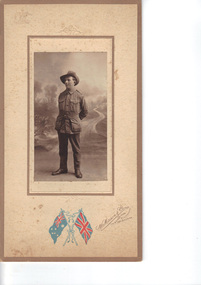 Emerald Museum & Nobelius Heritage Park
Photograph, Nightingale/Thompson Collection, c 1914 - 1918
... Mason & Co 144 Bridge Road Richmond, Melbourne embossed...144 Bridge Road, Richmond, Victoria, Australia... flags - Australia and UK with W Mason & Co 144 Bridge Road ...Photograph of young man in service uniform, identity: Victor George Thomson (1894 - 1948). Victor was the son of William Samuel Thompson and Elizabeth Alice Bishop. Victor was born in GembrookThompson CollectionSepia photograph of soldier on board with coloured flag logo of an embossed coat of armsMakers marks: coloured flags - Australia and UK with W Mason & Co 144 Bridge Road Richmond, Melbourne embossed Australian coat of Arms and embossed bows on top and bottom of photo. Inscription on back: Victor Thompson, my cousinthompson collection, nightingale -
 Lakes Entrance Historical Society
Photograph - Bridges, 1950
... bridge over the river, road to Paynesville under bridge, wharf..., railway bridge and highway bridge over the river, road ...Colour photograph of unfinished Cataraman Llinase on Mitchell River, at Bairnsdale Wharf, railway bridge and highway bridge over the river, road to Paynesville under bridge, wharf on left, Mt Taylor and Mt Lookout in background. Bairnsdale Victoriabridges, waterways, boats and boating -
 Sunbury Family History and Heritage Society Inc.
Photograph, Rosa McCall, Old Broadmeadows Township, 1949
... of a road way with a bridge in the foreground leading to a small... of a road way with a bridge in the foreground leading to a small ...The small town in the photograph is the former Broadmeadows Township (now part of Westmeadows). It was situated on the Old Sydney Road (Mickleham Road) and 2 miles east of the Broadmeadows Station. The stone bridge in the foreground spans the Moonee Ponds Creek and Fawkner Street is the road, which leads southwards to Gladstone Park and Tullamarine. The little building was a lolly shop that Mrs. Ethel Mitchell owned and ran for many years.Until 1869, before Sydney Road was finally opened, travellers on their way to Sydney would pass through the Broadmeadows Township.A copy of a non-digital black and white photograph of a road way with a bridge in the foreground leading to a small settlement. Small building with a pitched roof and a verandah is on the RHS of the image and the road leading out of the town is bordered with an avenue of pine trees.old broadmeadows township, fawkner street, moonee ponds creek, westmeadows, bridges -
 Warrnambool and District Historical Society Inc.
Legal record - Ledger, Shire of Warrnambool Engineer's Correspondence, Circa 1935
... . It covers matters such as bridges, roads noxious weeds, drainage.... It covers matters such as bridges, roads noxious weeds, drainage ...This ledger contains outward correspondence from the Shire of Warrnambool, Engineer from the period November 1935 to September 1937. It covers matters such as bridges, roads noxious weeds, drainage. It contains areas such as Wangoom Nirranda, Childers Cove, Hopkins Falls, Panmure and local names such as Jenkins, Holloway, Delaney, Davidson, Digby, Bennett, Kruger, McDowall. This collection of letters provides a very good overview of issues and work covered in the period 1935-1937.Grey card cover with dark green binding. Alphabetical index at the front . Following pages are light pink paper and numbered 1-500, two to a page. Label inside front cover Arnall & Jackson, printers lithographers, bookbinders, publishers, Manufacturing Stationers, 428 Collins St Melbourne. Repeat Order No B 87970 ledger engineer's correspondence, 1935 -1937, shire of warrnambool, warrnambool -
 Melbourne Tram Museum
Photograph, Cable tram 383 Bridge Road Richmond, 1910s
... Cable tram 383 Bridge Road Richmond....Bridge Road...The photograph shows cable, trailer 383 in Bridge Road... The photograph shows cable, trailer 383 in Bridge Road Richmond inbound ...The photograph shows cable, trailer 383 in Bridge Road Richmond inbound to the City about to cross Church Street. G. Sterling & Sons, draper and outfitters establishment of Richmond since 1860 on this site with their 1897 building in the background. The building remains and in 2024 is a Commonwealth Bank. Photo possibly taken c1920 as cable tram appears to be in a MMTB livery.Yields information about cable trams in Bridge Road Richmond and associated buildings.Photograph, black and white, Kodak paper.trams, tramways, cable tram, tram 383, bridge road, church st, richmond -
 Melbourne Tram Museum
Document - Research Notes, H. S. McComb, Details of Richmond line - Spencer St, Flinders St and Bridge Road, c1930
... Bridge Road...., for the Richmond line - Spencer St, Flinders St and Bridge Road. Items..., Flinders St and Bridge Road. Items 2064 to 2075 within box 72.3 ...Notes, 9 pages, has been pinned together, giving details, opening dates, terminals, depot entries, sheave pits, curves, for the Richmond line - Spencer St, Flinders St and Bridge Road. Items 2064 to 2075 within box 72.3 in a brown folder marked "MT&O Co." red pencil on the front cover.trams, tramways, mto co, cable trams, drawings, reports, surveys, richmond, spencer st, flinders st, bridge rd -
 Eltham District Historical Society Inc
Photograph, George Burton Coop, The Royal Train enroute to Lilydale, near Croydon, 6 Mar. 1954
... and the Dorset Road bridge. Taken late afternnon by George Coop's father... Station and the Dorset Road bridge. Taken late afternnon by George ...Believed to have been taken bewteen Croydon Railway Station and the Dorset Road bridge. Taken late afternnon by George Coop's father. There is a Landrover parked on the grass with a person standing on it - believed to be Security. George recalls originally being located closer to the fence and being ushered up the hill where it was 'safer' to stand. In 1954 at age 27, Queen Elizabeth II was the first reigning British monarch to visit Australia.. She visited Victoria between March 1-10. Where to see the Queen (1954, January 21). Fern Tree Gully and District Times (Boronia, Vic. : 1953-1954), p. 5. Retrieved October 25, 2021, from http://nla.gov.au/nla.news-article264220429 “The Lilydale Shire President, Cr. Burgi, stated that the Royal train en route for Warburton on Saturday, March 6th, would slow down at Croydon and Lilydale. There was little possibility that it would stop at either of these towns. The train would pass through Lilydale at 5.52 p.m. Council had appointed a sub-committee to arrange matters, and had allocated £400 towards expenses. It was suggested that the train slow down between the railway station and Dorset Rd. bridge at Croydon, and between the Cave Hill Quarry and railway station at Lilydale.” An album of images of the Queen's visit to Victoria is available on the PROV Flickr account at https://www.flickr.com/photos/public-record-office-victoria/7252885616Digital TIFF file Scan of Kopdak 620 black and white negative transparencygeorge coop collection, croydon, royal train -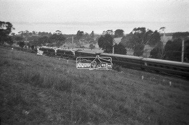
 Eltham District Historical Society Inc
Photograph, George Burton Coop, The Royal Train enroute to Lilydale, near Croydon, 6 Mar. 1954
... and the Dorset Road bridge. Taken late afternnon by George Coop's father... Station and the Dorset Road bridge. Taken late afternnon by George ...Believed to have been taken bewteen Croydon Railway Station and the Dorset Road bridge. Taken late afternnon by George Coop's father. There is a Landrover parked on the grass with a person standing on it - believed to be Security. George recalls originally being located closer to the fence and being ushered up the hill where it was 'safer' to stand. In 1954 at age 27, Queen Elizabeth II was the first reigning British monarch to visit Australia.. She visited Victoria between March 1-10. Where to see the Queen (1954, January 21). Fern Tree Gully and District Times (Boronia, Vic. : 1953-1954), p. 5. Retrieved October 25, 2021, from http://nla.gov.au/nla.news-article264220429 “The Lilydale Shire President, Cr. Burgi, stated that the Royal train en route for Warburton on Saturday, March 6th, would slow down at Croydon and Lilydale. There was little possibility that it would stop at either of these towns. The train would pass through Lilydale at 5.52 p.m. Council had appointed a sub-committee to arrange matters, and had allocated £400 towards expenses. It was suggested that the train slow down between the railway station and Dorset Rd. bridge at Croydon, and between the Cave Hill Quarry and railway station at Lilydale.” An album of images of the Queen's visit to Victoria is available on the PROV Flickr account at https://www.flickr.com/photos/public-record-office-victoria/7252885616Digital TIFF file Scan of Kopdak 620 black and white negative transparencygeorge coop collection, croydon, royal train