Showing 40540 items matching "roads and streets"
-
 Bayside Gallery - Bayside City Council Art & Heritage Collection
Photograph, Department of Crown Lands and Survey, Victoria, Brighton, Brighton East and Bentleigh, c. 1965-71
The Department of Crown Lands and Survey (1857-1983) was responsible for the administration of survey and mapping and the sale, occupation and management of crown land throughout its existence. This aerial photograph shows parts of Brighton and Brighton East and was taken circa 1965-71.brighton, department of crown lands and survey, aerial photograph, bayside, port phillip bay, map, cartographic material, brighton east, dendy park, dendy street, centre road, nepean highway, south road, brighton golf course, golf -
 City of Kingston
Photograph - Black and white, 3 March 1954
Cheltenham and Moorabbin are suburbs within the City of Kingston that were originally established as rural market gardening communities The area is bordered by Highett and Mentone. The market gardens, farms and paddocks have gradually been sub-divided into housing and industrial estates. Highett is developed with residential homes but was also the site of major facilities such as the Highett Gas Works. This aerial image covers a diverse section of the City of Kingston, taking in the suburbs of Moorabbin, Cheltenham, Highett and Mentone Residential housing development is prominent along the Frankston Railway line and the area still retains extensive market gardens and paddocks yet to be converted to a large industrial and commercial zone.Aerial photograph of Mentone, Cheltenham and Moorabbin within the City of Kingston. The area depicted in this 1954 aerial view includes Warrigal Road and Centre Dandenong Road intersection (top left); Charman Road, Patty Street, Bourke Street, Collins Street Mentone (top right); Keys Road Moorabbin (bottom left); Bay Road, Cheltenham (bottom right), Friendship Square, Cheltenham Park, Victoria Golf Club and Jack Barker Oval are visible. Nepean Highway and the Frankston railway line run centrally through the image. Highett Gasworks is also evident.White handwriting and type [indecipherable]. White image of clockface White image of compass White type 42956 Black handwriting 3/3/54 Williams [indecipherable] Black pencil: S [arrow] Black ink: 3/3/1954cheltenham, moorabbin, mentone, highett, market gardens -
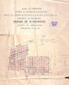 Ringwood and District Historical Society
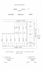
Map - Plan of Subdivision, Crown Allotments 4 and 5, and Parts of Crown Allotments 6, 8 and 9 Section B, Township and Parish of Ringwood, County of Mornington - Salter's Estate East Ringwood Victoria - 1956
Land Title map of 51 allotments with property dimensions and handwritten real estate sales notations. Copy of map on cardboard backing - extracted from auction advertisement for Saturday, 10th November (1956).Subdivision includes Railway Avenue, Nicholson Street, Althol Grove (later Morcom Avenue), Illoura Avenue, Tweed Street, Merry Street, and Dublin Road, Ringwood East, Victoria. -
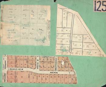 Ringwood and District Historical Society
Card, Collage of Residential Subdivision Map Clippings - Ringwood, Victoria - (Undated)
Three maps mounted on green cardboard - Hand-drawn map of residential allotments off Warrandyte Road in Milne Road and Berringa Road Park Orchards. Map with acres roods and perches measurements of allotments in Canterbury Road and Miller Street Heathmont. Clipping from a land sale brochure with street names not existing together in the area - Rangeview Avenue, Press Avenue and Mountview Avenue. -
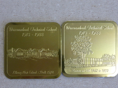 Warrnambool and District Historical Society Inc.
Souvenir - Warrnambool Technical School 1913-1988 souvenir coasters and placemats, 1988
These coasters and placemats are souvenirs of the 75th anniversary of the Warrnambool Technical School. The scenes depicted are Original Timor Street School built 1926, Timor Street with second storey 1967, New School built 1972. Dunkeld Annexe commenced 1975, Library new School built 1972, Annexe on Hill 1962 to 1978. They depict the ongoing development of the school which now operates as Brauer College in Caramut Road Warrnambool. Historical and social. A common item in the 20th century and as one of Warrnambool’s largest and longest running school would have some interest for a large number of local people. The artist John Moir was a local artist.Six White drink coasters with different black and white sketches. Rounded corners edged in black. In olive green box. Set two consists of two gilt metal coasters with engravings. Both are incorrectly labelled. Blue felt on the reverse. The scenes depicted are 000828.1.1 Original Timor Street School built 1926, 000828.1.2 Timor Street with second storey 1967, 000828.1.3 New School built 1972. 000828.1.4 Dunkeld Annexe commenced 1975, 000828.1.5 Library new School built 1972, 000828.1.6 Annexe on Hill 1962 to 1978. They depict the ongoing development of the school which now operates as Brauer College in Caramut Road Warrnambool. The two gilt metal coasters 000828.2.1 Library new School Built 1972 000828.2.2 Annexe on Hill 1962 to 1973 Placemats 000828.3.1 Original Timor Street School built 1926, 000828.3.2 Timor Street with second storey 1967, 000828.3.3 New School built 1972. 000828.3.4 Dunkeld Annexe commenced 1975, 000828.3.5 Library new School built 1972, 000828.3.6 Annexe on Hill 1962 to 1978.All have artist’s signature, John Moir, Warrnambool Technical School 1913-1988. warrnambool, warrnambool technical school, warrnambool annexe, timor street technical school, john moir, warrnambool souvenirs -
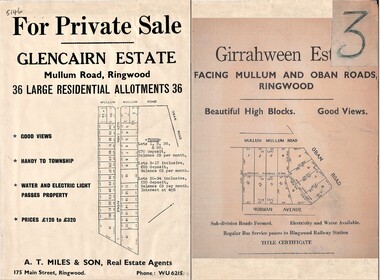 Ringwood and District Historical Society
Document - Folder, Land Sale Advertisement, Glencairn Estate and Girrahween Estate, Ringwood - circa 1950s
Single sided advertisement for private sale of residential allotments - undated, circa 1950s.Subdivisions include Mullum Mullum Road,Glen Cairn Avenue (Glencairn), Oban Road, and Norman Avenue (later Hugh Street). Agent - A.T. Miles & Son, 175 Main Street, Ringwood, Phone WU 6215. -
 Marysville & District Historical Society
Photograph (Item) - Colour photograph, Unknown
A colour photograph of Murchison Street in Marysville in Victoria.A colour photograph of Murchison Street in Marysville in Victoria.murchison street, marysville, victoria, photograph -
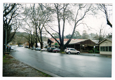 Marysville & District Historical Society
Photograph (Item) - Colour photograph, Unknown
A colour photograph of Murchison Street in Marysville in Victoria.A colour photograph of Murchison Street in Marysville in Victoria.murchison street, marysville, victoria, photograph -
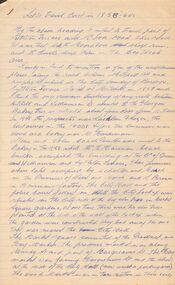 Bendigo Historical Society Inc.
Document - LET'S TRAVEL EAST IN 1858 - 60'S
Nine pages of handwritten account of businesses from Mitchell Street, along Lyttleton Terrace and McIvor Road to the City boundary on the Bendigo side of Murphy Street.document, let's travel east in 1858 - 60's, moorabbee sheep run, curr's sheep run, glasgow bakery, lachlan frazer, mr hardiman, steen and holm coach painters, mr h haisman coach builder, scholton and march, march and s brown, haisman factory, city hall, police court, city lockup, market square, senior citizens club, weighbridge, dunlop tyre service station, tommy burns, matt lynch, tom & mick kennedy, darling hotel, the innes, mr bullens fruit shop, bricklayers arms hotel, cheshire arms hotel, mr i boffey, newcombe's timber yard, quinns monumental establishment, alexandra fountain, cumberland hotel, sannaman's coach factory, town hall hotel, her majesties open air picture show, mr r anderson, john ohagan, sandhurst hotel, the melbourne café, haymarket hotel, the old haymarket hotel, the market ale house, the prince of wales theatre, manchester hotel, mr john doran, dr backhaus, manchester hall, the bendigo star, james griffen coach factory, mr george lansell, whitting's marine store, cartrights marine store, sandhurst flour mills, mr john buckley, moorhead hay and corn mills, brian boru hotel, mr m r?dea, mr worth, mr condon, mr c cahill, nolan family, mr sides, the nailons, mrs boyan, jacky bryant, john oconnell general store, mr pierce, mr matthews, mr neil ward, mr hagan, william clapton, mr joseph dowd, mr morris, ancient briton hotel, the woolpak, the railway bridge, ampol service station, farrells dairy, farringtons brickworks, jacksons hide & tallow yard, fergusons, royal oak hotel, mr jackson, mr knight, st marys common school no812, mrs rersol, w d quinn, mr march, mr fred randall, mr steeple, the limerick hotel, back creek police shooting range, police station, stone lockup, holts service station, steepe's butcher shop, joch, john hattam -
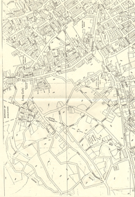 Bendigo Historical Society Inc.
Map - LONG GULLY HISTORY GROUP COLLECTION: MAP OF LONG GULLY AREA
BHS CollectionTwo copies of a map, printed on yellow paper, of the Long Gully Area. It shows Eaglehawk Road from Barnard Street to a little past William Street.bendigo, history, long gully history group, the long gully history group - map of long gully area, victorian water supply reserve, borough of eaglehawk -
 Ringwood and District Historical Society
Document, Auction Flyer - Hill's Estate, Wantirna Road, Ringwood - 1960
Typewritten details of Land Auction, 14th May, 1960, with map showing ten allotments in area bounded by Yarmouth Street, Wantirna Road and Walmer Street. Terms £100 Deposit. Residue £30 qrt including interest 6-1/2% Balance 5 years. (Agents) - A.T. Miles & Son, 175 Whitehorse Road, Ringwood WU.6215. C.E. Carter & Son, 126 Whitehorse Road, Ringwood WU.6024, WU.6830. -
 Ringwood and District Historical Society
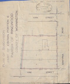
Document - Plan of Subdivision, Part of Crown Portion 6 Parish of Ringwood, County of Mornington - (Undated, circa 1913)
Map attached to blue cardboard backing showing weatherboard house and 3 residential allotments on Wantirna Road between Kirk Street and Vine Street, Ringwood. -
 Whitehorse Historical Society Inc.
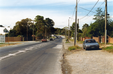
Photograph, Prior to Widening Mitcham Road, 1/02/2000 12:00:00 AM
Coloured photograph of Mitcham Road looking back towards Mitcham. Nursery on left and Mulsanne Street on left. Photo taken before construction to widen Mitcham Road.mitcham road, donvale, mulsanne street -
 Kew Historical Society Inc
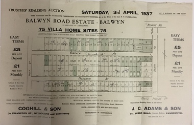
Plan - Subdivision Plan, Balwyn Road Estate, Balwyn (1937), 1937
Historic subdivision in Balwyn, VictoriaSubdivision Plan of Balwyn Road Estate (Balwyn). Held in April 1937, the auction included 102 lots for sale in Yongala Avenue, Young Street, and Balwyn RoadInscriptions on individual lots by agentsubdivision plans - balwyn (vic), balwyn road estate - balwyn -
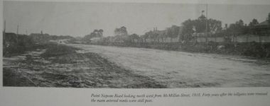 Glen Eira Historical Society
Caulfield Transport
... Roads ...Photograph of Point Nepean Road looking north west from McMillan Street circa 1918caulfield, point nepean road, roads, mcmillan street -
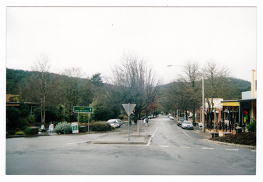
 Marysville & District Historical Society
Photograph (Item) - Colour photograph, Travel Victoria, 2006
A colour photograph of Murchison Street in Marysville in Victoria.A colour photograph of Murchison Street in Marysville in Victoria. Shows the view looking up Pack Road. The buildings that can be seen in the photograph were all destroyed in the 2009 Black Saturday bushfires.murchison street, pack road, marysville, victoria, photograph, 2009 black saturday bushfires -
 Eltham District Historical Society Inc
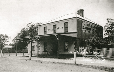
Photograph, On the Melbourne Road; C. Watson's Eltham Hotel and Stables
The 1852 owner was Benjamin O'Wallis who died in 1896Photocopy of a photograph of C. Watson's Eltham Hotel, cnr. Main Road and Pitt Street, Elthamhotels, eltham, c watson, main road, pitt street, benjamin o'wallis -
 Eltham District Historical Society Inc
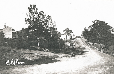
Photograph, Eltham (between Henry and York Streets), 1900s
... Eltham (between Henry and York Streets) ...Photocopy of an original image of Main Road, Eltham, south from Henry Street, early 1900s.main road, henry street, eltham -
 Eltham District Historical Society Inc
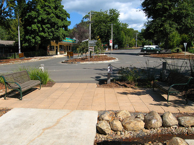
Photograph, Eltham Community Centre
Australia’s first mud brick community building was opened in 1978. In 2018 a major upgrade took place. Colour photograph of mud brick Eltham Community Centre at corner of Main Road and Pitt Streeteltham, community centre, buildings, mud brick, main road, pitt street, eltham community reception centre -
 Ringwood and District Historical Society
Photograph, Methodist Church, Station Street, Ringwood - viewed from clock tower in 1960, 1960
Methodist Church, Station Street, Ringwood, viewed from the clock tower at Warrandyte Road in 1960Written on back of photograph, "Methodist Church from clock tower - 1960". -
Glenelg Shire Council Cultural Collection
Photograph - Photograph - Bridge Construction, n.d
Port of Portland Authority Archivesport of portland archives, tidewater road, otway street bridge -
 Bendigo Historical Society Inc.
Slide - BENDIGO & EASTER FAIR, c1966
Bethlehem Home for the Aged. Corner of Specimen Hill Road and Taylor Street, Golden Square (Bendigo).slide, bendigo, bethlehem home, bethlehem home for the aged -
 Bendigo Historical Society Inc.
Slide - BENDIGO & EASTER FAIR, c1966
Bethlehem Home for the Aged, corner Specimen Hill Road and Taylor street, Golden Square (Bendigo).slide, bendigo, bethlehem, bethlehem home for the aged -
Whitehorse Historical Society Inc.
Article, Clinic vandalised again, 1992
Vandalism is making life difficult for doctors at a Vermont Clinic, corner of Frances Street and Boronia Road.Vandalism is making life difficult for doctors at a Vermont Clinic, corner of Frances Street and Boronia Road.Vandalism is making life difficult for doctors at a Vermont Clinic, corner of Frances Street and Boronia Road.health services, smyth, tom (dr), vandalism -
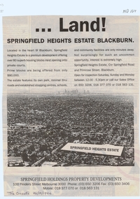 Whitehorse Historical Society Inc.
Document, Land! Springfield Heights Estate, Blackburn, 26/10/1994 12:00:00 AM
Springfield Heights Estate; cnr Springfield Road and Primrose Street, Blackburn.Nunawading Gazette advertisement for Springfield Heights Estate; cnr Springfield Road and Primrose Street, Blackburn.Springfield Heights Estate; cnr Springfield Road and Primrose Street, Blackburn.springfield heights estate, springfield road, blackburn north, primrose street, springfield holdings property developments, residential development -
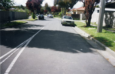 Whitehorse Historical Society Inc.
Photograph, Gibson Street, Mitcham, 1/10/2000 12:00:00 AM
Coloured photograph of Gibson Street Mitcham, off Rooks Road, just south of the railway line.mitcham, gibson street -
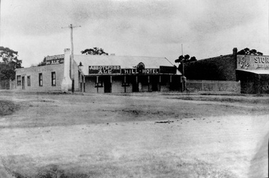 Whitehorse Historical Society Inc.
Photograph, Hill Hotel
Black and white Photo of Hill Hotel, S.W. corner of Station Street and Whitehorse Road, Mitcham.hill hotel, mitcham, o'callaghan's hotel -
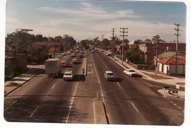 Whitehorse Historical Society Inc.
Photograph - Coloured Photograph, Whitehorse Road Blackburn, 2/08/1979 12:00:00 AM
Coloured photo of Whitehorse Road and Station Street corner, from Blackburn overpass looking Eastwhitehorse road, blackburn -
 Whitehorse Historical Society Inc.
Photograph, Station Street Mitcham
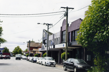
Coloured photograph of the eastern end of Station Street, Mitcham, looking towards Whitehorse Road - 2012station street, mitcham -
 Whitehorse Historical Society Inc.
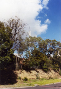
Photograph, Telecom Tower, 2007
Coloured Photo of Telecom Communication Tower near the corner of Egerton Road and Cook Street, Mitcham.telecom communication tower, mitcham, telecom australia