Showing 3383 items
matching run
-
 Melbourne Legacy
Photograph, Fundraising, 1985
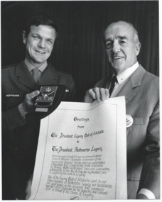
Warrant officer Mike Hoffman ran from Adelaide to Melbourne in 1985 as a fundraiser for Legacy that raised over $5,000. This photo shows him presenting Melbourne Legacy with a letter from Adelaide Legacy. It mentions that the long distance run began in Adelaide on 20 September and reached Melbourne on 27 September. Legatee Larkin was filling in for the president and accepted the letter. WO2 Hoffman had carried the scroll during his marathon run from Adelaide to Melbourne. The photo had been sent to Legacy by Army Public Relations. The photo came from a Legacy envelope marked "P3 Fund Raising" in red pen, with assorted photos of fundraising events, including appeal tins in different years and a charity concert, and a fundraising marathon run (some are items 00433 to 00438, 01410 to 01415).A record of an Army officer doing a long distance run to fundraise for Legacy in 1985.Black and white photo of Warrant Officer Mike Hoffman and a Legatee holding a message from Legacy Club of Adelaide. White paper note typed in black ink ‘MELA 85/199/14 Thanks from the widows and children of Legacy was the message from Legatee Larkin. Legatee Larkin was deputising for the president of Melbourne Legacy when received, from Warrant Officer Class Two Mick Hoffman a scroll bearing greetings from Adelaide Legacy. WO2 Hoffman had carried the scroll during his marathon run from Adelaide to Melbourne in an effort that raised over five thousand dollars for Legacy. Stamped on reverse of photo is an 'Army Public Relations Photo MELA' stamp in black ink and '85/199/14' handwritten in pencil.fundraising, legacy promotion -
 Victorian Harness Racing Heritage Collection at Lord's Raceway Bendigo
Photograph - Framed photo finish, Greg Matthews Photo, Bag Limit, 8 January 1986
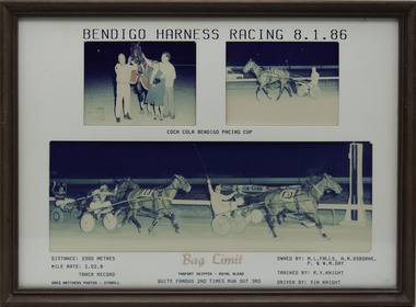
Bag Limit won the Bendigo Pacing Cup on the 8 January 1986, followed by Quite Famous and Times Run Out. Bag Limit owned by ML Falls, AM Osborne, P & WM Day, was trained by RV Knight and driven by Vin Knight. Bag Limit raced from 1985 (3yo) through to 1990 (8yo). Career: 35 wins 16 seconds 5 thirds 71 starts.Three colour photographs, two small one large in a brown frame. At the top: Bendigo Harness Racing 8-1-86/ Coca Cola Bendigo Pacing Cup At the bottom: Left corner: Distance 2300 metres/ Mile rate 2.02.8/ Track Record / Greg Matthews Photos - Stawell Centre: Bag Limit (Tarport Skipper - Royal Blend) / Quite Famous 2nd / Times Run Out 3rd Right corner: Owned by- ML Falls, AM Osborne, P & WM Day/ Trained by RV Knight / Driven by Vin Knightbendigo harness racing club, horses, race, winner, bendigo trotting club, pacing cup, driver, trainer, owner, 1986, bag limit, rv knight, vin knight, ml falls, am osborne, p & wm day, quite famous, times run out, vj knight, bob knight -
 Orbost & District Historical Society
horse leggings, Before 1914
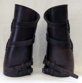
Used by the Light Horse Brigade in WW1. Donated by the family of Fred Christmas.This WW1 item is a reminder of those who took part in that conflict.A pair of dark brown horse leggings. Straps run around outside to a buckle. They are 'Light Horse Brigade" leggings from World War 1.horse-leggings transport ww1 light-horse-brigade -
 Hume City Civic Collection
Photograph
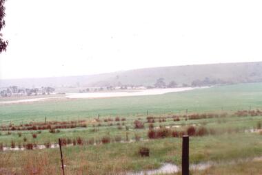
The series of photographs were taken after exceptional heavy rain had fallen in Sunbury in the early 1990s. The Jackson Creek overflowed its banks and the surrounding flood plain area was under water.A coloured photograph of the Jackson Creek in flood along a river flat within the Rupertswood Estate. There are bare hills in the background and a fenced off run in the foreground.floods, weather patterns, jacksons creek, george evans collection -
 Whitehorse Historical Society Inc.
Newspaper - Article, Vintage drivers to see cottage, n.d
'Vintage drivers to see cottage'. Article re vintage drivers finishing a run at Schwerkolt Cottage, also playground equipment to be installed by Lions Club.vintage drivers club, schwerkolt cottage -
 Ballarat Heritage Services
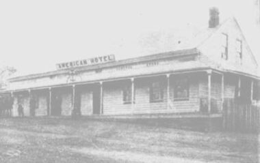
Photograph, American Hotel, Hepburn, 1900, 1900
The American Hotel was destroyed in the Hepburn Bushfire of 1906. A weatherboard hotel in Hepburn run by Robert Righetti. In 1900 Cobb and Co Coaches from Dayelsford left the American Hotel every two hours. daylesford, american hotel, hepburn, robert righetti -
 Bendigo Historical Society Inc.
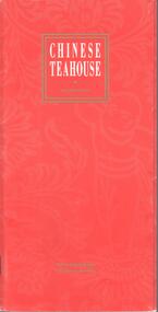
Programme - JOAN O'SHEA COLLECTION: CHINESE TEA HOUSE PROGRAMME
Programme of events held by the Chinese tea house to celebrate ''100 years Loong'' . The events run from April 11th to April 20th, 1992.chinese -
 Whitehorse Historical Society Inc.
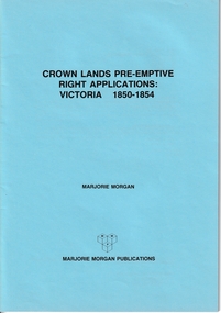
Administrative record - Crown Land Valuations and Applications, Government Printer - John FERRES, Crown Lands Pre-emptive Right Applications: Victoria 1850-1854, 1855
Contains a valuation for Crown Lands applications under pre-emptive right by Victorian county, giving names of applicants name of run, area, and remarks.Contains a valuation for Crown Lands applications under pre-emptive right by Victorian county, giving names of applicants name of run, area, and remarks. Contains a valuation for Crown Lands applications under pre-emptive right by Victorian county, giving names of applicants name of run, area, and remarks. clarke andrew, anglesey, evelyn, bourke, dalhousie, dundas, follett, grant, hampden, heytesbury, normanby, polwarth, ripon, talbot, villiers, district of murray, district of wimmera, district of western port, early settlement, mornington -
 Department of Energy, Environment and Climate Action
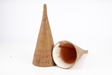
Phoschek viscosity funnels
Athol Hodgson began testing of retardants in 1963 at Ballarat by dropping water thickened with bentonite clay directly from a Ceres CA-28 aircraft. In 1965 dropping a new chemical retardant Phoschek was produced by Monsanto All this experimental work culminated with two Piper Pawnees from Benambra, flown by Ben Buckley and Bob Lansbury, making Australia’s first operational drop of fire-retardant on a small lightning-strike on 6 February 1967. The flight at Benambra came to symbolise the classic application of firebombing and a "proof-of-concept" that encouraged many more innovations with new and more powerful aircraft.Fibreglass funnels used to measure the viscosity of the fire retardant, Phoscheck The funnel was filled with liquid and timed to run through between 35 and 50 secondsforests commission victoria (fcv), bushfire, fire pump, fire tanker -
 Lakes Entrance Historical Society
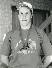
Photograph - Terry Fox Run, Lakes Post Newspaper, 1996
Black and white photograph of Nick Huggins, winner of the Terry Fox Fun Run raising funds for the Anti Cancer Council. Lakes Entrance Victoriafundraising, cancer council -
 Lakes Entrance Historical Society
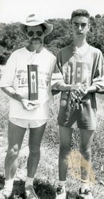
Photograph - Fun Run, Lakes Post Newspaper, 1993
Black and white photograph, Bruce Salisbury and Shannon Hurren, holding their trophies, first and second place winners in the Fun Run. Lakes Entrance Victoriasports, fundraising -
 Wodonga & District Historical Society Inc
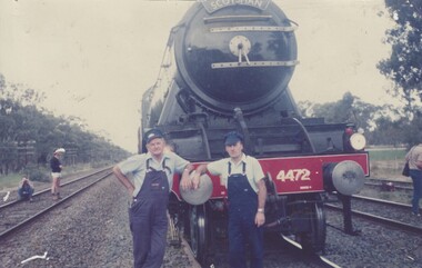
Photograph - Fred Rochow Railways Collection - Driver Len Gregson and Fireman Noel Strauss, 20 October 1988
The Fred Rochow Railways Collection incorporates photos related to the operation of the Wodonga Railway Station including different types of trains and railways staff C. 1930 – 1990. It was donated to the Wodonga Historical Society by Fred Rochow, a railwayman who spent many years based in Wodonga. He joined the Victorian Railways on 17th June l947 and retired in 1988. For some time, he was a member of the Australian Federated Union of Locomotive Enginemen and served a term as a member of the Trades Hall Council. He had an extensive knowledge of the struggles that took place to achieve better conditions for railway workers. Fred worked for many years as a fireman and then worked his way up the ranks to driver, experiencing many changes from the days of steam locomotives through to diesel trains, locomotives and even the modern XPT train. He worked throughout Victoria at different stages of his career, with his final working years focused on the northeast of Victoria and the Albury to Melbourne line. After his retirement, Fred continued to share his love of steam miniature trains with the community.This collection has local and statewide significance as it captures images of trains, locomotives and personnel who operated the railway services in Wodonga and throughout Northeast Victoria. The railways played a critical role in opening up Victoria and connecting Australia for trade, business, social communication and transport.The "Flying Scotsman's" first run in Victoria. This photo was taken at the crew changeover in Longwood after the run from Albury. The Flying Scotsman Pacific 4-6-2, perhaps one of the most iconic steam locomotives in the world, visited Australia in 1988-89 for a series of events associated with the country’s Bicentennial Celebrations. This included the AusSteam 88 Steam Locomotive exhibition in Melbourne. At the top edge of the locomotive "SCOTSMAN" and on the lower edge of the locomotive "4472"railways wodonga, fred rochow, wodonga railwaymen, fireman noel strauss, driver len gregson, the flying scosman -
Glenelg Shire Council Cultural Collection
Photograph - Photograph - aerial view of Portland coast, c. 1954
Black and white aerial photograph of coastline around Portland. Black border, scale all sides, 5 rows of 3 't' at regular intervals. Ocean, land with lakesFront: '820 -8' - handwritten, white, lower border 'RUN 5' 'PORTLAND', printed, white, lower borderaerial photography, central portland, portland harbour, south west coastline -
Glenelg Shire Council Cultural Collection
Photograph - Photograph - aerial view of Portland coastline, c. 1954
Black and white aerial photograph of coastline around Portland. Black border, scale all sides, 5 rows of 3 't' at regular intervals. Buildings visible most areas of photoFront: '607 -107' -- handwritten, white, lower border 'RUN 5' 'PORTLAND', printed, white, lower border -
Glenelg Shire Council Cultural Collection
Photograph - Photograph - aerial view of Portland, c. 1954
Black and white aerial photograph of coastline around Portland. Black border, scale all sides, 5 rows of 3 't' at regular intervals. Ocean at right, land on left.Front: '820 - 7' -- handwritten, white, lower border 'RUN 5' 'PORTLAND', printed, white, lower borderaerial photography, central portland, portland harbour, south west coastline -
Glenelg Shire Council Cultural Collection
Photograph - Photograph - aerial view of Portland, c. 1954
Black and white aerial photograph of coastline around Portland. Black border, scale all sides, 5 rows of 3 't' at regular intervals. Mostly ocean, small area of land lower left.Front: '820-6' -- handwritten, white, lower border 'RUN 5' 'PORTLAND', printed, white, lower borderaerial photography, central portland, portland harbour, south west coastline -
Glenelg Shire Council Cultural Collection
Photograph - Photograph - aerial view of Portland, c. 1954
Black and white aerial photograph of coastline around Portland. Black border, scale all sides, 5 rows of 3 't' at regular intervals.Front: '607 -105' -- handwritten, white, lower border 'RUN 5' 'PORTLAND', printed, white, lower borderaerial photography, central portland, portland harbour -
Glenelg Shire Council Cultural Collection
Photograph - Photograph - aerial view of Portland coastline, 1954
Black and white aerial photo of coastline around Portland. Black border, scale on all sides, 5 rows of 3 't', at regular intervalsFront: '607 -102' -- handwritten, white, lower border 'RUN 5' 'PORTLAND', printed, white, lower borderaerial photography, portland harbour, south west coastline -
Glenelg Shire Council Cultural Collection
Photograph - Photograph - aerial view of Portland, c. 1954
Black and white aerial photograph of coastline around Portland. Black border, scale all sides, 5 rows of 3 't' at regular intervalsFront: '607 -101' - handwritten, white, lower border. 'Run 5' 'PORTLAND'. printed, white lower border.aerial photography, central portland, portland harbour, south west coastline -
Glenelg Shire Council Cultural Collection
Photograph - Photograph - aerial view of Portland, c. 1954
Black and white aerial photograph of coastline around Portland. Black border, scale all sides, 5 rows of 3 't' at regular intervals.Front: '607 -104' - handwritten, white, lower border 'RUN 5' 'PORTLAND', printed, white, lower borderaerial photography, central portland, portland harbour, south west coastline -
Glenelg Shire Council Cultural Collection
Photograph - Photograph - aerial view of Portland, c. 1954
Black and white aerial photograph of coastline around Portland. Black border, scale all sides, 5 rows of 3 't' at regular intervals. Fifty percent ocean, 50 percent land. See 'Other Information'Front: '820 -49' - handwritten, white, lower border 'RUN 6' 'PORTLAND', printed, white, lower borderaerial photography, central portland, portland harbour, south west coastline -
Glenelg Shire Council Cultural Collection
Photograph - Photograph - aerial view of Portland, c. 1954
Black and white aerial photograph of coastline around Portland. Black border, scale all sides, 5 rows of 3 't' at regular intervals.Front: '607 -103' -- handwritten, white, lower border 'RUN 5' 'PORTLAND', printed, white, lower borderaerial photography, central portland, portland harbour, south west coastline -
Glenelg Shire Council Cultural Collection
Photograph - Photograph - aerial view of Portland, c. 1954
Black and white aerial photograph of coastline around Portland. Black border, scale all sides, 5 rows of 3 't' at regular intervals. Buildings visible bottom leftFront: '607 -106' -- handwritten, white, lower border 'RUN 5' 'PORTLAND', printed, white, lower borderaerial photography, central portland, portland harbour, south west coastline -
 St Kilda Historical Society
Photograph - Photo map, 08/02/1966
One of a series of photo-maps produced for the Department of Crown Lands and Survey (1857-1983). For correlation with a current map, and access to other historical photo maps of Victoria, see the Historic Photo-Maps Index published by the Department of Environment, Land, Water and Planning at https://services.land.vic.gov.au/DELWPmaps/historical-photomaps/Black and white aerial photographVic 1916 Melbourne 1966 Project Run 13 E 8.2.66 Lens 122 151.75MM 9.800 113st kilda, st kilda marina, st kilda beach, point ormond, elwood, elwood beach, elwood park, 1966 -
 St Kilda Historical Society
Photograph - Photo map, 08/02/1966
One of a series of photo-maps produced for the Department of Crown Lands and Survey (1857-1983). For correlation with a current map, and access to other historical photo maps of Victoria, see the Historic Photo-Maps Index published by the Department of Environment, Land, Water and Planning at https://services.land.vic.gov.au/DELWPmaps/historical-photomaps/Black and white aerial photographVic 1916 Melbourne 1966 Project Run 13 E 8.2.66 Lens 122 151.75MM 9.800 111st kilda, balaclava, caulfield, caulfield north, st kilda east, elsternwick, elsterwick park, elwood park, elwood canal, elwood beach, ripponlea, 1966 -
 St Kilda Historical Society
Photograph - Photo map, 11/01/1968
One of a series of photo-maps produced for the Department of Crown Lands and Survey (1857-1983). For correlation with a current map, and access to other historical photo maps of Victoria, see the Historic Photo-Maps Index published by the Department of Environment, Land, Water and Planning at https://services.land.vic.gov.au/DELWPmaps/historical-photomaps/Black and white aerial photographVic 2132 State Aerial Survey Melbourne 1968 Proj Run 27E 11.1.68 5100 ASL 65caulfield north, caulfield park, armadale, malvern, 1968 -
 St Kilda Historical Society
Photograph - Photo map, 11/01/1968
One of a series of photo-maps produced for the Department of Crown Lands and Survey (1857-1983). For correlation with a current map, and access to other historical photo maps of Victoria, see the Historic Photo-Maps Index published by the Department of Environment, Land, Water and Planning at https://services.land.vic.gov.au/DELWPmaps/historical-photomaps/Black and white aerial photographVic 2132 State Aerial Survey Melbourne 1968 Proj Run 27E 11.1.68 5100 ASL 67st kilda east, st kilda cemetery, caulfield north, alma park, balaclava, armadale, 1968 -
 St Kilda Historical Society
Photograph - Photo map, 11/01/1968
One of a series of photo-maps produced for the Department of Crown Lands and Survey (1857-1983). For correlation with a current map, and access to other historical photo maps of Victoria, see the Historic Photo-Maps Index published by the Department of Environment, Land, Water and Planning at https://services.land.vic.gov.au/DELWPmaps/historical-photomaps/Black and white aerial photographVic 2132 State Aerial Survey Melbourne 1968 Proj. Run 27E 11.1.68 5100 ASL 69st kilda, albert park, st kilda east, st kilda beach, alma park, windsor, prahran, 1968 -
 St Kilda Historical Society
Photograph - Photo map, 11/01/1968
One of a series of photo-maps produced for the Department of Crown Lands and Survey (1857-1983). For correlation with a current map, and access to other historical photo maps of Victoria, see the Historic Photo-Maps Index published by the Department of Environment, Land, Water and Planning at https://services.land.vic.gov.au/DELWPmaps/historical-photomaps/Black and white aerial photographVic 2132 State Aerial Survey Melbourne 1968 Proj. Run 28E 11.1.68 5100 ASL 81st kilda, balaclava, st kilda east, ripponlea, elwood, elsternwick, caulfield, st kilda botanical gardens, 1968 -
 St Kilda Historical Society
Photograph - Photo map, 11/01/1968
One of a series of photo-maps produced for the Department of Crown Lands and Survey (1857-1983). For correlation with a current map, and access to other historical photo maps of Victoria, see the Historic Photo-Maps Index published by the Department of Environment, Land, Water and Planning at https://services.land.vic.gov.au/DELWPmaps/historical-photomaps/Black and white aerial photographVic 2132 State Aerial Survey Melbourne 1968 Proj. Run 29E 11.1.68 5100 ASL 194elwood, elwood beach, elwood park, elsternwick park, ripponlea, elwood canal, balaclava, st kilda, 1968