Showing 8618 items matching "south road"
-
 Whitehorse Historical Society Inc.
Document, Advance Blackburn
... blackburn road south parade francoms paddock blackburn township ...Copy of letter informing Blackburn residents of Nunawading Shire Council's grant of 75 pounds towards purchasing a block of land to run through from The Avenue to Blackburn Road and requesting donations from local residents.land subdivision, williams, e.g., page, chas. d, elmore, algernon john, shire of nunawading, the avenue, blackburn, blackburn road, south parade, francoms paddock, blackburn township estate, king's subdivision -
 Whitehorse Historical Society Inc.
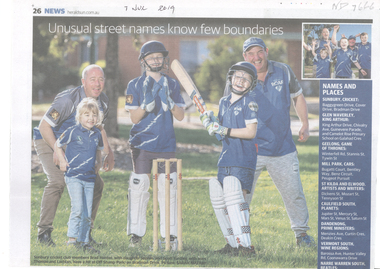
Article, Catchy Addresses, 2019
... Mitcham Barossa Avenue Vermont South Hunter Valley Road Vermont ...Mitcham streets reflecting Indian cities that were named by a well-known local who loved travelling there.Mitcham streets reflecting Indian cities that were named by a well-known local who loved travelling there. Vermont South streets named after Australia's best wine regions was testament to the suburb's wine-making history.Mitcham streets reflecting Indian cities that were named by a well-known local who loved travelling there. agra street, mitcham, calcutta street, mitcham, delhi street, mitcham, barossa avenue, vermont south, hunter valley road, vermont south, coonawarra drive, vermont south -
 Kew Historical Society Inc
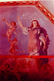
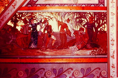
Slide - Ballroom Mural: South Esk (formerly 'Ordsall'), 1980
... south esk -- cotham road -- kew (vic.)... interior decoration south esk -- cotham road -- kew (vic.) ordsall ...One of a group of slides taken by members of the Society of built heritage in Kew in 1979-80. The selection of subject matter reflects the priorities of the period. The colour of some slides has degraded.The slides represent a snapshot in time of built architecture in Kew, much of which has changed in the forty-plus period since they were created. 35mm colour transparency (slide) taken from a photograph of a section of the ballroom ceiling of South Esk (Ordsall). The photo was developed in 1980. There is a high degree of colour distortion in the transparency.victorian architecture, victorian interior decoration, south esk -- cotham road -- kew (vic.), ordsall, murals -
 Kew Historical Society Inc
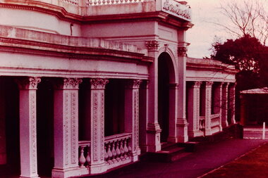
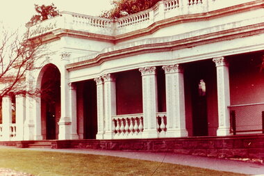
Slide - Facade of South Esk (formerly 'Ordsall'), 1980
... south esk -- cotham road -- kew (vic.)... since they were created. victorian architecture south esk ...One of a group of slides taken by members of the Society of built heritage in Kew in 1979-80. The selection of subject matter reflects the priorities of the period. The colour of some slides has degraded.The slides represent a snapshot in time of built architecture in Kew, much of which has changed in the forty-plus period since they were created. 35mm colour transparency (slide) taken from a photograph of the facade of South Esk (Ordsall). The photo was developed in 1980. There is a high degree of colour distortion in the transparency.victorian architecture, south esk -- cotham road -- kew (vic.), ordsall -
 Kew Historical Society Inc
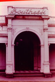
Slide - Portico of South Esk (formerly 'Ordsall'), 1980
... south esk -- cotham road -- kew (vic.)... since they were created. victorian architecture south esk ...One of a group of slides taken by members of the Society of built heritage in Kew in 1979-80. The selection of subject matter reflects the priorities of the period. The colour of some slides has degraded.The slides represent a snapshot in time of built architecture in Kew, much of which has changed in the forty-plus period since they were created. 35mm colour transparency (slide) taken from a photograph of the portico of South Esk (Ordsall). The photo was developed in 1980. There is a high degree of colour distortion in the transparency.victorian architecture, south esk -- cotham road -- kew (vic.), ordsall -
 Kew Historical Society Inc
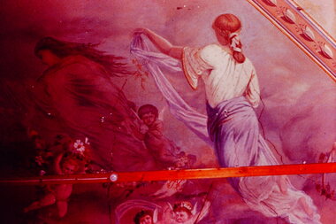
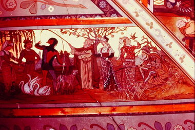
Slide - Section of mural in the Drawing Room of South Esk (formerly 'Ordsall'), 1980
... south esk -- cotham road -- kew (vic.)... since they were created. victorian architecture south esk ...One of a group of slides taken by members of the Society of built heritage in Kew in 1979-80. The selection of subject matter reflects the priorities of the period. The colour of some slides has degraded.The slides represent a snapshot in time of built architecture in Kew, much of which has changed in the forty-plus period since they were created. 35mm colour transparency (slide) taken from a photograph of a section of the mural in the Drawing Room of South Esk (Ordsall). The photo was developed in 1980. There is a high degree of colour distortion in the transparency.victorian architecture, south esk -- cotham road -- kew (vic.), ordsall, murals, victorian interior decoration -
 Kew Historical Society Inc
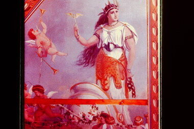
Slide - Section of Mural in the Ballroom of South Esk (formerly 'Ordsall'), 1980
... south esk -- cotham road -- kew (vic.)... since they were created. victorian architecture south esk ...One of a group of slides taken by members of the Society of built heritage in Kew in 1979-80. The selection of subject matter reflects the priorities of the period. The colour of some slides has degraded.The slides represent a snapshot in time of built architecture in Kew, much of which has changed in the forty-plus period since they were created. 35mm colour transparency (slide) taken from a photograph of a section of the mural in the ballroom of South Esk (Ordsall). The photo was developed in 1980. There is a high degree of colour distortion in the transparency.victorian architecture, south esk -- cotham road -- kew (vic.), ordsall, murals, victorian interior decoration -
 Kew Historical Society Inc
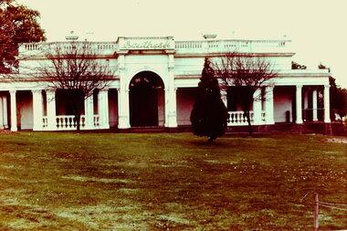
Slide - South Esk (formerly 'Ordsall'), 1980
... south esk -- cotham road -- kew (vic.)... since they were created. victorian architecture south esk ...One of a group of slides taken by members of the Society of built heritage in Kew in 1979-80. The selection of subject matter reflects the priorities of the period. The colour of some slides has degraded.The slides represent a snapshot in time of built architecture in Kew, much of which has changed in the forty-plus period since they were created. 35mm colour transparency (slide) taken from a photograph of South Esk (Ordsall). The photo was developed in 1980. There is a degree of colour distortion in the transparency.victorian architecture, south esk -- cotham road -- kew (vic.), ordsall -
 Kew Historical Society Inc
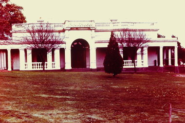
Slide - South Esk (formerly 'Ordsall'), 1980
... south esk -- cotham road -- kew (vic.)... since they were created. victorian architecture south esk ...One of a group of slides taken by members of the Society of built heritage in Kew in 1979-80. The selection of subject matter reflects the priorities of the period. The colour of some slides has degraded.The slides represent a snapshot in time of built architecture in Kew, much of which has changed in the forty-plus period since they were created. 35mm colour transparency (slide) taken from a photograph of South Esk (Ordsall). The photo was developed in 1980. There is a degree of colour distortion in the transparency.victorian architecture, south esk -- cotham road -- kew (vic.), ordsall -
 Kew Historical Society Inc
Slide - South Esk (formerly 'Ordsall'), 1980
... south esk -- cotham road -- kew (vic.)... since they were created. victorian architecture south esk ...One of a group of slides taken by members of the Society of built heritage in Kew in 1979-80. The selection of subject matter reflects the priorities of the period. The colour of some slides has degraded.The slides represent a snapshot in time of built architecture in Kew, much of which has changed in the forty-plus period since they were created. 35mm colour transparency (slide) taken from a photograph of South Esk (Ordsall). The photo was developed in 1980. There is a small amount of colour distortion in the transparency.victorian architecture, south esk -- cotham road -- kew (vic.), ordsall -
 Kew Historical Society Inc
Slide - Section of the mural in the Drawing Room of South Esk (formerly 'Ordsall'), 1980
... south esk -- cotham road -- kew (vic.)... they were created. victorian architecture south esk -- cotham road ...One of a group of slides taken by members of the Society of built heritage in Kew. The selection of subject matter reflects the priorities of the period. The colour of some slides has degraded.The slides represent a snapshot in time of built architecture in Kew, much of which has changed in the forty-plus period since they were created. 35mm colour transparency (slide) taken from a photograph of a section of the drawing room ceiling of South Esk (Ordsall) [demolished 1970]. The photo was developed in 1980. There is a high degree of colour distortion in the transparency.victorian architecture, south esk -- cotham road -- kew (vic.), ordsall, interior decoration - nineteenth century -
 Kew Historical Society Inc
Slide - Section of the mural in the Ballroom of South Esk (formerly 'Ordsall'), 1980
... south esk -- cotham road -- kew (vic.)... they were created. victorian architecture south esk -- cotham road ...One of a group of slides taken by members of the Society of built heritage in Kew. The selection of subject matter reflects the priorities of the period. The colour of some slides has degraded.The slides represent a snapshot in time of built architecture in Kew, much of which has changed in the forty-plus period since they were created. 35mm colour transparency (slide) taken from a photograph of a section of the ballroom ceiling of South Esk (Ordsall) [demolished 1970]. The photo was developed in 1980. There is a high degree of colour distortion in the transparency.victorian architecture, south esk -- cotham road -- kew (vic.), ordsall, interior decoration - nineteenth century -
 Port Fairy Historical Society Museum and Archives
Photograph, Jock Varcoe
... Coloured photograph of Road building on South Beach Estate... Street Port Fairy great-ocean-road South Beach Development south ...South Beach DevelopmentColoured photograph of Road building on South Beach Estatesouth beach, development, road, street, building -
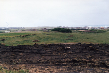
 Port Fairy Historical Society Museum and Archives
Photograph
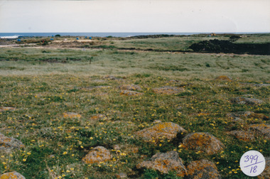
... Street Port Fairy great-ocean-road South Beach Development South ...South Beach DevelopmentColoured photograph of Looking from hill above South Beach Estate before earth workssouth beach, development, south west, bluestone, road, street -
 Port Fairy Historical Society Museum and Archives
Photograph
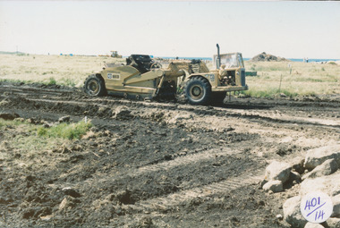
... Street Port Fairy great-ocean-road South Beach Development South ...South Beach Development south beach, development, road, road making, equipment, street -
 Port Fairy Historical Society Museum and Archives
Photograph
... Street Port Fairy great-ocean-road South Beach Developement south ...South Beach Developement south beach, development, road, streets -
 Port Fairy Historical Society Museum and Archives
Photograph
... Street Port Fairy great-ocean-road South Beach Development South ...South Beach Development south beach, development, road making, street, ocean, sea -
 Port Fairy Historical Society Museum and Archives
Photograph
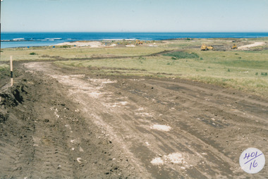
... Street Port Fairy great-ocean-road South Beach Development South ...South Beach Development south beach, development, road, road making -
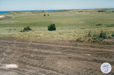
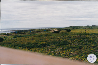 Port Fairy Historical Society Museum and Archives
Photograph
... Street Port Fairy great-ocean-road South Beach Development south ...South Beach Development Coloured photograph of South beach estate, blue marks are tree plantings along track397/10 (since removed 2021)south beach, development, road, road making, estate -
 Port Fairy Historical Society Museum and Archives
Photograph
... Street Port Fairy great-ocean-road South Beach Developement south ...South Beach Developement Coloured photograph of Earthworks in foreground with a tree shelter belt in middle distance and South Beach Estate in distancesouth beach, development, road making, street -
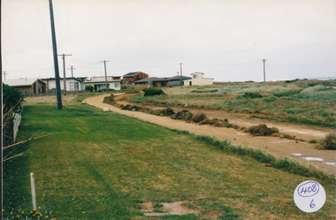 Port Fairy Historical Society Museum and Archives
Photograph
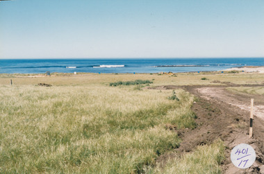
... Street Port Fairy great-ocean-road South Beach Development south ...South Beach Development Coloured photograph of Ocean Drive being graded and widened408/6 since been removed (2021)south beach, development, road making, ocean drive -
 Flagstaff Hill Maritime Museum and Village
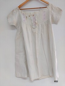
Clothing - Chemise, Eliza Towns, Late Victorian era
... Maritime Museum and Village Warrnambool Great Ocean Road south west ...This chemise is one of several linen and clothing items that were made and belonged to Mrs. Eliza Towns and donated to Flagstaff Hill Maritime Museum and Village. Eliza was born Eliza Gould in 1857 in South Melbourne (Emerald Hill) and in 1879 married Charles Towns. In the early 1880's they moved to Nhill in western Victoria and remained there for the rest of their married life. Charles was a jeweller and later became an accountant and for many years was involved with the Shire Council, the local show committee (A & P Society), the Hospital Committee and the Board of the local newspaper (the Nhill Free Press). They had three children and lived a life that would be regarded as comfortably "middle class". Eliza probably had a treadle sewing machine and would have made many of her own clothes as well as clothes for her children - adding her own handmade embroidered or crocheted decorative trim. This chemise is machine sewn by Eliza Towns and she has added pintucks and broderie anglaise lace as a decorative element. A chemise was usually a sleeveless garment made of linen or cotton (so they could be easily washed) and its shape was much like a modern day nightgown. The name comes from the French word for "shirt" or "shift". Women wore chemises next to the skin (under the corset) to keep stains and odors away from the less washable corset and gown.This item is an example of the needlework skills of women in the mid to late 19th century - combining machine stitching with hand embroidery to personlise and embellish an item of clothing. It is also significant as an example of a practical solution to the difficulties of needing to regularly hand wash a bulky outer garment or gown in the Victorian era.A white cotton, short sleeved, knee length chemise. The fabric at the front is gathered on a yoke which is decorated with bands of five pintucks alternating with broderie anglaise lace and embroidered strips lined with pink ribbon. A different broderie anglaise design decorates the sleeve edges, neckline and center broderie anglaise strip. The back of the chemise is gathered on to the neckline. There are two bands of pintucks on each sleeve. The fabric around each armhole has been strengthened with another layer of cotton and a length of cotton has been added (from the left shoulder to the hem) to increase the width of chemise.flagstaff hill, flagstaff hill maritime museum and village, warrnambool, great ocean road, south west victoria, victorian era, victorian era undergarments, chemise, victorian era chemise, undergarments, pintucks, victorian chemise, eliza towns, nhill, wimmera, home sewing, machine sewn, hand made -
Whitehorse Historical Society Inc.
Map, Springvale Road, 1968
... Highway, south past Highbury Road.... photograph of cnr Springvale Road and Burwood Highway, south past ...Aerial photograph of cnr Springvale Road and Burwood Highway, south past Highbury Road.Aerial photograph of cnr Springvale Road and Burwood Highway, south past Highbury Road.Aerial photograph of cnr Springvale Road and Burwood Highway, south past Highbury Road.aerial photographs, highbury road, burwood east, burwood highway, burwood east, springvale road, burwood east -
 Whitehorse Historical Society Inc.
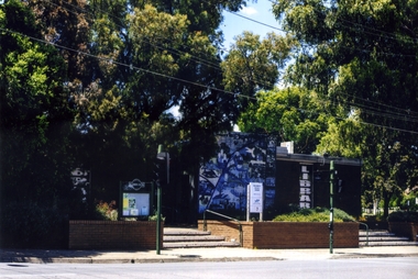
Photograph, Blackburn Library, 2012
... side of Blackburn Road. South Parade is opposite... of the Blackburn Library on the eastern side of Blackburn Road. South ...Coloured photograph of the Blackburn Library on the eastern side of Blackburn Road. South Parade is oppositeblackburn branch library -
 Whitehorse Historical Society Inc.
Pamphlet, Artist's Camp, 1987
... was made on David Houston's property on Gardiners Creek, south... property on Gardiners Creek, south of Canterbury Road, between..., south of Canterbury Road, between the present sites of Bowater ...Pamphlet on Box Hill Artists CampPamphlet on Box Hill Artists Camp and the move to Eaglemont, near Heidelberg when the term Heidelberg School began to be used, in 1988. The Box Hill Camp was made on David Houston's property on Gardiners Creek, south of Canterbury Road, between the present sites of Bowater Scott and Box Hill Golf Club.Pamphlet on Box Hill Artists Camp artists camps, roberts, tom, mccubbin, frederick, streeton, arthur, conder, charles, abrahams, louis, houston, david, gardiners creek -
 Whitehorse Historical Society Inc.
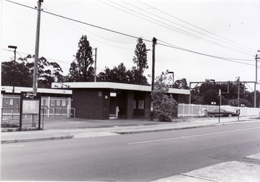
Photograph, Blackburn Railway Station, 6/01/2001 12:00:00 AM
... looking south from Railway Road, Blackburn....Whitehorse Historical Society Inc. 2-10 Deep Creek Road ...Black and white photograph of Blackburn Railway Station looking south from Railway Road, Blackburn.blackburn railway station. -
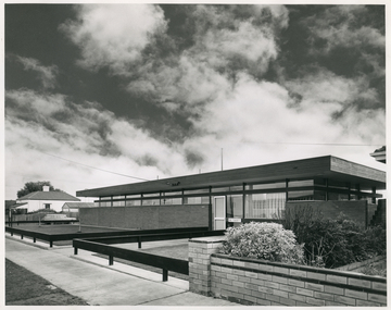 Royal District Nursing Service (now known as Bolton Clarke)
Photograph - Photograph, black and white, 30 06 1965
... Nursing Service (MDNS) Moorabbin Centre, situated at 611 South... (MDNS) Moorabbin Centre, situated at 611 South Road, Moorabbin ...This photograph is a record of the Melbourne District Nursing Service (MDNS) Moorabbin Centre, situated at 611 South Road, Moorabbin. It was opened in mid 1965 and was the fourth Centre MDNS had opened. Following Royal patronage in 1966, it became known as Royal District Nursing Service (RDNS) Moorabbin Centre.Gradually over the years, Melbourne District Nursing Service, MDNS, later known as Royal District Nursing Service, RDNS, from 1966 when they received Royal patronage, opened Centres throughout the Melbourne Metropolitan area. Their Trained nurses (Sisters) left from these Centres each morning to carry out their nursing visits in a specific area, taking any sterilized equipment needed with them. They returned at the end of the day to write up their patients nursing histories, clean and reset any equipment used ready for sterilization, and to contact other medical personal as necessary. Most of the RDNS cars were housed at each Centre, only a few being driven home by a Sister.Black and white photograph of RDNS Moorabbin Centre. The building is a single story brick building with a flat roof. A row of short glass windows are seen above the brick work to the left of the large glass doors which are on the right of the building. A low standing horizontal fence is seen along the front and along either side of the path leading up to the door. Some bushes are seen in the right hand side garden of the building. A footpath can be seen in front of the fence. On the left of the photograph can be seen a white house with a pitched roof. A dark sky with fluffy white 'cumulus' clouds are seen above the buildings.Photographers stamp. Quote No. DX 18mdns, melbourne district nursing service, mdns centres, royal district nursing service, rdns -
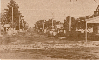 Whitehorse Historical Society Inc.
Postcard, Blackburn Road Blackburn
... looking South from Railway Road 1918. Reproduced from 'Blackburn... of Postcards of Blackburn Road looking South from Railway Road 1918 ...2 Black and white copies of Postcards of Blackburn Road looking South from Railway Road 1918. Reproduced from 'Blackburn A Picturesque History' by Robin Da Costa, Pioneer Design Studio P/L, Lilydale.blackburn road, blackburn -
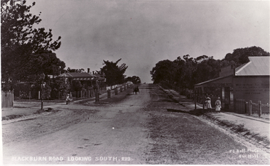 Whitehorse Historical Society Inc.
Photograph, Blackburn Road
... Black and white photo of Blackburn Road, looking South... of Blackburn Road, looking South (captioned). Blackburn Road Photograph ...Black and white photo of Blackburn Road, looking South (captioned).blackburn road, blackburn