Showing 664 items
matching state issue
-
 Athletics Victoria
Blazer, Pocket, VAAA Pocket
VAAA blazers were issued and worn by athletes and officials representing the state of Victoria at athletic meets at home & interstate. This VAAA pocket has been cut from a club blazer.The have the honour of being presented with a VAAA blazer is high recognition of an athlete's ability and acknowledgement of their achievements at the highest level of competition.A dark blue serge cloth Victorian Amateur Athletics Association blazer pocketVAAA logo depicting a flaming Olympic Torch inside a large white "V"above the letters A.A. A.sport, athletics, track & field, apparel, uniforms, blazers -
 Ballarat Tramway Museum
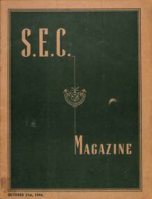
Magazine, State Electricity Commission of Victoria (SECV), SEC Magazine, 31/10/1944
Magazine published by the State Electricity Commission of Victorian reporting the success of the Ballarat, Bendigo and Geelong entrants in the Most Popular Conductress Competition with photographs of each of the Conductresses and their fundraising totals. Sylvia Mitchell Ballarat, Miss J McCurdy Geelong, and Mrs. D Rosewarne Bendigo. See item 8825 for part of this magazine collected by Sylvia Mitchell. See also item 247 for another image. Included in this issue are items on casualties on service, briquette factory notes, how street lights affect trees, unique transformer at Newport, Sergeant Staples and Mrs Mitchell, Australia's First Electric tram (Doncaster - Box Hill), Kiewa notes, G A Laurens on Bendigo, American Hospitality, In and around Yallourn, Rabual, How to become Magician C J White, Mozart by Wim Platt, the meaning of Maru, On Active Service, and letters from Servicemen.Demonstrates the SECV news reporting to employees and the general public during the Second World War.Magazine - 48 quarto pages + light card covers, coloured cover centre stapled.tramways, ballarat, bendigo, most popular conductress competition, sylvia mitchell, secv, doncaster, second world war, geelong -
Ballarat Tramway Museum
Document - Report, State Electricity Commission of Victoria (SECV), "Creation of a state electricity Commission"
Report titled "Creation of a State Electricity Commission", and "History of Provincial tramways before Act No. 3845 - 1929". Outlines the context of the SEC Act of 1919 which did not include tramway operation by the power or electricity supply authority - was seen as a Municipal concern. Gives the alternatives that were considered, including the agreement with the Municipal Councils of Geelong, Ballarat, and Bendigo. Notes the operation of urban omnibus services and the issues of the lack of municipal supervision, though later on this occurred through the Transport Regulation Board.Yields information about the operation of the Provincial tramways under the control of the SECV.Five foolscap sheets, carbon copycouncils, secv, buses, ballarat, bendigo, geelong, trb -
Ballarat Tramway Museum
Document - Report, State Electricity Commission of Victoria (SECV), "Description of the Provincial Tramways when taken over"
Document - full title - Provincial Tramways - "Description of the Provincial Tramways when taken over by the State Electricity Commission" looks at the condition of the Ballarat and Bendigo systems at the time compared to that of Geelong. The handwritten note records the impact of the closure of the gold mines in the two cities. Records that Bendigo received more investment in track and tramcars than did Ballarat. Includes notes on the condition of the track, issues with tramcars and insulation of the tramcars at the time, and the purchase of second-hand tramcars from Melbourne.Yields information about the operation of the Provincial tramways before the takeover by the SECV.Two foolscap sheets, carbon copyHas an ink addition in the top left hand corner.secv, ballarat, bendigo, geelong, mesco, esco, tramways, tramcars, operations -
 Bendigo Historical Society Inc.
Document - State of Victoria - Country Party
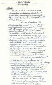
... State of Victoria Country Party This handwritten letter is part ...This handwritten letter is part of the Aileen and John Ellison collection. Possibly written by John in the 1970's. Under the title "State of Victoria Country Party - Objectives" is a collection of thoughts and idea on current issuesstate of victoria, country party -
 Ballarat Tramway Museum
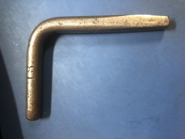
Functional object - Tramcar door square key, State Electricity Commission of Victoria - Ballarat office, Mid 1930's?
Used by tram crews to secure doors in the open or closed position and to open the used ticket box. Part of the items issued to each traffic crew or maintenance staff to access or lock tramcars.Would have been issued at the time to a driver or conductor with the cap or traffic number of 18Piece of chrome plated steel rod bent at 90 degrees and shaped at longer end to give a square shape for use in external doors on SECV Ballarat Trams - known as a square key. Was used to secure doors in both open and closed positions. Has been stamped 18 on one side at short end.18ballarat, tramcars, equipment, crews, doors, tramways -
 Ballarat Tramway Museum
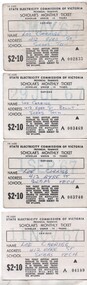
Ephemera - Scholar's Monthly ticket - Ballarat, State Electricity Commission of Victoria (SECV), 1966
Scholar's monthly ticket for use by under 15 years students. Has form number "TYE 3-570" in top left hand corner. Space for an expiry date to be stamped on the ticket and name, address and school of the student. The 1966 Schedule of Fares and Charges shows these tickets. See Reg Item 6870 for samples of unused tickets. All issued to the donor Lee Carrigg. Also issued in Bendigo. Yields information and demonstrates the tickets used to for Scholar's or students to travel on the trams in Ballarat during the mid 1960's. Shows the approx numbers of tickets issued each month.Set of four Yellow cloth backed paper tickets with white front, printed in black ink with fare value of $2.10. Ticket Nos 002833, 3469, 3740, 4189.Have been stamped with the month and year of issue and all written with the name of the person and their address.ballarat, schools tickets, scholars tickets, tickets, tramways, trams -
 Ballarat Tramway Museum
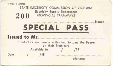
Ephemera - "Special Pass", State Electricity Commission of Victoria (SECV), 1950s
Issued to employees such as shed staff and other office staff. See also 3648 for an early example of this type of pass and Reg Item, 8126 for an example of use by Wayne Kell.Demonstrates the method that the SECV used to enable free travel for employees and staff.Set of 3 passes or Tickets - White card (200 gsm) ticket with, printed in black ink - titled "Special Pass". Form number "TYE 2-220" in top left hand corner. Has space for the name of the Bearer (issued to Mr. ...), Branch to be written, space for manager to sign with date .../.../19.... and expiry date of pass." Conditions of use printed on rear. 1 - Has number "200" stamped on. 2 - 172 3 - 165 sec tramways, ballarat, tickets, provincial cities, special pass, employees -
 Ballarat Tramway Museum
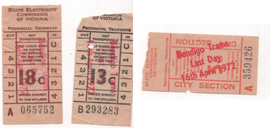
Ephemera - Tickets - over stamped "Bendigo Trams 16th April 1972", State Electricity Commission of Victoria (SECV)
Issued by conductors on the last day of SECV tram services in Bendigo to mark the occasion. Demonstrates the work the local office of the SECV did to mark the occasion. Three SECV paper tickets - 13c (black) No. B293283, 18c (brown) No. A065752 and 5c City Section A359426 over stamped in red "Bendigo Trams 16h April 1972". Has the SEC logo of the time of a child wrapped in a blanket on the rear.bendigo, tramways, secv tramways, last day, closure, tickets, overstamped, secv -
 Ballarat Tramway Museum
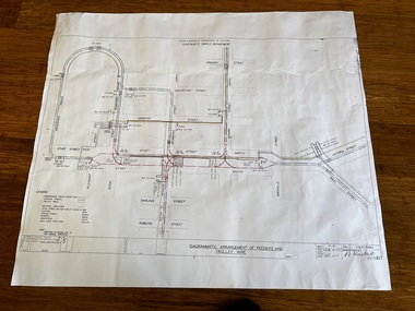
Drawing - VB4/7184C, State Electricity Commission of Victoria - Ballarat office, "Diagrammatic Arrangement of Feeders and Trolley Wire", 2-9-1958
Print of drawing number VB4/7184C "Diagrammatic Arrangement of Feeders and Trolley Wire", marked up in colour showing the various feeder and trolley wire arrangements for the central part of Ballarat and the Gardens line. Shows the detailed switch locations that enable the overhead to be isolated or changed when electrical work was being undertaken on the overhead that required it to be isolated. Shows how the various sections were fed from the power station. Revision C issued 2-9-1958.Yields information about the arrangement of the power supply to the trams from the power station and changes made to the system about 13 years prior to closure. Dyeline print on white paper of Drawing - "Diagrammatic Arrangement of Feeders and Trolley Wire" - VB4/7184Ctramways, ballarat, secv, trolley wire, feeder cables, overhead, power station, electrical engineering, electrical switching -
 Ballarat Tramway Museum
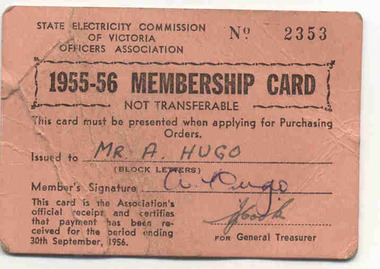
Ephemera, State Electricity Commission of Victoria (SECV), "1955-56 Membership Card", "1958-59 Membership Card", 1955
70 - Cardboard (250 gsm), orange membership card for the State Electricity Commission of Victoria, Officers Association, for 1955 - 56, issued to Mr. A. Hugo. Card No. 2353. Signed by A. Hugo and J. Cook for General Treasurer. For period ending 30/9/1956. 70.1 - ditto, issued for 1958 - 59, blue card, No. 1404, issued to Arthur Hugo, N. McArthur for General Treasurer"Mr. A. Hugo", "J. Cook"trams, tramways, unions, sec, officers, ballarat -
 Ballarat Tramway Museum
Newspaper, The Courier Ballarat, The Courier, Christmas Number, 1922, Special Issue, Dec. 1922
Yields information about Ballarat, it businesses, identifies and its locations or environs through photos and advertisements and articles.The body of the "Christmas Number of the Ballarat Courier, Special Edition - December 1922" = coves missing. See attached listing with worksheet for summary of contents. Contains many advertisement for local business houses, photos and fiction and articles , pages 3 - 94 still existing, stapled. Notes on contents of Christmas Number of The Ballarat Courier Special edition, December 19, 1922. Photos Ballarat Association Cricket Team, winners Country championship - 1922 and photo of dinner at Sth Melb. Town Hall by VCA. - p83 Ballarat Golf club, Arch of Victoria and Club House - p63, 65 Ballarat Imperial Football club - league premier- 1922 - p19 Ballarat Miners Turf Club - showing stands and office bearers - p43 Ballarat North Golf Club - p67 Ballarat Town hall - p87 Ballarat Turf Club Office bearers and race finish - p45 Ballarat Yacht club - opening day and yacht race - p89 Black Hill Progress Association, - members and scenes - p33 Eureka Monument - p79 Finish of a race at Miners RC - p45 Head of the Lake and St. Patrick's the winning crew - p47 1.ake Wendouree - boating on (Gardens side - p] 1 Lake Wendouree, rowing and club houses - p28 Lal Lal waterfalls - p61 Lydiard St. View - Railway Station, Cemetery gates, Mining Exchange, Post Office and Banks - p71 National Federation Conference - 1922 - p39 South city Football club, Ballarat Assoc. Premiers 1922 - p25 Sturt and Lydiard St - top photo Town Hall and T&G building, with ESCo tram (pencil note "Tram No- 3 - Peckham Truck" written in - p75. Bottom photo, looking south from Town Hall. The Western Oval during a football match - p23 Victorian Farmers Union Conference, Ballarat 1922 - p37 Victorian Railway photos of various scenes around Victoria: Pages 3, 5, 7, 55, 59 Views of Victoria Park - p91 VR Ballarat Railway Workshops - p9 Advertisements on even numbered pages, featuring in particular: Ballarat Motor Garage - with photos - p88 C.A.V. Willard - storage battery service Stn - p76 with photo. CA Mitaxa - Builder - includes photos of new homes - p38 Coles & Pullham - stock sales - with photos - p86 ESCo - p70 Geo E. Dibble, machinery merchant - includes photos - p26 Geo. Waller - asphalt and carrier - photos of work and buildings Hanrahan's of Ballarat - Garage and stables - p30 J.L.Ridings - dentists, - photos of surgery p14 Longhurst's Bakeries - Mair and Yuille St. Includes Photos. - P84 Preston Motors, Melbourne - The Maxwell Sep Morse - Motor and Carriage builders - photo - p78 St. Patrick's College - photos of students and buildings - p46 State Savings Bank of Vic. - p20 T-J. Brown house remover and general carrier, photo of traction engines - p90 T.J.Haymes - Wallpaper etc. - p33 The Ballarat Co-Op Distribution Society - includes photos - p44 The Hupmobile - McLean Richards Motors - p22 Wallace Butter Factor - p82 Articles Black Hill Progress Association - p35 Damaged pages - cut outs clippings etc. Page 17/18 - top half bottom 1/3 of page 21/22 Pages: 9, 70, 71, 75, 87 and 90 imaged. Record reviewed and images of some of the pages added 10-9-2013p74. Note re tram 33.trams, tramways, ballarat, commerce, ballarat business, sports, science, esco -
 Ballarat Tramway Museum
Newspaper, The Courier Ballarat, Courier, 8/3/1938 p21, 22, 29 & 30 - photo of Sturt St, Mar. 1938
Yields information about Ballarat and its locations or environs late 1938.Pages 21,22,29 and 30 of the Centenary issue of the Ballarat Courier, 8/3/1938. Page 21 "When the World was Wide", photos, Ballaarat City Council of Centenary of settlement in the Ballarat district, year, and Sturt St. from Bridge St., possibly original photo of time. Ads. - Marks & Phillips, - Tailors and C.J.Coles. Page 22 - Towns that have a history - Learmonth, Clunes, Creswick and Buninyong. Photos - Learmonth, Clunes and Forestry school Creswick. Ads - State Savings Bank of Vic, Swanston Used Cars. Page 29 - Ballarat's historic Sports Grounds - origin and development, Eastern Oval incident, listing of nuggets found and quartz specimens. Ads for Prestige stockings, T&G Mutual Life and Fosters Lager. Photo of mine at No. 6 shaft on Band of Hope and Albion Consolidated. Page 30 - articles - Ballarat's sporting origins and swamp to reservoir (water supply). Photos of First England Cricket team to visit Ballarat and aqueduct at Kirks storage basin. Ads for Craig Bros, Pratts cash stores, Haymes paints and Ballarat Block Arcade - shops. Record reviewed and images of some of the pages added 10-9-2013trams, tramways, ballarat centenary celebrations, centenary, sports ground, water supply -
 Ballarat Tramway Museum
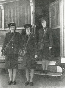
Photograph - Black & White Photograph/s - set of 3, State Electricity Commission of Victoria (SECV), 1942
Yields information about the group of conductresses who were trained in 1942 to release their husbands for the war effort, shows them in uniform with bags.239 - Reproduction of a 1942 photograph that appeared in the Christmas New Year issue of SEC News, (1942-43), p13 showing Ballarat's tram Conductresses, traffic clerks standing in front of SECV tram 29, - laminated with 4 Velcro dots on rear. Copy negative of another copy held by Museum. 239.1 - unlaminated copy of same photograph - added 6/8/2002. Copy 2 - ex Alan Bradley's collection of photographs added 31/7/2007. 293.2 - mounted print on black cardboard with adhesive marks on rear. Both Copy 2 or 2391.1 and 239.2 ex Alan Bradley 5/2007. trams, tramways, ballarat trams, secv, conductresses, world war ii , tram 29 -
 Ballarat Tramway Museum
Photograph - Black & White Photograph/s, State Electricity Commission of Victoria (SECV), Oct. 1944
Demonstrates an important part of Ballarat's tramway operations during the Second World War when Conductresses and many women were employed by the SEC.243 - Photograph reproduction of an illustration that appeared in Oct. 1944 issue of SEC News, p11 of the SEC float in procession to raise funds for the Red Cross - laminated with 4 Velcro dots on rear. 243.1 - unlaminated copy of same photograph - added 6/8/2002. Hi Res scan added 25/3/2011. See p11 of Oct. 1944 SEC Newstrams, tramways, secv, ballarat, world war ii, fund raising, conductresses -
 Ballarat Tramway Museum
Photograph - Black & White Photograph/s, State Electricity Commission of Victoria (SECV), Sept. 1942
Demonstrates an important part of Ballarat's tramway operations during the Second World War when Conductresses and many women were employed by the SEC.Photographic reproduction of an illustration that appeared in the Sept. 1942 issue of SEC News, p6. Photo is of Ballarat's first 3 conductresses - E.Jakobi, J.Wightwick, and C.Browne. Laminated with 4 Velcro dots on rear. John Phillips from a State Library negative of the illustration in Sept. 1995. Hi Res scan added 25/3/2011 See p6 of Sept 1942 issue of SECV News.trams, tramways, secv, ballarat, conductresses, world war ii -
 Ballarat Tramway Museum
Photograph - Black & White Photograph/s, Sept. 1942
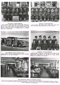
Demonstrates an important part of Ballarat's tramway operations during the Second World War when Conductresses and many women were employed by the SEC.Photographic reproduction of page 13 of Christmas - New Year issue (1942-43) issue of SEC News, from a negative supplied by State Library on photo paper, laminated with 4 Velcro dots on rear. Has photo of conductresses at Geelong, Bendigo and Ballarat, car drivers and clerks at Flinders St. Gives names of conductresses and motor car drivers. Images files 246i1 - full page - small version 246i1a - full page 1200 dpi version - has to be opened in a separate viewed. 246i2 - Ballarat Conductresses 246i3 - Geelong - Geelong Conductresses 246i4 - Car Drivers (Motor Transport - HO) 246i5 - Bendigo Conductresses 246i6& i7 - Flinders St. clerical workers. trams, tramways, secv, world war i, ballarat, bendigo, geelong, conductresses -
 Ballarat Tramway Museum
Document - SEC Instruction Sheet, State Electricity Commission of Victoria (SECV), Special order to Motormen, 49/1, Jul. 1961
Significant in being a detailed set of instructions for parking trams, hand overs, relief, responsibility for the security of the tram, including leaving the tram unattended. Regrettable incidents have happened. Issued 1961. Reg item 3459 has a more detailed set of instructions.Single foolscap sheet titled "Special Order to Motormen (49/1)" giving instructions regarding 1) Responsibility (for trams), 2) Relief on the road, 3) Controller key, 4) Air brake handle, 5) leaving tram unattended. Dated 20 July 1961. Printed from wax stencil. See Reg Item 3459 for 25-1-1965 issue and 5371 for an undated issue. Image of item added 20/10/2013.trams, tramways, ballarat, trams, secv, instructions, operations, braking -
 Ballarat Tramway Museum
Document - Instruction, State Electricity Commission of Victoria (SECV), "Tramcar Emergency Braking", Jul. 1961
Significant in being a detailed set of instructions for the tramcar braking system, emergency braking, what to do if things went wrong. Relates to the driver training system at the time. An earlier version to that of Reg item 271.Two foolscap sheets duplicated giving instructions for emergency braking of tramcars for Ballarat. Gives description of system, the various means of what to do if the system fails - dated 20 July 1961. See Reg Item 3457 for a later issue, 3520 for a 1950 instruction on the same issue, and 5370 for an undated version. Image of document added 22/10/2013.trams, tramways, ballarat, secv instructions, braking, operations -
 Ballarat Tramway Museum
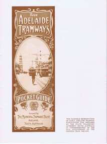
Book, State Transport Authority - SA, "The Adelaide Tramways", Nov. 1979
Facsimile reproduction of an early Adelaide Tramways publication and part of June 13 1918 issue of Tramway & Railway World (London), article on Adelaide's tramways. 20 pages, printed on glossy paper, brown ink, sepia with many photos. Produced for the 50th anniversary of the Glenelg tram - 1979. Image of cover added 2/11/13, item updated for damage. See Gives sources on rear page.trams, tramways, adelaide, mtt, sta -
 Kew Historical Society Inc
Plan, Melbourne & Metropolitan Board of Works : Borough of Kew : Detail Plan No.1576, 1904
The Melbourne and Metropolitan Board of Works (MMBW) plans were produced from the 1890s to the 1950s. They were crucial to the design and development of Melbourne's sewerage and drainage system. The plans, at a scale of 40 feet to 1 inch (1:480), provide a detailed historical record of Melbourne streetscapes and environmental features. Each plan covers one or two street blocks (roughly six streets), showing details of buildings, including garden layouts and ownership boundaries, and features such as laneways, drains, bridges, parks, municipal boundaries and other prominent landmarks as they existed at the time each plan was produced. (Source: State Library of Victoria)This plan forms part of a large group of MMBW plans and maps that was donated to the Society by the Mr Poulter, City Engineer of the City of Kew in 1989. Within this collection, thirty-five hand-coloured plans, backed with linen, are of statewide significance as they include annotations that provide details of construction materials used in buildings in the first decade of the 20th century as well as additional information about land ownership and usage. The copies in the Public Record Office Victoria and the State Library of Victoria are monochrome versions which do not denote building materials so that the maps in this collection are invaluable and unique tools for researchers and heritage consultants. A number of the plans are not held in the collection of the State Library of Victoria so they have the additional attribute of rarity.Original survey plan, issued by the MMBW to a contractor with responsibility for constructing sewers in the area identified on the plan within the Borough of Kew. The plan was at some stage hand-coloured, possibly by the contractor, but more likely by officers working in the Engineering Department of the Borough and later Town, then City of Kew. The hand-coloured sections of buildings on the plan were used to denote masonry or brick constructions (pink), weatherboard constructions (yellow), and public buildings (grey). Development in the 20th century has irreparably altered that part of Kew represented in this plan. In the block bounded by Cotham Road, Charles Street, Wellington Street and Gellibrand; just one house standing in 1903 remains. This block included two of the most historic houses in Kew: ‘Ordsall’ (later ‘Southesk’) and ‘Madford’ (previously ‘Elm Lodge’). Ordsall was the home of the second chairman of Kew, John Halfey. It contained some of the most significant interior murals in Kew, created for Halfey by artists working for Cullen & Co. It was demolished in 1960 to make way for the Kew Civic Centre. Elm Lodge had been built for William Siddeley in ca. 1864. Arthur Septimus King purchased it in 1874. The lower paddocks of Madford were sold in 1905 by his wife to the Borough of Kew and, after landscaping by George and Thomas Pockett, opened as the Alexandra Gardens in 1908. Elm Lodge/Madford was in 1922 to become St. Anthony’s Home for Little Children before its subsequent demolition in the 1980s.melbourne and metropolitan board of works, detail plans, maps - borough of kew, mmbw 1576, cartography -
 Kew Historical Society Inc
Plan, Borough of Kew Detail Plan No.1577, 1904
The Melbourne and Metropolitan Board of Works (MMBW) plans were produced from the 1890s to the 1950s. They were crucial to the design and development of Melbourne's sewerage and drainage system. The plans, at a scale of 40 feet to 1 inch (1:480), provide a detailed historical record of Melbourne streetscapes and environmental features. Each plan covers one or two street blocks (roughly six streets), showing details of buildings, including garden layouts and ownership boundaries, and features such as laneways, drains, bridges, parks, municipal boundaries and other prominent landmarks as they existed at the time each plan was produced. (Source: State Library of Victoria)This plan forms part of a large group of MMBW plans and maps that was donated to the Society by the Mr Poulter, City Engineer of the City of Kew in 1989. Within this collection, thirty-five hand-coloured plans, backed with linen, are of statewide significance as they include annotations that provide details of construction materials used in buildings in the first decade of the 20th century as well as additional information about land ownership and usage. The copies in the Public Record Office Victoria and the State Library of Victoria are monochrome versions which do not denote building materials so that the maps in this collection are invaluable and unique tools for researchers and heritage consultants. A number of the plans are not held in the collection of the State Library of Victoria so they have the additional attribute of rarity.Original survey plan, issued by the MMBW to a contractor with responsibility for constructing sewers in the area identified on the plan within the Borough of Kew. The plan was at some stage hand-coloured, possibly by the contractor, but more likely by officers working in the Engineering Department of the Borough and later Town, then City of Kew. The hand-coloured sections of buildings on the plan were used to denote masonry or brick constructions (pink), weatherboard constructions (yellow), and public buildings (grey). MMBW Plan No.1577 includes some of the most significant houses in Kew: Herbert Henty’s ‘Roxeth’ (now part of Trinity Grammar), ‘Butleigh Wooton’, ‘Bokara’ and ‘Harrow’. It also includes the streets that have since changed their names. That part of College Parade linked to Glenferrie Road is now named College Place, College Parade now extends further north, and Charles Street did not yet reach Barkers Road. Roxeth is one of a number of Henty houses in Kew. Herbert Henty made his home here and was elected a member of Kew Municipal Council in 1864 and mayor in 1868-69. Walter Henry Serle, of Harrow served in the First World War. He was awarded the Military Medal ‘’For conspicuous bravery and devotion to duty. On 29th September near BELLICOURT he showed the greatest bravery and determination when his platoon was attacked by enemy bombing parties. It was due largely to his personal efforts that all the attacks were repulsed. Until wounded, his utter disregard of personal safety and boldness in dealing with the attacks were the means of saving the situation and were an inspiring example to his men.’melbourne and metropolitan board of works, detail plans, maps - borough of kew, mmbw 1577, cartography -
 Kew Historical Society Inc
Plan, Melbourne & Metropolitan Board of Works : Borough of Kew : Detail Plan No.1578, 1904
The Melbourne and Metropolitan Board of Works (MMBW) plans were produced from the 1890s to the 1950s. They were crucial to the design and development of Melbourne's sewerage and drainage system. The plans, at a scale of 40 feet to 1 inch (1:480), provide a detailed historical record of Melbourne streetscapes and environmental features. Each plan covers one or two street blocks (roughly six streets), showing details of buildings, including garden layouts and ownership boundaries, and features such as laneways, drains, bridges, parks, municipal boundaries and other prominent landmarks as they existed at the time each plan was produced. (Source: State Library of Victoria). This plan forms part of a large group of MMBW plans and maps that was donated to the Society by the Mr Poulter, City Engineer of the City of Kew in 1989. Within this collection, thirty-five hand-coloured plans, backed with linen, are of statewide significance as they include annotations that provide details of construction materials used in buildings in the first decade of the 20th century as well as additional information about land ownership and usage. The copies in the Public Record Office Victoria and the State Library of Victoria are monochrome versions which do not denote building materials so that the maps in this collection are invaluable and unique tools for researchers and heritage consultants. A number of the plans are not held in the collection of the State Library of Victoria so they have the additional attribute of rarity.Original survey plan, issued by the MMBW to a contractor with responsibility for constructing sewers in the area identified on the plan within the Borough of Kew. The plan was at some stage hand-coloured, possibly by the contractor, but more likely by officers working in the Engineering Department of the Borough and later Town, then City of Kew. The hand-coloured sections of buildings on the plan were used to denote masonry or brick constructions (pink), weatherboard constructions (yellow), and public buildings (grey). MMBW Plan No.1578 is significant in that it defines the extent of two private schools: Xavier College and Kew High School (now part of Trinity Grammar) by 1904. In relation to the latter, the plan clarifies which buildings the High School operated from behind the mansion ‘Molina’. Established in 1902, Trinity Grammar was to later lease and subsequently buy Molina (now ‘Merritt House’) and ‘Elsinore’ (now ‘Roberts House’). Xavier College had been established in 1872. This 1904 plan delineates the West Wing and the Great Hall (built in 1890).melbourne and metropolitan board of works, detail plans, maps - borough of kew, mmbw 1578, cartography -
 Kew Historical Society Inc
Plan, Melbourne & Metropolitan Board of Works. Borough of Kew Detail Plan No.1579, 1904
The Melbourne and Metropolitan Board of Works (MMBW) plans were produced from the 1890s to the 1950s. They were crucial to the design and development of Melbourne's sewerage and drainage system. The plans, at a scale of 40 feet to 1 inch (1:480), provide a detailed historical record of Melbourne streetscapes and environmental features. Each plan covers one or two street blocks (roughly six streets), showing details of buildings, including garden layouts and ownership boundaries, and features such as laneways, drains, bridges, parks, municipal boundaries and other prominent landmarks as they existed at the time each plan was produced. (Source: State Library of Victoria). This plan forms part of a large group of MMBW plans and maps that was donated to the Society by the Mr Poulter, City Engineer of the City of Kew in 1989. Within this collection, thirty-five hand-coloured plans, backed with linen, are of statewide significance as they include annotations that provide details of construction materials used in buildings in the first decade of the 20th century as well as additional information about land ownership and usage. The copies in the Public Record Office Victoria and the State Library of Victoria are monochrome versions which do not denote building materials so that the maps in this collection are invaluable and unique tools for researchers and heritage consultants. A number of the plans are not held in the collection of the State Library of Victoria so they have the additional attribute of rarity.Original survey plan, issued by the MMBW to a contractor with responsibility for constructing sewers in the area identified on the plan within the Borough of Kew. The plan was at some stage hand-coloured, possibly by the contractor, but more likely by officers working in the Engineering Department of the Borough and later Town, then City of Kew. The hand-coloured sections of buildings on the plan were used to denote masonry or brick constructions (pink), weatherboard constructions (yellow), and public buildings (grey). While MMBW Plan No.1579 does not include many buildings, those that it does show are significant to Kew’s history. These include the ‘Kew [Railway] Station’ in Denmark Street and the ‘Recreation Hall’ and rear courts off Wellington Street. The plan shows the outline of the Recreation Hall, constructed in 1880, at the rear of which is listed a bowling green, two tennis courts, a ‘skittle alley’ and a pavilion. When the Hall was first built, the Kew Cricket Club occupied an adjacent ground, however in 1885 this was acquired by the State Government as the future location of the Kew Railway Station. The Plan also shows a single oval at Xavier College. This oval was completed in 1883. One of the current ovals conforms to this oval’s original shape and position in the school grounds.melbourne and metropolitan board of works, detail plans, maps - borough of kew, mmbw 1579, cartography -
 Kew Historical Society Inc
Plan, Melbourne and Metropolitan Board of Works, Borough of Kew : Detail Plan No.1580, 1904
The Melbourne and Metropolitan Board of Works (MMBW) plans were produced from the 1890s to the 1950s. They were crucial to the design and development of Melbourne's sewerage and drainage system. The plans, at a scale of 40 feet to 1 inch (1:480), provide a detailed historical record of Melbourne streetscapes and environmental features. Each plan covers one or two street blocks (roughly six streets), showing details of buildings, including garden layouts and ownership boundaries, and features such as laneways, drains, bridges, parks, municipal boundaries and other prominent landmarks as they existed at the time each plan was produced. (Source: State Library of Victoria)This plan forms part of a large group of MMBW plans and maps that was donated to the Society by the Mr Poulter, City Engineer of the City of Kew in 1989. Within this collection, thirty-five hand-coloured plans, backed with linen, are of statewide significance as they include annotations that provide details of construction materials used in buildings in the first decade of the 20th century as well as additional information about land ownership and usage. The copies in the Public Record Office Victoria and the State Library of Victoria are monochrome versions which do not denote building materials so that the maps in this collection are invaluable and unique tools for researchers and heritage consultants. A number of the plans are not held in the collection of the State Library of Victoria so they have the additional attribute of rarity.Original survey plan, issued by the MMBW to a contractor with responsibility for constructing sewers in the area identified on the plan within the Borough of Kew. The plan was at some stage hand-coloured, possibly by the contractor, but more likely by officers working in the Engineering Department of the Borough and later Town, then City of Kew. The hand-coloured sections of buildings on the plan were used to denote masonry or brick constructions (pink), weatherboard constructions (yellow), and public buildings (grey). The area represented in this detail plan has undergone significant change during the 20th century. The widening of High Street in the 1930s and 1950s involved the shops on the south side of High Street being demolished and later rebuilt to fit the widened street. Another significant loss was the mansion ‘Drayton’ fronting Wellington Street, owned at this stage by Susannah Fenton. Her family name would later to be given to Fenton Way, which was to be built over the grounds of the house following its demolition. The plan of the garden is particularly interesting, containing a batten dome fronting Wellington Street, an ornamental pond, a fountain and a brick and glass conservatory. The notes by the plumbing contractor on this plan are particularly detailed. Pink borders delineate the ownership of the varying parcels of land. Some of the better known owners listed include the real estate agent Cr. Henry de Castres Kellett (bt) and John Padbury, the funeral director. This particular plan provides a clear view of the configuration of the Kew Junction in 1903 and the commercial buildings that surrounded it.melbourne and metropolitan board of works, detail plans, maps - borough of kew, mmbw 1580, cartography -
 Kew Historical Society Inc
Plan, Melbourne & Metropolitan Board of Works : Borough of Kew : Detail Plan No.1581, 1904
The Melbourne and Metropolitan Board of Works (MMBW) plans were produced from the 1890s to the 1950s. They were crucial to the design and development of Melbourne's sewerage and drainage system. The plans, at a scale of 40 feet to 1 inch (1:480), provide a detailed historical record of Melbourne streetscapes and environmental features. Each plan covers one or two street blocks (roughly six streets), showing details of buildings, including garden layouts and ownership boundaries, and features such as laneways, drains, bridges, parks, municipal boundaries and other prominent landmarks as they existed at the time each plan was produced. (Source: State Library of Victoria)This plan forms part of a large group of MMBW plans and maps that was donated to the Society by the Mr Poulter, City Engineer of the City of Kew in 1989. Within this collection, thirty-five hand-coloured plans, backed with linen, are of statewide significance as they include annotations that provide details of construction materials used in buildings in the first decade of the 20th century as well as additional information about land ownership and usage. The copies in the Public Record Office Victoria and the State Library of Victoria are monochrome versions which do not denote building materials so that the maps in this collection are invaluable and unique tools for researchers and heritage consultants. A number of the plans are not held in the collection of the State Library of Victoria so they have the additional attribute of rarity.Original survey plan, issued by the MMBW to a contractor with responsibility for constructing sewers in the area identified on the plan within the Borough of Kew. The plan was at some stage hand-coloured, possibly by the contractor, but more likely by officers working in the Engineering Department of the Borough and later Town, then City of Kew. The hand-coloured sections of buildings on the plan were used to denote masonry or brick constructions (pink), weatherboard constructions (yellow), and public buildings (grey). The streets and built structures in this plan were surveyed in 1903 and released to contractors in 1904. In addition to the designation of building types by colour, the plan includes detailed descriptions of land use and ownership. While many buildings remain from this period, a number of the buildings represented have been demolished including the original Kew Town Hall, and the Congregational and Roman Catholic churches in Walpole Street. While the mansion ‘Illapa’ in Princess Street is still extant – now part of ‘Rylands’ – the neighbouring mansion ‘Elsmere’ was demolished some decades ago. Rivalling Illapa and Elsmere in size were two mansions in Walpole Street, one named on the plan as ‘Gnarlbine’. Over time, Kew Junction and the south side of High Street have been reconfigured and widened, so that the commercial buildings on the corner of Princess and High Street no longer exist. A surprising feature of this part of central Kew to the northwest of Kew Junction is the amount of vacant land. In a number of cases, this land is noted by the contractor as used for vegetable gardens.melbourne and metropolitan board of works, detail plans, maps - borough of kew, mmbw 1581, cartography -
 Kew Historical Society Inc
Plan, Melbourne & Metropolitan Board of Works : Borough of Kew : Detail Plan No.1582, 1904
The Melbourne and Metropolitan Board of Works (MMBW) plans were produced from the 1890s to the 1950s. They were crucial to the design and development of Melbourne's sewerage and drainage system. The plans, at a scale of 40 feet to 1 inch (1:480), provide a detailed historical record of Melbourne streetscapes and environmental features. Each plan covers one or two street blocks (roughly six streets), showing details of buildings, including garden layouts and ownership boundaries, and features such as laneways, drains, bridges, parks, municipal boundaries and other prominent landmarks as they existed at the time each plan was produced. (Source: State Library of Victoria)This plan forms part of a large group of MMBW plans and maps that was donated to the Society by the Mr Poulter, City Engineer of the City of Kew in 1989. Within this collection, thirty-five hand-coloured plans, backed with linen, are of statewide significance as they include annotations that provide details of construction materials used in buildings in the first decade of the 20th century as well as additional information about land ownership and usage. The copies in the Public Record Office Victoria and the State Library of Victoria are monochrome versions which do not denote building materials so that the maps in this collection are invaluable and unique tools for researchers and heritage consultants. A number of the plans are not held in the collection of the State Library of Victoria so they have the additional attribute of rarity.Original survey plan, issued by the MMBW to a contractor with responsibility for constructing sewers in the area identified on the plan within the Borough of Kew. The plan was at some stage hand-coloured, possibly by the contractor, but more likely by officers working in the Engineering Department of the Borough and later Town, then City of Kew. The hand-coloured sections of buildings on the plan were used to denote masonry or brick constructions (pink), weatherboard constructions (yellow), and public buildings (grey). Public buildings, coloured grey on the Plan 1582 include the police station and post office, churches and schools. The earliest church school, Common School No.356 was located at the rear of the Congregational Church in Peel Street. It was constructed in 1859. The first buildings of Kew Primary School No.1075 on the other side of Peel Street were constructed in 1871. The school in 1903 only occupied a small fraction of its current site. In 1903, where the rear playground is now located, were two weatherboard and one brick villa. Trinity Grammar School was founded in 1902 and opened in the Parish Hall at the rear of Holy Trinity Anglican Church. It was not to move to its current site until 1906. The outline of the building housing the Kew Fire Brigade in the centre of the north side of Walton Street is shown but not named on the plan. Further down Pakington Street stood the two-storey Italianate mansion ‘Overton’. The home of Stanford Chapman, it was to be featured in the Imperial Institute series of bromide photographs of Victoria, Vol. 1: Homes and scenery. It was later to become a boarding house before it was later demolished.melbourne and metropolitan board of works, detail plans, maps - borough of kew, mmbw 1582, cartography -
 Kew Historical Society Inc
Plan, Melbourne & Metropolitan Board of Works : Borough of Kew : Detail Plan No.1585, 1904
The Melbourne and Metropolitan Board of Works (MMBW) plans were produced from the 1890s to the 1950s. They were crucial to the design and development of Melbourne's sewerage and drainage system. The plans, at a scale of 40 feet to 1 inch (1:480), provide a detailed historical record of Melbourne streetscapes and environmental features. Each plan covers one or two street blocks (roughly six streets), showing details of buildings, including garden layouts and ownership boundaries, and features such as laneways, drains, bridges, parks, municipal boundaries and other prominent landmarks as they existed at the time each plan was produced. (Source: State Library of Victoria)This plan forms part of a large group of MMBW plans and maps that was donated to the Society by the Mr Poulter, City Engineer of the City of Kew in 1989. Within this collection, thirty-five hand-coloured plans, backed with linen, are of statewide significance as they include annotations that provide details of construction materials used in buildings in the first decade of the 20th century as well as additional information about land ownership and usage. The copies in the Public Record Office Victoria and the State Library of Victoria are monochrome versions which do not denote building materials so that the maps in this collection are invaluable and unique tools for researchers and heritage consultants. A number of the plans are not held in the collection of the State Library of Victoria so they have the additional attribute of rarity.Original survey plan, issued by the MMBW to a contractor with responsibility for constructing sewers in the area identified on the plan within the Borough of Kew. The plan was at some stage hand-coloured, possibly by the contractor, but more likely by officers working in the Engineering Department of the Borough and later Town, then City of Kew. The hand-coloured sections of buildings on the plan were used to denote masonry or brick constructions (pink), weatherboard constructions (yellow), and public buildings (grey). This plan, which covers parts of High Street, Pakington Street and Derby Street is dominated by two historic Kew mansions: ‘Konetta’ and ‘Ramornie’. Ramornie was constructed in 1890 for James Maitland Campbell, three times Mayor of Kew. Sold in 1940, it became a boarding house known as ‘The Towers’. Now a private residence again, it has only one of its three balconies remaining. The location of the missing two balconies can be seen on the plan. In 1903, the grounds of Ramornie included a large tennis court fronting Pakington Street. The rear of the property is shown as extending to Cobden Street. One of Kew’s oldest hotels, the Prospect Hill Hotel on the corner of High and Cobden Street was established in 1858. The outline of the hotel shown on the plan represents the second building on the site. During the 19th century it was often used for electoral meetings. The Prospect Hill Hotel was to be redeveloped again in 1928, by the local architect Robert McIntyre. Since the 1980s, the hotel has been a live music venue, the home of the Melbourne Jazz Club, a restaurant and a liquor outlet.melbourne and metropolitan board of works, detail plans, maps - borough of kew, mmbw 1585, cartography -
 Kew Historical Society Inc
Plan, Melbourne & Metropolitan Board of Works : Borough of Kew : Detail Plan No.1588, 1904
The Melbourne and Metropolitan Board of Works (MMBW) plans were produced from the 1890s to the 1950s. They were crucial to the design and development of Melbourne's sewerage and drainage system. The plans, at a scale of 40 feet to 1 inch (1:480), provide a detailed historical record of Melbourne streetscapes and environmental features. Each plan covers one or two street blocks (roughly six streets), showing details of buildings, including garden layouts and ownership boundaries, and features such as laneways, drains, bridges, parks, municipal boundaries and other prominent landmarks as they existed at the time each plan was produced. (Source: State Library of Victoria)This plan forms part of a large group of MMBW plans and maps that was donated to the Society by the Mr Poulter, City Engineer of the City of Kew in 1989. Within this collection, thirty-five hand-coloured plans, backed with linen, are of statewide significance as they include annotations that provide details of construction materials used in buildings in the first decade of the 20th century as well as additional information about land ownership and usage. The copies in the Public Record Office Victoria and the State Library of Victoria are monochrome versions which do not denote building materials so that the maps in this collection are invaluable and unique tools for researchers and heritage consultants. A number of the plans are not held in the collection of the State Library of Victoria so they have the additional attribute of rarity.Original survey plan, issued by the MMBW to a contractor with responsibility for constructing sewers in the area identified on the plan within the Borough of Kew. The plan was at some stage hand-coloured, possibly by the contractor, but more likely by officers working in the Engineering Department of the Borough and later Town, then City of Kew. The hand-coloured sections of buildings on the plan were used to denote masonry or brick constructions (pink), weatherboard constructions (yellow), and public buildings (grey). This plan shows the original configuration of the Kew Post Office, Court House and Police Station, which had opened in 1888. This configuration was to essentially remain until the purchase of the Court House and Police Station by the City of Boroondara in 2007 and its subsequent renovation. Interestingly, the MMBW surveyors incorrectly labelled parts of the complex. In the triangle in front of the Post Office, before the erection of the Kew Cenotaph in 1925, was located a lawn and the Queen Victoria Jubilee Fountain. While many of the shops on the south side of High street had been constructed by 1903 a number of sites were still used as vegetable gardens. Further along High Street, on the corner of Charles Street, the Salvation Army Barracks can be seen on the plan. These Barracks predate the later Citadel and ‘Young People’s Hall’ that were opened in 1919. At 22 Charles Street can be seen the house of James Venn Morgan. Hailed as the ‘father of Kew’, Morgan arrived in Melbourne in 1840. He was first engaged as a bookmaker, but a fortunate venture on the goldfields enabled him to purchase land in Kew. He conducted a market garden and dairy in Kew for many years.melbourne and metropolitan board of works, detail plans, maps - borough of kew, mmbw 1588, cartography -
 Kew Historical Society Inc
Plan, Melbourne & Metropolitan Board of Works : Borough of Kew : Detail Plan No.1590, 1905
The Melbourne and Metropolitan Board of Works (MMBW) plans were produced from the 1890s to the 1950s. They were crucial to the design and development of Melbourne's sewerage and drainage system. The plans, at a scale of 40 feet to 1 inch (1:480), provide a detailed historical record of Melbourne streetscapes and environmental features. Each plan covers one or two street blocks (roughly six streets), showing details of buildings, including garden layouts and ownership boundaries, and features such as laneways, drains, bridges, parks, municipal boundaries and other prominent landmarks as they existed at the time each plan was produced. (Source: State Library of Victoria)This plan forms part of a large group of MMBW plans and maps that was donated to the Society by the Mr Poulter, City Engineer of the City of Kew in 1989. Within this collection, thirty-five hand-coloured plans, backed with linen, are of statewide significance as they include annotations that provide details of construction materials used in buildings in the first decade of the 20th century as well as additional information about land ownership and usage. The copies in the Public Record Office Victoria and the State Library of Victoria are monochrome versions which do not denote building materials so that the maps in this collection are invaluable and unique tools for researchers and heritage consultants. A number of the plans are not held in the collection of the State Library of Victoria so they have the additional attribute of rarity.Original survey plan, issued by the MMBW to a contractor with responsibility for constructing sewers in the area identified on the plan within the Borough of Kew. The plan was at some stage hand-coloured, possibly by the contractor, but more likely by officers working in the Engineering Department of the Borough and later Town, then City of Kew. The hand-coloured sections of buildings on the plan were used to denote masonry or brick constructions (pink), weatherboard constructions (yellow), and public buildings (grey). Surveyed by the Board of Works in 1903 and published in 1904, Plan No.1590 shows development north of Cotham Road. While this plan includes built structures in Mary Street, Cotham Road, High Street, Park Hill Road, Kent Street, Ridgeway Avenue, and Ermington Lane (now Ermington Place), only part of this section was notated and coloured in this contractor’s copy. Numerous houses, large and small are named on the plan: ‘Cholula’, ‘Belper’, ‘The Uplands’, ‘Spring Grove’ facing Cotham Road; ‘Marion’ facing Kent Street; and ‘Kia Ora’ facing Ridgeway Avenue.melbourne and metropolitan board of works, detail plans, mmbw 1590, survey plans - borough of kew, cartography