Showing 495 items
matching tree line
-
 Whitehorse Historical Society Inc.
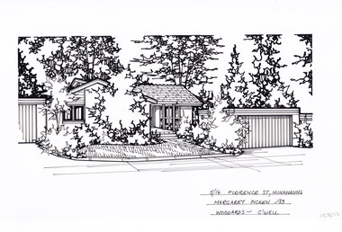
Artwork, other - Ink Line Drawing, Margaret Picken, 5/16 Florence St., Nunawading, 1993
A property illustration by Margret Picken Commissioned by a real estate agency for the purpose of advertising 5/16 Florence St., Nunawading Made by using Rotring ‘Rapidigraph’ drafting pens with Rotring ink on Rapidigraph polyester drafting film, double matte. Trained as a cartographic draftsman within the mining industry, Margaret Picken is an artist who worked producing property illustrations for real estate agencies in eastern suburbs of Victoria from 1983-2005. Retiring from the industry as technological changes favored coloured photography over illustrations, and commissioning companies over sole contractors.This artwork is of Historical Significance as a record of local domestic architecture.A black ink line drawing on drafters film by Margaret Picken, of a black and white line drawing of a single story brick house with a path leading to the front door, from the public footpath. To the right is the separate garage. Trees and shrubs grow in garden beds in front of the buildings and in the background, while in front of the house is a front lawn. There are two holepunch holes centred just under the upper edge.5/16 Florence St., Nunawading Margaret Picken - 93 Woodards - C'wellwhitehorse historical society, schwerkolt cottage, housing, architecture, margaret picken, house, garden, real estate, nunawading -
 Whitehorse Historical Society Inc.
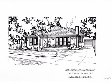
Artwork, other - Ink Line Drawing, Margaret Picken, 39 Kett St., Nunawading, 1993
A property illustration by Margret Picken Commissioned by a real estate agency for the purpose of advertising 39 Kett St., Nunawading. This property is listed as having sold for $137,500 in 1994 Made by using Rotring ‘Rapidigraph’ drafting pens with Rotring ink on Rapidigraph polyester drafting film, double matte. Trained as a cartographic draftsman within the mining industry, Margaret Picken is an artist who worked producing property illustrations for real estate agencies in eastern suburbs of Victoria from 1983-2005. Retiring from the industry as technological changes favored coloured photography over illustrations, and commissioning companies over sole contractors.This artwork is of Historical Significance as a record of local domestic architecture.A black ink line drawing on drafters film by Margaret Picken, of a single story brick house with a driveway on the right leading to a separate garage in the background. in the foreground is a low brick fence enclosing a front yard with garden beds and central tree. There are two holepunch holes on just under the upper edge.39 Kett St., Nunawading Margaret Picken - 93 Woodards - B'Burnwhitehorse historical society, schwerkolt cottage, housing, architecture, margaret picken, house, garden, real estate, nunawading -
 Whitehorse Historical Society Inc.
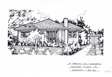
Artwork, other - Ink Line Drawing, Margaret Picken, 14 Mardion Dve., Nunawading, 1991
A property illustration by Margret Picken Commissioned by a real estate agency for the purpose of advertising 3 Lynne St., Nunawading. This property is listed as having sold for $118,000 in 1991 Made by using Rotring ‘Rapidigraph’ drafting pens with Rotring ink on Rapidigraph polyester drafting film, double matte. Trained as a cartographic draftsman within the mining industry, Margaret Picken is an artist who worked producing property illustrations for real estate agencies in eastern suburbs of Victoria from 1983-2005. Retiring from the industry as technological changes favored coloured photography over illustrations, and commissioning companies over sole contractors.This artwork is of Historical Significance as a record of local domestic architecture.A black ink line drawing on drafters film by Margaret Picken, of a black and white line drawing of a single story weatherboard house, with a driveway on the right leading to a separate garage in the background. In the foreground is a front garden, with garden beds and central tree. There are two holepunch holes on just under the upper edge.14 Mardion Dve., Nunawading Margaret Picken - 91 Woodards - Boxhillwhitehorse historical society, schwerkolt cottage, housing, architecture, margaret picken, house, garden, real estate, nunawading -
 Whitehorse Historical Society Inc.
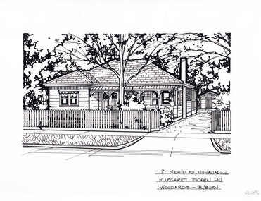
Artwork, other - Ink Line Drawing, Margaret Picken, 8 Menin Dve., Nunawading, 1997
A property illustration by Margret Picken Commissioned by a real estate agency for the purpose of advertising 3 Lynne St., Nunawading. This property is listed as having sold for $225,000 in 1997 Made by using Rotring ‘Rapidigraph’ drafting pens with Rotring ink on Rapidigraph polyester drafting film, double matte. Trained as a cartographic draftsman within the mining industry, Margaret Picken is an artist who worked producing property illustrations for real estate agencies in eastern suburbs of Victoria from 1983-2005. Retiring from the industry as technological changes favored coloured photography over illustrations, and commissioning companies over sole contractors.This artwork is of Historical Significance as a record of local domestic architecture.A black ink line drawing on drafters film by Margaret Picken, of a black and white line drawing of a single story weatherboard house with bullnose verandah covering the front porch. On the right is a driveway leading to a separate garage in the background. In the foreground is a picket fence enclosing the front garden. black and white line drawing of a single story weatherboard house, with a driveway on the right leading to a separate garage in the background. In the foreground is a front garden, with garden beds and central tree. There are two holepunch holes on just under the upper edge.8 Menin Dve., Nunawading Margaret Picken - 97 Woodards - B/Burnwhitehorse historical society, schwerkolt cottage, housing, architecture, margaret picken, house, garden, real estate, nunawading -
 Ballarat Heritage Services
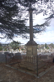
Photograph - Photograph - Colour, Burke and Wills Memorial at Bendigo Cemetery, 2018, 02/09/2018
Robert O'Hara Burke and Thomas Pope Besnard were childhood friends. As sexton of the local Back Creek Cemetery Thomas Besnard organised a subscription to raise the money for a monument to Burke, Wills and Gray. A subscription of one shilling, no more and not less, was asked so all subscribers were equal. The Bendigo monument was designed by Adam Duncan and features a Corinthian column mounted on a foundation stone, topped with a Grecian urn draped with the Union Jack. The stone for the monument was quarried from New Chum Mine. The site in the Bendigo Cemetery was selected by Besnard so the monument was on a grass knoll well clear of any other graves. The design included landscaping with a path and garden beds that provided dignified access. The Burke and Wills Monument in Bendigo has been entered on the Register of the National Estate as being important for its association with historical events and developments associated with exploration in the early days of Colony of Victoria. Two conifers remain from the original group sent by Mueller of the Melbourne Botanical Gardens to develop the garden layout on the knoll. These two trees are listed as Significant Trees by City of Greater Bendigo. The foundation block was laid on 20 August 1862 by Chairman of the Bendigo Municipality, Charles Burrows – exactly two years after the Expedition left Melbourne. A half day holiday was declared by Bendigo Council, and a procession left the Bendigo Town Hall and marched to the cemetery where 8000 people were gathered and another 4000 lined the route. John King was unable to attend due to ill health. Chairman of the Municipality of Bendigo, Charles Burrows, gave a long address, and diaries of members of the expedition, the Sandhurst Almanac, the Bendigo Advertiser, the Bendigo Independent Evening News, photographs of the deceased, photographs of Public Buildings in Bendigo, a Sydney half sovereign and all the silver coins of the Realm were wrapped in a Union Jack and placed in a niche in the foundation stone. Fifteen months later a column was erected on the foundation stone after Besnard openly criticised the Memorial Committee for their lack of action. The Bendigo Advertiser was disappointed at the location of the monument preferring a more central location and in 1893 an attempt was made to move the monument to Rosalind Park. On 19 May 1893, Mr Minto, the City Surveyor of the Bendigo MunicIpality reported it would cost £25, and no other action occurred. In 1940 the land around the memorial was sold off as grave sites and the paths and garden beds disappeared with graves now surrounding the base of the monument. The Burke and Wills Monument in Bendigo Cemetery was entered on the Register of the National Estate for its association with historical events and developments associated with exploration in the early days of Colony of Victoria. Two conifers remain from the original group sent by Mueller of the Melbourne Botanical Gardens to develop the garden layout on the knoll. These two trees are listed as Significant Trees by City of Greater Bendigo.Burke and Wills Memorial at Bendigo Cemetery, 2018Erected by the people of Bendigo in honor of the Victorian Explorers, Burke, Wills, Gray and King who first crossed the continent of Australia. King alone surviving the privation and suffering under which his three brave ill-fated companions sank. A.D. 1862. Robert O'Hara Burke, leader of the Victorian Expedition, left Melbounre 24th August 1860. Reached Carpentaria 12th Feby 1861. Died on his return at Coopers Creek, 30th June 1861. Charles Gray, died also on his return at Polygorum Swamp. 17th April 1861. William John Wills, second in command, died also near Coopers Creek, 29th June 1861. bendigo cemetery, burke and wills, burke and wills memorial, william john wills, john o'hara burke, charles gray, polygonum swamp, coopers creek, victorian expedition, carpentaria, bendigo public cemetery, bendigo remembrance park, thomas pope besnard -
 Hume City Civic Collection
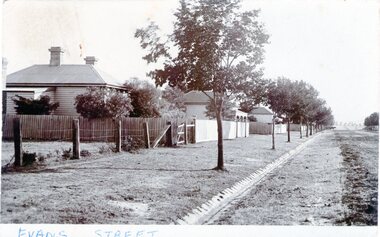
Photograph - Evans Street, Sunbury, c1880 - 1900s
The photograph shows a picture of Evans Street Sunbury taken from the T intersection at Macedon Street and looking south. When the photograph was taken it was one of Sunbury's main residential areas. Since the 1980s the houses in the image have been demolished and replaced with commercial development.- Over the years Evans Street has undergone much change from being a residential strip to being the main commercial hub in Sunbury.– An enlarged photograph of a streetscape with a row of trees growing along the footpath and a number of weatherboard Victorian style double fronted cottages. Both the roadway and footpath are not surfaced and the gutter is lined with stone pavers.sunbury -
 Hume City Civic Collection
Photograph, St. Mary's Church, Bulla, 1970S
... church set in an open area with a line of gum trees... of a small bluestone church set in an open area with a line of gum ...The church in the image is St. Mary's Church of England in Bulla after it was moved from its original location at the corner of Oaklands and Sunbury Roads to the Bulla township adjacent to the former Bulla Shire Officers. The move was necessary because the building was close to the international airport and its location interfered with the airport's signaling system and cracks were appearing in its structure from vibrations caused by lowlying aircraft.A coloured non-digital photograph of a small bluestone church set in an open area with a line of gum trees in the background.churches, st. mary's anglican church - bulla, bulla, tullamarine airport -
 Mt Dandenong & District Historical Society Inc.
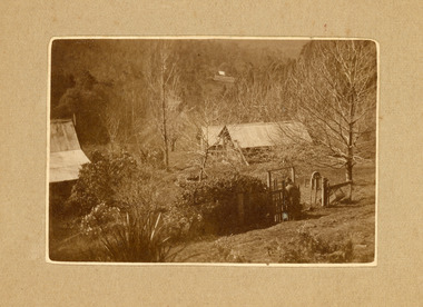
Photograph
The photograph belonged to Frank Child and shows the homestead belonging to his grandparents Ted and Ethel Child situated on Childs Road at Kalorama. Francis Matthew (Frank) Child (1928 – 2020) was the son of Bernard Child (1907 – 1995). Bernard was the son of Ethel May Madden and an unknown father. When Ethel married Ted Child in 1908 Bernard was raised by Ted’s parents Francis and Martha Child. Bernard married Dulcie Paice (1904 – 1990) and they had one son, Frank Child, before they divorced in 1943.Small sepia photograph showing a woman entering the gateway to a homestead. The trees have lost their leaves and their are shrubs along the fence line. Two sheds can be seen to the right with a homestead roof to the left.Handwritten on reverse: Home of Ethel + Ted Child Childs Rd Kaloramafrank child, ted child, ethel child, childs road, kalorama, homestead -
 Mt Dandenong & District Historical Society Inc.
Photograph, Post Office and 'Mountjoy', Mt. Dandenong North, 1913
Rose Series post card #182Copy of Rose Series postcard #182 showing Kalorama Gap in 1913. Haystacks in foreground with Mountjoy Guest House and Beulah Tea Rooms/Mt Dandenong North Post Office in centre. This photograph has a detailed inscription on the back handwritten by John Lundy-Clarke in 1974.Kalorama Gap in 1913 The elm trees are in the centre of the picture. One of these is really two as two suckers of the further tree were twisted together by Fred Jeeves in 1898 and grew as one tree. The other was planted in 1880. The shop is the shop of Mrs Eliza Hand and daughter Florence. The closed in far end of the verandah was the Mount Dandenong North Post Office. The large house is “Mountjoy” owned and run by the Jeeves Family from 1908 till 1943. It was built in 1905 by the Paynters who sold to Ellis Jeeves in 1908.He moved his line of coaches from “Kalorama” his old homestead and housed the horses in a line of stables behind “Mountjoy”. Price’s house, which contained their shop, the first one on the mountain, opened 1906, can be seen faintly behind the pine tree opposite the bend in the road, which was the main road then and now is Ridge Road. The Price’s house just shows in two tiny pieces, one on each side of the pine tree half way up. The house to the right of and high up the pine tree is Walker’s cottage which exists today opposite Jack Kidd’s home at the far edge of Lt 2 Village Settlement and was between Main Road and Barbers Road which runs down the left behind the elms. Walker’s homestead can be seen near left edge of picture 2/3 way up. The roof of the Methodist Church shows among trees left of picture. This, like Mrs Hand’s shop was built on portions separated from Isaac Jeeves’ Selection “C” known as Jeeves Saddle. kalorama gap, five ways, mountjoy, john lundy-clarke, beulah tea rooms, post office, fred jeeves, paynter, jeeves, frederick jeeves, price, walker, jack kidd -
 Mt Dandenong & District Historical Society Inc.
Photograph, View of valley looking south over 'Kalorama' towards falls, 1908
View taken 1908 looking south over 'Kalorama', home of Ellis and Eliza Jeeves, across the valley towards the falls.This photograph has a detailed inscription on the back handwritten by John Lundy-Clarke in 1974.View taken 1908 of valley looking south over “Kalorama” towards the falls. House right of “Kalorama” was Paynter’s “Iona” on Lot 29. Faintly below line of Barber’s Road above “Kalorama” is Logan’s house on Lot 28. House against orchard was Pimm’s later Prince’s Lot 19. Big trees on right were on Price’s Lot 18 and were between Tosari Rd and Rosemont Cres. It was FROM one of these being cut up in 1931 that the round length log weighing ½ a ton got away from the splitters and raced down the hill in bounces, one of which cleared Barber’s Rd and Logan’s house in leaping from the fence line above the road.kalorama, paynter, iona, barbers road, ellis jeeves -
 8th/13th Victorian Mounted Rifles Regimental Collection
Photograph
Light Aid Detachment was a permanent attachment of RAEME tradesmen to an armoured regiment to provide first line repair of vehicles.Black and white photograph of workshop vehicle and trailer in copse of trees at Puckapunyal with Centurion tank being repaired. Annual 8/13 Victorian Mounted Rifles Camp 1971." WO !! Royce Haydon LAD ( Light Aid Detachment ) in the field A Sqn." -
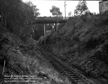 Southern Sherbrooke Historical Society Inc.
Photograph, Belgrave Railway Bridge, 1947
Belgrave Railway Bridge seen from near railway line on the east side. Photo shows the bridge over a scrubby railway cutting. There are small trees. A truck is parked on the right side of the bridge and perpendicular to the bridge. To the right is a building, presumably US Motors. A sign visible on right end of the bridge is also visible on VSSHP0069.02. -
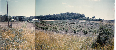 Southern Sherbrooke Historical Society Inc.
Photograph - Photo-colour- Montague apple orchard, 1954
Colour photograph of Bill and Stella Montague's original house with the orchard that was planted in 1952 in the foreground. The home of Alf and Marion Montague (Bill's parents) is on the left. A line on the left side indicates this is two photos stuck together to form a panorama. Trees in orchard appear to be quite young. -
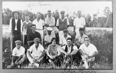 Southern Sherbrooke Historical Society Inc.
Photograph - Menzies Creek Cricket Club, undated
B&W team photo of the Menzies Creek Cricket Club. Back row: Mr Horrie Willis (umpire) wearing a broad brimmed hat and waistcoat over a collarless shirt, Bill Hermon,Fred Beauchamp, Doug McLean, Wally Appleby. Middle row: Jim Norton, Gordon Willis, Bill Condon, Harold Dunham. Front row: Ernie Dunham, Jack Worrell, Edna Simmons (scorer) holding a book, Stan Hermon, Vic Bennett.The two Hermon boys are named on the photo. The team members are dressed in an assortment of cricket whites and everyday clothes. They are lined up in low scrub. Further behind is a cleared playing area, with trees beyond that. To their left are two hats on the ground. Five team members are wearing peaked caps or cricket caps. -
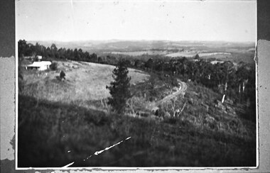 Southern Sherbrooke Historical Society Inc.
Photograph - Puffing Billy line near The Tanks
B&W photo of the Puffing Billy line near The Tanks below Glen Park Farm. On the left is the house of the Dunham family, with shedding in the background. The land slopes down to the track then falls quite steeply away to a treed area. In the distance can be seen land which is now part of Cardinia Reservoir. -
 Southern Sherbrooke Historical Society Inc.
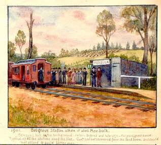
Photograph - 1906 railway accident, Belgrave
Watercolour painting by Charlie Hammond showing two train carriages at Belgrave Station. A group of people stand on the small platform beside the small station building which bears the sign 'Monbulk'. In the background are hilly paddocks. The most distant paddock has rows of what appear to be fruit trees. Below the painting Hammond has written '1901 Belgrave Station when it was Monbulk. Benson's Hill in the background. Later – Biffin's and later still – Harper's Guest House. Typical of all the stations along the line. Govt. had not recovered from the land boom and could not afford to build better ones.' This painting is based on a photo taken by Hammond in 1906, which is labelled by him, 'Sunday 28th Jany 1906. bringing the injured passengers to Belgrave Ry Station after the accident at the trestle bridge.' -
 Southern Sherbrooke Historical Society Inc.
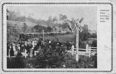
Postcard - Gembrook Train Leaving Fern Tree Gully
B&W postcard, 'Gembrook Train Leaving Fern Tree Gully'. The postcard has a photo of a level crossing at Ferntree Gully. The down train has just cleared the crossing and a large group have either just crossed the line or are about to. One woman is carrying an umbrella. A horse-drawn carriage is in the process of crossing the track, obscured by a large shrub. There is a warning sign at the crossing saying 'Railway Crossing, Look out for trains'. Behind the train is a hill with scattered trees. The photo has a patterned, printed frame around it. On the back of the postcard is a written message. 'Am sending ad/vanced birthday/ cards to the/ little girls with/ love. Had a letter from Addie last/ week. A.S. Hunt' and in the address panel, 'Mrs W. Upton/ Wyndham/ Werribee.' A postage stamp has been removed from the card, obscuring the date stamp. -
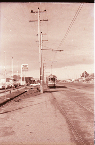
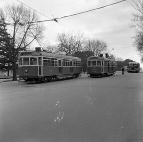
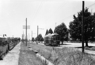
 Ballarat Tramway Museum
Photograph - Black & White Photograph/s, Len Millar, Oct. 1970
Yields information about the tram services in Ballarat in particular the Lydiard St line.Black and white photograph of card SEC tram 34 in Lydiard St North, Oct 1970. The photographer notes the elm trees. Detailed notes on rear in ink and pencil by Len Millar and Keith Kings - see image i2.trams, tramways, lydiard st north, tram 34 -
 Ballarat Tramway Museum
Slide - 27 mm sq slide/s - set of 20 - BTPS Official opening, Lilian Butler, 1/02/1975
Yields information about the Official opening of the BTPS operation in Wendouree Parade in 1974 and has a strong association with those involved.Set of 20 Kodachrome of the Official Opening day of the BTPS Wendouree Parade tramway. .1 - BTPS Depot and associated trackwork with two people sitting on the door step. .2 - 40 and three single truckers lined up for the opening ceremony .3 - ditto .4 - Opening ceremony with speeches etc, the band (The Ballarat Memorial Soldiers Band) .5 - ditto .6 - ditto .7 - ditto .8 - ditto .9 - Bill Jessup holding the opening banner just after being broken - Clyde Croft in the cabin of the tram. .10 - close up of the front of 40 .11 - trams in Wendouree Parade] .12 - ditto .13 - 14 passing another tram at the loop .14 - 40 ditto .15 - Some enthusiasts hiding under the trees. .16 - turning the pole .17 - Gavin Young and Graham Jordan standing on front of 26 .18 - ditto .19 - putting the pole on the overhead .20 - Former driver? standing at the No. 2 end of 40. Photos from the collection of Lilian Butler. ballarat, tramways, trams, btps, wendouree parade, opening day, tram 40, tram 14, tram 27, tram 26 -
 Ballarat Tramway Museum
Negative - Set of 4, Campbell Duncan, 2/07/1971 12:00:00 AM
Yields information about tram operations and the street views on the Sebastopol line.Set of 4 photographs taken on 28/2/1971 by Campbell Duncan of trams on the Sebastopol line in Albert St. .1 - No. 35 outbound to Sebastopol, in Albert St passing Eclipse motors. .2 - No. 35 inbound near Ophir St about to cross Albert St with a grader alongside. .3 - ditto with the church in the background - Holy Trinity .4 - view looking along Skipton St with a large tree in the foreground.trams, tramways, sebastopol, albert st, ophir st, anglican church, skipton st, tram 35 -
 Ballarat Tramway Museum
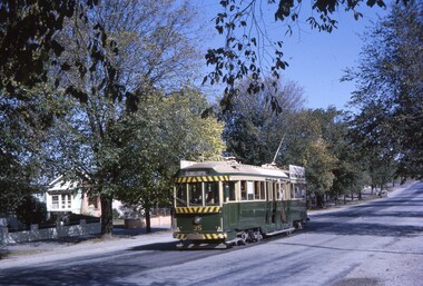
Slide - 35mm slide/s, Robert Thomson, 2/04/1964 12:00:00 AM
Yields information about Ballarat's trams during 1964 and the Lydiard St North line and its appearance.Kodak Kodachrome cardboard mount, colour slide of tram 35 southbound in Lydiard St North with the destination of Sebastopol. Has an autumn tree background."Bogie 35 Lydiard 2-4-64" in ink.tramways, trams, lydiard st north, tram 35 -
 Ballarat Tramway Museum
Slide - 35mm slide/s - set of 9, Noel Simons, Sept. 1971
Set of 9 Kodak Ready-mount with slides made from the Association of Railway Enthusiast Provincial Tramways film strip. Reference Item 2560 details the ARE Film Strip, and provide references to other slides. See also Reg. item 1164. 1174.9 on plain white mount. 1174.1 - Tram 40 North bound for Lydiard St. North at the Railway Gates, with the gates closed. Tram carrying a heavy load of passengers. Railway station building and car park in background. Taken from the signal box. 1174.2 - Tram 12 bound for Gardens, photographed across the median strip plantation near Dawson St. Image i2a - adjusted 9/2021 to remove colour cast. 1174.3 - Tram 43 in bound along Wendouree Parade near Barrett Ave, passing a former tram stop and with "Warning Oncoming Trams" sign mounted on an adjacent pole. See also Reg. item 1172.1 for a photo taken in May 1971. This photo taken after the closure of the Victoria St. line, as the tram stop has been painted out. 1174.4 - Looking along the track to Sebastopol terminus on the west side of Albert St. - telephoto shot showing bogie tram in the far distance. Shows the nature of the track, poles, tram stop frequency and in the fare distance the terminus. Also show the trees that used to be along this section of the track. 1174.5 - No. 42 showing "Special" in Macarthur St. approaching Drummond St. north. Photo taken from under the verandah of a shop on the south side of the street that were many years later to become the Tramcar Restaurant. Note metal fence to cemetery. 1174.6 - Nos. 21 (Sebastopol) crossing 14 (Lydiard St. Nth) at the loop between Sayle and Grey St. Photo taken looking south. 1174.7 - No. 12 bound for Mt Pleasant, in Bridge St. about to stop at the junction for the two routes. Telephoto photo looking west along Bridge St. with many cars in the photo. Very few people on the street itself. 1174.8 - No. 30 and 17 at the City Terminus, on the north side of Sturt St. Taken from the Post Office corner with the Town Hall in the background. 1174.9 - No. 39 inbound along Sturt St. West. with many cars on the road. Bus stop on a pole on the other side of the road.1174.1 - "No. 40 on Lydiard St. North service waits at the level crossing at Ballarat Railway Station." 1174.2 - "No. 12 bound for 'Gardens' seen across the centre plantation in Sturt St." 1174.3 - "Barrett Ave." 1174.4 - "The Sebastopol route near the terminus" 1174.6 - "Nos. 21 and 14 crossing at Sayle St. Loop on Sebastopol route" 1174.7 - "No. 12 at Eastern end of Bridge St." 1174.8 - "Nos. 30 and 17 in Sturt St. at Cnr of Lydiard St." 1174.9 - "No. 39 City bound from 'Gardens" in Sturt St. West" All have date stamp of "Sep 1971" in black ink. Writing in blue ink.tramways, trams, lydiard st. nth, railway crossing, sturt st, wendouree parade, sebastopol, macarthur st., bridge st., sturt st. west, tram 12, tram 14, tram 17, tram 21, tram 30, tram 39, tram 40, tram 42, tram 43 -
 Ballarat Tramway Museum
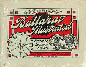
Book, "Ballarat Illustrated", 1972
Original c 1914 (see below), facsimile copy - re-published 1972. Original features photos of Ballarat City and Town, its buildings, parks and the various industries and organisations that were in Ballarat at the time of publication, including ESCo. Many photos features ESCo trams. Photos sepia toned. Has some red colour block printing on the front cover and rear, for Star Oil Engines. On inside back cover is a map with the places of interest and tram route map, marked in red. Pages are un-numbered. Original published by Ballarat East Town Council and Ballaarat City Council. On cover has number stamped in black in, "No. 87" (assume facsimile copy No.). Photos with publication show tram No. 21, built 1913 and ESCo photo page shows Mr. Pringle as Manager. Mr Pringle became manager in January 1911, As there is no photos of the "Avenue of Honour", or other mention of the first world war, assume original published about 1913 or 1914. Original shows Engravings and printing by "Campbell Wilson Prop Ltd, Ballarat". See Other Information as well for more listing details. High Resolution image added 31/8/2012 of i2 of ESCo page and i3 for Ballarat identies and sheet i4 extracted for Mr Pringle. PDF scan of full document added 21/5/2019 - see images btm633-1i.pdf and btm633-2i.pdf Notes on "Ballarat Illustrated" Reg. Item No. 733 From notes made by Neville Gower 12/1/1997 Cover: Inside front cover: Last paragraph, "Facilities for Travelling" - Electric trams serve all parts of Ballarat. Page 3: Street Scene, Municipal Town Hall, showing tram wiring Page 7: Street Scene, Lydiard St. North, intersection and tramway centre, with ESCo tram No. 21 in the bottom photo. Other photos features trams as well in Sturt St and Lydiard St. North. Page 9: Street Scene, Top photo of Sturt St. from Lydiard St. looking east, shows piles on right-hand side of road. Car parked by Post Office has a car registration number "9007". Bottom photo, an tram climbing hill, shows double trolley in the street, with early English type of pull offs. Page 13: Street Scenes and Historic Buildings: One of five photos, shows Victoria St. looking East, with tram track prominent in photo and how stone work was set up about the rails and overhead poles. Page 23: Street scene, Gardens North Entrance gates, shows details of gates near St. Aidans Drive. Note double trolley wire on poles, and style of insulators. No trams in photo, three ladies walking down the track. Page 37: Street Scene; Lydiard St views, top left hand photo, shows Railway station and railway gates with signal gantry and horse drawn vehicles. Tram tracks apparent. Bottom left hand photo shows Lydiard St. North, near Post Office, double track with centre poles - Single wire per track. Top right hand photo, showing Cemetery gates in background. Bottom right hand photo - from north end of Lydiard St. South, looking north, with an ESCo tram in background. Also has a parked car on left hand side. Page 45: Street Scenes - Bridge St; top photo at west end of Bridge St. with ESCo No. 11 with possibly double trolley wire in photo. Bottom photo at east end of Bridge St. with tram in background, shows junction. Double trolley heading out to Mt. Pleasant, single trolley for Victoria St. Page 45: Street Scenes - Bridge St; top photo at west end of Bridge St. with ESCo No. 11 with possibly double trolley wire in photo. Bottom photo at east end of Bridge St. with tram in background, shows junction. Double trolley heading out to Mt. Pleasant, single trolley for Victoria St. Page 61: Street Scenes and Historic Buildings - Public Institutions Ballarat - top left hand photo of the Hospital shows some tram track in foreground, with double trolley wire. Top right photo is of the Orphanage, the name of the tram terminus for many years. Page 68: Electric Supply Co. of Victoria's pages - top photo showing powerhouse in background, across the lake, can hardly see anything for the trees, except for the chimney. Bottom photos of the steam Turbo Generators and the switchboard. Gives Mr. P.J. Pringle as Chief Engineer and General Manager. He took over in Jan. 1911. Page 69: Ballarat East Views - features photo of Black Hill open cut, Ballarat East Railway Station, Ballarat Fire Station and "Victoria St. looking East", repeat of photo printed on page 12, but slightly darker. Image on system includes fire station and railway station, - Ballarat East. Page 78: Series of photos of various Ballarat VIP's of the era, fourth one in on top line features "P.J.Pringle, Electric Supply Co." Inside Back cover - map of Ballarat including tram lines and places of interest marked in red. Gives a detailed photographic presentation of Ballarat in 1914.80 page book with, in addition, light green card covers, titled "Ballarat Illustrated". Loose copy of page 9 and 10 held.trams, tramways, ballarat, local history, heritage buildings, esco -
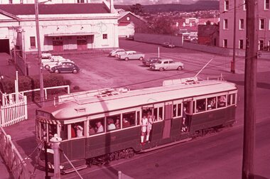
 Ballarat Tramway Museum
Photograph - Black & White Photograph/s, Geoff Grant, 19/06/1955 12:00:00 AM
Black & White photo of M&MTB trams 988 and 1003 in Nicholson St, south of Albert St. intersection, testing overhead prior to opening of Bourke St. on 19/6/1955. Were the first and second trams on the line. Bus on right side of photo. Trees and park in background. Parliament Gardens out of view on right side. Negative scanned hi res and imaged updated 22/5/2020.On rear of photo in typed paper "988 stands while 1003 passes it on the Bourke St. route before any cars had started operating on this newly completed line. These cars were first and second cars to run over the line. 19 June 1955 Geoff Grant Photo." and "Geoff Grant" stamp in btm rh corner.trams, tramways, melbourne, bourke st, commissioning , tram 988, tram 1003 -
 Ballarat Tramway Museum
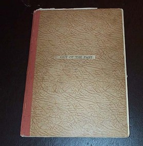
Book, H.P. James, "Out of the Past", 1940
ESCo Employee Hours Work Record book that has been used by an ESCo/SEC inspector, H. P. James as a record / note book for his personal collection or papers or journal titled "Out of the Past". Book sewn with string in 36 page sections, blank end papers, board covers with stipple paper out sides and Rexene cloth binding. Comprising plain paper end papers and 104 printed pages (52 leaves), with each sheet printed in black on feint ruled paper for recording the hours worked and other details of drivers and conductors employed by ESCo. Printed for daily use, with Day and date page headings - made out for the 1930's. Images: Book - i1 Inside front cover - i2 Members Certificate - i3 Has been used to gather mementos such as photos, articles, newspaper clippings, letters and other miscellaneous documents on Ballarat local history. Newspaper cuttings etc often have side notes written by Mr. James. Inside front cover has certificate recording Mr. James membership to the Ballarat Historical Society for 1940. Receipt signed by Edward Crimmins. Also a newspaper cutting on the cost of pensions to Lord Nelson's family. On facing page a photo of Queen Elizabeth, a printer colour cover or sheet about Walt Disney's "Pinocchio", a newspaper cutting regarding Father's Day and a black and white photograph of a young girl in a hospital carriage being pushed by a man. Pages numbered odd numbers only in the top right hand corner in pencil. Primary items are: 1 - Coloured cover to a writing tablet, titled "Australian Birds". Underlying this on the back of the writing tablet is two newspaper cuttings: the Ballarat Historical Society - reports on the 6th Annual meeting of the Society. 3 - Photo of the pattern Ballaarat Horse Tram company tram outside the Duncan and Fraser's Carriage Works in Adelaide with hand written notes underneath, including a sketch of a horse tram drivers seat - see Reg. Item 2527. 4, 6 - Group of nine black and white printed cards (15 illustrations) of early Ballarat pasted onto the sheet - see Reg. Item 2528. 5, 7 & 9 - Printed notes titled "Valedictory to Bob Haines" - see Reg. Item 2529. On page 9 in the left hand margin, a printed list of Church Officers; Church of England. 8 - Newspaper cuttings titled "The Heralds Man's Quiz" and the answers adjacent. City of Ballaarat - Public Inoculation Depot - Influenza form for HP James of ESCo - See Reg. Item 2530. Page Numbering from this point changes - even numbers in top right hand corner of folios instead of odd numbers. 9A - Newspaper cuttings about a Theatre Show, 54 years service of Mr. E. R. Bodycomb (Ballarat Gas) and planting of trees in the Avenue of Honour - with a red line around H. P. James names and a reproduction of the opening photograph of ESCo Electric Trams - noting 30 years ago - See Reg. Item 310.2. ESCo 4d Ticket - Purple - Grenville St to Sebastopol Terminus - See Reg Item 2531. ESCo 3d Adult Transfer Ticket - See Reg. Item 2532. Illustration - cartoon - H.P. James - See Reg. Item 2533. 10 - Newspaper cutting "From Horse Tram to Trolley Bus" - See Reg Item 2534. Newspaper cutting "Melbourne's First Tramcars" - See Reg Item 2535. An inscription or written note from T. Thomas etc. on lower edge of the sheet. 11,12 - Newspaper cuttings about the Passing of Melbourne's Cable Trams, including a photo of cable trailer No. 1 - See Reg. Item 2536. Other cuttings about early residents of the Ballarat district. 13 - Newspaper cutting dated 2/5/1936 about the donation from the CTA to the Ballarat Hospital. 14 - Newspaper cuttings - Photo of Ballarat Bicycle and Tricycle Club in the Gardens, the issue of a stamp to commemorate the Centenary of Ballarat, radio stations in Sydney, Ballarat Choirs and fire brigade demonstrations trophies. 16 - Copy of the "City of Ballaarat Regulation No. 13" concerning Hackney and Stage coaches working within the City - See Reg. item 2537. 18, 20 - Newspaper cutting - "The Working Classes in Early Ballarat" - Nathan Spielvogel 21 - handwritten note on "Doctor" Thomas Blackett who died during 1940. 22 - Miscellaneous cuttings from the Melbourne Sun. 23 - Newspaper cuttings "Story of South Street", Show Grounds, and "The Alfred" Hall and a photograph of the 1938 Floral Carpet at Alfred Hall. 24 - Newspaper cutting - obituary and hand written note on Ballarat identity Mr. J. P. Bourke. 25 - Newspaper cutting - cartoon "Tiddley" Winks and Wally - Stan Cross (later "Wally and the Major" 26 - Newspaper cutting - "Ballarat in the sixties" - General R.E. Williams and "Early Recollections" - Arthur Reid. 27 - Handwritten note re Mrs. Bill Danks, dated Jan. 1941 - Tobacconist in Bridge St. 28 - Newspaper cutting - "First Town Hall" and note on "City Hall". 30 - Newspaper cuttings - "Good Friday, Now and Then - T.P. Long, Mont Albert and "On Fashions" James R. Pound. 32 - Newspaper cutting "School and School life in old Ballarat" - Nathan F. Spielvogel. 34 - Newspaper cutting continued from page 32 and Obituary - Mr. Archie Dawson and Tom Blackett. 35 - Newspaper cutting of Ballarat - 4 photos - include Bridge St. with a tram. 36 - Newspaper cutting - "Ballarat - Pastoral and Industrial Resources" from a Melbourne paper, 17/2/1940. 38 - Newspaper cuttings - obituaries - Mr. R. E. Tunbridge, Graeme Dowling and Thomas Crosthwaite. 39 - Illustration - black and white - Late Mr. P. J. Pringle - See Reg. Item 2538. 40 - Handwritten notes on Ballarat Trams and the power station staff - See Reg. Item 2539. 41 - Handwritten notes on Ballarat Pie Stalls 42 - Newspaper cuttings - cartoon "Professor Nimbus", photo of the Norwegian town of Hell (Railway station); bicycles on a Copenhagen bridge following German occupation and dragon flies in Melbourne. 43 - Newspaper cutting on the official opening of the Ballarat Historical Society's Museum. 44 - Newspaper cuttings and associated handwritten notes on a fire in Ballarat, poultry fanciers, historical dates for August. 46 - Newspaper cuttings - "Victoria's first profitable goldfield" - Ballarat and the unveiling of the Sovereign Hill direction pillar. 48 - Newspaper cutting - "Worked 27 years without holiday" - See Reg. Item. 2540. - Other newspaper cuttings - thoughts of a visitor to Ballarat from Sydney and H.P. James - Liquor control in Ballarat and "This Week at the Zoo". 50 - Handwritten notes on clothing. 51 - Handwritten note on a visit to W. H. Middleton 52 - Newspaper cuttings "The Kings Empire", "Ballarat Birthdays" for Sept and Oct and an obituary on Mr. W. H. Middleton. 54 - Newspaper cuttings "Richmond has Links With Early Goldfields" - Malcolm McCullum and "England's Greatest Battle" 55, 56 - Newspaper cuttings - "Ballarat Birthdays" for November and December, a photograph of Nick Oliver - former Ballarat fireman and "Railway Birthday" - birth of the VR. 57, 58 - Handwritten notes on Ballarat tram timetables, weekly tickets, motorman's record cards, tourist tickets and sample tickets or cards, See Reg. Item 2541. Lunch Hour Weekly Ticket - Reg. Item 2542 Morning and Evening Weekly Ticket - Reg. Item 2543 Motorman's Record - Reg. Item 2544 Tourist Ticket - 1/- - Reg. Item 2545. 60 - Newspaper cuttings - parts 1 and 2 - "The Two Ballarat" by Nathan Spielvogel. 62 - Newspaper cuttings - continued from page 60, the death of comedians Sam Mayo and Gus Bluett and some handwritten notes on comedians. 64 - Newspaper cuttings on cricket, choir rules, a Methodist ladies function at the home of H.P. James, Footballer Percy Beames and entertaining air force recruits at the showgrounds. 66 - Newspaper cuttings - "The Anvil Chorus" - Hitler and Mussolini and "Strength against Nazi Threat". 68 - Newspaper cuttings - 50 years ago in Ballarat, Social function at H.P. James house, coldest morning in Ballarat and the death of Col. A. W. Bennett. 70 - Newspaper cuttings - about the sale of spirits in early Ballarat, the first motorcars in Ballarat and handwritten note about Mr. Jago. 72 - Newspaper cuttings - misc. about horse racing, trainers and racing. 73 - Newspaper cuttings and handwritten notes about Ballarat Schools. 74 - Newspaper cuttings - Bruno Hauptmann (Charles Lindbergh) and the death of actor Darcy Kelway. 75, 76 - Newspaper cuttings - Rail services to and from Ballarat, effects of the war and Ballarat 70 years ago, the invasions of Britain and "A stroll down Memory Lane" - T.P. Long of Mont Albert. 77,78 - Newspaper cuttings - Lake Wendouree - Nathan Spielvogel, the opening of the new Ballarat Historical Society's Museum and farewell function of Mr. James Shannon. 79 - Newspaper cuttings - about boats on lake Wendouree. 99 - Obituary and hand written note re Mr. Arthur M. David. 100 - Newspaper cuttings - cartoon "Wally and the Major", Dr William Maloney, Gus Bluett and "Old Rowley" - in connection with the Melbourne Cup of 1940. 101 - Cartoon advertisement for Kolynos Dental Cream Inside rear cover - Programme for the Centenary of Thanksgiving Service - Back to Ballarat 1934, dated 4/11/1934 (has been affected by other sheets of paper due to their acidic nature), printed notes titled "A ramble on stilts with Freddie" written by Baker James. Many in pencil and inktrams, tramways, h.p. james, esco, horse trams, ballarat, civic history -
 Ballarat Tramway Museum
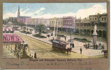
Postcard, "Shoppee and Alexandra Squares Ballarat Vic.", c1904
Printed colour postcard from top of the Town Hall, looking northwest with Snows building in the foreground looking west. Has a horse tram travelling up to Lydiard St. on the south side of Sturt St. Has the buildings on north side of Sturt St. in the view, including the central median reserve before the trees had grown. Titled "Shoppee and Alexandra Squares, Ballarat Vic." along the bottom edge. On the bottom of the postcard is a one line hand written message, ink fading, very hard to read. On rear of postcard is the address to a Mr Frank Tucker, Glencairn, Park Avenue, Harrogate, England. Has two Victorian stamps, half penny (green) and one penny (red) stamps. Has been postmarked, "Ballarat East 16.11.04". See images .1 and .2. Two copies held - on the second copy, the address details have been crossed out and the stamp removed. Yields information about central Ballarat in the horse tram days.Postcard - printed colour, divided back, used.trams, tramways, horse trams, sturt st, postcards, snows, tram 3 -
 Ballarat Tramway Museum
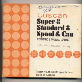
Film - Movie Film & Box, Kodak, 1960
Yields information in movie film format of Ballarat trams in 1960, how the system operated and was used by people., Yields information in movie film format of Ballarat trams in 1960, how the system operated and was used by people.Movie film - 8mm, approx. 17.5 mins, with leader strip on a plastic reel, within a black and white plastic box, titled "Ballarat No. 1. 1960" contained with a cardboard box, 'Tuscan Super 8 and Standard 8 Spool and Can' . Has been transferred to DVD - see Reg item 4100 as Segment No. 1. Filmed and made by Ben Parle. Also transferred to DVD by Rod Cook Oct. 2015, via Roger Greenwood for use in his DVD, "The City of Ballarat Trams, Gardens & Gold" of 2016. See Reg Item 6883. Synopsis: based on time. 0:00 Starts with bogies cars crossing railway level crossing (34?, 39?) 0:30 SEC Logo 0:45 Ballarat Station sign and intro “Some City Scenes” 0:49 35 turning from Lydiard St Nth to Sturt St towards Grenville St with Commonwealth Bank in view. and then 42 returning 1:19 42 showing Mt Pleasant, turns from Sturt St into Lydiard St Nth 1:53 Tramway road works in Lydiard St Nth, near intersection with Mair St with Jelbart Road roller in use, starts with an SEC roadworks sign. 2:12 39 passing the works out bound to Lydiard St Nth. 2:46 Good view of the roller working before 35 arrives. 3:01 35 passing the works in bound with 3:29 14 crossing Lydiard St in Sturt St, towards Grenville St 3:47 Trams in City Loop 3:55 21 coming up the hill 4:04 31 entering Bridge St from Sturt St with Bucks Head Hotel in the background. 4:27 Overhead work at corner of Sturt and Lydiard, with view of the sign at the City terminus “Trams leave here for Sebastopol, Gardens, View Point.” 4:34 Passengers getting off and then onto 38, ex Lydiard St Nth at city terminus including a young lady wearing gloves and a wheeling a pram hurriedly the photographer. A number of other prams in the view as well as. The Conductor helps to unload the pram. 5:07 41 proceeding up Sturt St, appears to have just rained. 5:26 11 using the Dawson St crossover, with a motor car doing a U turn as well. 6:00 14 descending Sturt St towards the City, filmed at Dawson St. 6:11 Title “The Gardens via Drummond St North Line” 6:16 19 showing Victoria St, turning from Drummond St Nth into Sturt St. 6:28 30 inbound in Drummond St Nth, approach and trailing shots. Trailing shot ahs the hospital in the background. 6:49 31 outbound, Drummond St Nth, approach and trailing shots, trees are in autumn colours. 7:04 12, inbound Drummond St Nth, with Macarthur St in the background, stopping to pick up a lady, approach and trailing shots and then entering the Mill St crossing loop. 7:53 14 outbound in Drummond St Nth, dropping a lady passenger off and then turning into Macarthur St and then tram going away. 8:37 View of overhead junction at View Point Jtn. 8:45 View of “Cars Stop Here” sign and pole sign “To City Only” 8:55 30 inbound in Wendouree Parade, stops to pick up passenger, and then a trailing shot of tram entering Macarthur St loop 9:37 View of “Cars Stop Here”, “End of Section” and timetable boards at Haddon St. 9:50 34, pausing at Haddon St and then proceeding towards depot – approach and trailing shots, with “Warning Oncoming Trams” sign in shot. 10:27 “Warning Oncoming Trams” sign 10:32 34 crossing 12 at the Martin Ave loop 10:48 39? Wendouree Parade, near Barrett Ave, stopping and letting off passengers. 11:24 30 passing depot junction and then trailing shot of it entering Tram Sheds or Depot Loop and then proceeding towards the City. 12:11 Shot of the “Caution Beware of Trams” sign at the depot. 12:14 25 stopping at depot junction and then trailing shot of it going toward Forrest St. 12:47 12 passing Depot Junction, trailing shot. 13:07 Shot of :Electricity Supply Department, Ballarat Branch” sign at depot. 13:13 View of a destination showing “Depot” on a bogie tram 13:15 Title “Some Depot Scenes” 13:19 View of a trolley pole and then 13 leaving the depot through the gates, destination showing “View Point”. 13:54 View of trolley pole and then 32 stopping at the depot gates. 14:08 12 (Sunny view) running out onto Wendouree Parade and then a bogie tram approaching Depot Loop. 14:43 View of 42 running in with a single trucker behind in Wendouree Parade, and another single trucker running out. 15:02 Title “Some Scenes in the Gardens” 15:05 25 running through the Gardens, approach and trailing shots, near our Depot Junction. 15:55 View of “No Parking East of Loop” sign 15:59 View of overhead and then trackwork (with points removed), but overhead still in position at the Old Gardens Loop or Gardens South Loop and then 12 entering the loop from the south and then a trailing shot looking along the Parade. 16:33 View of “Cars Stop Here” and “End of Section” and then timetable boards at Gardens Loop. 16:55 View of 34 leaving the loop 17:14 Title “The End”Written labels giving title information on outside of box.trams, tramways, ballarat, sebastopol, lydiard st north, victoria st, mt pleasant, sturt st west -
 Ballarat Tramway Museum
Photograph - Black & White Photograph/s, Ron Hann, Jan. 1963
Yields information about the tram line near the Sebastopol terminus, the tram liveries in 1963.Black and white print on heavy matt photographic paper of No. 35 leaving the Sebastopol terminus heading back into the city. In the photograph is the telephone line along the road, passengers waiting at the next stop, trees along Albert St and shows the arrangements of the tram line in association with the street itself. 2nd copy - laser print - with date etc on rear - added 22/2/2010, copy from Ron Hann. Printed on Fujifilm, Fujicolour Crystal Archive for Frontier"On rear in pencil "35 Sebastopo1963" 2nd copy has label "Reference 6/113/9 Photo by Ron Hann" and another label "Ballarat 01.63"tramways, trams, sebastopol, tram 35 -
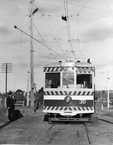 Ballarat Tramway Museum
Photograph - Black & White Photograph/s, Chris Wurr, early 1970's
... Bendigo and its tree lined streets. trams tramways Bendigo North ...Yields information about the appearance of Bendigo Birney trams early 1970's en route to North Bendigo and its tree lined streets.Black and White Photograph of SEC Bendigo 30, Birney at North Bendigo terminus with the driver turning the trolley pole. Tram has the destination of Golden Square. Photo shows the fitting in the overhead to help locate the trolley pole on the inbound wire. Photo Chris Wurr, early 1970's. "Photo by Chris Wurr" stamped on the rear.trams, tramways, bendigo, north bendigo, overhead, birney, tram 30 -
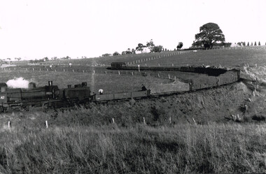 Otway Districts Historical Society
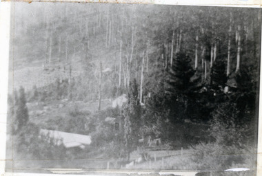
Photograph, Tulloh: last train from Weeaproinah, June 2011
The 1963 Victoria Railways Annual Report stated: "Owing to the paucity of traffic the provision of a regular goods train service on the Colac-Weeaproinah narrow gauge line has involved substantial operating losses in recent years . . . As it was evident that the cost of retaining the service was quite disproportionate to the small amount of traffic offering, the line was closed."B/W. On the 27 June 1962 locomotive G42, 13 NQR wagons, several loaded with wood, and an NC guard's van negotiate Scanlon's curve near Tulloh. Three staff occupy the wagon next to the engine. On the horizon a house amidst a tree.weeaproinah; tulloh; scanlon's curve; railway; colac; beech forest;