Showing 1831 items
matching walks
-
 Orbost & District Historical Society
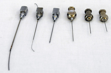
needles, MacGregor Instrument Company, First half 20th century
These veterinary items were found in an old walk-through dairy in Wombat Track, Orbost.These items are representative of items used in Orbost on dairy farms in the first half of 20th century.Six stainless steel needles for use in a syringe.2401.5 has a small length of wire inserted into the needle. 2401.6 also has a small length of wire inserted into the needle.2401.1 : 6 2401.2 : 7(?) 2401.3 : CLINIC 17 2401.4 : 16 2401.5 : S 19 2401.6 : VIM-FIRTH 20dairy farming veterinary-instruments hypodermic-needles -
 Stawell Historical Society Inc
Photograph, Mural in Pioneer Walk Walkway off Main Street . Photographic Committee National Trust Photographs of Stawell
7006 National Trust Photographs Mural in Pioneer Walk Walkway off Main Street Series of Colour Photographs of buildings of interest to National TrustJune 1993buildings, heritage buildings -
Stawell Historical Society Inc
Photograph, Mural in Pioneer Walk Walkway off Main Street. Photographic Committee National Trust Photographs of Stawell
7006 National Trust Photographs Mural in Pioneer Walk Walkway off Main Street Series of Colour Photographs of buildings of interest to National TrustJune 1993buildings, heritage buildings -
 Whitehorse Historical Society Inc.
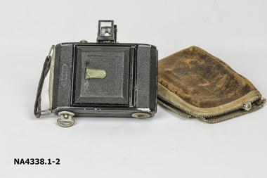
Equipment - Camera ZEISS IKON, 1930
The camera was owned by the donor and her father. They were bushwalkers and took many photos on their walks.Small black oblong camera with fold down view finder and fold out bellows with 7.5cm lens. Camera folds into well worn leather case.IKONTAphotography, cameras -
 Whitehorse Historical Society Inc.
Equipment - Camera
The camera was owned by the donor and her father. They were bushwalkers and took many photos on their walks.Minolta Camera AF-DL Quartz date. Automatic date camera. Made in Japan. No. 1523631.photography, cameras -
 Vision Australia
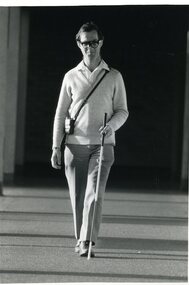
Photograph - Image, Andrew with his sonic guide and white cane, 1987
Andrew walks along an external building verandah using a sonic guide and white cane.1 x B/W photograph of man walking with assistive devicesFile: Skills Training - O&M A white cane provides blind people with early warning of obstacles. (Andrew is also wearing a sonic guide in glasses.) Walking with the aid of sonic guide glasses. Technology for blind people at the Royal Blind Society. Credit: Rankin/1987royal blind society of new south wales, white cane day -
 Vision Australia
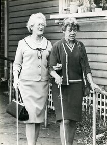
Photograph - Image, Mrs Walker and Mrs Mealing, May 1968
Mrs Walker and Mrs Mealing using their white canes as they walk along a sloping footpath.B/W photograph of two women with white canesMobility - historicalroyal blind society of nsw, white cane day, mrs mealing, mrs walker -
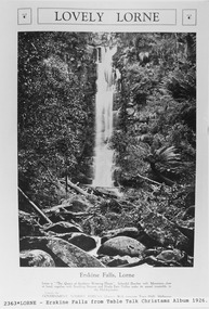 Lorne Historical Society
Pamphlet - Tourist Brochure, Lovely Lorne
The Victorian Railways promoted tourist destinations around Victoria. A folded paper tourist brochure about Lorne The front cover is a coloured painting of Lorne from above the Erskine River towards the main beach. , on the back is a black and white sketch tourist map of the roads, tracks and beauty spots. Inside the first fold are 6 black and white photographs, Cumberland River, Mt St George, Phantom Falls, Cumberland Cliffs, Teddy’s Lookout, leafy walk towards the pier. Inside contains written descriptions of the highlights of Lorne and six black and white photographs, four general views of Lorne, Lover’s Walk, Erskine Falls . souvenirs, victorian railways, publicity -
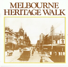 Melbourne Tram Museum
Pamphlet, Photo story Pty Ltd, "Melbourne Heritage Walk", 1985
Pamphlet or small book - 16 pages, centre stapled, printed in sepia colour - titled "Melbourne Heritage Walk" published for Victoria's 150th anniversary in 1985. Features a message from the Lord Mayor, map showing various walks and photographs of street scenes around the central Melbourne area along with heritage notes. Has a list of interesting places to visit. Related to a list of panels that had been provided at the time around the city. Published by Photo story Pty Ltd, Port Melbourne with photos from the RHSV, La Trobe Library, Mitchell Library and sponsored by the Australian Oil Industry.trams, tramways, melbourne, heritage, collins st, swanston st, bourke st, flinders st, russell st -
Glenelg Shire Council Cultural Collection
Souvenir - Sticker - Great South West Walk, n.d
White, oblong sticker with 3 concentric triangles in black, 'GREAT SOUTH' in black, one arm of triangle, 'WEST WALK' in black, opposite arm of triangle, depiction of emu in black, in centre. Sticker mounted on white paper. Sticker in clear cellophane packets.tourism, souvenir of portland, travel, recreation -
 Ringwood and District Historical Society
Flyer, Land Sale Advertisement - State School Estate, Ringwood, Victoria - 1923
The date of the flyer as circa 1920 can be estimated from the references to the (decision on) "electrification of the Croydon Railway Line" which eventually occurred in 1923, letting of tenders for the state school building which opened in 1924, and the "proposed new railway station" (East Ringwood) which opened in 1925, Advertisement for State School Estate, Ringwood - 26 residential allotments for sale near East Ringwood State School development site and 7 minutes walk from proposed new railway station (East Ringwood). Includes location map and terms of sale.Locality plan includes King Street and Government Roads (Later Everard Road, Holland Road, Purser Avenue, and Charles Street). (Agents) J.B. McAlpin, Estate Agent and Subdivisional Manager, Ringwood (Opposite Station), and F.V. Parker, Estate Agent, Main Street, Ringwood. -
 Port Melbourne Historical & Preservation Society
Photograph - J Kitchen & Sons perimeter survey, Woodruff Street, Dec 2013
As the former j Kitchen & Sons site was being cleared, Lionel Layfield, who had worked at the site for many years undertook several pictorial perimeter surveys. These photos were taken in Dec 2013.Series 1 of colour photographs taken by Lionel Layfield as he walked around the perimeter of the J Kitchen & Sons Pty Ltd factory site during the early demolition of most of the buildings. .31-.36 - looking into the factory site from Woodruff Streetindustry - manufacturing, built environment - industrial, business and traders - soaps/candles, j kitchen & sons pty ltd, symex holdings ltd, north port oval, port melbourne cricket and football oval -
 Port Melbourne Historical & Preservation Society
Photograph - J Kitchen & Sons perimeter survey, north corner Ingles and Woodruff Streets, Dec 2013
As the former j Kitchen & Sons site was being cleared, Lionel Layfield, who had worked at the site for many years undertook several pictorial perimeter surveys. These photos were taken in Dec 2013.Series 1 of colour photographs taken by Lionel Layfield as he walked around the perimeter of the J Kitchen & Sons Pty Ltd factory site during the early demolition of most of the buildings. .46-.54- warehouse on North corner of Ingles and Woodruff streetsindustry - manufacturing, built environment - industrial, business and traders - soaps/candles, j kitchen & sons pty ltd, symex holdings ltd, north port oval, port melbourne cricket and football oval -
 Whitehorse Historical Society Inc.
Leisure object - Doll, c 1965
Belonged to Kelly Gardener. Brought back from Hong Kong by Myrtle Bennett from a cruise to JapanPlastic doll with brown eyes which can shut and open; long blond hair. Dressed in red and black check skirt with lace trim; blue blouse with red buttons down front; red shoes. Doll can walk and sit up.toys, dolls -
Lakes Entrance Regional Historical Society (operating as Lakes Entrance History Centre & Museum)
Photograph, Judy Davies, 1/08/2003 12:00:00 AM
Also three other colour photographs taken at the same event people named in description. 04677.2, .3 and .4 10 x 15 cmColour photograph of crowd at opening of New Works Walk named are Syd Skogli, Stan Haywood, Betty Smith, David Kendall, Jeanette Robinson, Bob Coate, Shirley and Betty Carpenter, Judy nee Carpenter, Anne Macarthur Lakes Entrance Victoriaboats and boating -
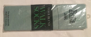 Melbourne Tram Museum
Uniform - Uniform Socks, Bell's, Socks - pair of Bell's Wool blend green Walk Socks, c1990
Socks - pair of Bell's Wool blend green Walk Socks - used by the Public Transport Commission - PTC - for men, contained within a plastic bag which gives the blend details and care instructions on the rear. The plastic bag has a plastic hanger tag.trams, tramways, uniforms, socks, ptc, clothing -
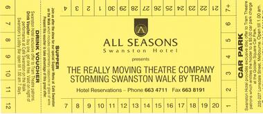 Melbourne Tram Museum
Ephemera - Ticket, All Seasons Swanston Hotel, “The really moving theatre company storming Swanston Walk by Tram”, 1990's?
Ticket - printed on yellow card with numbers 1 to 30 around the outside, for the “The really moving theatre company storming Swanston Walk by Tram”, at the All Seasons Swanston Hotel, with detachable stub for a car parking and a drink voucher at Cafe Swanston. No date on ticket.trams, tramways, theatre, hotels, swanston st, stories -
 National Vietnam Veterans Museum (NVVM)
Photograph, Gibbons, Denis, Walking to work
Denis Gibbons (1937 – 2011) Trained with the Australian Army, before travelling to Vietnam in January 1966, Denis stayed with the 1st Australian Task Force in Nui Dat working as a photographer. For almost five years Gibbons toured with nine Australian infantry battalions, posting compelling war images from within many combat zones before being flown out in late November 1970 after sustaining injuries. The images held within the National Vietnam Veterans Museum make up the Gibbons Collection. A colour photograph of Hue, South Vietnam, Circa 12/1968. Two local Vietnamese girls walk off to their place of work after parking their bikes in the downtown business district of Hue. One girl is wearing an 'AO Dai' (stretch pants and jumper).photograph, hue, ao dai, vietnamese people, gibbons collection catalogue, denis gibbons, photographer, vietnam war -
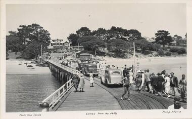 Phillip Island and District Historical Society Inc.
Photograph - Post Cards, A. J. Murray et al, c 1940
A collection of 6 postcards and 1 photograph taken around Phillip Island. Donated by Julie Barnett.Photograph 228-01. Black & White photograph of the Cowes Pier with vehicles and pedestrians. Rail tracks on pier. Isle of Wight Hotel in background. Sheds at end. Photograph 228-02. Black & White aerial photograph of "Broadwater" Guesthouse, Cowes. Photograph 228-03. Black & White photograph of Cowes Pier with Steamer coming in. Shed at end of Jetty and Cenotaph in the foreground. Looking north. Photograph 228-04. Black & White photograph of a Koala and her young. Photograph 228-05. Black & White photograph looking over the Cowes shoreline near Lover's Walk. Photograph 228-06. Black & White photograph of a group of penguins coming home at dusk at the "Penguin Parade". Photograph 228-07. Black & White photograph of Bert West holding a Shearwater (Mutton Bird) with it's wings outstretched.Photo 01. "Photo Shop Series". "Cowes from the Jetty". Photo 02. Aerial view of "Broadwater" Cowes, Phillip Island. No. 146 Photo 03. "Photo Shop Series". The Jetty. Cowes. Photo 04. "Photo Shop Series". "Koala Bear". Phillip Island Photo 05. "The Rose Series P3416". "Near the Lovers' Walk, Cowes, Phillip Is., Vic. Photo 06. "Penguins, Phillip Island." No. 82. Valentines Series. Photo 07. On Back: Mr West with Mutton bird at Phillip Island.wildlife - koalas, wildlife - penguins, penguin parade, bert west, wildlife - mutton birds, mutton birds, shearwaters, cowes pier phillip island, cowes jetty, lover's walk cowes, broadwater guesthouse cowes phillip island, guesthouses cowes phillip island, julie barnett -
 Eltham District Historical Society Inc
Photograph, Liz Pidgeon, Heritage Excursion; East of Eltham, 6 Sep 2014, 20 May 2017
Newsletter No. 218, September 2014 September Excursion - East of Eltham Walk In Newsletter No. 197, March 2011, there was a brief history of Crown Allotment 15 Section 5 Parish of Nillumbik (CA 15) a parcel of land of a quarter of a square mile extending from Eucalyptus Road to Reynolds Road at the eastern extremity of Eltham. From the 1940s it was known as Stokes orchard. In later years it has been subdivided for residential purposes but leaving significant areas as power line and water supply reserves and bushland reserves that are habitat for the threatened For our excursion on 6th September we intend to walk through CA 15 to a bushland reserve east of Reynolds Road. The walk will traverse the boundary between suburban Eltham and the non-urban areas to the south and east. This is a pleasant walk through residential areas and bushland. Along the way we will discuss the early and more recent history of CA 15 as well as local natural history and geology. This walk is about 3.5 km in length and will take 2 to 2.5 hours. It will start at 2pm at the corner of Eucalyptus Road, Pitt Street and Nyora Road.Born Digitaleltham east, eltham district historical society, heritage excursion, activities, nyora road, reynolds road, gum tree road reserve, diosma road, stokes orchard, eucalyptus road -
 Eltham District Historical Society Inc
Photograph, Liz Pidgeon, Heritage Excursion; East of Eltham, 6 Sep 2014, 20 May 2017
Newsletter No. 218, September 2014 September Excursion - East of Eltham Walk In Newsletter No. 197, March 2011, there was a brief history of Crown Allotment 15 Section 5 Parish of Nillumbik (CA 15) a parcel of land of a quarter of a square mile extending from Eucalyptus Road to Reynolds Road at the eastern extremity of Eltham. From the 1940s it was known as Stokes orchard. In later years it has been subdivided for residential purposes but leaving significant areas as power line and water supply reserves and bushland reserves that are habitat for the threatened For our excursion on 6th September we intend to walk through CA 15 to a bushland reserve east of Reynolds Road. The walk will traverse the boundary between suburban Eltham and the non-urban areas to the south and east. This is a pleasant walk through residential areas and bushland. Along the way we will discuss the early and more recent history of CA 15 as well as local natural history and geology. This walk is about 3.5 km in length and will take 2 to 2.5 hours. It will start at 2pm at the corner of Eucalyptus Road, Pitt Street and Nyora Road.Born Digitaleltham east, eltham district historical society, heritage excursion, activities, nyora road, reynolds road, gum tree road reserve, diosma road, stokes orchard, eucalyptus road