Showing 4370 items
matching west street
-
 Charlton Golden Grains Museum Inc
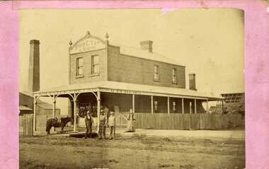
Photograph, Procter & Son Butcher shop, c.1880
... Early photo of Procter & Son Butchers shop c. 1880. West...Early photo of Procter & Son Butchers shop c. 1880. West ...Early photo of Procter & Son Butchers shop c. 1880. West end of High St Charlton. Built as a single fronted, two storey building in September 1880 and extended to triple fronted building in 1884 by C. Procter. The business was previously further west in High Street in one of Peter Johnson's weatherboard shops.Mounted, unframed photo of Procter's Butcher shop. Four people standing in front of shop, two men wearing aprons, a boy and a woman. A horse is tied to a pole in front of the shop. There are many animal carcasses haning in front of the shopprocter & son butcher shop, malcolm's flour mill, charlton, business, industry -
 Bendigo Military Museum
Postcard - POSTCARD, FARNHAM, U.K, Valentine's Series, cWW1
... . Farnham Castle. 4. West Street, Farnham. 5. Parish Church, Farnham... at Flories place. Bob xxxxxx' 3. Farnham Castle. 4. West Street ...1. Florrie is a relative living in Farnham. 2. R.H. Baron married Elsie Keast in 1921. All cards relate to R.H. Baron's visits to Farnham whilst on leave to see Florrie. Part of the 'Robert H. Baron', no.3596 and Cooper Collection. See Catalogue No. 1981P for details of Baron's service.1. Coloured scene of a ruined castle and surrounding gardens. 2. Coloured scene of a garden with building and ruins in background. 3. Coloured photograph of a red brick building with battlement. 4. Coloured street scene with buildings, horse drawn transport and pedestrians. 5. Coloured photograph of the nave of a church looking towards the alter. 6. Coloured street scene with buildings and horse drawn transport. 7. Coloured view across a street to a white walled building with horse drawn transport. 8. Coloured photograph of a church, graveyard in foreground. 9. Black and white photograph of a castle surrounded by trees. 10. Black and white photograph of a forest scene with people standing on a bridge. 11. Black and white photograph of a street scene with buildings, horse drawn transport and people. 12. Black and white photograph of the tower of a church. Graveyard in the foreground. 13. Black and white photograph of a street scene with buildings, horse drawn transport and pedestrians. Castle on the hill in background. 14. Black and white photograph of a street scene with buildings, motor cars and pedestrians. 15. Black and white photograph of a street scene with buildings, motor cars, horse drawn transport and pedestrians. 16. Black and white photograph of a wooded valley. Houses on a hill in the background. 17. Black and white photograph of an avenue of trees. 18. Black and white photograph taken in a park. Three people standing on a bridge over a stream.1. The Keep, Farnham Castle. Handwritten in black ink on back: 'This is one of the pretty places around Farnham. I was all once here with Florrie. Bob' 2. In Castle grounds, Farnham. Handwritten in black ink on back: 'Dear Elsie, these are some places that visit... when I was down at Flories place. Bob xxxxxx' 3. Farnham Castle. 4. West Street, Farnham. 5. Parish Church, Farnham. 6. Castle Street, Farnham. 7. The Church House, Farnham. 8. Parish Church, Farnham. 9. Farnham Castle. 10. Red Hill Hanger, Farnham. Handwritten in black ink on back: 'Letter to R.H. Baron's sister - no date.' 11. South Street, Farnham. Handwritten in black ink on back: 'this part of the place I spent my leave at this is where Florrie is.' 12. Farnham Parish Church. Handwritten in black ink on back: 'Letter to R.H. Baron's mother - dated 24 July 1918.' 13. Castle Street, Farnham. Handwritten in black ink on back. 'I think you will know where this is as I have told you quite a lot about Farnham, it is where Florrie is. I spent my leave here. This is Castle Street and the castle is right on the top of the hill.' 14. Borough, Farnham. Handwritten in black ink on back. ' This is the place where Florrie lives. I spent my last leave their (sic), Bob.' 15. West Street, Farnham. Handwritten in pencil on back. 'Pte R.H. Baron, 57 Battalion, Australian Imperial Forces Abroad.' 16. Lower Bourne Valley, Farnham. Handwritten in black ink on back: 'Partial letter from R.H. Baron to his sweetheart.' 17. The Avenue, Farnham. Handwritten in black ink on back: 'Partial letter from R.H. Baron to his mother.' 18. Recreation Ground, Farnham. Handwritten in black ink on back: 'Letter to Doris from R.H. Baron - no date.' robert h. baron, cooper collection, postcards, farnham uk -
 Ballarat Tramway Museum
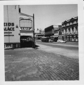
Photograph - Digital image, Chris Phillips, late 1950's?
... in Lydiard St North with the various buildings on the west side... in Lydiard St North with the various buildings on the west side ...Yields information about the tram operations in Lydiard St North during the 1950's and the appearance of the buildings.Digital image, black and white, of a bogie tram north bound in Lydiard St North with the various buildings on the west side of the street - 1950's photo, prior to the installation of the lights on the tramcars. Has Reid's Coffee Palace in the photograph. Taken from the Railway Station entry.trams, tramways, lydiard st north, tram 13 -
 Linton and District Historical Society Inc
Photograph, Streetscape, Sussex Street, Linton, Railway Hotel, James Nelson Undertaker, Linton Public Library
... no. 338) which shows both east and west sides of Sussex Street... both east and west sides of Sussex Street. The photograph has ...Photograph taken after 1901 as James Nelson took over his family's undertaker's business in that year.This is a cropped version of a photograph (Registration no. 338) which shows both east and west sides of Sussex Street. The photograph has been mounted on card (for use at LDHS exhibition, 1983). This version of the photograph (showing Sussex St east side) is also Mounted photo 444.sussex street linton, railway hotel linton, james nelson undertaker, linton public library -
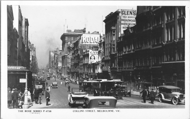 Melbourne Tram Museum
Postcard, Rose Stereograph Co, "Collins Street Melbourne", c1928
... Melbourne", looking west from Swanston Street. Has several cable...", looking west from Swanston Street. Has several cable trams ...Rose Series postcard No. P 4738, titled "Collins Street Melbourne", looking west from Swanston Street. Has several cable trams in the view, the nearest one having a destination of "Victoria Bridge". There are adverts for Kodak, and "Listen in Radios". A "Tramway Inspector?" is standing in the safety zone. The Collins Street cable trams were closed in 1929.Yields information about Collins St c1928Postcard - printed real photograph with Rose Stereograph Co. name on the rear.Has the Ken Magor stamp on the rear.trams, tramways, cable trams, collins st -
 Tatura Irrigation & Wartime Camps Museum
Photograph, Collivers Shop, 2001
... Colliver's cafe located north side of Hogan Street just... Street just west of railway crossing. Photo 2 c.1970. Photo 3 ...Colliver's cafe located north side of Hogan Street just west of railway crossing. Photo 2 c.1970. Photo 3 1984 just prior to demolition. Four photos.Photos 1 & 4 taken in 1950hogan street, colliver, photograph, buildings -
 Stawell Historical Society Inc
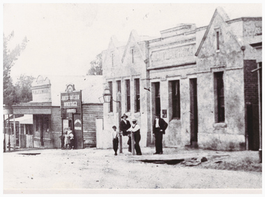
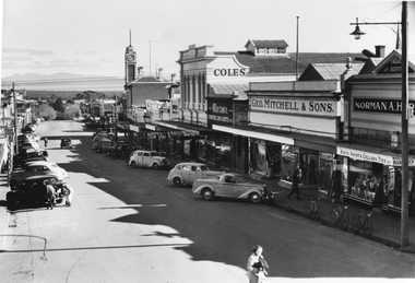
Photograph, Main Street Stawell looking West
... Main Street Stawell looking West...B/W Main Street looking West. Vehicles angle parked... grampians B/W Main Street looking West. Vehicles angle parked ...B/W Main Street looking West. Vehicles angle parked in street. Brick Bull and Mouth Hotel and Dane Bros Wine Spirits Store on left. Coles. George Mitchell & Sons and Norman Harding on right.stawell businesses streetscape -
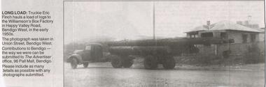 Bendigo Historical Society Inc.
Newspaper - JENNY FOLEY COLLECTION: LONG LOAD
... to the Williamson's Box factory in Happy Valley Road, Bendigo West.... This photograph was taken in Union Street, Bendigo West. Newspaper JENNY ...Bendigo Advertiser "The way we were" from Monday, February 7, 2005. Long load: truckie Eric Finch hauls a load of logs to the Williamson's Box factory in Happy Valley Road, Bendigo West, in the early 1950s. This photograph was taken in Union Street, Bendigo West.newspaper, bendigo advertiser, the way we were -
Stawell Historical Society Inc
Photograph, Aerial Photos of Stawell from a Hot Air Balloon 1992 -- 12 Photos
... . Gold Reef Mall looking West 8. Church Street looking West 9... looking West 8. Church Street looking West 9. Looking towards ...Series of 12 Aerial Photos of Stawell. Hot Air Balloon, October 1992 1. Cnr. Maude St & Grant Street 2. Maude St Napier Street & Railway cutting 3. Trotting Track 4. Roundabout Wimmera & Sloane Street 5. Florence Street towards Cato Lake & Park 6. Grampians Range with Lake Lonsdale near center 7. Gold Reef Mall looking West 8. Church Street looking West 9. Looking towards Black Range 10. Moonie Dams Darlington Road Leisure Complex 11. Stawell Gold Mine Evaporations Dams, Stawell Water Reservoirs, Moonie Dams 12. Darlington Road looking towards Black RangeSeries of 12 colour photographs from the Air.stawell -
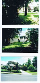 Greensborough Historical Society
Photograph - Photographs, 104 Nell Street Greensborough, c1990
... : "This was the original house at 104 Nell Street Greensborough. Just west of Henry... Street Greensborough. Just west of Henry Street the house ...Photographs of 104 Nell St Greensborough c 1990. Caption: "This was the original house at 104 Nell Street Greensborough. Just west of Henry Street the house was demolished and a new brick home was built by Craig and Diane Herman, descendants of original home owners. Craig and Diane and kids have been GHS members and are local to cricket and footy umpiring."3 Colour Photographs with captionnell street greensborough, greensborough houses, herman family -
 Phillip Island and District Historical Society Inc.
Book, Minutes of the Phillip Island Co-Operative Society Limited 1947-1950
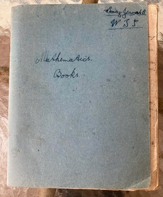
... Bain on the south west corner of Chapel Street and Thompson Ave... the store of Mr Roy Bain on the south west corner of Chapel Street ...A group of farming families purchased the store of Mr Roy Bain on the south west corner of Chapel Street and Thompson Ave, Cowes for the Co-Op store. It began as stocking farming equipment but later had general grocery items.Pale blue exercise book containing hand written minutes of the Co-Operative Society, includes lists of shareholders.Annual and committee meetings held. Cover - Mathematics book, Nancy Jenner W.T.S.phillip island co-op store, roy bain, f. b. morgan-payler, farming -
 Ballarat Tramway Museum
Photograph - Copy - Black & White - Sturt and Grenville Streets Ballarat, 1920s
... and Grenville Street looking west along Sturt St, shows three trams... on the corner of Sturt and Grenville Street looking west along Sturt St ...Photo taken from the store on the corner of Sturt and Grenville Street looking west along Sturt St, shows three trams at the terminus, including the large waiting room shelter. Shows the buildings along Sturt St with few pedestrians. Yields information about the view from Grenville St looking west along Sturt St BallaratCopy Photograph - Black & White - Sturt and Grenville Streets Ballarat Details the image on the rear of the print in ink. "Ballarat - Sturt St, westwards from Grenville St with trams at the City terminus. Note: Large old waiting room on roadway. Tram Nos Left 5 or 6? right - 13? Copy neg Mark Plummer collections ex late John Alfred collection. ballarat, grenville st, shelters, sturt st, esco, tram 13, tram 5 -
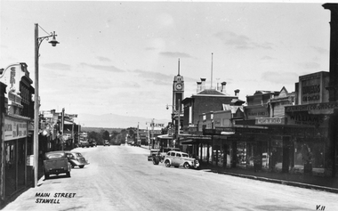
 Stawell Historical Society Inc
Photograph, Main Street Stawell looking West 1950's
... Main Street Stawell looking West 1950's...B/W Main Street looking West. Taken from Bull and Mouth... grampians B/W Main Street looking West. Taken from Bull and Mouth ...B/W Main Street looking West. Taken from Bull and Mouth Hotel verandah. Vehicles angle parked in street. Town Hall clock tower Coles. George Mitchell & Sons and Norman A Harding on right. 1950'sstawell businesses streetscape -
 Stawell Historical Society Inc
Photograph, Main Street Stawell looking West c1940's
... Main Street Stawell looking West c1940's...B/W Main Street looking West. Taken from in front of Dane... grampians B/W Main Street looking West. Taken from in front of Dane ...B/W Main Street looking West. Taken from in front of Dane Bros Spirits Bull and Mouth Hotel verandah. Vehicles angle parked in street. Town Hall clock tower Post Office visible. 1940'sstawell businesses -
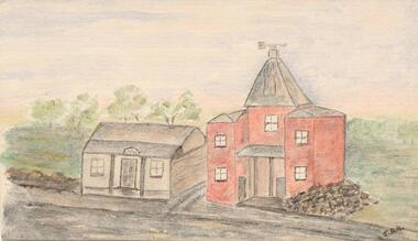
![Plan, Improvements on the Camp Reserve Ballarat, 1870, 26/4/1870 (exact); Traced by Henry [Mornes?], district surveyor, on the above date](/media/collectors/4f729f6797f83e0308601707/items/4f72a4fa97f83e0308602508/item-media/59b79d3921ea680200c6b8a7/item-fit-380x285.jpg) Federation University Historical Collection
Federation University Historical CollectionPlan, Improvements on the Camp Reserve Ballarat, 1870, 26/4/1870 (exact); Traced by Henry [Mornes?], district surveyor, on the above date
... shown in on the west side of Camp Street is now used... shown in on the west side of Camp Street is now used ...The Ballarat Camp housed the Goldfields administrators. It was from this site that the troopers left on the morning of 3 December 1854 to attack the Eureka Stockade. Much of the area shown in on the west side of Camp Street is now used by the Federation University Arts Academy.Hand-drawn plan on white linen showing the camp reserve in what is now known Ballarat's Camp Street. The plan shows allotments in an area bounded by Mair, Sturt and Lydiard Streets. The plan has colours indicating wooden buildings, stone buildings, brick buildings, Wood & zinc buildings, and wood & brick buildings.ballarat, camp street, horace walker, henry mornes, goldfields architecture, reserve for public, buildings, goldfields administration, eureka stockade -
Port Melbourne Historical & Preservation Society
Photograph - Port Melbourne, Pat Grainger, 1996
... of the 1910 post office .04 View north of Bay Street footpath, west... Street footpath, west side Photograph Port Melbourne Pat Grainger ...Four panoramic black&white photos taken c1996 .01 View toward city of Nott Street and the school .02 View toward city of Nott Street, vertical .03 Pedestrian crossing in front of the 1910 post office .04 View north of Bay Street footpath, west sidebuilt environment, nott street, bay street -
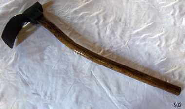 Flagstaff Hill Maritime Museum and Village
Tool - Adze, Ward & Payne Ltd, Between 1843 to Mid 20th Century
... as the "Limerick Wheel". For a time Wards operated from both 106-114 West...". For a time Wards operated from both 106-114 West Street Sheffield ...An adze is an ancient and versatile cutting tool and has been in use for thousands of years. Adze are similar to an axe but with the cutting edge perpendicular to the handle rather than parallel. They have been used since the Stone Age. Adzes are hand tools used for smoothing or carving wood. The subject item was made by Ward & Payne of the Limbrick Works at Hillsborough, Sheffield England manufacturers of hand-forged tools. Their trademark registered in 1850 was a Letter "W" & "P" stamped into the steel. The firm was established by David Ward (1767-1822) in 1803 the company became David Ward & Sons, in 1837 after Ward's son Edward joined the firm. In 1845 Henry Payne the founder's son-in-law became a partner but died in 1850 after which the company reverted to the Ward family. The business then concentrated on making carving tools, chisels and gouges. In 1882 David Ward's grandson David Ward Jr. (1835-1889) purchased land and built a factory at Sheffield North known as the "Limerick Wheel". For a time Wards operated from both 106-114 West Street Sheffield and at Limbrick Road, Hillsborough on the river Loxley. By 1911 they had expanded into making spades, forks, sheep shears and many other types of edged tools including drills and wood planes. In 1967 Wilkinson Sword purchased all the company's share capital and continued to sell Ward & Payne tools until 1970 when a fire burned the factory down and housing development was built on the site.The subject item is significant as it gives a snapshot of the technological development of sailing ships and their operation before steam-powered vessels took over around the world. Tools such as the subject item demonstrate the traditional craftsmanship and skill of the shipwright and the aesthetic quality of the timber ships designs of the time. Adze with wooden handle curved painted green with patent number and maker's name inscribed on inside curve of blade. Inscribed "Patd 561 Ward" "2w". flagstaff hill, warrnambool, flagstaff-hill, flagstaff-hill-maritime-museum, maritime-museum, shipwreck-coast, flagstaff-hill-maritime-village, smoothing tool, hand tool, carpenders tool, adze, coopers tool, woodworking tools -
 Stawell Historical Society Inc
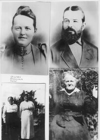
Photograph, Shamrock Hotel Stawell West Owners -- Clockwise -- top left Mrs Agnes Jenkins nee Keegan, Mr William John Jenkins, Mrs Agnes Jenkins nee Keegan, & Mrs Agnes Jenkins nee Keegan on left
... Street and Longfield Streets Stawell West. Clockwise from top... Street and Longfield Streets Stawell West. Clockwise from top ...Four photos of owners of Shamrock Hotel corner of Seaby Street and Longfield Streets Stawell West. Clockwise from top left Agnes Jenkins nee Keegan. William John Jenkins. Agnes Jenkins nee Keegan. Agnes Jenkins nee Keegan on left Four Photos of people. Woman, man, two ladies and older lady Owners of Shamrock Hotel stawell business -
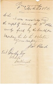 Bendigo Historical Society Inc.
Document - CONNELLY, TATCHELL, DUNLOP COLLECTION: LEGAL PAPERS, 1886
... Bennett, Attenborough, Wilks & Nunn, 102 Collins Street West..., 102 Collins Street West, Melbourne re Webb v Holmes White & Co ...Documents. Connelly, Tatchell & Dunlop - Legal Papers. 1 - 1886 - Letter from Malleson, England & Stewart, 24 Queen Street, Melbourne re Dr Brierley. 2 - 1886 - Letter from Reid Jas, Raywood re his arrest on the 2nd Oct and fine on the 4th Oct. 3 - 1886 - Letter from Gibbins Alice, Inglewood. 4 - 1886 - Letter from Morrow Thomas, General Mercantile, Auctioneer, Stock Station & Estate Salesman, Inglewood re Gibbins. 5 - 1886 - Post Office Telegraph from Harrison J S & Co. 6 - 1886 - Letter from Bennett, Attenborough, Wilks & Nunn, 102 Collins Street West, Melbourne re Webb v Holmes White & Co. 7 - 1886 - Letter from Bennett, Attenborough, Wilks & Nunn, 102 Collins Street West, Melbourne re Sterry v Trestrail. 8 - 1886 - Post Office Telegraph from Blackburn Jas, Heathcote, re case at Heathcote.cottage, miners, connelly, tatchell & dunlop, malleson, england & stewart, brierley dr, reid jas, gibbins alice, morrow thomas, gibbins, harrison j s & co, bennett attenborough wilks & nunn, webb, holmes white & co, sterry, trestrail, blackburn jas -
 Ringwood and District Historical Society
Newspaper, Newspaper articles detailing the acquisition of 40 acres of land for Jubilee Park, formerly known as Sanders Estate, for recreation purposes
... . The area included named streets - Prussia Road (not West Prussia... - Prussia Road (not West Prussia Road), Duffy Street, Ireland Street ...Various newspaper articles about detals of the acquisition, by Ringwood Council, of 40 acres of land for Jubilee Park, formerly known as Sanders Estate, for recreation purposes in 1945-1959. The area included named streets - Prussia Road (not West Prussia Road), Duffy Street, Ireland Street, Evens Street and Chapman Street. -
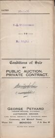 Bendigo Historical Society Inc.
Document - H.A. & S.R. WILKINSON COLLECTION: CONDITION OF SALE
... . A. Wilkinson and R. Rigby for land situate in Elizabeth Street, Nyah.... Rigby for land situate in Elizabeth Street, Nyah West described ...Conditions of sale dated 20th February, 1926 between H. A. Wilkinson and R. Rigby for land situate in Elizabeth Street, Nyah West described in certificate of title Volume 4642 Folio 928297 together with 4-roomed weatherboard dwelling at present occupied by H. W. McDonald as tenant for the price of 500 pounds.organization, business, h.a. & s.r wilkinson real estate -
 Charlton Golden Grains Museum Inc
Photograph, Charlton Presbyterian Church c. 1910, c.Dec 1934
... and Manse. High Street Charlton west end.... and Manse. High Street Charlton west end. Charlton Presbyterian ...The Charlton Presbyterian Church was built in 1871 by James Patterson, a contractor and grazier of Nardoo Park, Woosang. Photo was taken after cyclone which hit Charlton in 18th December 1934. Trees have fallen over the white picket fence in front. Broken tree limbs lie and the nature strip. Buildings from the left, Dew's Bakery, Presbyterian Hall, Church and Manse. High Street Charlton west end.charlton presbyterian church, james patterson, church, presbyterian, pastoral care, storm -
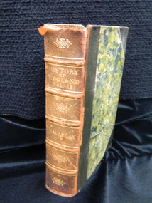 Ballarat Clarendon College
Book, The history of England: from the accession of James the Second, 1889
... . Ilma became Mrs J Bailey of Sturt Street West. From the date.... Ilma became Mrs J Bailey of Sturt Street West. From the date ...Leila Jessie Webb entered Clarendon Ladies' College 1887. Parent/Guardian Edward Webb, Banker, L C Bank Lydiard Street, Ballarat. her sister Ilma Barclay Webb enrolled on the same day. Ilma became Mrs J Bailey of Sturt Street West. From the date of this prize we can infer that Leila attended CLC from 1887 to 1890 and possibly longer. Vol II of II. Popular edition published1889 (first edition 1864). Place/ Publisher- Longman, Green, Longman, Roberts & Green, London. Book in English language. Marbled boards, with matching marbled page edges and marbled endpapers; leather spine and cover; Corners with contrasting colour spine label and gilt lettering. Book plate inside front cover.Book plate: Clarendon Ladies' College / BALLARAT / Second Prize / Botany Class I / AWARDED TO / Leila Jessie Webb / R Kennedy / Principal / December 1890leila-jessie-webb, clarendon-ladies-college, ilma-barclay-webb, 1890 -
 Phillip Island and District Historical Society Inc.
Photograph - Post Card, Cowes School Back to 1926 Chapel Street, March 1926
... , driving along Chapel Street going west on unmade road. Land... cars , decorated with streamers, driving along Chapel Street ...Donated by Stan McFee from the Keith McIlwraith CollectionSepia postcard of four cars , decorated with streamers, driving along Chapel Street going west on unmade road. Land on left was owned by Methodist Church, corner of Chapel and Bass Ave., where large tree denotes the boundary. Finley? Forrest's house on right. Coming to Back to Cowes School Celebration March 1926On back: "Back to Cowes March 1926"celebrations - back to cowes school phillip island, decorated cars, phillip island, stan mcfee, keith mcilwraith collection -
 Phillip Island and District Historical Society Inc.
Water colour Sketch, 1960's
... West situated in Main Street, Cowes. First Chicory Kiln built...", in 1889. Chicory Kiln built for John West situated in Main Street ...The first kiln built on Phillip Island in the 1870's for Mr John West. It was situated in Thompson Avenue next to Wests General Store. When the kiln was demolished, the bricks were used to build the old Post Office on the corner of the Esplanade. Mr John West gave a Banquet at the Isle of Wight Hotel to celebrate the opening of his kiln.Water Colour Sketch. This picture was reconstructed by Jean Archibald from pencil sketches by S Serpell in 1905, and an artist who travelled to Phillip Island with the "Vagabond", a journalist for the "Leader", in 1889. Chicory Kiln built for John West situated in Main Street, Cowes. First Chicory Kiln built on Phillip Island in the 1870's.Signed J. D. A.local history, illustrations, agriculture buildings, historic, chicory kiln, water colour sketch, west family, post office cowes phillip island, jean archibald, s serpell, john west, n & j archibald -
Glenelg Shire Council Cultural Collection
Photograph - Photograph - Percy Street, Portland, 1970s
... shows west side of Percy Street between Henty and Tyers Streets... Cliff Street Portland great-ocean-road Portland street scene ...Photographic print of a rephotographed photograph. Image shows west side of Percy Street between Henty and Tyers Streets. Four single story buildings (one behind wooden fence) facing street. Robertson Store - 2 storey, round roof, far right of photo. Several people and horses and carts in street (unmade).Front: 'Robertson Store' - green inkportland street scene, percy street -
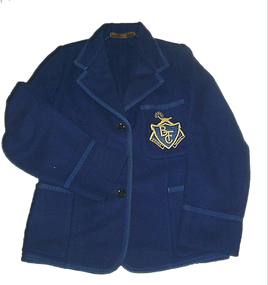 Federation University Historical Collection
Costume, Ballarat Teacher's College Blazer, c1948
... at Wendouree West, Wendouree, Urquhart Street and Pleasant Street... at the Ballarat Teachers' College in Dana Street. She lived in Ascot ...This blazer was worn by Helen Veitch in 1948, while a student at the Ballarat Teachers' College in Dana Street. She lived in Ascot Street South and attended the Urquhart Street Primary School. The first class she taught was grades 1&2 at Wedderburn Primary School with 46 students. She also taught at Wendouree West, Wendouree, Urquhart Street and Pleasant Street Primary Schools. She married in 1955 and died in 1979.This royal blue woollen, unlined blazer is bound on all the edges with braid including the tops of the three pockets and 8.5cm from the sleeve edge. The embroidered patch breast pocket has the emblem of the Ballarat Teachers College. It has three buttons at the front. Most of the seams are bound, though some are turned back and stitched down. The back of the top of the pockets are reinforced with cotton fabric.Maker's embroidered patch - Paterson, Powell Pty Ltd, Ballarat White tape with handwritten marking - Veitchblazer, helen veitch, costume, textiles, logo, embroidery -
 Melbourne Tram Museum
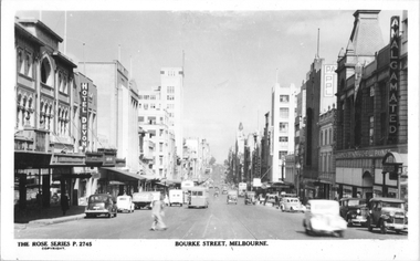
Postcard, Rose Stereograph Co, "Bourke St, Melbourne", late 1940s
... Streets looking west, with two double deck buses and one single... taken from between Exhibition and Russell Streets looking west ...Rose Series postcard No. P 2745, titled "Bourke St, Melbourne". Photo taken from between Exhibition and Russell Streets looking west, with two double deck buses and one single deck bus in the view. The cable tram track remains in position. Photo late 1940s.Yields information about the eastern end of Bourke St in the late 1940s.Postcard - printed real photograph with Rose Stereograph Co. name on the rear.tramways, trams, bourke st, buses, mmtb buses -
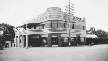 Ringwood and District Historical Society
Photograph, Coach and Horses Hotel, Ringwood circa 1940
... in Maroondah Highway, west of New Street, now adjacent to Eastlink... in Maroondah Highway, west of New Street, now adjacent to Eastlink ...Black and white photograph of Coach and Horses Hotel in Maroondah Highway, west of New Street, now adjacent to Eastlink Freeway, on northern side. There are two duplicate photos. Certainly the photo was taken post-1940 as the previous Coach & Horses Hotel, on the south side, burnt down in 1940. The telephone pole indicates that era, with limited lines. The style of the building was Art Deco that generally existed in the 1920s-1930s but did continued in Australia in the 1940s. The building has the appearance of being newly-built. Was H4, in the old cataloguing system. -
 Kew Historical Society Inc
Map, MMBW, MMBW Plan No.66 Kew, 1900-1910
... of Kew, bordered on its north by Adeney Avenue, in the west... Avenue, in the west by Sackville Street, in the south by Barkers ...The Melbourne and Metropolitan Board of Works (MMBW) was established by an act of the Victorian Parliament in 1890 to prepare for and to implement a sewerage and water reticulation system across what was then inner Melbourne, its surrounding and middle distance suburbs, including Kew. The MMBW was disbanded in 1991.The map collection of the Kew Historical Society has at its core the historic maps assembled and originally stored in the City Engineer's Department of the City of Kew. These include maps in a number of scales. The vast majority of maps were produced by the MMBW in the first two decades of the twentieth century, and are solid working maps, backed by linen for durability. These maps are historically significant to Kew, the City of Boroondara and to the history of the development of state utilities in Victoria. A number of the Kew maps have additional details added by former municipal officers, including the levels reached by various floods. As these were working documents, information was added to them long after the period of their initial production and distribution.Early map of part of the Borough of Kew, created in the first decade of the twentieth century, at a scale 160 ft to 1 inch. The map covers what was then the south eastern part of Kew, bordered on its north by Adeney Avenue, in the west by Sackville Street, in the south by Barkers Road, and in the east by Burke Road. The map shows the extent of urban development by that time, prominent institutions and the outlines of built structures in the municipality. Contour lines were added in ink to the map at a later stage.MELBOURNE AND METROPOLITAN BOARD OF WORKS / PLAN NO. 66 / KEW melbourne & metropolitan board of works, mmbw maps, mmbw plans, borough of kew, cartography