Showing 11840 items
matching ringwood
-
 Ringwood and District Historical Society
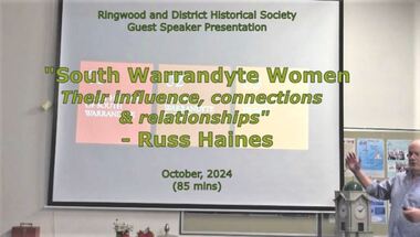
Mixed media - Video, RDHS Meeting Presentation - "South Warrandyte Women - their influence connections & relationships" - Russ Haines
Digitised video (4.64GB). Duration: 85 minutes. Recorded October, 2024 (Video is available for viewing at Ringwood & District Historical Society Archives by appointment)In this presentation, Ringwood and District Historical Society President Russ Haines introduces a brief history of the South Warrandyte area and focuses on the community spirit and collective support amongst women of the district. -
 Ringwood and District Historical Society
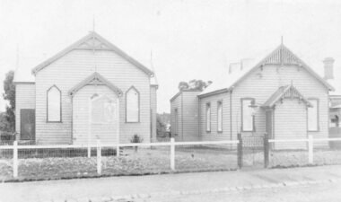
Photograph, Ringwood Methodist Church on site at Cnr. Melbourne St. and Whitehorse Rd 1904
Written on backing sheet, "Methodist Church on site at Cnr. Melbourne St. and Whitehorse Rd. On its removal to Greenwood Ave. Mr. J.B. McAlpin built shops on this site - land (Dimmey's) including his own estate agency." One photograph claimed church was moved to Greenwood Ave in 1916. Photograph taken in 1904. Another photograph states that the photograph is of the Methodist Church and Sunday School. Inserted in the sleeve of one of the photographs are two small postcard photographs that state they are, "Methodist Church in Main Street, Ringwood opposite railway station. See Mechanics Institute where Town Hall now stands - c1910. Photo by L. F. East". -
 Ringwood and District Historical Society
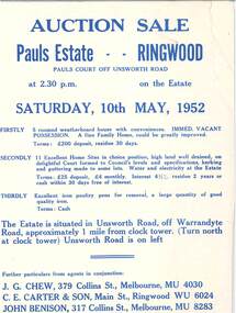
Flyer - Auction Sale, Pauls Estate Subdivision, Pauls Court off Unsworth Road, Ringwood, Victoria - 1952
Double-sided page advertising auction on Saturday, 10th May, 1952 in 3 parts. "Firstly - 5 roomed weatherboard house with conveniences. Immediate vacant possession. ... Terms: £200 deposit, residue 30 days". "Secondly - 11 excellent home sites. ... Terms: £25 deposit, £4 monthly. Interest 4-1/2%, residue 2 years or cash within 30 days free of interest". "Thirdly - Excellent iron poultry pens for removal, a large quantity of good quality iron. Terms: Cash". Agents in conjunction: J.G. Chew, 379 Collins Street, Melbourne, (phone) MU4030, C.E. Carter & Son, Main Street, Ringwood, (phone) WU6024, John Benison, 317 Collins Street, Melbourne, (phone) MU8283. -
 Ringwood and District Historical Society
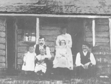
Photograph, Britten Family and home. Warrandyte Road, Ringwood. c1907
Black and white photograph of family group at rear of house. (2 copies- 1 large, 1 small). Small copy mounted on cardboard backing.Typed under large photograph, "Britten Family and home (site became Church of England, Warrandyte Road). Note log walls and rain-water barrel at this pioneer home. c 1907." Written on rear of small photograph: "Wm Grace (1876), James Claridge (1880s) C.G. Britten (1905). All occupied this cottage on site now Church of England vicarage, Warrandyte Rd. Ringwood. Group from left. C.G. Britten holding daughter (Muriel) with son (Reg) on his right. His wife (nee Ethel Banks, Claridges' granddaughter) at rear with her sister in front, and brother Wally on extreme right. (Back of house)." -
 Whitehorse Historical Society Inc.
Map, Nunawading Shire, 1892
Photocopy of an enlargement of map of Shire of Nunawading showing landowners in 1892.Photocopy of an enlargement of map of Shire of Nunawading showing landowners in 1892. Covers Middleborough Road to Ringwood boundary. One map (Blackburn) from north of Whitehorse Road to Highbury Road, 2nd map (Mitcham) Bulleen to south of Canterbury Road; 3rd map Whitehorse Road to Highbury Road.Photocopy of an enlargement of map of Shire of Nunawading showing landowners in 1892. maps, shire of nunawading, blackburn, blackburn south, nunawading, forest hill, vermont, mitcham, vermont south -
 Ringwood and District Historical Society
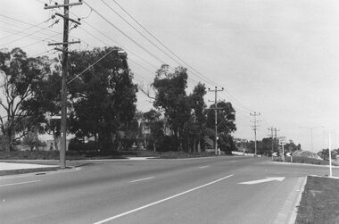
Photograph, Maroondah Highway East, Ringwood- 1969. Looking west towards Ringwood from Everard Road
Black and white photographWritten on back of photograph: "Site of Cass's school, 1874. (1 acre left out of 5 acres). -
 Ringwood and District Historical Society
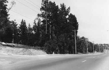
Photograph, Maroondah Highway East, Ringwood- 1969. Looking west towards Ringwood from Braeside Ave corner
Black and white photographWritten on back of photograph: "Nov 1969, cnr of Braeside Ave and Maroondah Highway." -
 Ringwood and District Historical Society
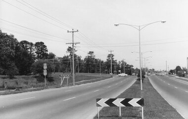
Photograph, Maroondah Highway East, Ringwood- 1969. Looking west towards Ringwood from Mt Dandenong Road intersection
Black and white photographWritten on back of photograph: "Nov 1969, Cnr Mt Dandenong Road and Maroondah Highway." -
 Ringwood and District Historical Society
Photograph, Maroondah Highway East, Ringwood- 1969. Looking west towards Ringwood from Mt Dandenong Road
Black and white photographWritten on back of photograph: "Cnr Maroondah Highway and Mt Dandenong Road. Nov 1969." -
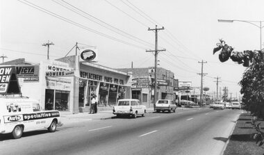 Ringwood and District Historical Society
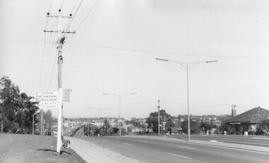
Photograph, Maroondah Highway East, Ringwood- 1969. Looking towards Ringwood from 'Repco' premises
Black and white photographImage shows businesses on south side of Highway, including John Salisbury Mowers, Repco, Maroondah Auto Electrics, Chemist, and Alan Coffey Motors used cars. -
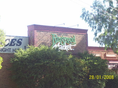 Ringwood and District Historical Society
Photograph, Side wall of former Ringwood Market in January 2008, Bond St, Ringwood
Digital scan -
 Ringwood and District Historical Society
Photograph, Eastern views from 6-10 Ringwood Street, Ringwood up to former Civic Place in 2008
Photographic record by Russ Haines, RDHS, in 2008. -
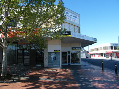 Ringwood and District Historical Society
Photograph, Corner of Civic Place (now a footpath) and Ringwood Street, Ringwood towards the south, in 2008. Showing Ray White real estate and Holt & Macdonald, solicitor
Photographic record by Russ Haines, RDHS, in 2008. -
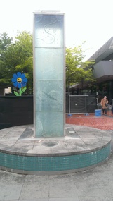
 Ringwood and District Historical Society
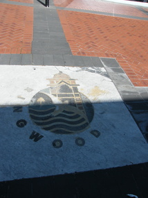
Photograph, City of Ringwood Council logo in Melbourne Street, Ringwood in 2008, with general view of water feaure and library
Photographic record by Russ Haines, RDHS, in 2008. -
 Ringwood and District Historical Society
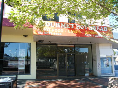
Photograph, No 2 Civic Place, Ringwood in 2008, at the corner of Ringwood Street. Showing gourmet hot bread shop
Photographic record by Russ Haines, RDHS, in 2008. -
 Ringwood and District Historical Society
Photograph, Civic Place, Ringwood in 2008, near the corner of Ringwood Street. Showing Bendigo Bank
Photographic record by Russ Haines, RDHS, in 2008. -
 Ringwood and District Historical Society
Photograph, Looking east, Civic Place, Ringwood in 2008, near the corner of Ringwood Street. Showing WestpacBank and JB Clearance Centre, with Melbourne Street at end
Photographic record by Russ Haines, RDHS, in 2008. -
 Ringwood and District Historical Society
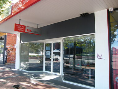
Photograph, Civic Place, Ringwood in 2008, near the corner of Ringwood Street. Showing Westpac Bank's Financial Serices Centre
Photographic record by Russ Haines, RDHS, in 2008. -
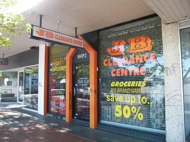 Ringwood and District Historical Society
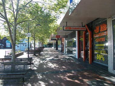
Photograph, Civic Place, Ringwood in 2008, near the corner of Ringwood Street. Showing JB Clearance Centre
Photographic record by Russ Haines, RDHS, in 2008. -
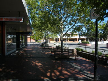 Ringwood and District Historical Society
Photograph, Looking west towards Ringwood Street, in Civic Place, Ringwood in 2008, near to Midway Arcade. Showing JB Clearance Centre and Post Office across the road
Photographic record by Russ Haines, RDHS, in 2008. -
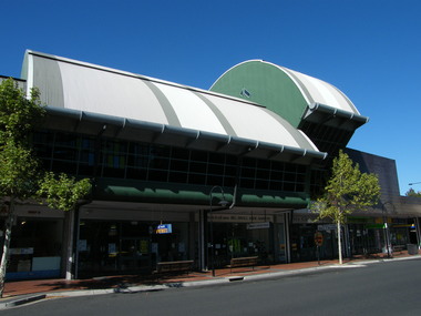
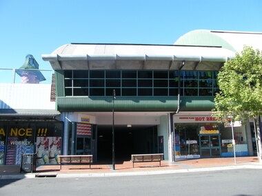 Ringwood and District Historical Society
Photograph, Below Melbourne Street to entrance of Eastland, Ringwood in 2008, showing shops at Ringwood Plaza
Photographic record by Russ Haines, RDHS, in 2008. -
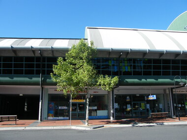 Ringwood and District Historical Society
Photograph, Below Melbourne Street to entrance of Eastland, Ringwood in 2008, showing shops at Ringwood Plaza
Photographic record by Russ Haines, RDHS, in 2008. -
 Ringwood and District Historical Society
Photograph, Below Melbourne Street to entrance of Eastland, Ringwood in 2008, showing shops at Ringwood Plaza
Photographic record by Russ Haines, RDHS, in 2008. -
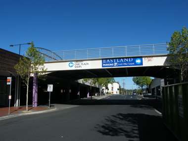 Ringwood and District Historical Society
Photograph, West of entrance to Eastland, Ringwood in 2008, showing car overpass, with Ringwood Street in distance
Photographic record by Russ Haines, RDHS, in 2008. -
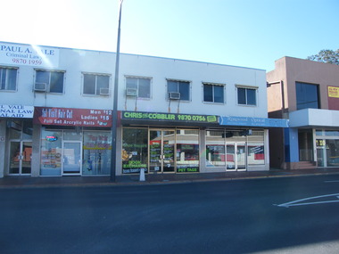
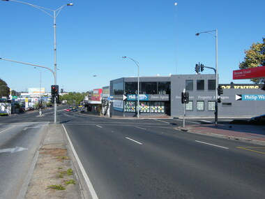 Ringwood and District Historical Society
Photograph, Looking west along Maroondah Highway, Ringwood in 2008, Wantirna Road to the left, Ringwood Street to the right. Philip Webb estate agents, Hocking Stuart, Oz Knits businesses
Photographic record by Russ Haines, RDHS, in 2008. -
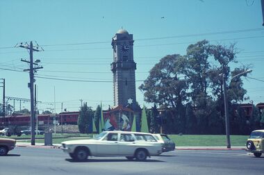
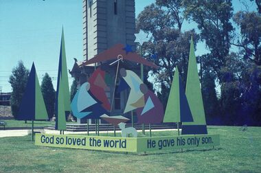 Ringwood and District Historical Society
Photograph, 1978 Christmas decorations at the Ringwood Clocktower, on Maroondah Highway, Ringwood
-
 Ringwood and District Historical Society
Photograph, 1978 Christmas at the Ringwood Clocktower, on Maroondah Highway, Ringwood
-
 Ringwood and District Historical Society
Photograph, Eastland, Ringwood in June 2002, from Warrandyte Road, Ringwood facing west, over the former car park. Showing Safeway (far left) and Myer (right)
Photographic record by Russ Haines, RDHS, in October 2008. -
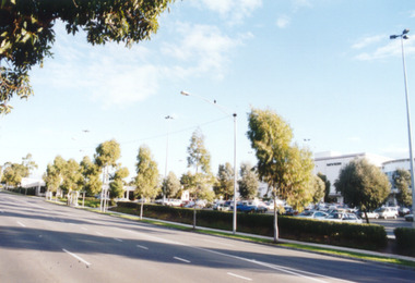
 Ringwood and District Historical Society
Photograph, Water feature in Melbourne Street, Ringwood. Contruction work beginning at the Ringwood Railway Station and Stage 5 of Eastland circa 2014
Photographs taken by Terry Ahern in 2008-2014, member of RDHS -
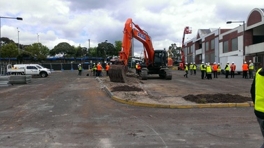 Ringwood and District Historical Society
Photograph, Removal of car park at former Adelaide Street, Ringwood. Preparation for construction work beginning at the Ringwood Railway Station and Stage 5 of Eastland circa 2014
Photographs taken by Terry Ahern in 2008-2014, member of RDHS