Showing 11453 items matching " maps"
-
 Ballarat Heritage Services
Map, Map of Abel Tasman's Voyages, 1642-1644
Copy of a map from 'A Short HIstory of Australia' by Ernest Scott.map, explorers, exploration, abel tasman, voyages -
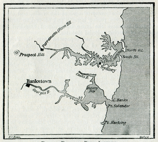 Ballarat Heritage Services
Map, Botany Bay and Port Jackson
Copy of a map from 'A Short HIstory of Australia' by Ernest Scott.map, explorers, exploration, voyages, new south wales coast, port jackson, botany bay bankstown, prospect hill, parramatta, rose hill, sydney -
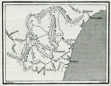 Ballarat Heritage Services
Map, The Blue Mountains, New South Wales
Copy of a map from 'A Short HIstory of Australia' by Ernest Scott.map, explorers, exploration, new south wales coast, parramatta, sydney, gosford, maitland, newcastle, blue mountains, picton -
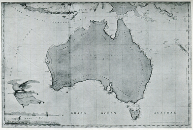 Ballarat Heritage Services
Photograph - Map, Freycinet's Map, Showing 'Terre Napoleon'
Copy of a map from 'A Short History of Australia' by Ernest Scott.map, explorers, exploration, freycinet, terre napoleon, australia -
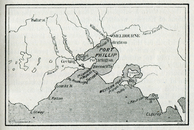 Ballarat Heritage Services
Map, Westernport and Port Phillip
Copy of a map from 'A Short History of Australia' by Ernest Scott.map, explorers, exploration, westernport, port phillip, queenscliffe, melbourne, brighton, williamstown, port arlington, hobson bay, cape otway, geelong, barwon river, ballarat, yarra river, yarra yarra river -
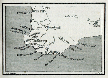 Ballarat Heritage Services
Map, King George's Sound
Copy of a map from 'A Short History of Australia' by Ernest Scott.map, explorers, exploration, king george's sound, perth, fremantle, bunbury, busselton, bridgetown, albany, york, williamsburgh -
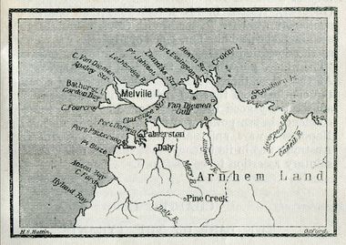 Ballarat Heritage Services
Map, Melville Island
Copy of a map from 'A Short History of Australia' by Ernest Scott.map, explorers, exploration, melville island, tiwi islands, arnhem land, palmerston, daly, croker island, bathurst island, pine creek, daly river -
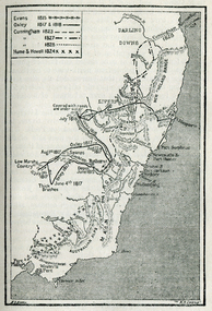 Ballarat Heritage Services
Map, Australian Inland Exploration, 1815-1928, 1815-1828
Copy of a map from 'A Short History of Australia' by Ernest Scott.map, explorers, exploration, australian alps, westernport, port phillip, hume and hovell, oxley, evans, cunningham, darling downs, liverpool -
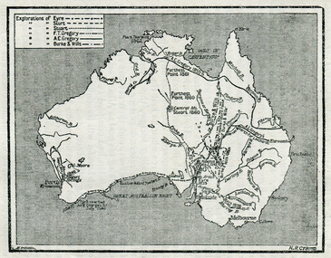 Ballarat Heritage Services
Map, Exploration of Eyre, Sturt, Stuart, Gregory, Burke, and Wills
Copy of a map from 'A Short History of Australia' by Ernest Scott.map, explorers, exploration, burke and wills, sturt, stuart, gregory, melbourne, perth, sydney, mitchell river, a.c. gregory, darling river, lachlan river, mt stuart, murray river -
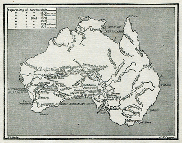 Ballarat Heritage Services
Map, Exploration of Eyre, Sturt, Stuart, Gregory, Burke, and Wills
Copy of a map from 'A Short History of Australia' by Ernest Scott.map, explorers, exploration, stuart, gregory, melbourne, perth, sydney, darling river, murray river, adelaide, albany, fitzroy river, flinders river, brisbane, great australian bight, gulf of carpentaria, mount grey, forrest -
Unions Ballarat
Women and children first : an outline of a population policy for Australia, Wallace, Victor Hugo, 1946
Written in 1946, the author presents ways to encourage population increase in Australia. Relevant to social choices and customs in the 1940s.Paper; book. Front cover: red and white with a map of Australia.Front cover: author and title.btlc, ballarat trades hall, ballarat trades and labour council, birth control, population, social policy, social customs, contraception -
Southern Sherbrooke Historical Society Inc.
Map, "Melway Melbourne Town & Country Wall Map, Municipal Edition 1983", 1983
Wall map showing municipal boundaries prior to 1995 amalgamations.melbourne -
 Ringwood RSL Sub-Branch
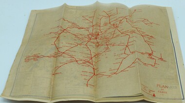
Booklet, Paris map
Map of Paris and info booklet for Englishmen and Americans and toilet guide -
 Ringwood RSL Sub-Branch
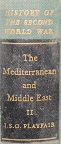
Book - WW2, Mediteranean and Middle East volume 2, 1954
Volume 2 392 pages Maps and black and white prints -
 Running Rabbits Military Museum operated by the Upwey Belgrave RSL Sub Branch
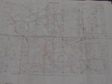
Field Map
Very old, fragile map of Becelaere, Western Front, France.documents, ww1, army -
Running Rabbits Military Museum operated by the Upwey Belgrave RSL Sub Branch
Pilot's Map
Part of survival Kit.Map of Burma, part of Thailand & part of French Indo China.equipment, ww2, raaf -
Stawell Historical Society Inc
Map, Plan Shewing Auriferous Deposits and Reefs (Map of Water Races), c1878
Plan Shewing Auriferous Deposits and Reefs (Map of Water Races)stawell, water -
University of Melbourne, Burnley Campus Archives
Pamphlet (Collection), Pamphlets: Bachelor of Applied Science (Horticulture); Graduate Diploma in Horticulture; Associate Diploma in Horticulture
vcah, burnley college of horticulture, diploma of horticulture, bachelor applied science (horticulture), graduate diplomavcah, burnley college of horticulture, diploma of horticulture, bachelor applied science (horticulture), graduate diploma -
Tarnagulla History Archive
Photocopies of historic maps - Tarnagulla & surrounds, varied
David Gordon Collection. 14 photocopies in clear sleeve. Includes Tarnagulla goldfields maps. -
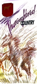 Melton City Libraries
Pamphlet, Thoroughbred Country, c.1985
"Melton has a long and celebrated history of horse breeding and racing. Draught horses were a crucial aspect of life in the early days of European settlement, and were heavily depended upon for both transport and agricultural labour. Peppercorn trees at the corner of Station and Brooklyn roads have been associated with a horse trough installed there to provide a drink to workhorses carting produce to the chaff mills and railway station south of Melton.20 Breeders, trainers and harness drivers in the area later became such an influential force in the equine industry that this came to be a defining aspect of the district’s identity and reputation.Pioneer of the Victorian horse racing industry and early Rockbank squatter William Cross Yuille was one of the earliest importers of stud racehorses in the district in the 1850s. A leading sports editor and writer, Yuille established bloodstock auctioning agency W. C. Yuille & Co. and was involved in the compilation of the first Australian Stud Book, which ensures the integrity of thoroughbred breeding in Australia. According to early Melton chronicler Alexander Cameron, horse races were first organised in the area by Rockbank farmer William Keating. Keating owned racehorses of his own, and many brought horses from Melbourne for the events, which ‘drew large gatherings’.22 Melton Racing Club meetings were held on the Exford Estate with the permission of H. W. Staughton, who built a small wooden grandstand in 1882. Other early races and sports meetings are said to have been held in the vicinity of the current-day Melton golf course.23 An 1884 article reported that Melton’s ‘race programme … equals any put forth by country towns of far greater size’. Ernest Clarke was another important figure in the early horse racing industry in Melton. He established the Melton Stud in 1902, which bred numerous successful racehorses. Perhaps most notably The Welkin, one of the most famous stallions in Australian horse racing in the early twentieth century. The Welkin sired Gloaming, bred by Clarke at the Melton stud in 1915 and one of Australia’s greatest champion racehorses. During a long and prestigious career in both Australia and New Zealand, Gloaming achieved a triumphant 57 wins out of 67 starts and won a record amount of prize money. Ken Cox purchased the Stockwell Stud in Diggers Rest in 1957 and developed it into one of the largest and most renowned thoroughbred breeders in Australia. With its top-class facilities, international design standards and scientific methods, Stockwell became ‘the flagship of the Victorian breeding industry’.26 As well as racing studs, numerous trotting tracks were established on the flat plains around Melton in the 1960s.27 Other studs to play a leading role in the development of Melton as thoroughbred country were Cornwall Park and Merrywood at Toolern Vale, St John’s Lane Stud at Diggers Rest and Birchwood, Teppo Park and Dreelburn in the far north-east of the shire, near Sunbury. By 1985, thoroughbred horse breeding was such big business in Melton that the shire council adopted the slogan ‘The Heart of Thoroughbred Country’, which was used throughout its promotional material.29 But the slogan contained deeper meaning and was not just about Melton’s great equine industry and thoroughbred champions, the council explained: ‘“Thoroughbred Country” should be seen as a new concept of Melton, as a place where people can achieve the “Thoroughbred” ideal, excellence in all aspects of life’. The aim of the council in promoting ‘The Heart of Thoroughbred Country’, was ‘to instil in present and future residents the feeling that this is a place that is better than others. A place to be proud of’. In 1988, Melton’s champion reinsman Gavin Lang won his 176th race of the season, claiming the national harness racing record for the most wins in a single season.The following year, the first Melton Plate was held at Moonee Valley Racecourse, cementing the district’s importance in the harness racing industry. The inaugural winner was Victorys Phil, owned by local Danny Mullan. By the 1990s, Melton had earned the title of the ‘Home of Harness Racing in Victoria’. State-of-the-art, world-class harness racing facility and entertainment complex Tabcorp Park opened in Melton in 2009. In 2011, the Shire of Melton was home to over 140 registered trainers and over 1,200 horses. The municipality’s continuing leadership and influence in the industry today is a testament to the skills, talents and leadership of the local community over its history".Shire of Melton pamphlet of a map and information of the equine industry in Meltoncouncil -
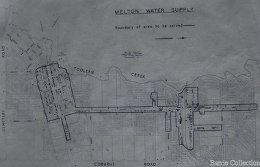 Melton City Libraries
Map, Melton Water Supply, Unknown
The development that had arguably the greatest impact in encouraging population growth in the shire during this period, was the establishment of a reliable water supply for the district. This had been a major concern of the local community for over 100 years, since the Melton township was first founded. Despite various schemes over the years to create a reliable water supply, the district was still dependent on bores, wells and tanks when the Melton Waterworks Trust was established in 1961 to address Melton’s water woes. With the opening of the Djerriwarrh Dam in December 1963, the shire’s residents finally had access to a reticulated water supply.Map shows the boundary of the area where the water will be serviced in the towncouncil -
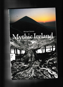 The Celtic Club
Book, Michael Dames, Mythic Ireland, 1992
Ireland, more than any other country in Europe, has retained its mythological heritage, which lives today in the oral tradition of folk tales, in literature, in place-names and language, in ceremonies and monuments. Mountains and loughs are the homes of gods and goddesses, of saints and monsters, and pattern, beauty and cyclical logic are revealed in their stories. Michael Dames, whose previous works have won him a wide and enthusiastic following, has walked through each.Index, bib,notes, maps, plates, ill, p.258.non-fictionIreland, more than any other country in Europe, has retained its mythological heritage, which lives today in the oral tradition of folk tales, in literature, in place-names and language, in ceremonies and monuments. Mountains and loughs are the homes of gods and goddesses, of saints and monsters, and pattern, beauty and cyclical logic are revealed in their stories. Michael Dames, whose previous works have won him a wide and enthusiastic following, has walked through each.1. spirituality, 2. irish myths. -
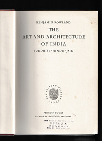 Mrs Aeneas Gunn Memorial Library
Book, Penguin Books, The art and architecture of India : Buddhist, Hindu, Jain, 1953
The art and architecture of IndiaIndex, ill, p.288., 190p. of plates, 1 mapnon-fictionThe art and architecture of Indiaart - india, architecture - india -
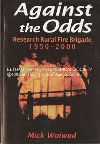 Eltham District Historical Society Inc
Book, Mick Woiwod, Against the Odds; Research Rural Fire Brigade 1950-2000, c.2001
A history of the brigade's first 50 yearsbushfire, eltham barrel, research fire brigade, victorian bushfires - 1969 -
 Bendigo Historical Society Inc.
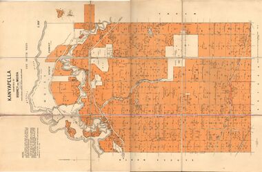
Map - JACK FLYNN COLLECTION: KANYAPELLA, 22/05/1939
Map: Parish of Kanyapella, Counties of Rodney and Moira. Parish plan.By Authority, T. Rider Acting Govt, Printer Melbourne. Drawn and Reproduced at the Dept. of Lands and Survey, Melbourne, Victoria.map, moira, parish plan, kanyapella, counties of rodney and moira -
 Bendigo Historical Society Inc.
Map - EAGLEHAWK, Circa 1870's
Map: Eaglehawk, Compilation of 2 parish plans covering Eaglehawkmap, bendigo, parish plan, eaglehawk -
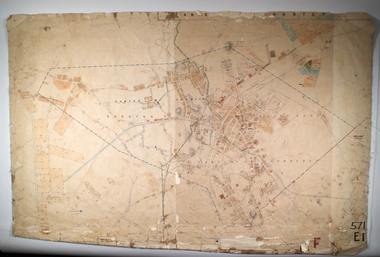
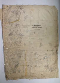 Bendigo Historical Society Inc.
Map - SANDHURST SHEET 1, 27/05/1925
Map: Sandhurst ,County of Bendigo, sheet 1. Parish planmap, bendigo, parish plan, sandhurst -
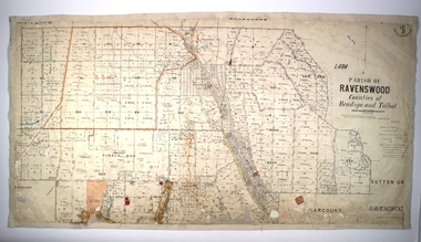 Bendigo Historical Society Inc.
Map - PARISH OF RAVENSWOOD, Circa 1908
Map: Parish of Ravenswood, Counties of Bendigo and Talbot. Parish planmap, bendigo, parish plan, ravenswood, county of talbot -
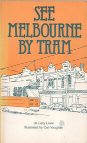 Ballarat Tramway Museum
Book, de Lacy Lowe et al, "See Melbourne by Tram", 1982
Book titled "See Melbourne by Tram" written by de Lacy Lowe, illustrated by Ceri Vaughan, published 1982. Gives a description of 22 Melbourne tram routes with a stop description (not all stops covered) and sketches associated with the location. Has an index in the rear pages.Yields information about Melbourne Trams, their routes and what to see in 1982.Book - 160 pages + card cover with maps on inside covers.Has a handwritten gift notation of 1982 on page 2.trams, tramways, melbourne, tram routes, tram stops, tourist guides, illustrations -
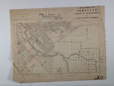 Bendigo Historical Society Inc.
Map - NEWSTEAD ALLOTMENTS, 10/06/1886
Map: Town ans Suburban Lots, Newstead, Parish of Strangwaysmap, allotments, newstead , allotments, parish of strangways