Showing 23748 items
matching sardine-creek
-
 Bendigo Historical Society Inc.
Map - TANDARRA : COUNTY OF BENDIGO, 14-3-24
Map. Tandarra, County of Bendigo, Talambe, Yallook, Neilborough, Whirrakee, Kamarooka. Myers Creek, Tandarra Estate. Photo-Lithographed at the Department of Lands and Survey, Melbourne by W.J. Butson, 14-3-24. Price 1/-. By authority Albert J. Mullett, Government Printer, Melbourne. (number 25 in map cupboard 1)Albert J. Mullett, Government Printer, Melbourne.map, bendigo, tandarra -
 Bendigo Historical Society Inc.
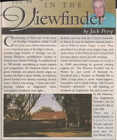
Newspaper - JACK PERRY COLLECTION: NEWSPAPER FOUNDRIES
Newspaper article discussing Harkness, Roberts & Son United Ironworks, Myers St later in Wills St where Target is now, Carter and Brown, Creek St., Phoenix foundry in Wattle St., Horsfield in Havilah Road, Central Foundry Eaglehawk Road ( Osborne's ) Eaglehawk Foundry, Caldwell's Road, Jobs Hill.bendigo, mining, harkness foundry -
Bendigo Historical Society Inc.
Map - DARGILE : COUNTY OF BENDIGO, November 1953
Map. Dargile, County of Bendigo, County of Rodney, Cornella Creek, Northern Highway, Crosbie, Redcastle, Knowsley East, Heathcote, Costerfield, Moormbool West. By authority W.M. Houston, Government Printer. Drawn and reproduced at the Department of Lands and Survey, Melbourne. November 1953. Price 2/-. (number 115 in map cupboard 1)W.M Houston, Government Printermap, bendigo, dargile -
Bendigo Historical Society Inc.
Map - CROSBIE : COUNTY OF BENDIGO, 1970
Map. Crosbie, County of Bendigo, County of Rodney, Toolleen, Weston, Dargile, Knowsley East, Redcastle, Township of Toolleen, Northern Highway, Mt.Pleasant Creek. By Authority R.H. Rixon, Government Printer, Melbourne. Drawn and reproduced at the Department of Lands and Survey, Melbourne. 1970. Price $1.00. (number 114 in map cupboard 1)R.H. Rixon, Government Printer, Melbourne.map, bendigo, crosbie -
Bendigo Historical Society Inc.
Map - WESTON : COUNTY OF BENDIGO : COUNTY OF RODNEY, 4-5-21
Map. Weston, County of Bendigo, County of Rodney, Muskerry, Crosbie, Knowsley East, Knowsley, Axedale. Back Creek. By authority A.J. Mullett, Government Printer, Melbourne. Photo-Lithographed at the Department of Lands and Survey, Melbourne by W.J. Butson 4-5-21. Price 1/-. (number 108 in map cupboard 1)A.J. Mullett, Government Printer, Melbourne.map, bendigo, weston -
Bendigo Historical Society Inc.
Map - HAWKESTONE : COUNTY OF BENDIGO, December 1953
Map. Hawkestone, Parish, County of Bendigo, County of Talbot, Sutton Grange, Redesdale, Faraday, Elphinstone, Metcalfe, Lyell, Coliban River, Myrtla Creek. By Authority W.M. Houston, Government Printer. Drawn and reproduced at the Department of Lands and Survey, Melbourne. December 1953. Price 2/-. (number 99 in map cupboard 1)W.M. Houston, Government Printer.map, bendigo, hawkestone. -
Bendigo Historical Society Inc.
Map - SALISBURY WEST : COUNTY OF BENDIGO, 3-3-1944
Map. Salisbury, County of Bendigo, County of Gladstone, Powlett, Yarrayne, Bridgewater, Inglewood, River Loddon, Bullabul Creek, Glenalbyn, Kurting. By Authority H.E. Daw, Government Printer, Melbourne. Drawn and reproduced at the Department of Lands and Survey, Melbourne., 3-3-1944. Price 5/-. (number 94 in map cupboard 1)H.E. Daw, Government Printer, Melbourne.map, bendigo, salisbury west -
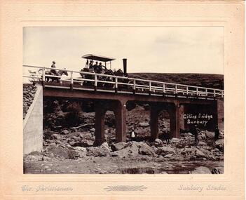 Hume City Civic Collection
Photograph
Chris. Christiansen was a barber in Sunbury. He also ran a photographic studio from 1892 - 1916. His business was situated on the corner of Evans and Brook Streets. The Gillies Bridge is Situated on the Wildwood Road just off the Lancefield Road.A mounted sepia photograph of the Gillies Bridge at Sunbury. Across the bridge there are three men on a steam roller and one man behind on horseback. There are four men standing across the creek bed. The mounting is cream, 2 cm wide with silver writing under the photo. Cream mounting - 2 cm wide with silver inscriptionsGILLIES BRIDGE / SUNBURY / CHR. CHRISTIANSEN /gillies bridge, wildwood bridge, bridges, horses, christiansen, chris, photographers, animals, steam rollers, sunbury, men, clothing and dress, george evans collection -
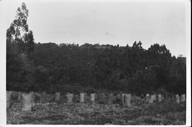 Southern Sherbrooke Historical Society Inc.
Photograph - Photo - Bagged-up spuds awaiting collection on Hermon's farm
B&W photo showing rows of filled potato sacks in a field at Hermon's farm on Black Hill Road, Menzies Creek. Land was leased from Forest Dept. Trees are in the middle ground and behind them, the ridge of Ridge Road can be seen. See also M0055 taken from the same position. -
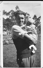 Southern Sherbrooke Historical Society Inc.
Photograph - Photo - Bill Hermon with his first daughter, Joy, in the 1940s
B&W photo of Bill Hermon holding a baby of about three months of age. Bill is wearing a sleeveless pullover over a shirt with rolled-up sleeves. They appear to be on the Hermon farm at Menzies Creek. In the field behind them is a metal hand roller. Beyond a small row of shrubs is a child's tricycle. 1940s. -
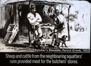 Bendigo Historical Society Inc.
Slide - DIGGERS & MINING. STORES AT THE DIGGINGS, c1852
Diggers & Mining. Stores at the diggings. Butcher's Shamble, Forest Creek, 1852. Sheep and cattle from the neighbouring squatters' runs provided meat for the butchers' stores. Slide shows miner checking out the meat for sale other items are also for sale. Markings: 23 994.LIF. 5. Used as a teaching aid.hanimounteducation, tertiary, goldfields -
 Bendigo Historical Society Inc.
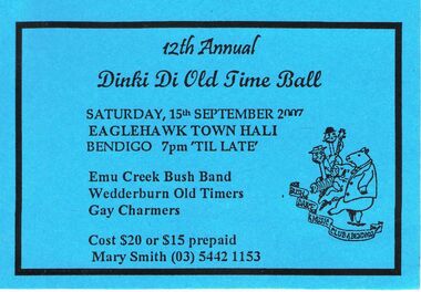
Document - PETER ELLIS COLLECTION: TICKET TO DINKI DI OLD TIME BALL 2007, 15th September, 2007
Two blue cards for the 12th Annual Dinki Di Old Time Ball Saturday 15th September 2007 at the Eaglehawk Town Hall Bendigo7pm 'til late. Emu Creek bush Band, Wedderburn Old Timers, Gay Charmers. Cost $20 or $15 prepaid, Mary Smith (03) 5442 1153entertainment, dance, dinki di old time ball -
 Bendigo Historical Society Inc.
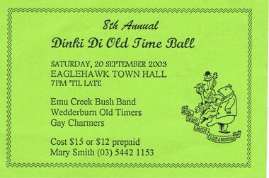
Document - PETER ELLIS COLLECTION: DINKI DI OLD TIME BALL 2003
Green card to 8th Annual Dinki Di Old time Ball to be held Saturday 20 September 2003 at the Eaglehawk Town Hall 7pm till late. Emu Creek bush Band, Wedderburn Old Timers, Gay Charmers. Cost $15 or $12 prepaid Mary Smith (o3) 5442 1153.entertainment, dance, dinki di old time ball -
 Bendigo Historical Society Inc.
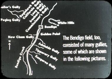
Slide - DIGGERS & MINING: THE DIGGINGS - THE DIGGERS
Diggers & Mining: The Digging - The Diggers. Slide depicts areas of Bendigo. Golden Point, New Chum Gully, Adelaide Gully, Tiperary Gully, Kangaroo Gully, Bendigo Creek, Pegleg Gully, Sailor's Gully, California Gullly, LongGully, Commissioner's Gully. Markings: 17 994.LIF:6. Used as a teaching aid.hanimounteducation, tertiary, goldfields -
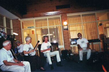 Bendigo Historical Society Inc.
Photograph - PETER ELLIS COLLECTION: EMU CREEK BUSH BAND, 25th November, 2007
Colour photograph. Members of Emu Creek Bush Band sitting in hall in front of windows. Toilets sign visible. Banjo, accordian and drum. Back of photo reads: Bendigo Retirement Village Sunday Nov. 25 2007 L-R Des Skinner, Olive Dobbyn, Julie and Don Maneypeney Peter Ellis.entertainment, music, emu creek bush band -
Tarnagulla History Archive
Allen marriage certificate (copy), 3rd October 1894
Donald Clark Collection.Photocopy of a Certificate of Marriage from Dunolly Gladstone district. Parties are Ebenezer Allen (31 years) of Hillsborough Farm, Kangedaar Creek near Tarnagulla and Jane Esther Laurie (27 years) of Laurie near Tarnagulla. Minister is Robert Thomson, Presbyterian Minister. Marriage took place at Red Hill Farm, Tarnagulla. -
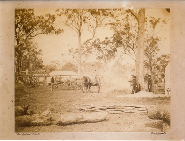 Bendigo Historical Society Inc.
Photograph - MYERS CREEK DIGGINGS, c1867
Sepia photograph: Myers Creek Diggings, Victoria, Australia. Photographed by Claver Carroll from original photo by Batchelder. Hut under construction with man on top of it on left, two horse and carts in center, four men with shovels on right. Tents and partly constructed hut in background. Inscriptions/Markings Batchelder Photo, Sandhurst.Claver Carrollplace, mining site, myer's creek diggings -
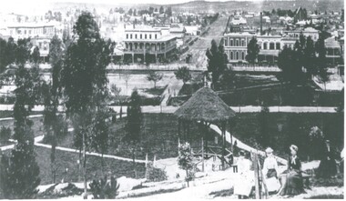 Bendigo Historical Society Inc.
Photograph - LANDSCAPE - BENDIGO - PRE-POST OFFICE
Photograph - black and white. Photo of a view over Bendigo, Shamrock Hotel in middle left. Group of women in immediate foreground. Rosalind Park, creek then bare land. Written on back of photo 'Pre-Post Office Blng - began 1883, Open 1887.' Came with negatives under name of Davidson, negatives are not of the photo.place, landscape view, hargreaves street from rosalind par, bendigo. pre- post office. rosalind park. landscape -
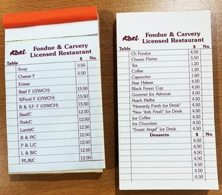 Falls Creek Historical Society
Ephemera - Koki Restaurant docket and order book
Order docket books used at Koki Fondue and Carvery Restaurant in Falls Creek during 1975. Shows menu items and price as well as how orders were taken. George Shirling arrived in Falls Creek in 1962. He engaged Phil Nowell to build the original Koki Alpine Lodge which opened in 1965 with 14 beds. George operated the lodge with Michael “Baldy” Blackwell as manager. He also graduated in sport psychology in 1981 and was invited to become team psychologist for the Australian Winter Olympic team which went to Albertville, France, in 1992. He later owned the Red Onion Chalet. George credited the success of Koki to “Baldy” Blackwell. “Baldy” and Phil Nowell started the Trackers Mountain Lodge in partnership during the 1980s. In 1971 George sold Koki Lodge to Sigh Doerr. Sigh was a long time resident of Falls Creek, owning and operating Koki Lodge for many years with his wife, Lee. He was Falls Creek CFA Captain from 1995 until 1998 although he served in the Fire Brigade for much longer. Sigh had many involvements in the community. In 2023 the renamed Koki Alpine resort remains a highly popular destination in Falls Creek operated by Doerr Nominees Pty. Ltd. under the management of Vesna Sugden.This item is significant because it has clear links to an iconic business established in Falls Creek, VictoriaTwo order docket books for Fondue and Carvery Licensed Restaurant, with paper connected at top edge with glue, each page containing name of restaurant at top of page with list of menu items and price in grid with section for table at left and order number at right. All printed in red. 'Koki / Fondue & Carvery / Licensed Restaurant'dining, 1970s dining, falls creek, koki, sigh doerr, george shirling -
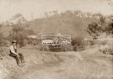 Eltham District Historical Society Inc
Photograph, Mr Belot smokes his pipe whilst resting at Cottle's Bridge, c.1890
The area, previously known as Back Creek, was named after Thomas Cottle, who settled in the district in the 1870s, and the original bridge over the Diamond Creek on the road to Strathewen. The original bridge (seen in the photo) was replaced with a new timber bridge at a cost of £1,500, the tender being awarded to a contractor named Birch who commenced work in June 1927. The gentleman in the photo who is resting whilst having a smoke of his pipe is a member of the Belot family.Original sepia photograph mounted on card broken lower left corner and cracked upper rightbelot, bridge, cottles bridge, cottles bridge-strathewan road, diamond creek (creek), heidelberg-kinglake road -
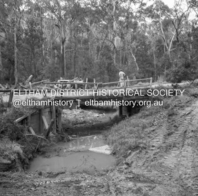
 Eltham District Historical Society Inc
Album - Photograph, J.A. McDonald, Eltham-Greensborough Road, 1957
Diamond Creek Bridge (Bridge Street Bridge) Inner Vertical pile downstream side Eltham abutment This pile appalled at head after this blow. 1957Record of various Shire of Eltham infrastructure works undertaken during the period of 1952-1962 involving bridge and road reconstruction projects, sometimes with Eltham Shire Council Project Reference numbers quoted. It was during this period that a number of significant improvements were made to roads and new bridges constructed within the shire that remain in place as of present day (2022). In many situations, the photos provide a tangible visible record of infrastructure that existed throughout the early days of the Shire. The album was put together by or under the direction of the Shire Engineer, J.A. McDonald.infrastructure, road construction, shire of eltham, bridge construction, bridge street bridge, eltham, eltham-greensborough road, 1957 -
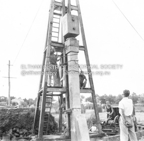
 Eltham District Historical Society Inc
Negative - Photograph, J.A. McDonald, Heidelberg-Kinglake Road, Sep 1959
Job 56M430 Contractor Hone Just south of east abutment and access road to house showing block in table drain and wash towards Diamond CreekRecord of various Shire of Eltham infrastructure works undertaken during the period of 1952-1962 involving bridge and road reconstruction projects, sometimes with Eltham Shire Council Project Reference numbers quoted. It was during this period that a number of significant improvements were made to roads and new bridges constructed within the shire that remain in place as of present day (2022). In many situations, the photos provide a tangible visible record of infrastructure that existed throughout the early days of the Shire. The album was put together by or under the direction of the Shire Engineer, J.A. McDonald.infrastructure, shire of eltham, bridge construction, 1959-09, heidelberg-kinglake road, road construction -
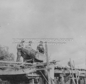
 Eltham District Historical Society Inc
Negative - Photograph, J.A. McDonald, Heidelberg-Kinglake Road, Oct. 1959
Job 56M431 Contractors Wolf and Wood Yow Yow Creek Bridge Showing condition October 1959 Bypass back upstream side under constructionRecord of various Shire of Eltham infrastructure works undertaken during the period of 1952-1962 involving bridge and road reconstruction projects, sometimes with Eltham Shire Council Project Reference numbers quoted. It was during this period that a number of significant improvements were made to roads and new bridges constructed within the shire that remain in place as of present day (2022). In many situations, the photos provide a tangible visible record of infrastructure that existed throughout the early days of the Shire. The album was put together by or under the direction of the Shire Engineer, J.A. McDonald.infrastructure, shire of eltham, bridge construction, heidelberg-kinglake road, 1959-10, road construction, scan - 120 format 6x6 negative, yow yow creek -
Greensborough Historical Society
Newsletter, Greenhills and North Greensborough Progress Association, Community News: official journal of the Greenhills and Nth. Greensborough Progress Association and the Apollo Parkways Progress Association. 1980, 1980
Duplication of Diamond Creek Road : the first stage of the F5 Freeway, Community News welcome back! But the news is not good!, Thunder over the hill, And it came to pass... Newsletter, 6 p.greenhills and north greensborough progress association, greenhills, apollo parkways progress association, apollo parkways -
 Greensborough Historical Society
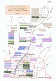
Maps, Yan Yean Water Supply System Conservation Management Plan: Construction dates Map 1, 2007_
Plan of Yan Yean Water Supply System, showing natural and constructed features from 1850s to 1930s from Silver Creek Weirs to Eastern Freeway.Printed in colour one side. 3 copieswater supply, yan yean reservoir, plenty river -
 Coal Creek Community Park & Museum
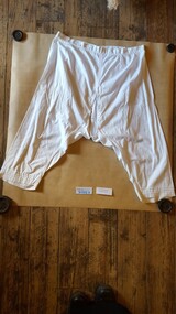
Ladies Nightdress and Undergarments, C1890
These garments were made by Evelyn Carfrae's grandmother for her trousseau around 1890. Evelyn Carfrae was a long time volunteer in O.Gilpins Store at Coal Creek.9056.1 Ladies long white nightdress with lace trimmed collar 9056.2 Ladies white mid calf length crotch less undergarment 9056.3 Ladies white calf length undergarment with drop down panel in front -
Coal Creek Community Park & Museum
trophy/cup
The 10 locals names and their scores are engraved on the front. Fish Creek were the runners up. A total of 6 teams competed in the competion from around the area. This trophy/cup is of social significance because it relates to the local Korumburra community in 1926. rifle club, trophy, guns, -
 Hume City Civic Collection
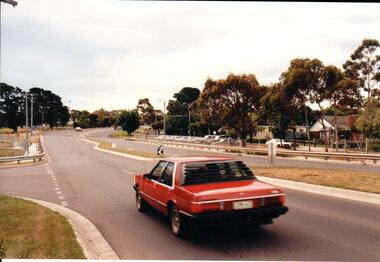
Photograph, Late 1990's
Riddell Road is the continuation of Macedon Street and is on the west side of the town centre. It is the main road to Riddells Creek, the Sunbury airstrip, Sunbury tip and water towers.A coloured photograph of Riddell Road looking west. A red car is in the foreground travelling north and is at the T intersection of Riddell Road and Ligar Street. There are houses along the north side of Riddell Road and the football ground is on the south side of the road.sunbury football club, riddell road, ligar street, george evans collection -
 Hume City Civic Collection
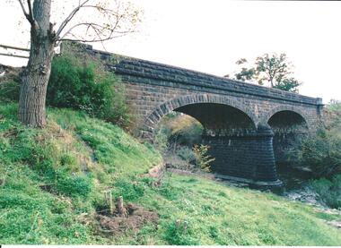
Photograph, late 1980s
The road bridge over Jackson's Creek in Sunbury was built in 1870 and was in use until a wider bridge was built when Sunbury Road was rebuilt in the early 1970s.A coloured photograph taken from the NE side of the river bank of a complete view of the bluestone bridge at Macedon Street. The two eliptical arches and the protruding pylon as well as the underside of the bluestone span are clearly visible.transport, roads and bridges, jacksons creek, harris, thomas lascelles, george evans collection