Showing 27536 items
matching yarra-river
-
 Federation University Historical Collection
Book, Northern Territory of South Australia Report Resulting from the Explorations by the Government Geologist, 1906, 1906
Pale blue soft covered geological and general report. It includes a chapter of Bathurst Island and Melville Island, Primitive Methhods of Chinese Mining, Early Days of Mining in the Northern Territory Images include sandbank at low tide, Douglas River, Granite at Union Hill, Night Cliff, East Point, union hill, zapopan gold mine Brook's Creek, Blow Gold Mine Yam Creek, Daly River Copper Mine, Mount Ellison Copper Mine, Point Charles Lighthouse, Blacks Camp near Point Charles Lighthouse, The Venture Stranded on a Daly River Sandbank, Hyland Bay Natives, Boabab Trees at Blunder Bay, The Wai Hoi, Mouth of Fitzmaurice River, Point Blaze Natives, Fort Hill and Old Gulnare Jetty Port Darwin, Large Anthill, Daly RIver Natives, Wargie Natives, L.C.E. Gee, H.Y.L. Brown, H. Basedow. F.J. Williamson, Aboriginal crew (Pedro, Peter, Tobatchie, Bubs, Loman), Henry Roberts, Schollert's Grave It also includes a large folder Geological Map of the North-Western District Northern Territory of South Australia. northern territory of south australia, geology, l. o'loughlin, douglas river, bathurst island, melville island, apsley straight, chinese, aboriginal -
 Kew Historical Society Inc
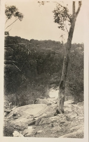
Photograph - Grampians, 1924
Henry Beater Christian (1886-1962) , was a descendant of one of the earliest settler families in Kew. Employed at the Kew Asylum as a 'public servant', he was a skilled amateur photographer, photographing numerous scenes in Kew and on his travels around Victoria. The majority of his photographs date from 1916 to 1929. His finest photographs are housed in two photograph albums. Digital copy of a photograph from page 13 of the 47-page photograph album containing 261 gelatinous silver images, loaned by Diane Washfold with permission given to digitise and hold a copy in our collection. The first and last pages in the album document the Yarra River at Studley Park and at Kew. The remainder of the album includes photographs of walking and car tours in rural Victoria including 'wilderness' areas in the Grampians, Gippsland and the High Country. Six album pages document a camping trip by Henry Christian to the Grampians in September 1924. The photos include pictures of lookouts, and natural features including rock faces and waterfalls, as well as his camp site. This photo is of a distant valley.. Unitled [Grampians]henry beater christian (1886-1962), landscape photography, christian-washfold collection, photograph albums, grampians, gariwerd -
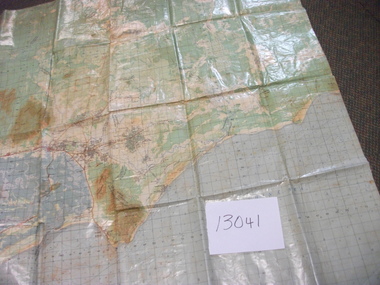
Federation University Historical Collection
Plan, R. Underwood, Shire of Winchelsea, 1952, 10/10/1952
Copy of a plan of the Shire of Winchelsea including Lake Wollard, Wormbete, angahook, boonah, Barwon Downs, Kaanglang, St Gerge River, Cumberland Creek, Stony Creek, Bambra, Wensleydale, yan Yan Gurt, Tutegong, Mirnee, Karngun, whoorel, Birregurra, Barwon River, Thompson's Creek, Bass Straight. Mt Defiance, Mt St George, Loutit Bay, Airey's Inlet, Salt Creek, Mathew's Creek.winchelsea, lake wollard, wormbete, angahook, boonah, barwon downs, kaanglang, st george river, cumberland creek, stony creek, bambra, wensleydale, yan yan gurt, tutegong, mirnee, karngun, whoorel, birregurra, barwon river, thompson's creek, bass straight. mt defiance, mt st george, loutit bay, airey's inlet, salt creek, mathew's creek, r. underwood, why river, point sturt, barwon downs, forest -
 Ballarat Tramway Museum
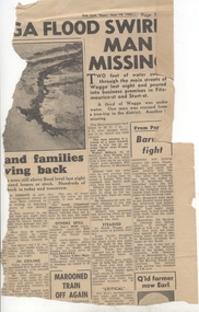
Newspaper, Herald Sun, "Barwon fight", 19/06/1952 12:00:00 AM
Newspaper Clipping from the Melbourne "The Sun", dated 19/6/1952 about widespread flooding in Victoria and Wagga and on the right hand side of the clipping the Barwon River Geelong titled "Barwon fight". Notes the flooding over the Barwon River which caused suspension of the tram services. Contained originally within Reg Item 5623 at the front of this note book. For items see btm5623 loose items list.pdf.geelong, flooding -
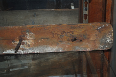
 Orbost & District Historical Society
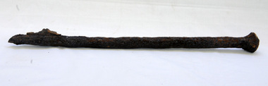
bridge spike
This spike came from the old Brodribb River bridge which is about 9.6 kilometres from Orbost. The Brodribb River joins the Snowy River north of Marlo. In 1906, a bridge replaced the punt over the Brodribb River, improving communication with Orbost. It was eventually replaced by a reinforced concrete bridge built by the Road Construction Authority in 1989 where the Princes Highway passes over the Brodribb RiverThis item belongs to a significant local structure which has been replaced.A very rusty iron bridge spike from the old Brodribb Bridge.brodribb-river bridge-spike -
 Kew Historical Society Inc
Plan, Melbourne & Metropolitan Board of Works : Borough of Kew : Detail Plan No.1302, 1910
The Melbourne and Metropolitan Board of Works (MMBW) plans were produced from the 1890s to the 1950s. They were crucial to the design and development of Melbourne's sewerage and drainage system. The plans, at a scale of 40 feet to 1 inch (1:480), provide a detailed historical record of Melbourne streetscapes and environmental features. Each plan covers one or two street blocks (roughly six streets), showing details of buildings, including garden layouts and ownership boundaries, and features such as laneways, drains, bridges, parks, municipal boundaries and other prominent landmarks as they existed at the time each plan was produced. (Source: State Library of Victoria)This plan forms part of a large group of MMBW plans and maps that was donated to the Society by the Mr Poulter, City Engineer of the City of Kew in 1989. Within this collection, thirty-five hand-coloured plans, backed with linen, are of statewide significance as they include annotations that provide details of construction materials used in buildings in the first decade of the 20th century as well as additional information about land ownership and usage. The copies in the Public Record Office Victoria and the State Library of Victoria are monochrome versions which do not denote building materials so that the maps in this collection are invaluable and unique tools for researchers and heritage consultants. A number of the plans are not held in the collection of the State Library of Victoria so they have the additional attribute of rarity.Original survey plan, issued by the MMBW to a contractor with responsibility for constructing sewers in the area identified on the plan within the Borough of Kew. The plan was at some stage hand-coloured, possibly by the contractor, but more likely by officers working in the Engineering Department of the Borough and later Town, then City of Kew. The hand-coloured sections of buildings on the plan were used to denote masonry or brick constructions (pink), weatherboard constructions (yellow), and public buildings (grey). The absence of buildings and or property in Kew facing the Yarra is the most notable feature of this plan. Walmer Street and its bridge stretched, then and now, from Studley Park Road to Victoria Street, Richmond. On the Richmond side of the Yarra, there was evidence in 1904 of industry (‘Wool shed’; Soap Works’) and entertainment (‘Skittle Alley’). In reality, another Plan (No.1303) shows Chinese Gardens bordering the Yarra on the Kew side and buildings in Young Street.melbourne and metropolitan board of works, detail plans, mmbw 1302, cartography -
 Melbourne Tram Museum
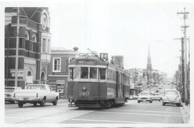
Photograph - Set of 4 Black & White Photograph/s, Clive Gibson?, c1975
Set of four Black and White photographs of W2 380. Photos not dated, c1975. .1 - Toorak Road, just past Osborne St, South Yarra, with the South Yarra Post Office in the view. Also Helmuts Milk Bar? Tram has the destination of Chapel St, route 8B. .2 - Turning from Park St South Yarra into Toorak Road. Tram has the destination of Toorak, route 8. Note the Bundy clock on the left hand pole. .3 - In St Kilda Road, at the Arts Centre, with destination of Elsternwick, Route 4E. .4 - turning from Toorak Road into Park St, route 8. See image i5 for envelope which has the names of Clive Gibson, Dave Menzies and date 1975 which could be the date the photos were sent to Dave Menzies for some reason.trams, tramways, w2 class, bundy clock, route 8b, toorak road, south yarra, park st, route 8, st kilda rd, route 4e, elsternwick, tram 380 -
 Melbourne Tram Museum
Document - Personal Papers, Wikipedia, Max Hayes, Copies of Wikipedia pages re buses and tram in Melbourne, 6/07/2006 12:00:00 AM
Personal papers - set of 9 copies of pages downloaded from the Wikipedia pages all accessed 6/7/2006 of use in the provision of information to "Tickets Please". Shows what information was available at the time. Most sheets have been stapled. Comprises: 1 - National Bus Company (2006) - 2 sheets 2 - Ventura Bus Lines - 4 sheets 3 - Skybus Metcards - 2 sheets 4 - Melbourne’s Tram History - 4 sheets 5 - Melbourne’s cable trams - 2 sheets 6 - 100 years of electric trams - photo gallery - 2 sheets 7 - Yarra Trams - trams in the war years - 2 sheets 8 - The history of Yarra Trams - 1 sheet 9 - A Century of electric trams in Melbourne - multiple sheets ex Yarra Trams website. - listed by decade - 28 sheets.trams, tramways, centenaries, 100 years of electric trams, buses, metcard -
 Bendigo Military Museum
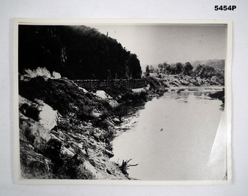
Photograph - PHOTOGRAPH, WAMPO BRIDGE, C1943-1948
REFER TO CAT 5445.2Photograph black and white. River, jungle covered hills. In the centre of the photo is a rail trestle bridge set against the steep hillside. The trestle bridge is made from timber On the rear of the photograph in ink. - 122326 WAMPO BRIDGE THAILAND- BURMARAILWAYww2, pow, burma railway -
 Bendigo Military Museum
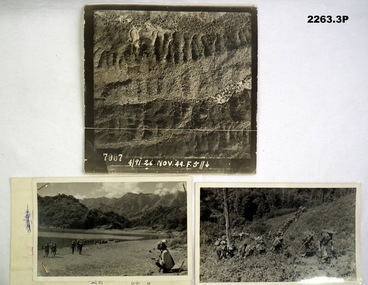
Photograph - PHOTOGRAPHS, BURMA, 26th Nov 1944
Items in the collection re Ian McLeod RWAFF, refer Cat No 2262.2.1) Aerial Sepia photograph countryside Burma. .2) Black and White photo Burma river, mountains and "kumi" natives. .3) Black and White photograph Burmese Jungle..1) “4191. 26 Nov. 44” .2) “Burmese Campaign 1944” .3) “Burmese Jungle 1944”burma, aerial, photographs -
 Orbost & District Historical Society
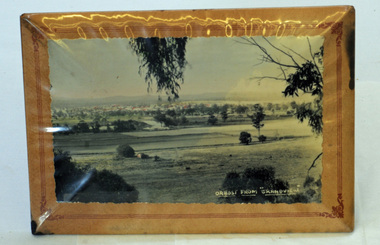
framed photograph, Orbost From "Grandview", mid 20th century
This photograph was taken from Grandview overlooking the Orbost flats.A black/white photograph in a frame. The frame has a stand. The frame is card padded over a metal frame. It is covered in plastic. The photograph is of the Orbost flats with the river and the town in the background.in white - "Orbost From "Grandview"grandview orbost-flats photograph -
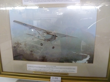 National Vietnam Veterans Museum (NVVM)
Print, Bird Dog Over Vietnam
Gold framed bone matt board colour print of a Cessna Bird Dog single engine light aircraft flying over jungle with mountains in the background and river belowForward Air Controllers in Vietnam 1965 - 1971. Bird Dog Over Vietnam. Donated by the FAC Association - presented by the RAAFVVAcessna o.1 bird dog, framed print -
Port Melbourne Historical & Preservation Society
Photograph - Nairana ashore at Port Melbourne, Taroona, inner west, Station Pier, Glen Stuart, 1950s
One of nine photographs taken of various ships at Port Melbourne and river berths in the early 1950s: Nairana ashore at Port Melbourne, Taroona inner west Station Pierpiers and wharves - station pier, transport - shipping, taroona, nairana -
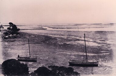 Churchill Island Heritage Farm
Photograph of two boats, c.1890s
Churchill Island Heritage Farm has a large photograph collection dating from the mid-nineteenth century to the last decade.This series of photographs were taken in the late 1890s and show scenes from around the island while it was owned by Samuel Amess and his family.Black and white reprint of a photograph from the late nineteenth century showing two boats resting on the river floor at low tide. A man sits in the rear of the second boat.Catalogue number written in pencil on reverse. amess house, samuel amess, churchill island, photograph -
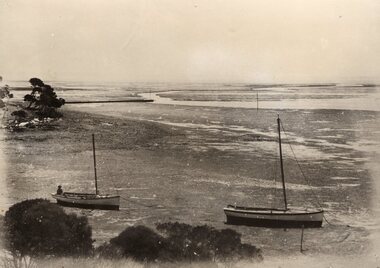 Churchill Island Heritage Farm
Photograph showing two boats resting on the mud, 19th century
Churchill Island Heritage Farm has a large photograph collection dating from the mid-nineteenth century to the last decade.This series of photographs were taken in the late 1890s and show scenes from around the island while it was owned by Samuel Amess and his family.Black and white reprint of a photograph from the late nineteenth century showing two boats resting on the river floor at low tide. A man sits in the rear of the second boat.Catalogue number written on reverse in pencil. Written on reverse in pencil 'Department of Agriculture' Stamp on reverse 'Photograph by Information Branch Victorian Dept. of Agriculture Ref. No 1978(541-26)churchill island, amess house -
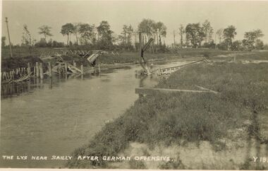 Bendigo Historical Society Inc.
Postcard - ACC LOCK COLLECTION: THE LYS NEAR SAILLY AFTER GERMAN OFFENSIVE, POSTCARD, 1914-1918
Postcard, WW1, B&W image of the timber remains of a bridge over the river Lys near Sailly after a German offensive. Possibly a footbridge. Copy y 18postcard, postcard, ww1, sailly, german offensive, bridge -
 National Vietnam Veterans Museum (NVVM)
Map, Intelligence Map
Vinyl coated topographical map of part of Vietnam featuring main roads, towns and city locations current or ruined. River locations etc. Names all in Vietnamese language.map, vietnam -
Tatura Irrigation & Wartime Camps Museum
Book, Finland, 1997
The book covers Finnish culture from religion, rock and roll, mythology to media, education, food, history, fashion. Inlcudes loose card with lake scene.Cream wrap around cover. River scene in frame on front by M Viljanen. Cover design - M Itkonen. Back cover - Golilla Taina Varri. 350 pages.finland culture, walczuk e, tatura, european history -
 Anglesea and District Historical Society
Ship Railing, 1895
"Inverlochy" wrecked 1902.Part of the railing from the "Inverlochy" which wrecked in 1902 on the "Ingoldsby" reef, Anglesea River, 1902. Includes three nails protruding at right angles from the wooden piece.inverlochy, ship railing -
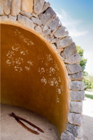 City of Ballarat
Artwork, other - Public Artwork, Deanne Gilson, Murrup Laarr by Deanne Gilson, 2019
Murrup Laarr translates as 'Ancestral Stones' in Wadawurrung. This artwork by Dr Deanne Gilson is located in the North Gardens Indigenous Sculpture Park. The park is a significant project for the City of Ballarat and features works by Aboriginal and Torres Strait Islander artists, celebrating the richness and diversity of culture and telling important cultural stories. Dr Deanne Gilson is a Wadawarrung Traditional Custodian and established artist. She installed the first artwork commissioned by the City of Ballarat for the Sculpture Park in early 2019. Murrup Laarr is a contemporary artwork consisting of a traditionally-built stone hut in the middle of a circle of basalt standing stones, marked with ceramic plates reflecting the stories and symbols of dreaming, memory, ceremony.The artwork is of aesthetic and cultural, social and spiritual significance to the people of Ballarat and to Wadawurrung peopleA traditional hut made from river stone and stacked rocks, with the hut surrounded by large basalt rocks with plaques featuring unique designs on stoneware plates imbedded into them. Murrup Laarr (Ancestral Stones), 2019 / By Deanne Gilson / Wadawurrung people have always used stones to mark places of ceremony and important business. The stones are the holders of memory and knowledge, Country and Spirit. They mark the cosmos and seasons. They follow the sun, marking the summer and winter solstice, important dates for planting and harvesting and telling stories of past, present and future. / The stones are alive and still present. Murrup Laar has been created using local basalt stones to tell Wadawurrung stories of dreaming, memory and ceremony. / “Creating Murrup Laarr (Ancestral Stones) at this time has placed Aboriginal people and practices back on Country and created a place to tell our stories. I am very honoured to have had this opportunity. An Aboriginal stone circle existed in Ballarat pre-colonisation; by putting back what was lost throughout colonisation I pay homage to my ancestors, past, present and emerging”/ – Deanne Gilson, March 2019 murrup laarr, wadawurrung -
Lakes Entrance Regional Historical Society (operating as Lakes Entrance History Centre & Museum)
Photograph, 1920 c
Also another black and white photograph of same view with a man in foreground 05298.1Black and white photograph showing view of Reeves River looking west towards Metung with islands Rigby and Flanagan on left and Nungurner on right Jemmys Point Lakes Entrancewaterways -
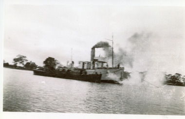 Lakes Entrance Regional Historical Society (operating as Lakes Entrance History Centre & Museum)
Photograph, 1917
Typed note in album describes the photoBlack and white photograph showing PWD dredge WH Edgar with hopper barge during dredging operation at mouth of Mitchell River. Silt jetty at back. Bairnsdale Victoriaboats and boating, jetties, islands, waterfront -
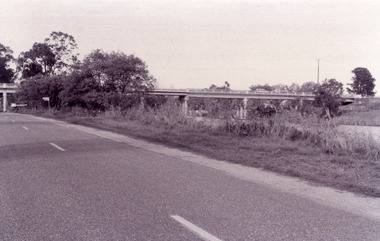
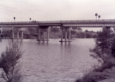 Lakes Entrance Regional Historical Society (operating as Lakes Entrance History Centre & Museum)
Photograph, Fish Marie, 1995
Black and white photograph showing view of the Swan Reach bridge over the Tambo River. Traffic lights on bridge to control traffic and reduce weight. Swan Reach Victoriabridges, waterways -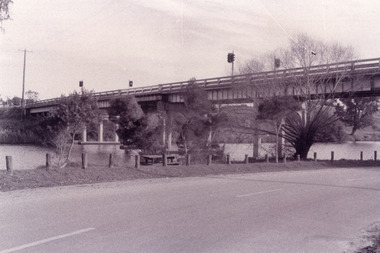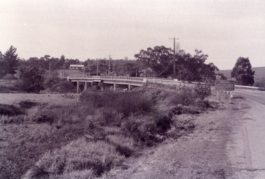
Lakes Entrance Regional Historical Society (operating as Lakes Entrance History Centre & Museum)
Photograph, 1902
Also a small black and white postcard showing same photograph 04590.1Black and white photograph showing rowing skull with eight crew on Mitchell River large crowd of onlookers on bank during official opening of Rowing Club at Bairnsdale VictoriaBiarnsdale Rowing Clubadvertising, businesses, celebrations -
 Wodonga & District Historical Society Inc
Album - Hume Reservoir Australia Album - Core wall with drainage tunnel and earth embankment in progress in Victoria, June 1924, 1927
This set of photos is from a leather bound album bearing the inscription "HUME RESERVOIR AUSTRALIA" plus 'The Rt. Hon. L. C. M. S. Amery, P. C., M .P.' all inscribed in gold. It was presented to The Rt. Hon. L. C. M. S. Amery, P. C., M. P, Secretary of State for Dominion Affairs on the occasion of his visit to the Hume Reservoir on 2nd November 1927. This album is of local and national significance as it documents the planning and development of the Hume Reservoir up to 1927. It was the largest water reservoir in the British Empire. The album records the pioneering engineering work that went into its construction.DEPARTMENT OF PUBLIC WORKS, N.S.W. RIVER MURRAY WATERS SCHEME. HUME RESERVOIR. 14. Core wall with drainage tunnel and earth embankment in progress in Victoria, June 1924.hume reservoir australia, river murray waters scheme, hume reservoir construction