Showing 10954 items matching " land"
-
 Bendigo Historical Society Inc.
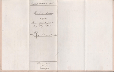
Legal record - FOGGITT JONES & CO. Land sale notes, Watson, James & Rogers, Rogers Collection, 1.7.1913
In the early 1980s the firm of Watson, James & Rogers merged with the partnership of Every & Every and became the iconic “Rogers & Every” as known today. The firm is still located on Bull Street. https://rogersevery.com.au/about/Sale notes to sell land in (Residence Areas), Wade St. Golden Square to Foggitt Jones & Co. Sold all Rights to Titles and Interests. Typed on light brown paper. 1. Joseph Mitchell and Mary Ann Roberts (10317 and 10318) 2. Elizabeth Roberts (10319) 3. Alice Emily Ann Roberts (13126) 4. John Frances Roberts (10363) 5. William Davies Osborne (9805) Release by Mrs Irene Catherine Orrock for Foggitt Jones & Co. handwritten on cream coloured paper.Signatures.land sales, foggitt jones and co. -
 Bendigo Historical Society Inc.
Document - NEW CHUM LINE OF REEF - GOLD PRODUCTION ON THE NEW CHUM LINE OF REEF
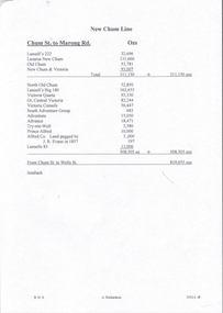
Handwritten page containing the names of mines and the number of ounces of gold they produced. Mines mentioned are: Lansell's 222, Lazarus New Chum, Old Chum, New Chum & Victoria, North Old Chum, Lansell's Big 180, Victoria Quartz, Gt Central Victoria, Victoria Consols, South Adventure Group, Adventure, Advance, Try - Me - Well, Prince Alfred, Alfred Co, Lansell's 83 and Ironbark (no production figures). Note beside Alfred & Co - Land pegged by J R Evans in 1857.document, gold, new chum line of reef, gold production on the new chum line of reef, lansell's 222, lazarus new chum, old chum, new chum & victoria, north old chum, lansell's big 180, victoria quartz, gt central victoria, victoria consols, south adventure group, adventure, advance, try - me - well, prince alfred, alfred co, lansell's 83, ironbark, j r evans -
 Flagstaff Hill Maritime Museum and Village
Photograph - S. S. Casino, Early 19th century
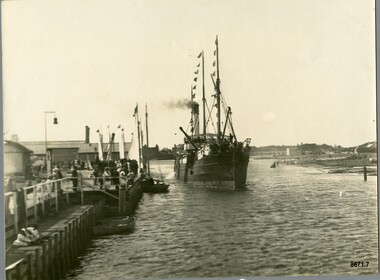
This photograph was one of ten photographs donated to Flagstaff Hill Maritime Museum and Village by Fred Trewartha. Frederick John Fox Trewartha (Fred) was a well-known Warrnambool businessman. He was born in Beeac near Geelong in 1920 and came to Warrnambool with his family as a very young child. He was apprenticed to his father John, as a saddler and later opened his own shop on Raglan Parade. He then moved into working with tarpaulins and canvases for the trucking industry. Fred was keenly interested in photography (and was a member of the Warrnambool Cine Club), yachting and boat building. He kept his yacht moored at Port Fairy for many years and participated in sailing events locally and interstate. He also built boats with his sons. He had the opportunity to meet many older sailors and it's thought this photo (and others in the set) may have been given to him by one of these men. Fred Trewartha died in 2016 in Warrnambool. The S.S. Casino was a passenger and freight steamer built in Dundee, Scotland, in 1882 for the Newcastle and Hunter River Steam Navigation Company of N.S.W. She weighed 425 tons gross with a length of 160.4 feet, beam of 24.1 feet and a depth of 10.2 feet. She had saloon accommodation for 35 people, a fore cabin for 25 more people, and she carried 300 tons of cargo. While on her delivery journey on May 30th 1882, the S.S. Casino called in at the Port of Warrnambool for coal, narrowly escaping going ashore in gale force winds due to the quick action of the pilot. At that time, still at anchor, she impressed the directors of the Belfast and Koroit Steam Navigation Company so much that they bought her immediately; she was ideal for trade along the West Coast of Victoria. (The Belfast and Koroit Steam Navigation Company was first managed by Messers. Saltau and Osburne and after the passing of Mr. Osburne, by produce merchants Messers H. Sautau and Sons, who had a hay and corn store and shipping agency on the corner of Liebig and Koroit Streets in Warrnambool. ) The S.S. Casino became “the most famous steamer to operate in Victorian waters along the West Coast” by author Jack Loney. Captain Boyd was her first Master, followed by Captain Chapman, who stayed with her from 1890 until 1924. Captain W. Robertson followed for a short term, and then Captain Middleton then took command from 1925 - 1932. An article published on Monday 11th June 1932 in The Sun News Pictorial (Melbourne) giving a detailed history of S. S. Casino said "owned by Port Fairy interests, she was an integral part of the town's development ... for a long time, her arrival in Port Fairy was an event, the townspeople going down to the wharf to see her come in". It also said "Except when the weather was bad, the Casino hugged the coast on her trips and passengers obtained wonderful views of the sandstone terraces and caves. A little time ago every member of her regular crew except one, was a Scotsman." This particular photograph of the S.S. Casino shows it decorated with numerous flags in "holiday rigging". During the years between 1884 and 1915, the Casino would take locals and holiday makers on excursions around the Port Fairy Bay. Local towns such as Terang, Penshurst and Mortlake held their Picnic Days in Port Fairy and excursions on the Casino would be available for them and in 1906 Terang and District Schools held an excursion to Port Fairy (where the Casino was organised to provide a series of trips around the Bay.) In 1916 new regulations introduced by the Marine Board requiring the Casino to carry enough lifebelts for every passenger on board, prevented the steamer from making trips around the Bay on excursion days. The S.S. Casino had several mishaps during her life. One was on 3rd January 1898 when she collided with the S.S. Flinders in Apollo Bay with minor damage. Another was on 24th October 1924 when she grounded on a reef at Point Hawdon near Grey River and most of her cargo (of Christmas goods) had to be dumped into the sea. Then in February 1929 she was ‘holed’ when she struck a submerged object as she entered Lady Bay, Warrnambool. In the years following the turn of the century, the S.S. Casino remained the only regular trader with normal passenger accommodation along the West Coast. From 1882 she had made at least 2,500 voyages on the one run. On the morning of 10th July 1932, after attempting to berth at Apollo Bay jetty in heavy seas, Captain Middleton decided to take her out into the bay and wait until the seas abated. It was not realised that the anchor used to steady her as she manoeuvred to her berth had pierced her hull. She put about and headed for the beach but sank. Captain Middleton and nine others lost their lives; nine people were rescued including the two female passengers. Captain Middleton had been in charge of the S.S. Casino for seven years. He was the first ship’s Master to lose his life in a shipwreck in the West Coast trade. In June 1932, the directors of the Belfast and Koroit Steam Navigation Company had proposed to celebrate the completion of fifty years of trading by the steamer Casino in August, but tragically the Casino was wrecked only one month later (and "was only one month off completing its fifty years of valuable service between Melbourne and Portland.") Flagstaff Hill’s collection has a photograph of a portrait of Captain Chapman, a ship model of the S.S. Casino that shows both forms of power under which she sailed, steam and sail. The ship is painted green and flies three flags. The inscription across the case of the ship model, incorrectly dated, tells the sad story of the wreck of the ship and the loss of lives on July 10th 1932 at Apollo Bay. A print in the Collection shows S.S. Casino underway in the heavy sea off Point Lonsdale, another two photographs show her at the Port of Warrnambool, leaving from the Breakwater in Lady Bay and another identifies the S.S. Casino as a ship from the Belfast and Koroit Steam Navigation Company. (Belfast is the original name for the township of Port Fairy).This photograph is significant because of its association with the coastal trader S.S. Casino and its significance to trade along Victoria's West Coast in the late 19th and early 20th centuries. The wreck of the S.S. Casino is considered an important part of Victorian and Australian cultural heritage and as such has been declared and protected as an Historic Shipwreck under State and Commonwealth Law in the Commonwealth Historic Shipwrecks Act (1976).A black and white photograph showing a small steamer with decorative flags on both masts, coming into up a river towards a pier where a small crowd is waiting. The pier on the left of the photograph has several buildings and a bell on it. Three small boats are tied up to the dock. Low lying land with several buildings scattered on it can be seen on the right hand side. On the back of the photograph are handwritten labels. One is printed in dark blue ink and one is written in cursive writing in biro. There is also the number 6944 stamped in the centre of the photograph.Back - Donors name, address and telephone number 6944 "CASINO IN HOLIDAY RIG" "at Port Fairy"flagstaff hill maritime museum and village, warrnambool, great ocean road, shipwreck coast, s. s. casino, steamer casino, casino, port fairy, captain chapman, belfast and koroit steam navigation company, saltau and osburne, captain middleton, apollo bay, apollo bay shipwreck, lady bay -
 Bendigo Historical Society Inc.
Book - MINING REPORTS: MINING BY-LAWS OF AND FOR THE STATE OF VICTORIA
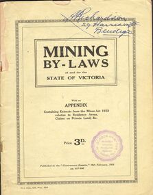
Printed 40 page booklet with a pale green cover titled 'Mining By-laws of and for the State of Victoria with an Appendix Containing Extracts from the Mines Act 1928 relative to Residence Areas, Claims on Private Land, &c. Published in the 'Government Gazette,' 19th February, 1931 pp. 617 - 640. Purple stamp on the front: 'W. Gordon Hampton, Bendigo, Vic. Bookseller, Librarian, Newsagent, Stationer.' A Richardson 29 Harrison St Bendigo written in blue pen on the front. Booklet contains advertisements relating to the mining industry.book, mining reports, mining reports, mining by-laws of and for the state of victoria, a richardson, w gordon hampton, government gazette -
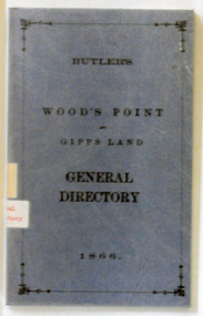 Orbost & District Historical Society
book, E-Gee Printers Pty Ltd, Butlers Wood's Point and Gippsland General Directory, 1985
This is a reprint of an original which was published in Melbourne by Butler & Brooke, Little Collins Street East. The original printer was W.H.Williams, 23 Little Bourke Street, Melbourne. On the spine was the title: Wood's Point and Gipps Land general directory, 1866.This is a copy of contemporary records of residents and businesses of Woods Point and Gippsland of 1866. It is a useful research tool.A soft covered 97pp book covered in clear plastic. The cover is blue with the title "Butlers Wood Point and Gippsland Directory" in black print with a black page border. It is a directory of residents, contemporary businesses (1866) and road guides. directory-gippsland-1866 butlers-directory -
 Glen Eira Historical Society
Document - Vadlure Avenue, 2, St. Kilda East
Printed and handwritten research from Brighton Historical Society giving brief details on 2 Vadlure Avenue, regarding subdivision of land formerly grounds of Kilwinning and residents of property from 1931 to 1974. Dated 19/01/1988.vadlure avenue, st. kilda east, service james, land subdivisions, 'kilwinning', denman street, kosky samuel, mcardle daniel j., elisha e., elisha d., bullock h., landells rosalind -
Glen Eira Historical Society
Document - McCombie St, 11, Elsternwick
Contains original typed document from Brighton Historical Society, dated 19 January 1989, regarding 11 McCombie St, Elsternwick and 2 handwritten documents which contain the same research on the residents and previous land owners.mccombie st, ripponlea, elsternwick, port charles h., north rd, bradlury arthur, davis peter, thomas kenneth d., sargood mr, bullock m -
 Bendigo Military Museum
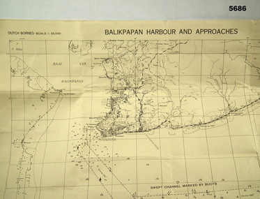
Map - MAP, DUTCH BORNEO
Map identified height of land in area and depth of ocean on approached to Balikpapan Harbour. Identified piers, streets and defences and potentially used for landing or combat in the area. MAP PRODUCED BY 2/1 AUST ARMY TOPO SQN CO. Large Yellow paper map with scale of 1:36,000 of Dutch Borneo Balikpapan Harbour and it's approaches. Map folded into 8.balikpapan harbour, maps -
 Bendigo Military Museum
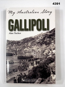
Book - GALLIPOLI BOOK, Scholastic Australia Pty Ltd, Gallipoli. My Australian Story, This edition 2017
Juvenile fiction, diary of a 14 year old soldier to land at ANZAC Cove 25th April 1915. The book is dedicated to the Fighting 10th/1st AIF, 3rd brigade and Clifford Claudias Schroder 1st Div Signal Company.Book, soft cover cardboard, dark green and black print on front, spine and back covers, front cover illustrated B & W photograph of “Troops landing at Gallipoli Cove Gallipoli 1915”, back cover has small black silhouette of a slouch hat.books military, history, juvenile fiction, ww! -
Phillip Island and District Historical Society Inc.
Photograph, 1990
This grave commemorates the memory of Matilda, daughter of Joseph and Sara Richardson; she died in Feb 1873 aged 8. The Richardsons bought land on Phillip Island in 1868 and named their home Everton. This is now Tallawalla in Church Street, Cowes.Photograph of grave of Matilda, daughter of Joseph and Sara Richardson in Phillip Island CemeterySacred to the memory of Matilda, the beloved daughter of Joseph and Sara Richardson, died Feb 1878 aged 8 yrs.local history, photography, photographs, slides, film, matilda richardson grave, phillip island cemetery, coloured photograph, richardson family -
 Greensborough Historical Society
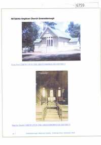
Article and Photograph, All Saints' Anglican Church Greensborough, 2018_
Information and photos of the original All Saints' Church of England in Greensborough, including an internal photo. The land was later sold to Coles to build a new store and the Church was rebuilt on its current site on corner of Grimshaw and Church Streets Greensborough. This photograph and text was copied from a Facebook site. Members are people who lived in the Greensborough area and share their reminiscences of the area with others. The site is administered by a GHS member but is not officially affiliated with the Society. Any information is the opinion of the contributor. Article and photograph sourced from social media.all saints church of england, all saints anglican church greensborough -
 Greensborough Historical Society
Photograph - Digital image, Hetta Bosch, 1889c
Photograph of Hetta Bosch. Johannes Bosch and family migrated from Southern Germany to Greensborough district c1889. They farmed along the Plenty River having purchased land from Flintoff. They later changed their surname from Bosch to Bush.Digital copy of black and white studio photograph.hetta bosch, johannes bosch, bosch family, bush family -
 Greensborough Historical Society
Memoir, Life at Alwyn - 1950s and 60s by Faye Fort, 2011
Faye Fort recounts stories about growing up in the Partington home "Alwyn" in the mid 20th century. At this time agriculture played an important role in the Greensborough district and the land around Alwyn was used for poultry, vegetables and cut flowers.A primary source recollection of Greensborough in the mid-20th century.2 typed pages and handwritten manuscriptfaye fort, partington family, alwyn, whatmough park -
 Greensborough Historical Society
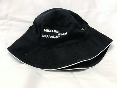
Hat, Medhurst Wines, Yarra Valley, 2016_
This hat was purchased at Medhurst Wines, Yarra Valley, as a gift for Faye Fort, who is a descendant of the Medhurst family. After leaving Greensborough, the Medhurst family moved to Gruyere in the Yarra Valley. They farmed the land that is now the vineyard that bears their name.Black polyester cotton sun hat with company logo in white stitchingLogo: "Medhurst Wines Yarra Valley"medhurst family, medhurst wines yarra valley -
 Orbost & District Historical Society
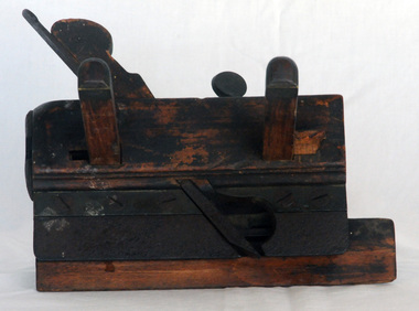
roughing plane, c. 1890 - 1950
Owned by the Mundy family of Orbost district. The Mundy family were farmers / settlers in the Snowy River area since c. 1880s. The original Mundy family moved to a land "selection" at Betebolong in the early 1880's from Buchan. Mundy familyA roughing plane made of wood with a small blade, held together with metal bolts. Also called a grooving plough plane.WHM is stamped into the wood (WJM?)grooving-plane roughing-plane woodworking-tool -
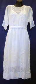 Orbost & District Historical Society
dress
This dress and petticoat come from the estate of James Cameron who was one of the first Snowy River councillors for the Tambo Shire. He selected land at Lochiel in 1892. From 1902-1920 he was the Assembly member for East Gippsland.A white voile dress with a white cotton petticoat underneath. It is not attached. The dress has a lace frill at the hem. It has lace inserts - two at the bodice and along the three-quarter length sleeves. There are several lace inserts on the skirt. It has been machine embroidered.dress costume cameron-james -
Glen Eira Historical Society
Article - MCKINNON
Brief typed history of McKinnon settlement taken from Moorabbin A Pictorial History 1862-1994 by John Cribben. Includes photocopied pages of railway gates, five land estate flyers and an article from the McKinnon Progress, undated.mckinnon, cribben john, crop production, markets, farmers, elster creek, mcmillan archibald, thomas street, centre road, wheatley road, vineyards, south road, ormond, brighton, moorabbin, irish, immigrants, bentleigh, priests, hanrahan pierce, hanrahan johanna, caroll michael, caroll catherine, howes eliza, howes john, howes edward, shanahan denis, shanahan ellen, gould james, gould catherine, howes george, bignell road, jasper road, tucker road, mcguiness family, quinn family, halinan family, malane family, inns, the gardeners arms, mckinnon hotel, bent james, bent thomas, tickets of leave, murray road, were nicholas, sargood family, ripponlea, mansions, elsternwick, st. stephens’ common school, church of england, school houses, evelyn street, st. john’s anglican church, telegraph offices, post offices, state schools, manchester road, north road, nicholls buildings, rivers frank, rivers ray, shops, pridgeon mr., elm grove, sobrin mr., clark misses, greaves bakery, armitage mrs., rout mr., tunnicliffe mrs., lance’s milk bar, johnson’s hardware shop, stiringer mrs., white horrie, robinson’s, mcinnerney’s flower shop, jean darling’s cakes, wyles jim, mckinnon progress association, glen orme avenue, ormond theatre, theatres, lester harry, the plaza, railway crossing, railway gates, wright street, nichols l., builders, pine grove, halls, st. elmo estate, patterson station estate, patterson road, brewer road, purton road, clee hill estate, railway park, hawthorn grove, wattle grove, elm grove, learys estate, manchester road, selkirk avenue, masters estate, lancaster street, moylan street, moorabbin railway crossing -
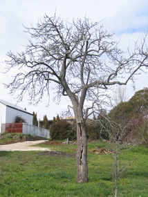 Victorian Interpretive Projects Inc.
Photograph - Colour, Clare Gervasoni, Fabrizio Crippa's Pear Tree, Hepburn Springs, 27/08/2006
Fabrizio Crippa of Monza, Italy built a double storey villa in 1864 on the Main Road in Hepburn Springs. The surrounding land was planted with vines and fruit trees. The pear tree is most probably one of Fabrizio Crippa's original plantings.Am old pear tree stands in a garden with a building in the back ground. hepburn, hepburn springs, pear, villa parma, parma house, crippa, fabrizio crippa -
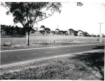 Hume City Civic Collection
Photograph, c1960s
The photograph overlooks former railway land along Vineyard Road which is now a commercial and light industrial estate. It was taken before curbing and footpaths were laid and Vineyard Road was narrow strip of asphalt with the sides of the road unmade.A black and white photograph of Vineyard Road with the Sunbury Railway line visible across the middle distance and the former Sunbury Asylum site in the background.vineyard road, sunbury asylum, sunbury railway line, george evans collection -
Stawell Historical Society Inc
Archive - Finance, Papers
Rural Finance Land Titles Sales Smith St Sth Standard association of Australia Licence Morias Pty Ltd Agreement Agreement between R.Maxwell & North Western Woollen Mills Melbourne Wool Brokers Authority to buy.norwellen, industry -
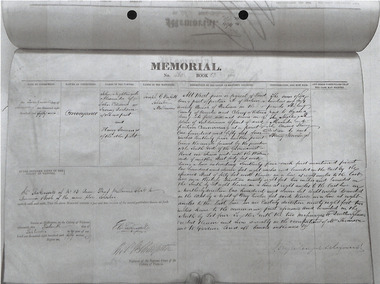 Robin Boyd Foundation
Document, Memorial book
This is an extract of a Memorial book regarding a conveyance of land in Prahran on 16 September 1857. It is very difficult to read and this information may be incorrect. Names on it look like John Nightingale Alexander, John Edward, Irving Dickson and Henry Jennings.Photocopy -
Bendigo Historical Society Inc.
Document - Goornong Cemetery Headstones, August 1989
On 20th September 1878 land was gazetted for the purposes of a cemetery in the township of Goornong (Government Gazette, No. 53, 10th June 1881). The first burial occurred in the Goornong Cemetery on 4th August 1884. The site is known as Goornong Public Cemetery.Goornong Cemetery Headstones Research by Allan Llewellynhistory, bendigo, allan llewellyn collection, goornong cemetery -
 Kew Historical Society Inc
Photograph - Aerial View of East Kew, c.1930
The Municipality of Kew was proclaimed in 1860. This eastern section of Kew was settled from the 1850s with all land sold in the vicinity by 1851. The original large estates were further subdivided in the second half of the 19th and in the first decades of the 20th centuries.Early aerial photograph of KewFramed aerial photograph of that part of Kew in which is located Genazzano FCJ, the Kew Reservoir, and the retail nurseries of Bennett’s and Rimington's.genazzano fcj, kew reservoir, rimington's nurseries, bennett's nursery, cotham road, mont victor road (kew) -
 Kew Historical Society Inc
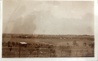
Photograph - Yarra Valley at Kew, 1918
During the nineteenth century, the land abutting the south side of the Yarra in Kew was devoted to dairy farming. In the twentieth century, before and after the construction of the Eastern Freeway, much of this low-lying area was used as golf courses and public parks.View of the farmland in the Yarra Valley at what is believed to be East Kew in 1918. Verso: "Willsmere / East Kew? / 1918"yarra river, yarra valley -
 Kew Historical Society Inc
Photograph - Yarra Valley at Kew, 1912
During the nineteenth century, the land abutting the south side of the Yarra in Kew was devoted to dairy farming. In the twentieth century, before and after the construction of the Eastern Freeway, much of this low-lying area was used as golf courses and public parks.Real-photo postcard of the farmland in the Yarra Valley in what is believed to be North Kew in 1912. Verso: "Willsmere / East Kew / 1912"yarra river, yarra valley, farming -- kew (vic.) -
 Port Fairy Historical Society Museum and Archives
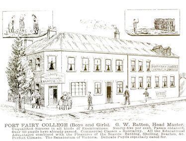
Photograph - Lithograph
This card was probably used as an advertisement. (The Stag built 1848-1853.Land was purchased from Atkinson to build a licensed premises, it later became a boarding house also a boarding school now is used mainly as accommodation and also a Restaurant )Black and white photograph of a drawing of Seacombe House as Port Fairy College with large descriptionPort Fairy College (Boys and Girls) G.W.Ratten Headmaster. I qualified success in all kinds of examinations. Ninety five per cent passes obtained. Over 100 pupils already passed. Commercial classes a speciality. All the educational advantages combined with the pleasures of the seaside, bathing, shelling, beaches & c. Perfect climate. The Sanatorium of Victoria. Delicate pupils especially cared forhotel, stag, seacombe, inn, boarding school, sackville street, cox street -
 Vision Australia
Administrative record - Text, Royal Victorian Institute for the Blind annual report 108th 1973-1974, 1970-1971
Articles in the annual report include: the possible acquisition of land at Burwood by the Government for a teacher college, photos of a trip to Falls Creek by students, the success of the only vocationally orientated residential centre for blind adults and the introduction of E.J. Hanlon as President.1 printed volume with photographsroyal victorian institute for the blind, annual reports -
 Whitehorse Historical Society Inc.
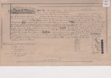
Document, Batman's "Melbourne" Deed, 6 June 1835
Batman's "Melbourne" Deed facsimile of the original held in the the Public Library of Victoria.non-fictionBatman's "Melbourne" Deed facsimile of the original held in the the Public Library of Victoria.aborigines, melbourne, batman john -
 Sunbury Family History and Heritage Society Inc.
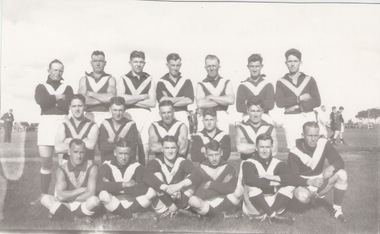
Photograph, Sunbury Football team, c1940 - 1950s
IT is a photograph of the Sunbury Football team possibly taken in the 1940-1950s decades when the matches were played on land bounded by Shields, Evans, Harker and O'Shanassy Streets. A football team was formed in the early 1890s and in 1892 was known as 'The Swifts'.A non- digital black and white photograph of a football team.football, australian rules football, sunbury football club -
 Sunbury Family History and Heritage Society Inc.
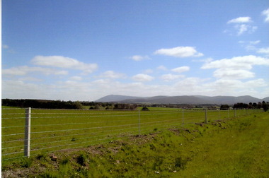
Photograph, Rosa McCall, September 2014
The countryside in this photograph was completely burnt out in February when a severe grassfire raged across the land in February 2024. This is a photograph of the same area taken in the following September 2024 after welcome rain brought growth back on the paddocks.A coloured digital photograph of a green landscape with hills in the background.springtime, grassfires, riddell road, riddells creek