Showing 11127 items
matching planning
-
 Bendigo Historical Society Inc.
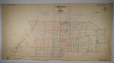
Map - PARISH OF CAMPASPE, November 1880
Map: Parish of Campaspe, County of Rodney. Parish plan G.H.H. Smith Draughtsman August 1880 Examined J.A. Morrison 7.10.80 Photo- Lithographed J. Noone. 1.11.80 Written in green " Cancelled 16.2.66."map, rodney, parish plan, campaspe -
 Lakes Entrance Historical Society
Book, Dept of Natural Resources and Environment Victoria Publisher, Heritage Rivers and Natural Catchment Areas Vol 3, 1997
Draft Management Plans prepared under the Heritage Rivers Act set out the proposed basis for future management of Heritage Rivers and Natural Catchment Areas. Gippsland catchments are significant for the essential undisturbed conditionISBN 0730667936environment, waterways -
Clunes Museum
Document - PLAN, CONSERVATION MANAGEMENT PLAN, UNKNOWN
FINAL DRAFT OF CONSERVATION MANAGEMENT PLAN NOVEMBER 2018 FOR CLUNES FREE LIBRARY TEMPLETON STREET. FOLDER INCLUDES HISTORY OF CLUNES TOWNSHIP. THE BURRA CHARTER, HISTORY OF MECANICS INSTITUTE (FREE LENDING LIBRARY)conservation managment plan, free library -
Port Melbourne Historical & Preservation Society
Photograph - Main drain reconstruction, Cruikshank Street, Port Melbourne, Outfall Timber Drain Reconstruction, 23 Aug 2004
Photographs & plans supplied by Melbourne water of Cruikshank Street main drain reconstruction of bay outfall. 2004 .01 19x25 colour photo of clear spanning footing .02 19x25 colour photo of outer edge of drain .03 19x25 colour photo of top deck of drain .04 19x25 colour photo of excavation .05 - .08 19x25 colour photo of excavation of drain .09 - .12 colour photo of excavation of drain .13 - .14 22x33 colour photo of plan of area .15 - .17 39x53 drawn plan of area surrounding .18 - .19 39x53 Cruickshank St main drain reconstruction .20 Initial e-mail letter regarding drain (3-8-04) .21 Business card, Melbourne Water's Paul Balassomeengineering - canals and drainage, cruickshank street -
Melbourne Tram Museum
Newspaper, The Herald, “New trains, trams hope”, 5/10/1971 12:00:00 AM
Newspaper clipping titled: “New trains, trams hope” – Herald Tues 5/10/71 Photo and text of new tram Experimental new colours, orange, yellow, green Passengers will board through the front door and leave through the centre exit. Driver separated from passengers by a low bulkhead and rails, same style as buses. Conductor will be seated at front entrance. Trams will be heated. Acting chairman of Tramways Board, F D Snell said plans for new trams were complete. “Ready to go as soon as we get the money”. Tram fleet of 700 is planned to be replaced by 600 of improved version. About 900 new trams will be needed by 1985 according to Metropolitan Transport Plan. Each new tram is expected to cost about $65,000.trams, tramways, new trams, livery, metropolitan transport plan, prototype tramcar, 1041, tram 1041 -
 Melbourne Tram Museum
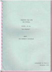
Document - Report, State Co-ordination Council of Vic, "Transport Plan 1978 for Victoria", Dec. 1978
Reports - "Transport Plan 1978 for Victoria" Draft for Community Discussion - Released December 1978. .1 - Vol 1 - "The Strategy" - 48 pages, comb bound with green card coves. Looks at issues and policies in general, metro and non metro, transport policies and basic strategy. .2 - Vol 2 - "The five year plan" - 52 pages, comb bound with manila card covers with two fold out plans, looking at funding, a work program, projects and a bibliography for the three volumes. .3 - Vol 3 - "Basic Transport Data" - 108 pages, comb bound with blue card covers, with many tables and figures, looking at various demographics, metrics, including historical background, transport administration, existing transport system, travel characteristics and forecasts.trams, tramways, public transport, road transport, melbourne -
 Bendigo Historical Society Inc.
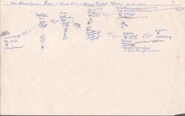
Document - MINING REPORTS - CALEB THOMAS PLANS
(a) Copy of Caleb Thomas Plan - Sheet No VI (774) on the New Chum Line dated 4/12/1885. Plan shows the new St Mungo, Duchess Tribute, South Devonshire, Alberts Shaft, Duchess of Edinburgh, United Devonshire (later W. V. Devonshire), Princess Alexandra (later The United Devonshire) and the Ext'd St Mungo. (b) Sheet No VA (775) dated 30/5/1885. Eaglehawk District. Mines mentioned are: Phoenix Coy, Unicorn Coy Lease, Unicorn Shaft, Sth St Mungo, St Mungo Coy and the Lady Barkly. Also some numbered, unnamed shafts. Plans mentions shaft number, no of compartments and distance in yards and feet between each mine. Document is part of the Albert Richardson Collection. document, gold, mining reports, mining reports, caleb thomas plans, st mungo, duchess tribute, south devonshire, alberts shaft, duchess of edinburgh, united devonshire (later w. v. devonshire), princess alexandra (later the united devonshire), ext'd st mungo, phoenix coy, unicorn co lease, unicorn shaft, sth st mungo, st mungo coy, lady barkly -
Melbourne Tram Museum
Document, Smart Passengers Inc, "Transport Plan - An Alternative Option - 2010 - 2020 Plan", 2009
Document published by Smart Passengers c2010, titled "Transport Plan - An Alternative Option - 2010 - 2020 Plan" a response to the 2008 Victorian Transport Plan, looks at projects that could improve public transport - train, tram and bus for Melbourne. Has a Table of Contents. Includes comments on policies, Docklands tram depot, inner city trams, rail capacity upgrades, bus interchanges, 2020 Train timetable and Flinders St station platform issues. Includes a Glossary of terms. Signed by Michael Angelico as President. The organisation website is no longer active.Demonstrates a privately produced planning document for Melbourne's public transport.Document - book - 32 A4 pages, centre stapled, full colour. Has an A5 errata.trams, tramways, melbourne, public transport, tram, rail, buses, smart passengers -
 Kiewa Valley Historical Society
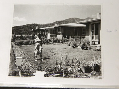
Folder - Early Photos of Mt Beauty
Mt Beauty township was built during the 1950's to house the employees of the State Electricity Commission working on the Kiewa Hydro Electric Scheme. After the completion of the Kiewa Hydro Electric Scheme many houses were sold and the public buildings handed over to the Alpine Shire. Mt Beauty has always been a tourist destination especially with its proximity to the ski fields at Falls Creek.This folder contains many early photos of Mt Beauty showing the construction town during its development during the Kiewa Hydro Electric Scheme and its early days of tourism. A3 size black plastic folder with clear plastic sleeves holding early black & white photos of Mt Beauty township. Also included are: 1. 3 foolscap pages -Nov., 1953 Kiewa Hydro-Electric Scheme Progress. 2. SECV Drawing Plan (No. K6242) of Mt Beauty House - 3 angles and floor plan, English Pre-cut Type 3B.ILA with note that all houses with prefix 3B are similar. 3. Orange, black and white pamphlet "Welcome to Kiewa" 4. Tourist postcard 'fold-up' of 11 postcards "Mt Beauty and the Kiewa Scheme, Victoria 5. Drawing Plan of 'Mt Beauty Housing. Use of Prefabricated Cubicles for Houses. Type C.1 6. Drawing Plan of 'Kiewa Scheme Mt Beauty Housing Type "G". 7. 5 pages on "Twelve Tips on Caring for Old Buildings 8. Booklet advertising Mt Beauty housing for sale including activities available in the area. (1960's) 9. List of Photos from SECV held by KVHS Some photos have handwritten labels mt beauty. secv. kiewa hydro electric scheme.tourism. housing. construction town. falls creek. -
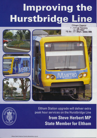 Eltham District Historical Society Inc
Folder, Hurstbridge Line Upgrade, 2010
Correspondence and information from the State Government about the Hurstbridge Line upgrade 2010. Also includes newspaper articles, Nillumbik Shire Council minutes report, map and contextual information regarding the Eltham Major Activity Centre structure Plan 2009. The main area of concern was the plan to reconfigue the Eltham stabling yard.23 documents, 62 pages of news clippings, photocopies and colour political fliersHG Folders 108 and 115harry gilham collection, railway line construction, hurstbridge line, hurstbridge railway line, eltham railway station, eltham station carpark, train stabling yard -
Whitehorse Historical Society Inc.
Map, Yarran Dheran Charts, 1974
Charts relating to the formation of Yarran DheranRolled charts of various dimensionsnon-fictionCharts relating to the formation of Yarran Dheranyarran dheran, yarran dheran advisory committee, thompson paul -
Tarnagulla History Archive
Set of Maps (Mining & Local Area), various
David Gordon Collection. A set of mining documents, maps and plans: 1. Dunolly Deep Leads - showing location and names of deep lead gold deposits in region around Dunolly including at Tarnagulla and Newbridge. Geological Survey of Victoria, Department of Minerals and Energy. Bulletin No. 62, Map No. 4 Dunolly (770 x 485 mm). 2. Poseidon Lead (Facsimile) 3. Nick O Time Lead (Facsimile) 4. Happy Go Lucky Mine prospectus and plan (colour copy) 5. Jones Creek GM Co. (Raven & Gourlay's) Waanyarra - Prospectus (colour copy) 6. Poseidon Area Plan (colour copy) and Poseidon Area map (B&W copy). 7. Cross-section diagram of Spread Eagle Reef 8. New Birthday Gold Mine - area map (colour copy) and mine cross-section ( (colour copy). 9. Cross section of Poverty Reef, by Department of Mines (B&W copy, 2 parts on A2 paper) 10. Time-Lease Graph for Watts Reef, Specimen Reef, Stony Reef, Poverty Reef (second page in detail), created by Eric WIlkinson for Ref Mining NL, 1995 11. 1859 Plan of the Gold Workings & Township of Sandy Creek, Shewing the Mining Leases, Extended Claims & Machinery by R.J. McMillan, Mining Surveyor (B&W copy) 12. Longitundinal and Transverse Vertical Sections of Poverty Reef, Sandy Creek 1859, by R.J. McMillan, Mining Surveyor (B&W copy) 13. Tarnagulla Locality Plan (B&W copy) 14. Universal Grid Reference Map (Topographic) for Laanecoorie North (2 copies) 15. Universal Grid Reference Map (Topographic) for Inglewood South 16. Poverty Reef, Plan showing shafts and early tenements, created by Eric WIlkinson for Ref Mining NL, 1995 17. Locality Map of mining leases in Tarnagulla 18. Plan and Elevation of part of Poverty Reef, Sandy Creek, showing the claims and positions of the shaft. by R.J. McMillan, Mining Surveyor (Facsimile, composed of taped together components) 19.Plan and Elevation of part of Poverty Reef, Sandy Creek, showing the claims and positions of the shaft. by R.J. McMillan, Mining Surveyor (Facsimile, composed of taped together components) -
Potter Farm Collections (RMIT Hamilton)
Video recording, Richard Keddie, Potter Farmland Plan Video
Educational workshops were held as part of the Potter Farmland Plan Project for participating farmers and the community.These videos demonstrate the community participation and teaching/learning styles that were an integral part of the project. They also demonstrate agricultural extension programs that were typical in the 1980'sBeta Film 2 reels No 31 & 32 Farmers Workshop Duration: 45 min. Shot 20/11/1989 agriculture, potter farmland plan, agricultural education, rural community, western victoria -
Glen Eira Historical Society
Plan - St James Parade, 12, Elsternwick
Hand drawn pencil plan of 12 St. James Parade, Elsternwick, unknown author and undated.st. james parade, elsternwick, plans -
Mission to Seafarers Victoria
Letter - Correspondence, 02/02/1951
This letter contains news of mutual friends. Allan plans to leave London for a few months in Oslo.Quinn CollectionA four-page letter written in green ink on one sheet of buff coloured paper folded in book form (0858.a) headed London and dated 02/02/51. Letter is from Allan to his mother. No envelope has been found.letters-from-abroad, allan quinn, london, pat charlton, mr hayes -
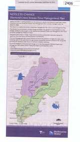 Greensborough Historical Society
Newspaper Clipping, Diamond Creek stream flow management plan, 30/09/2015
In this Public Notice, Melbourne Water seeks feedback on the Diamond Creek Stream Flow Management Plan.News clipping, black text, colour map.diamond creek stream flow management plan, melbourne water. -
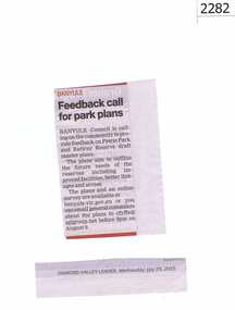 Greensborough Historical Society
Newspaper clipping, Feedback call for park plans, 29/07/2015
Banyule Council asked for community feedback on the draft master plan for Petrie Park and Rattray Reserve.News clipping, black text.montmorency, petrie park, rattray reserve -
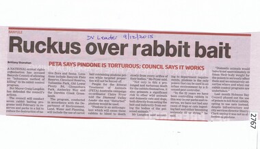 Greensborough Historical Society
Newspaper Clipping, Ruckus over rabbit bait, 09/12/2015
Animal rights group PETA objected to Banyule Council's plan to bait rabbits using Pindone.News clipping, black text, colour image. rabbits, peta, banyule city council -
 Greensborough Historical Society
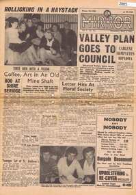
Newspaper, Elliott Provincial newspapers Pty Ltd, Diamond Valley Mirror May 4, 1965, 04/05/1965
Contains article "Valley plan goes to Council", discussing the development of the Plenty Valley, north of Greensborough.Early plan submitted to Diamond Valley Council in 19658 p.greensborough -
 Greensborough Historical Society
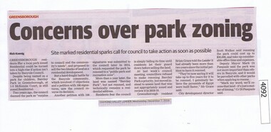
Newspaper Clipping, Diamond Valley Leader, Concerns over park zoning, 07/12/2016
Barclay Park in McKenzie Court Greensborough is still zoned residential with rezoning planned for 2018-19.News clipping, black text. barclay park, mckenzie court greensborough -
 Greensborough Historical Society
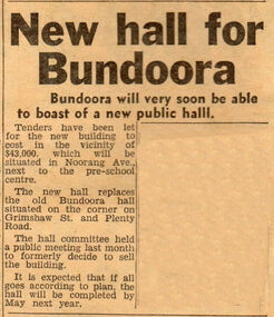
Newspaper Clipping - Digital Image, New hall for Bundoora, 21/11/1967
News of the planned sale of the old Bundoora Hall and building of a new Hall in Noorang Avenue in 1967.Digital copy of newspaper clipping.bundoora public hall, bundoora -
 Whitehorse Historical Society Inc.
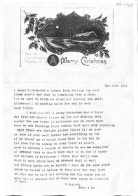
Postcard, Christmas Card from Mary to Cissie, 21/12/1913
Photocopy of Christmas Card from Mary and Emil to Cissienon-fictionPhotocopy of Christmas Card from Mary and Emil to Cissiejackschowsky mary, schwerkolt francesca, jackschowsky emil -
![Vital Connections: Melbourne and its Board of Works 1891-1991 / [by] A.E. Dingle](/media/collectors/550653872162f11fb04854aa/items/5ece65f9f36c2704c4f2b67b/item-media/5ece66eef36c2704c4f2b783/item-fit-380x285.jpg) Kew Historical Society Inc
Kew Historical Society IncBook, A.E. Dingle, Vital Connections: Melbourne and its Board of Works 1891-1991, 1991
Ringwood, Vic. : McPhee Gribble, 1991 432 p. : ill. (some col.), maps, ports. ; 25 cm. non-fictionmelbourne and metropolitan board of works -- history., melbourne (vic.) -- public works -- history., cartography -
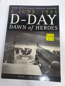 Clayton RSL Sub Branch
soft cover non-fiction book, Arcturus Publishing, 6 June 1944 D-Day Dawn of Heroes, 2004
Tells the story of Operation Overlord, the largest most meticulously planned seaborne invasion in the history of warfare.soft cover non-ficton book -
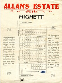 City of Kingston
Pamphlet - Colour, Allan's Estate Highett, 1930s
Sales plan for land in the suburb of Highett, bounded by Spring Road, Highett Road and Worthing Terrace.The developing urban area of Highett within the City of Kingston. This land sale pamphlet illustrates the subdivision of land within the municipality and the changing demographic of the district as new houses are constructed.Colour pamphlet advertising Allan's Estate, Highett. Incorporates a map of the estate bordered by Spring Road, Highett Road and Worthing Terrace.Handwritten in grey pencil on reverse: Allan's Estate / Highett Crossed out in blue pencil on front: Name and address of what appears to be a solicitorhighett, land sales, estate -
 City of Kingston
Pamphlet - Black and white, Stott & Burke, Highland Estate Bentleigh, c.1915
Sales plan for land in the suburb of Bentleigh, along Collins and Ross Streets, bounded by Jasper Road.The developing urban area of Bentleigh within the City of Kingston. This land sale pamphlet illustrates the subdivision of land within the municipality and the changing demographic of the district as new houses are constructed.Black and white pamphlet advertising for private sale the Highland Estate, Bentleigh. Incorporates a map of the estate between Collins St and Ross St, bordered by Japser Road. Handwritten in grey pencil on map: additional subdivisions numbered 15-19 drawn along Ross St Handwritten in grey pencil on map: indecipherable annotations to subdivisions 1, 3 and 14land sales, bentleigh, estate -
Greensborough Historical Society
Leaflet, Road changes: Greensborough and Watsonia March 2019, 2019_03
Outline of proposed changes to the plan for roads around the Old Greensborough Road and Watsonia Station areas1 p. leaflet printed in colour both sides north east link, watsonia station, old greensborough road watsonia -
 Lakes Entrance Historical Society
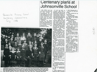
Photograph - Johnsonville State School, 1912 c
Newspaper article outlines activities planned for Johnsonville Primary School Centenary Celebrations July 1986.Black and white photocopy of newspaper article with photograph of twenty two children with teacher William Armstrong of J Primary School Johnsonville Victoriaschools, students -
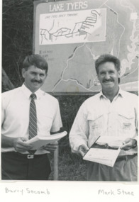 Lakes Entrance Historical Society
Photograph, Lake Tyers Beach Strategy Plan. Lake Tyers Beach progress Association
Launch of Lake Tyers Beach Strategy Plan . Second photo of Joe Taylor at his farewell Black and white photograph of Cr. Barry Secomb (Tambo Shire), Mark Stone(Regional Manager DCE) . Plus second photo of members of Lake Tyers Beach progress Association clubs, township planning -
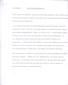 Robin Boyd Foundation
Document - Manuscript, Robin Boyd, Canberra, 1967
Boyd outlines the history of Canberra's design and construction. He argues that Canberra's strength is its planning and axially-based landscaping, but that it lacks the buildings which make the Le Corbusier's Chandigarh interesting. Boyd is highly critical of Chandigarh as an urban environment and concludes that for non-architects, planning and connection to nature is more important than buildings.Original manuscript published as 'Canberra Master Plan: Walter Burley Griffin' in World Architecture 4, John Donat (ed.), Viking Press 1967, pp 202-205.Typewritten (p/copy), quarto, 6 pageswalter burley griffin, canberra, john overall, lake burley griffin, oscar niemeyer, le corbusier, chandigarh, city beautiful, garden city, urban planning, robin boyd, manuscript