Showing 8898 items matching "lake"
-
 Whitehorse Historical Society Inc.
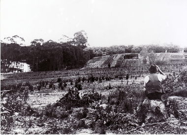
Photograph, Adult Deaf and Dumb Society Farm, c1910
Original photo at Blackburn Lake Education Centre. Dorothy Meagher loaned photo so a print could be made.Black and white photograph of Adult Deaf and Dumb Society's farm in Blackburn.adult deaf and dumb society, meagher, dorothy, blackburn lake education centre -
 Whitehorse Historical Society Inc.
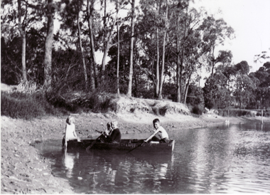
Photograph, Old Dam - Corner of Blackburn and Canterbury Road, c1910
Original photo at Blackburn Lake Education Centre. Dorothy Meagher loaned photo so a print could be made.Black and white photograph of children playing on the dam on the corner of Blackburn and Canterbury Roads, Blackburn. The Bellbird Hospital is now on the site.canterbury road, blackburn, blackburn road, blackburn lake education centre, meagher, dorothy, bellbird private hospital -
 Whitehorse Historical Society Inc.
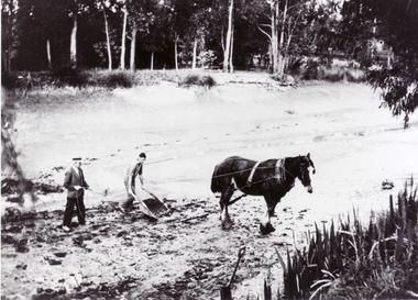
Photograph, Old Dam corner Blackburn and Canterbury Roads, c1910
Original photo at Blackburn Lake Education Centre. Dorothy Meagher loaned photo so a print could be made.Black and white photograph of dam being built on the south west corner of Canterbury and Blackburn Roads, Blackburn. Bellbird Hospital is now on this site.canterbury road, blackburn, blackburn road, blackburn lake education centre, meagher, dorothy, bellbird private hospital -
 Rutherglen Historical Society
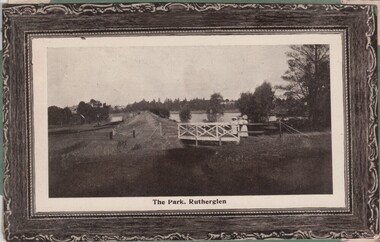
Image, 1900s
Black and white photo shows the weir and Lake King in the Rutherglen Park. The colour photograph is of an ocean liner, the Osterley.Two postcards pasted onto either side of a piece of green cardboard, probably cut from an album. One photo is a black and white photograph. One is in colour.At bottom of black and white photograph: "The Park, Rutherglen" On the top left corner of the colour photograph: "R.M.S. Osterley | 12 129 tons, 14 000 H. Power" rutherglen park, lake king, rms osterley -
 Friends of Ballarat Botanical Gardens History Group
Work on paper - Victoria Park, Ballarat, A Brief History, Unknown
Little has been researched or written about Victoria Park, by comparison with the Ballarat Botanical Gardens and Lake Wendouree.Based on the information given here, the author's conclusion is that Victoria Park is, in many ways, "the poor relation of the Botanical Gardens."2 pages of mainly short paragraphs. p.1 is blank, 2/3 of the page down.Nonejohn garner, doctor john garner, ballarat botanical gardens, friends of ballarat botanical gardens, victoria park, george longley, city night soil, the mulloch heap, trees, 2nd world war, american servicemen., gardens, ballarat, john garner collection -
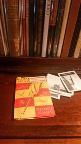 Hymettus Cottage & Garden Ballarat
Photograph Folder, 1956 Olympic Games Kodak photo folder Ballarat, 1956
A Kodak Photograph folder of snapshots of rowing crew images from the 1956 Olympic Games at Lake Wendouree, Ballarat. -
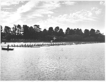 Hymettus Cottage & Garden Ballarat
Photograph, Maiden eights 1948 Ballarat Regatta, 1948
Rare event of eighteen rowing eights lined up for start of race at Ballarat's Lake Wendouree in March 1948.Ballarat Regatta March 1948 Start of eighteen maiden eights won by Wendouree, in ink on verso. -
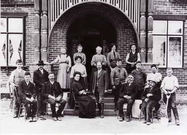 Whitehorse Historical Society Inc.
Photograph - Black and white photograph, Mr & Mrs Abrahams , Deaf Society, c1910
Original photo at Blackburn Lake Education Centre. Dorothy Meagher loaned photo so a print could be made.Black and white photograph of Mr and Mrs Abrahams, Superintendents of the Adult Deaf and Dumb Society at Blackburn. They are in centre of group.abrahams, mr & mrs, adult deaf and dumb society, meagher, dorothy, blackburn lake education centre -
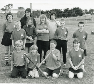 Lakes Entrance Historical Society
Photograph - Swan Reach School, Lakes Post Newspaper, 1993
Taken at the end of 1993 season, photo appeared in Lakes Post newspaper 6 October 1993, page 26.Black and white photograph of nine children and three adults from Swan Reach Primary School Hockey team. Swan Reach Victoriastudents, schools -
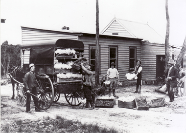 Whitehorse Historical Society Inc.
Photograph - Black and white photograph, Adult Deaf and Dumb Society's Flower Farm, c1910
Original photo at Blackburn Lake Education Centre. Dorothy Meagher loaned photo so a print could be made.Black and white photograph of Adult Deaf and Dumb Society's flower farm at Blackburn about 1910.adult deaf and dumb society, meagher, dorothy, blackburn lake education centre -
Lakes Entrance Historical Society
Article, Mississippi
Some handwriting in ink on cover, Lakes Entrance July 1922, spine has been bound using woolMusic for Mississippi songmusic book -
Lakes Entrance Historical Society
Memorabilia - Lakes Entrance Football Club Port, 13/6/1987
Lakes Entrance Football team bottle of tawny port a memento of win against Orbost 13/6/87Bottle of Port football, mementos -
 Lakes Entrance Historical Society
Photograph, Greencorp Conservation Volunteers at Beechers Holiday units Lakes Entrance Victoria, 1998
Group of seven helped clean up around the stone barge site at New Works Lakes Entrance Victoria Colour photo of international volunteers from Greencorp Conservation. Plus two colour photos of Beechers Holiday units where the volunteers stayedboats and boating, buildings, businesses, accommodation -
 Lakes Entrance Historical Society
Photograph, Michael, Keith and Lionel Carpenter, 1/06/1989 12:00:00 AM
taken at barbeque at Carpenters Camp Park during Carpenter reunion for Entrance Centenary celebration Lakes Entrance VictoriaColour photograph of Michael Keith and Lionel Carpenter genealogy, carpenter family -
 Federation University Historical Collection
Photographs - Colour, Chatham-Holmes Collection: Philip and Elizabeth Chatham on Holiday - America and Canada
Photographs show Philip and Elizabeth Chatham on holiday in America and Canada. Places - Vancouver, Lake Louise, San Franciscochatham-holmes collection, philip chatham, elizabeth chatham, canada, america, lake kouise, san francisco -
 Bendigo Historical Society Inc.
Map - Laminated map of Lake Eppalock at full capacity
John Perry Collection. Laminated copy of map of Lake Eppalock at full capacity. Had highlighter markings of old roads which appear to be still in use. The dam was built by the State Rivers and Water Supply Commission of Victoria. The dam wall height is 45 metres (148 ft) and the main embankment is 1,041 metres (3,415 ft) long. At 100% capacity the dam wall was designed to hold back 304,651 megalitres (6.7014×10¹⁰ imp gal; 8.0480×10¹⁰ US gal) of water. The surface area of Lake Eppalock is 3,011 hectares (7,440 acres) and the catchment area is 2,124 square kilometres (820 sq mi). The controlled spillway is capable of discharging 8,040 cubic metres per second (284,000 cu ft/s). Lake Eppalock supplies both stock and domestic water to the Campaspe irrigation district. It also serves as a water supply to Bendigo and Heathcote and, in more recent times, Ballarat. The lake is a major attraction for those engaging in watersports, with a number of tourist parks and accommodation facilities available. Permissible activities on the lake include high-speed boating, water skiing, sailing, canoeing, fishing and swimming. The lake's water levels were low for approximately eight years between 2002 and 2010 during a prolonged drought, which restricted the amount of recreational activity until rainfall in the latter half of 2010 returned the lake to 100 percent capacity. Built between 1961 and 1964, Lake Eppalock remains the only water storage on the Campaspe River system.map, water, dam, reservoir, eppalock -
 Bendigo Historical Society Inc.
Map - Laminated worksheet - identification of inundated artifacts at Lake Eppalock
John Perry Collection. Laminated copy of worksheet identifying inundated artifacts at Lake Eppalock when at 10% capacity. The dam was built by the State Rivers and Water Supply Commission of Victoria. The dam wall height is 45 metres (148 ft) and the main embankment is 1,041 metres (3,415 ft) long. At 100% capacity the dam wall was designed to hold back 304,651 megalitres (6.7014×10¹⁰ imp gal; 8.0480×10¹⁰ US gal) of water. The surface area of Lake Eppalock is 3,011 hectares (7,440 acres) and the catchment area is 2,124 square kilometres (820 sq mi). The controlled spillway is capable of discharging 8,040 cubic metres per second (284,000 cu ft/s). Lake Eppalock supplies both stock and domestic water to the Campaspe irrigation district. It also serves as a water supply to Bendigo and Heathcote and, in more recent times, Ballarat. The lake is a major attraction for those engaging in watersports, with a number of tourist parks and accommodation facilities available. Permissible activities on the lake include high-speed boating, water skiing, sailing, canoeing, fishing and swimming. The lake's water levels were low for approximately eight years between 2002 and 2010 during a prolonged drought, which restricted the amount of recreational activity until rainfall in the latter half of 2010 returned the lake to 100 percent capacity. Built between 1961 and 1964, Lake Eppalock remains the only water storage on the Campaspe River system.map, artifacts, eppalock, reservoir -
 Bendigo Historical Society Inc.
Map - Black and white map pertaining to Lake Eppalock
John Perry Collection. Laminated copy of map pertaining to Lake Eppalock. Gives details of dwellings, bridges and ford crossings. The dam was built by the State Rivers and Water Supply Commission of Victoria. The dam wall height is 45 metres (148 ft) and the main embankment is 1,041 metres (3,415 ft) long. At 100% capacity the dam wall was designed to hold back 304,651 megalitres (6.7014×10¹⁰ imp gal; 8.0480×10¹⁰ US gal) of water. The surface area of Lake Eppalock is 3,011 hectares (7,440 acres) and the catchment area is 2,124 square kilometres (820 sq mi). The controlled spillway is capable of discharging 8,040 cubic metres per second (284,000 cu ft/s). Lake Eppalock supplies both stock and domestic water to the Campaspe irrigation district. It also serves as a water supply to Bendigo and Heathcote and, in more recent times, Ballarat. The lake is a major attraction for those engaging in watersports, with a number of tourist parks and accommodation facilities available. Permissible activities on the lake include high-speed boating, water skiing, sailing, canoeing, fishing and swimming. The lake's water levels were low for approximately eight years between 2002 and 2010 during a prolonged drought, which restricted the amount of recreational activity until rainfall in the latter half of 2010 returned the lake to 100 percent capacity. Built between 1961 and 1964, Lake Eppalock remains the only water storage on the Campaspe River system.eppalock, map, water, dam, reservoir -
 Bendigo Historical Society Inc.
Map - Map of overlay of lake Eppalock at full capacity. Map 'C'
John Perry collection. Map 'C'. Laminated map of overlay of Lake Eppalock at full capacity. Circa 1951. The dam was built by the State Rivers and Water Supply Commission of Victoria. The dam wall height is 45 metres (148 ft) and the main embankment is 1,041 metres (3,415 ft) long. At 100% capacity the dam wall was designed to hold back 304,651 megalitres (6.7014×10¹⁰ imp gal; 8.0480×10¹⁰ US gal) of water. The surface area of Lake Eppalock is 3,011 hectares (7,440 acres) and the catchment area is 2,124 square kilometres (820 sq mi). The controlled spillway is capable of discharging 8,040 cubic metres per second (284,000 cu ft/s). Lake Eppalock supplies both stock and domestic water to the Campaspe irrigation district. It also serves as a water supply to Bendigo and Heathcote and, in more recent times, Ballarat. The lake is a major attraction for those engaging in watersports, with a number of tourist parks and accommodation facilities available. Permissible activities on the lake include high-speed boating, water skiing, sailing, canoeing, fishing and swimming. The lake's water levels were low for approximately eight years between 2002 and 2010 during a prolonged drought, which restricted the amount of recreational activity until rainfall in the latter half of 2010 returned the lake to 100 percent capacity. Built between 1961 and 1964, Lake Eppalock remains the only water storage on the Campaspe River system.map, water, eppalock, dam, reservoir -
 Bendigo Historical Society Inc.
Map - Laminated map of Lake Eppalock empty. Map 'D'
John Perry Collection. Laminated map of Lake Eppalock empty. Map 'D'. Circa 1951. The dam was built by the State Rivers and Water Supply Commission of Victoria. The dam wall height is 45 metres (148 ft) and the main embankment is 1,041 metres (3,415 ft) long. At 100% capacity the dam wall was designed to hold back 304,651 megalitres (6.7014×10¹⁰ imp gal; 8.0480×10¹⁰ US gal) of water. The surface area of Lake Eppalock is 3,011 hectares (7,440 acres) and the catchment area is 2,124 square kilometres (820 sq mi). The controlled spillway is capable of discharging 8,040 cubic metres per second (284,000 cu ft/s). Lake Eppalock supplies both stock and domestic water to the Campaspe irrigation district. It also serves as a water supply to Bendigo and Heathcote and, in more recent times, Ballarat. The lake is a major attraction for those engaging in watersports, with a number of tourist parks and accommodation facilities available. Permissible activities on the lake include high-speed boating, water skiing, sailing, canoeing, fishing and swimming. The lake's water levels were low for approximately eight years between 2002 and 2010 during a prolonged drought, which restricted the amount of recreational activity until rainfall in the latter half of 2010 returned the lake to 100 percent capacity. Built between 1961 and 1964, Lake Eppalock remains the only water storage on the Campaspe River system.map, water, dam, reservoir, eppalock -
 Bendigo Historical Society Inc.
Document - Legend to maps A, B and C for Lake Eppalock
John Perry Collection. Laminated 'legend' for Maps A, B and C for Lake Eppalock also in this collection. Black and White definitions and descriptions of objects and markers found on maps. Circa 1951. The dam was built by the State Rivers and Water Supply Commission of Victoria. The dam wall height is 45 metres (148 ft) and the main embankment is 1,041 metres (3,415 ft) long. At 100% capacity the dam wall was designed to hold back 304,651 megalitres (6.7014×10¹⁰ imp gal; 8.0480×10¹⁰ US gal) of water. The surface area of Lake Eppalock is 3,011 hectares (7,440 acres) and the catchment area is 2,124 square kilometres (820 sq mi). The controlled spillway is capable of discharging 8,040 cubic metres per second (284,000 cu ft/s). Lake Eppalock supplies both stock and domestic water to the Campaspe irrigation district. It also serves as a water supply to Bendigo and Heathcote and, in more recent times, Ballarat. The lake is a major attraction for those engaging in watersports, with a number of tourist parks and accommodation facilities available. Permissible activities on the lake include high-speed boating, water skiing, sailing, canoeing, fishing and swimming. The lake's water levels were low for approximately eight years between 2002 and 2010 during a prolonged drought, which restricted the amount of recreational activity until rainfall in the latter half of 2010 returned the lake to 100 percent capacity. Built between 1961 and 1964, Lake Eppalock remains the only water storage on the Campaspe River system.map, water, dam, reservoir, eppalock -
 Bendigo Historical Society Inc.
Map - Black and White map. Outline of Lake Eppalock. Map 'B'
John Perry Collection. Laminated copy black and white map. Map 'B'. Outline of Lake Eppalcok, overlayed on map. Circa 1951. The dam was built by the State Rivers and Water Supply Commission of Victoria. The dam wall height is 45 metres (148 ft) and the main embankment is 1,041 metres (3,415 ft) long. At 100% capacity the dam wall was designed to hold back 304,651 megalitres (6.7014×10¹⁰ imp gal; 8.0480×10¹⁰ US gal) of water. The surface area of Lake Eppalock is 3,011 hectares (7,440 acres) and the catchment area is 2,124 square kilometres (820 sq mi). The controlled spillway is capable of discharging 8,040 cubic metres per second (284,000 cu ft/s). Lake Eppalock supplies both stock and domestic water to the Campaspe irrigation district. It also serves as a water supply to Bendigo and Heathcote and, in more recent times, Ballarat. The lake is a major attraction for those engaging in watersports, with a number of tourist parks and accommodation facilities available. Permissible activities on the lake include high-speed boating, water skiing, sailing, canoeing, fishing and swimming. The lake's water levels were low for approximately eight years between 2002 and 2010 during a prolonged drought, which restricted the amount of recreational activity until rainfall in the latter half of 2010 returned the lake to 100 percent capacity. Built between 1961 and 1964, Lake Eppalock remains the only water storage on the Campaspe River system.map, water, dam, reservoir, eppalock -
 Bendigo Historical Society Inc.
Map - Black and white map pertaining to Lake Eppalock
John Perry Collection. Laminated copy of map relating to Lake Eppalock. Lists dwellings, ford crossings and bridges. The dam was built by the State Rivers and Water Supply Commission of Victoria. The dam wall height is 45 metres (148 ft) and the main embankment is 1,041 metres (3,415 ft) long. At 100% capacity the dam wall was designed to hold back 304,651 megalitres (6.7014×10¹⁰ imp gal; 8.0480×10¹⁰ US gal) of water. The surface area of Lake Eppalock is 3,011 hectares (7,440 acres) and the catchment area is 2,124 square kilometres (820 sq mi). The controlled spillway is capable of discharging 8,040 cubic metres per second (284,000 cu ft/s). Lake Eppalock supplies both stock and domestic water to the Campaspe irrigation district. It also serves as a water supply to Bendigo and Heathcote and, in more recent times, Ballarat. The lake is a major attraction for those engaging in watersports, with a number of tourist parks and accommodation facilities available. Permissible activities on the lake include high-speed boating, water skiing, sailing, canoeing, fishing and swimming. The lake's water levels were low for approximately eight years between 2002 and 2010 during a prolonged drought, which restricted the amount of recreational activity until rainfall in the latter half of 2010 returned the lake to 100 percent capacity. Built between 1961 and 1964, Lake Eppalock remains the only water storage on the Campaspe River system.map, water, dam, reservoir, eppalock -
 Bendigo Historical Society Inc.
Map - General view of area of proposed construction of Lake Eppalock. Map 'A'
John Perry Collection. Laminated map of proposed construction of Lake Eppalock. Map 'A'. Black and white map in laminate. Circa 1951. The dam was built by the State Rivers and Water Supply Commission of Victoria. The dam wall height is 45 metres (148 ft) and the main embankment is 1,041 metres (3,415 ft) long. At 100% capacity the dam wall was designed to hold back 304,651 megalitres (6.7014×10¹⁰ imp gal; 8.0480×10¹⁰ US gal) of water. The surface area of Lake Eppalock is 3,011 hectares (7,440 acres) and the catchment area is 2,124 square kilometres (820 sq mi). The controlled spillway is capable of discharging 8,040 cubic metres per second (284,000 cu ft/s). Lake Eppalock supplies both stock and domestic water to the Campaspe irrigation district. It also serves as a water supply to Bendigo and Heathcote and, in more recent times, Ballarat. The lake is a major attraction for those engaging in watersports, with a number of tourist parks and accommodation facilities available. Permissible activities on the lake include high-speed boating, water skiing, sailing, canoeing, fishing and swimming. The lake's water levels were low for approximately eight years between 2002 and 2010 during a prolonged drought, which restricted the amount of recreational activity until rainfall in the latter half of 2010 returned the lake to 100 percent capacity. Built between 1961 and 1964, Lake Eppalock remains the only water storage on the Campaspe River system.map, dam, water, weir, eppalock -
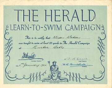 Federation University Historical Collection
Certificate, Herald Learn-To-Swim Campaign Certificate, 1956, 1956
Alison Watson was the daughter of Peg and Harry Watson of Cromie Street Murtoa and would have been seven years old when this certificate was granted at the Murtoa Swimming Baths. The Baths were adjacent to Lake Marma and filled with water from the lake. There was a wooden pontoon in the centre of the pool which was removed for swimming competitions. Alison's father was the swimming coach at the time - 1956.A rectangular light blue/green certificate with navy blue writing with letters highlighted with white accents. There is an illustration with Neptune, a mermaid, and a dolphin at the bottom centre with scrolls on either side.The applicant (Alison Watson); the location (Murtoa Baths); the date(6th January 1956) the local president (N.T. McQueen) and the Secretary (F.C. Bradshaw) are hand written.certificate, learn to swim, learn to swim certificate, alison watson, murtoa, murtoa swimming baths, swimming baths, swimming pools -
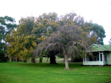 Mortlake and District Historical Society
Queen Victoria's Oak Tree
This magnificent English oak tree is located at Tea Tree Lake park in Mortlake. This park was formerly the Botanic Gardens which were developed on what had been swamp land. An artificial lake was created there in 1988 as a Bi-Centenary project.The tree is located adjacent to the historic Montgomery Pavillion and was planted on the occasion of Her Majesty Queen Victoria's birthday on 24th May 1883. An outstanding tree, planted to commemorate a much-revered Queen in an historically-significant Botanic Gardens (now much altered). A very old oak tree planted 1883. queen victoria, mortlake, mortlake botanic gardens, tea tree lake, montgomery pavillion -
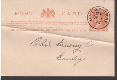 Bendigo Historical Society Inc.
Postcard - COHN BROTHERS COLLECTION: PRE-PAID POSTCARD DATED 1896
Pre paid Victorian State postcard PO cancel stamp 22H Dated December 7th 1896 handwritten addressed to Cohn's Brewery Co Bendigo. Same day receival PO stamp with handwritten Dear Sir, My preferred address is Lake Tyers Hotel, Lake Tyers. Henry Algew Gippsland.bendigo, industry, cohn bros brewery -
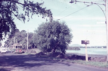 Ballarat Tramway Museum
Slide - 35mm slide/s, Keith Caldwell, c1963
Yields information about tram 26 and Wendouree Parade and the nearby Lake Wendouree near St Aidans Drive.Agfa colour slide, white cardboard mount, photo by Keith Caldwell during c1963 of: Tram 26 in Wendouree Parade approaching St Aidans Drive from the depot end. The tram has the destination of Mt Pleasant and has adverts for Twin Lakes and Briquettes on the front dash panel. Lake Wendouree is in the background.tramways, trams, wendouree parade, st aidans drive, lake wendouree, tram 26 -
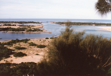 Lakes Entrance Historical Society
Photograph - The Entrance, 1995c
Second colour copy as 01601-1 portrait size 15 x 10Colour photograph of the entrance from Bass Strait to the Gippsland Lakes. It shows buildings on Bullock Island including Peck's factory. Western end of Bullock Island and area below Jemmys Point, both made during dredging operations over many years. Two fishing boats in entrance. Lakes Entrance Victoria room display, waterways, topography -
 Lakes Entrance Historical Society
Photograph - Kawar, 1920c
Built by John Herbert Syme in about 1911 to 1912.Black and white photograph of Kawar the home built on Fraser Island, Gippsland Lakes. It shows a substantial weatherboard dwelling, built about two metres above ground level, corrugated iron roof, veranda all around, steps leading to veranda. Man in top hat at bottom of steps. Lakes Entrance Victoria islands, houses