Showing 10954 items matching " land"
-
 City of Greater Geelong
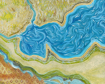
Painting - Acrylic on Canvas, Dr Jenny Murray-Jones, Corio, 2019
This work is all about Country for Wadawurrung people, the lay of the land, food crops and the abundant recourses which sustains the Wadawurrung people. Again I have used traditional patterns and made reference to Wallaby Grass and Murnong staple foods for Wadawurrung people.Painting of river and grassland from above. Green, blue and brown used.On back left bottom corner - J.Murray.Jones 2019 'Corio'corio, wadawurrung, murnong -
 Eltham District Historical Society Inc
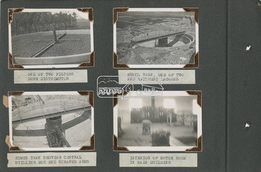
Album - Photograph Album, Alan Gardiner, M.M.B.W Braeside Sewage Treatment Plant Construction, 1939
In April 1928 the MMBW had the land and the plans for what they were to construct but the timing of the actual building did not proceed as planned. Before the construction could commence the Great Depression of the 1930s intervened forcing the shelving of its plans. The new owners then offered the land for lease resulting in Frederick Werrett taking the opportunity to take up the land he formerly owned to continue his market gardening activities of growing potatoes, onions and other crops. The land and improvements made by Syme were leased in 1929 to Harry Telford a trainer from New South Wales. Phar Lap grazed there for a short time. [9] However the population of Melbourne continued to grow and the need for a sewerage treatment plant did not go away. In 1939 when the effects of the Depression had dissipated work on the Sewerage Effluent Treatment Plant commenced and the following year in October the Premier of the State, Albert Dunstan, officially commissioned it. The Sewerage Effluent Treatment Plant at Braeside served the communities of south-east Melbourne for thirty five years until 1975. In that year all the sewers that entered the Braeside plant were diverted to the South Eastern Trunk Sewer complex at Carrum.[10] In 1982 the chairman of the MMBW at that time, Alan Croxford, announced that a substantial part of the property at Braeside would be administered by the Parks and Gardens section of MMBW as a public park. Subsequently the responsibilities were transferred to Parks Victoria, the situation that exists today. It is known as “Braeside Park” now. [Source: Sewerage Treatment Plant at Braeside, Kingston Local History, https://localhistory.kingston.vic.gov.au/articles/407]alan gardiner collection, 1939, braeside sewage treatment plant, construction, melbourne metropolitan board of works, mmbw -
 Eltham District Historical Society Inc
Album - Photograph Album, Alan Gardiner, M.M.B.W Braeside Sewage Treatment Plant Construction, 1939
In April 1928 the MMBW had the land and the plans for what they were to construct but the timing of the actual building did not proceed as planned. Before the construction could commence the Great Depression of the 1930s intervened forcing the shelving of its plans. The new owners then offered the land for lease resulting in Frederick Werrett taking the opportunity to take up the land he formerly owned to continue his market gardening activities of growing potatoes, onions and other crops. The land and improvements made by Syme were leased in 1929 to Harry Telford a trainer from New South Wales. Phar Lap grazed there for a short time. [9] However the population of Melbourne continued to grow and the need for a sewerage treatment plant did not go away. In 1939 when the effects of the Depression had dissipated work on the Sewerage Effluent Treatment Plant commenced and the following year in October the Premier of the State, Albert Dunstan, officially commissioned it. The Sewerage Effluent Treatment Plant at Braeside served the communities of south-east Melbourne for thirty five years until 1975. In that year all the sewers that entered the Braeside plant were diverted to the South Eastern Trunk Sewer complex at Carrum.[10] In 1982 the chairman of the MMBW at that time, Alan Croxford, announced that a substantial part of the property at Braeside would be administered by the Parks and Gardens section of MMBW as a public park. Subsequently the responsibilities were transferred to Parks Victoria, the situation that exists today. It is known as “Braeside Park” now. [Source: Sewerage Treatment Plant at Braeside, Kingston Local History, https://localhistory.kingston.vic.gov.au/articles/407]alan gardiner collection, 1939, braeside sewage treatment plant, construction, melbourne metropolitan board of works, mmbw -
 Glen Eira Historical Society
Document - LAND SUBDIVISIONS 1880-1938
This file contains various subdivisions’ advertising flyers and cards. 1/Advertising announcement for auction sale of land (15 lots) at Glenhuntly Tram Terminus, to be held on 29/03/1924. Verso is map of the area (21.5cm x 29cm) 2/Advertising announcement for Trustees’ Auction sale of corner shop sites at Caulfield South near Glenhuntly Road and Hawthorn Roads, 15/11/1927 (21cm x 31cm) 3/Advertising pamphlet (A3) for auction of Cantala Estate, East St. Kilda (32 allotments), between Dandenong, Waiora, and Alma Roads, 21/05/1938 (15.5cm x 28.5cm) 4/Seven advertising postcards relating to auctions of land in Caulfield and Elsternwick. Only one (10 December 1881) with a year on it. (Each 13.5cm x 9cm) 5/Four more advertising postcards relating to auctions of land in Caulfield. One is dated 31/11/1880(?); another 09/02/1905. A third has no date. A fourth postcard is a map of allotments between Orrong, Kooyong, Seymour and Alison Roads, Caulfield, no date (each 13.5cm x 9cm) 6/Large advertising poster (41cm x 52.5cm) for ‘Carnegie Land Sale’ auction of the Egan Estate (near Carnegie Railway Station) on 12 April, no year given, but appears to be circa1900 7/‘Riddell Estate – Plan of Subdivision – Parish of Prahran’ mounted map, no date, probably c. 1900 (16cm x 21cm)auctions, house auctions, land subdivision, land development, subdivisions, caulfield, land subdivisions, east st. kilda, glenhuntly, carnegie, map, ‘new glenhuntly tram terminus estate’, ‘cantala estate’, ‘strathnaver estate’, ‘range estate’, ‘egan estate’, ‘riddell estate’ -
 Kew Historical Society Inc
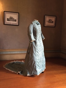
Accessory - Cream Silk & Lace Parasol, c.1900
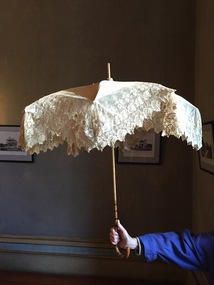
Joseph Butterworth COOMBS (1842-1901), was an accountant who founded a successful mercantile trading company. At the time of his marriage to Caroline Mary MICHEL in 1869, Coombs had already purchased ten acres of Studley Park. The acreage included land on the west of Fenwick Street that extended along lower Stawell Street to the corner of Yarra Street, all of it connected directly to the Yarra environs. A right of way to Studley Park Road was on the title, though Coombs went on to purchase more land, some of which faced Studley Park Road. In addition to owning the Studley Park acreage, Coombs later acquired 1,201 acres of land abutting the Acheron River. While retaining the Kew property he became a Taggerty Councillor and was Shire President for a time. J.B. Coombs died at Acheron Station in 1901 (aged 59 years). A few months after, tenders were called to repair the Kew dwelling, the Fenwick Street property now appearing in records with the name ‘Hope Mansell’. Caroline Coombs remained at Hope Mansell until she died in 1924, survived by three sons and five daughters. Not long after her death, advertisements appeared for the sale of the Studley Park land. The sale seems to have been a mechanism for distribution of the Estate, as the following year the original ten acre holding was transferred to members of the family. The eldest daughter Mabel married William Younger who, with his brother Alexander, developed Younger and Mackie Courts, both south of Studley Park Road. [Research: Kerry Fairbank]In 1961, the granddaughter of Joseph and Caroline Coombs, Mabel Isola (Younger) Grattan, donated ten 19th century dresses and parasols to the Kew Historical Society. The costumes, now known as the 'Coombs Collection', are the earliest recorded items of clothing to enter the Society's collection. Each of the items in the Coombs Collection, of which this item forms a part, is historically, aesthetically and socially significant. As a collection, the costumes includes outstanding examples of morning wear, day dresses, wedding dresses, and clothing accessories, providing evidence of outstanding dressmaker skills in Victoria during the mid to late Victorian period. One of a pair of cream silk parasols, each bordered by overlapping bands of beige lace. The underlying structure and mechanism includes a bent cane handle and black metal expanding spokes. The lace borders are layered to create an overlapping fringe. The high-domed umbrellas may have been created for a bridal party."Coombs Collection"coombs collection, clothing accessories, parasols -
 Kew Historical Society Inc
Accessory - Cream Silk & Lace Parasol, c. 1900
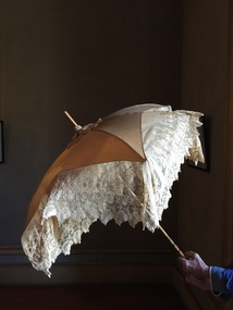
Joseph Butterworth COOMBS (1842-1901), was an accountant who founded a successful mercantile trading company. At the time of his marriage to Caroline Mary MICHEL in 1869, Coombs had already purchased ten acres of Studley Park. The acreage included land on the west of Fenwick Street that extended along lower Stawell Street to the corner of Yarra Street, all of it connected directly to the Yarra environs. A right of way to Studley Park Road was on the title, though Coombs went on to purchase more land, some of which faced Studley Park Road. In addition to owning the Studley Park acreage, Coombs later acquired 1,201 acres of land abutting the Acheron River. While retaining the Kew property he became a Taggerty Councillor and was Shire President for a time. J.B. Coombs died at Acheron Station in 1901 (aged 59 years). A few months after, tenders were called to repair the Kew dwelling, the Fenwick Street property now appearing in records with the name ‘Hope Mansell’. Caroline Coombs remained at Hope Mansell until she died in 1924, survived by three sons and five daughters. Not long after her death, advertisements appeared for the sale of the Studley Park land. The sale seems to have been a mechanism for distribution of the Estate, as the following year the original ten acre holding was transferred to members of the family. The eldest daughter Mabel married William Younger who, with his brother Alexander, developed Younger and Mackie Courts, both south of Studley Park Road. [Research: Kerry Fairbank]In 1961, the granddaughter of Joseph and Caroline Coombs, Mabel Isola (Younger) Grattan, donated ten 19th century dresses and parasols to the Kew Historical Society. The costumes, now known as the 'Coombs Collection', are the earliest recorded items of clothing to enter the Society's collection. Each of the items in the Coombs Collection, of which this item forms a part, is historically, aesthetically and socially significant. As a collection, the costumes includes outstanding examples of morning wear, day dresses, wedding dresses, and clothing accessories, providing evidence of outstanding dressmaker skills in Victoria during the mid to late Victorian period. One of a pair of cream silk parasols, each bordered by overlapping bands of beige lace. The underlying structure and mechanism includes a bent cane handle and black metal expanding spokes. The lace borders are layered to create an overlapping fringe. The high-domed umbrellas may have been created for a bridal party. This umbrella cannot be opened due to the silk being shattered."Coombs Collection"coombs collection, clothing accessories, parasols -
 Kew Historical Society Inc
Clothing - Quilted Wool & Silk Afternoon Dress, c.1878
Joseph Butterworth COOMBS (1842-1901), was an accountant who founded a successful mercantile trading company. At the time of his marriage to Caroline Mary MICHEL in 1969, Coombs had already purchased 10 acres of Studley Park. The acreage included land on the west of Fenwick Street that extended along lower Stawell Street to the corner of Yarra Street, all of it connected directly to the Yarra environs. A right of way to Studley Park Road was on the title, though Coombs went on to purchase more land, some of which faced Studley Park Road. In addition to owning the Studley Park acreage, Coombs later acquired 1,201 acres of land abutting the Acheron River. While retaining the Kew property he became a Taggerty Councillor and was Shire President for a time. J.B. Coombs died at Acheron Station in 1901 (aged 59 years). A few months after, tenders were called to repair the Kew dwelling, the Fenwick Street property now appearing in records with the name ‘Hope Mansell’. Caroline Coombs remained at Hope Mansell until she died in 1924, survived by three sons and five daughters. Not long after her death, advertisements appeared for the sale of the Studley Park land. The sale seems to have been a mechanism for distribution of the Estate, as the following year the original 10 acre holding was transferred to members of the family. The eldest daughter Mabel married William Younger who, with his brother Alexander, developed Younger and Mackie Courts, both south of Studley Park Road. [Research: Kerry Fairbank]In 1961, the granddaughter of Joseph and Caroline Coombs, Mabel Isola (Younger) Grattan, donated ten 19th century dresses and parasols to the Kew Historical Society. The costumes, now known as the 'Coombs Collection', are the earliest recorded items of clothing to enter the Society's collection. Each of the items in the Coombs Collection, of which this item forms a part, is historically, aesthetically and socially significant. As a collection, the costumes includes outstanding examples of morning wear, day dresses, wedding dresses, and clothing accessories, providing evidence of outstanding dressmaker skills in Victoria during the mid to late Victorian period. Periwinkle blue afternoon dress made of finely woven wool with silk quilting to the yoke and cuffs. The one-piece outfit is fastened at front with large mother of pearl buttons. The dress includes a very long train. At one stage, the buttoning at the waist has been modified, presumably due to changes in the owner's waistline. women's clothing, australian fashion, costumes, dresses -
 Kew Historical Society Inc
Clothing - Blue Silk & Velvet Jacket and Skirt, 1868-1872
Joseph Butterworth COOMBS (1842-1901), was an accountant who founded a successful mercantile trading company. At the time of his marriage to Caroline Mary MICHEL in 1869, Coombs had already purchased ten acres of Studley Park. The acreage included land on the west of Fenwick Street that extended along lower Stawell Street to the corner of Yarra Street, all of it connected directly to the Yarra environs. A right of way to Studley Park Road was on the title, though Coombs went on to purchase more land, some of which faced Studley Park Road. In addition to owning the Studley Park acreage, Coombs later acquired 1,201 acres of land abutting the Acheron River. While retaining the Kew property he became a Taggerty Councillor and was Shire President for a time. J.B. Coombs died at Acheron Station in 1901 (aged 59 years). A few months after, tenders were called to repair the Kew dwelling, the Fenwick Street property now appearing in records with the name ‘Hope Mansell’. Caroline Coombs remained at Hope Mansell until she died in 1924, survived by three sons and five daughters. Not long after her death, advertisements appeared for the sale of the Studley Park land. The sale seems to have been a mechanism for distribution of the Estate, as the following year the original ten acre holding was transferred to members of the family. The eldest daughter Mabel married William Younger who, with his brother Alexander, developed Younger and Mackie Courts, both south of Studley Park Road. [Research: Kerry Fairbank]In 1961, the granddaughter of Joseph and Caroline Coombs, Mabel Isola (Younger) Grattan, donated ten 19th century dresses and parasols to the Kew Historical Society. The costumes, now known as the 'Coombs Collection', are the earliest recorded items of clothing to enter the Society's collection. Each of the items in the Coombs Collection, of which this item forms a part, is historically, aesthetically and socially significant. As a collection, the costumes includes outstanding examples of morning wear, day dresses, wedding dresses, and clothing accessories, providing evidence of outstanding dressmaker skills in Victoria during the mid to late Victorian period. Two-piece royal blue heavy silk dress comprised of a tightly waisted top that extends below the waist at the front and the back, and a floor-length skirt. The full skirt and the sculpted fabric that is part of the top are designed to cover a bustle. The elaborately styled bodice is joined with fabric-covered buttons at centre front. The bodice is distinctively styled with the use silk velvet banding and tassles that extend the woven silk webbing. The outfit is in excellent condition apart from some wear on the velvet and the buttons.women's clothing, australian fashion, dresses, costumes, fashion & design, outerware -
 Kew Historical Society Inc
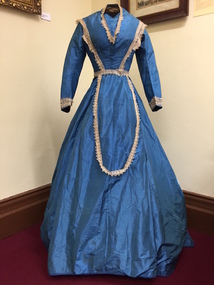
Clothing - Blue Silk Day Dress, 1860-1863
Joseph Butterworth COOMBS (1842-1901), was an accountant who founded a successful mercantile trading company. At the time of his marriage to Caroline Mary MICHEL in 1869, Coombs had already purchased ten acres of Studley Park. The acreage included land on the west of Fenwick Street that extended along lower Stawell Street to the corner of Yarra Street, all of it connected directly to the Yarra environs. A right of way to Studley Park Road was on the title, though Coombs went on to purchase more land, some of which faced Studley Park Road. In addition to owning the Studley Park acreage, Coombs later acquired 1,201 acres of land abutting the Acheron River. While retaining the Kew property he became a Taggerty Councillor and was Shire President for a time. J.B. Coombs died at Acheron Station in 1901 (aged 59 years). A few months after, tenders were called to repair the Kew dwelling, the Fenwick Street property now appearing in records with the name ‘Hope Mansell’. Caroline Coombs remained at Hope Mansell until she died in 1924, survived by three sons and five daughters. Not long after her death, advertisements appeared for the sale of the Studley Park land. The sale seems to have been a mechanism for distribution of the Estate, as the following year the original ten acre holding was transferred to members of the family. The eldest daughter Mabel married William Younger who, with his brother Alexander, developed Younger and Mackie Courts, both south of Studley Park Road. [Research: Kerry Fairbank]In 1961, the granddaughter of Joseph and Caroline Coombs, Mabel Isola (Younger) Grattan, donated ten 19th century dresses and parasols to the Kew Historical Society. The costumes, now known as the 'Coombs Collection', are the earliest recorded items of clothing to enter the Society's collection. Each of the items in the Coombs Collection, of which this item forms a part, is historically, aesthetically and socially significant. As a collection, the costumes includes outstanding examples of morning wear, day dresses, wedding dresses, and clothing accessories, providing evidence of outstanding dressmaker skills in Victoria during the mid to late Victorian period. One-piece, floor length blue silk day dress with a bell skirt that is slightly longer at the back. The dress is joined, centre-front with hooks and eyes. It is probable that the 19th century cream-coloured lace on the bodice and cuffs is a later addition. The lace extends in a long loop at the font of the skirt. The bodice has a high round neck, later modified to a V-shape. The dress must at one stage have been reconfigured or strengthened at the join of the bodice and skirt, as there is evidence of the use of new machine stitching. The dress is fully lined with a stiffened cotton lining fabric. Apart from minor staining, the dress is in excellent condition. The dress is the earliest complete costume in the collection. Measurements - 145.0 cm (centre back) 25.0 cm (waist, flat)Nilcoombs collection, fashion - 1860s, women's clothing, costumes, daywear -
 Kew Historical Society Inc
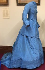
Clothing - Blue Silk Jacket & Skirt, 1868-1872
Joseph Butterworth COOMBS (1842-1901), was an accountant who founded a successful mercantile trading company. At the time of his marriage to Caroline Mary MICHEL in 1869, Coombs had already purchased ten acres of Studley Park. The acreage included land on the west of Fenwick Street that extended along lower Stawell Street to the corner of Yarra Street, all of it connected directly to the Yarra environs. A right of way to Studley Park Road was on the title, though Coombs went on to purchase more land, some of which faced Studley Park Road. In addition to owning the Studley Park acreage, Coombs later acquired 1,201 acres of land abutting the Acheron River. While retaining the Kew property he became a Taggerty Councillor and was Shire President for a time. J.B. Coombs died at Acheron Station in 1901 (aged 59 years). A few months after, tenders were called to repair the Kew dwelling, the Fenwick Street property now appearing in records with the name ‘Hope Mansell’. Caroline Coombs remained at Hope Mansell until she died in 1924, survived by three sons and five daughters. Not long after her death, advertisements appeared for the sale of the Studley Park land. The sale seems to have been a mechanism for distribution of the Estate, as the following year the original ten acre holding was transferred to members of the family. The eldest daughter Mabel married William Younger who, with his brother Alexander, developed Younger and Mackie Courts, both south of Studley Park Road. [Research: Kerry Fairbank]In 1961, the granddaughter of Joseph and Caroline Coombs, Mabel Isola (Younger) Grattan, donated ten 19th century dresses and parasols to the Kew Historical Society. The costumes, now known as the 'Coombs Collection', are the earliest recorded items of clothing to enter the Society's collection. Each of the items in the Coombs Collection, of which this item forms a part, is historically, aesthetically and socially significant. As a collection, the costumes includes outstanding examples of morning wear, day dresses, wedding dresses, and clothing accessories, providing evidence of outstanding dressmaker skills in Victoria during the mid to late Victorian period. Blue silk, floor length day dress comprised of a tightly fitted, long, waisted jacket joined by hooks and eyes at centre front. The bodice features large ornamental buttons from neck to waist, covered in a figured silk fabric of the same colour as the dress. The gown has extensive pin tucking on the sleeves, on the flounce of the skirt, and on the long train. The line of the outfit is emphasised by the flattened front, which is typical of the period. Its cut and lack of adornment emphasises the tailored effect.australian fashion, fashion & design, costumes, dresses, women's clothing, fashion - 1860s, fashion - 1870s -
 Kew Historical Society Inc
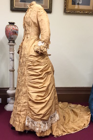
Clothing - Gold Silk Taffeta Wedding Dress with Silk Braid & Tassles, 1875-1880
Joseph Butterworth COOMBS (1842-1901), was an accountant who founded a successful mercantile trading company. At the time of his marriage to Caroline Mary MICHEL in 1869, Coombs had already purchased ten acres of Studley Park. The acreage included land on the west of Fenwick Street that extended along lower Stawell Street to the corner of Yarra Street, all of it connected directly to the Yarra environs. A right of way to Studley Park Road was on the title, though Coombs went on to purchase more land, some of which faced Studley Park Road. In addition to owning the Studley Park acreage, Coombs later acquired 1,201 acres of land abutting the Acheron River. While retaining the Kew property he became a Taggerty Councillor and was Shire President for a time. J.B. Coombs died at Acheron Station in 1901 (aged 59 years). A few months after, tenders were called to repair the Kew dwelling, the Fenwick Street property now appearing in records with the name ‘Hope Mansell’. Caroline Coombs remained at Hope Mansell until she died in 1924, survived by three sons and five daughters. Not long after her death, advertisements appeared for the sale of the Studley Park land. The sale seems to have been a mechanism for distribution of the Estate, as the following year the original ten acre holding was transferred to members of the family. The eldest daughter Mabel married William Younger who, with his brother Alexander, developed Younger and Mackie Courts, both south of Studley Park Road. [Research: Kerry Fairbank]In 1961, the granddaughter of Joseph and Caroline Coombs, Mabel Isola (Younger) Grattan, donated ten 19th century dresses and parasols to the Kew Historical Society. The costumes, now known as the 'Coombs Collection', are the earliest recorded items of clothing to enter the Society's collection. Each of the items in the Coombs Collection, of which this item forms a part, is historically, aesthetically and socially significant. As a collection, the costumes includes outstanding examples of morning wear, day dresses, wedding dresses, and clothing accessories, providing evidence of outstanding dressmaker skills in Victoria during the mid to late Victorian period. Single-piece, floor length, gold silk taffeta evening dress featuring the use of a very long fishtail train to which is attached a silk cord to allow the wearer to hold it above the floor. The dress includes a number of decorative features including the extensive use of box pleats on the sleeves and on the hem of the skirt; contrasting gold and cream braiding and tassles; and the extensive use of ruching on the bodice at the front. Due to the age and fine quality of the silk taffeta used, there is evidence of the degradation of the fabric on one shoulder and a tear in the rear of the skirt. Otherwise the dress is in excellent condition.fashion - 1870s, australian fashion, wedding dresses, costumes, women's clothing, coombs collection -
 The Beechworth Burke Museum Research Collection
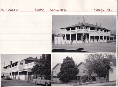
Card (Series) - Index Card, George Tibbits, Camp Street, Beechworth, 1976
George Tibbits, University of Melbourne. Faculty of Architecture, Building and Town & Regional PlanningIndex system that support the research for Beechworth : historical reconstruction / [by] George Tibbits ... [et al]Arranged by street names of BeechworthEach index card includes: street name and number of property, image of property, allotment and section number, property owners and dates of ownership, description of the property according to rate records, property floor plan with dimensions.beechworth, george tibbitsbeechworth, george tibbits -
 Kew Historical Society Inc
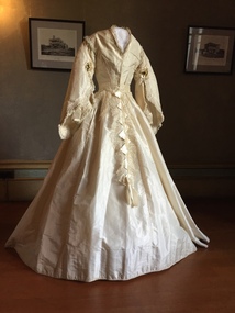
Clothing - White Silk Wedding Dress, c.1869
Joseph Butterworth COOMBS (1842-1901), was an accountant who founded a successful mercantile trading company. At the time of his marriage to Caroline Mary MICHEL in 1869, Coombs had already purchased ten acres of Studley Park. The acreage included land on the west of Fenwick Street that extended along lower Stawell Street to the corner of Yarra Street, all of it connected directly to the Yarra environs. A right of way to Studley Park Road was on the title, though Coombs went on to purchase more land, some of which faced Studley Park Road. In addition to owning the Studley Park acreage, Coombs later acquired 1,201 acres of land abutting the Acheron River. While retaining the Kew property he became a Taggerty Councillor and was Shire President for a time. J.B. Coombs died at Acheron Station in 1901 (aged 59 years). A few months after, tenders were called to repair the Kew dwelling, the Fenwick Street property now appearing in records with the name ‘Hope Mansell’. Caroline Coombs remained at Hope Mansell until she died in 1924, survived by three sons and five daughters. Not long after her death, advertisements appeared for the sale of the Studley Park land. The sale seems to have been a mechanism for distribution of the Estate, as the following year the original ten acre holding was transferred to members of the family. The eldest daughter Mabel married William Younger who, with his brother Alexander, developed Younger and Mackie Courts, both south of Studley Park Road. [Research: Kerry Fairbank]In 1961, the granddaughter of Joseph and Caroline Coombs, Mabel Isola (Younger) Grattan, donated ten 19th century dresses and parasols to the Kew Historical Society. The costumes, now known as the 'Coombs Collection', were the earliest recorded items of clothing to enter the Society's collection. Each of the items in the Coombs Collection, of which this item forms a part, is historically, aesthetically and socially significant. As a collection, the costumes includes outstanding examples of morning wear, day dresses, wedding dresses, and clothing accessories, providing evidence of outstanding dressmaker skills in Victoria during the mid to late Victorian period. Two-piece white silk wedding dress comprised of a short tailored bodice and a bell shaped skirt. The most prominent feature of the bodice is the wide pagoda sleeves, with false undersleeves of muslin. The edge of the sleeves includes small posies of orange blossom. Separate panels of lace, dropping from the waist are the only form of decoration on the skirt. The round high neckline was later converted to v-line in the 19th century.coombs collection, women's clothing, australian fashion, fashion & design collection, costumes, wedding dresses -
 Ringwood and District Historical Society
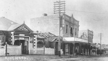
Photograph, Maroondah Highway Central, Ringwood. Ringwood Coffee Palace, 1918
Black and white photograph (2 copies- 1 large, 1 small)Written on rear of backing sheet of large image: "Ringwood Coffee Palace (With Ringwood P.O. on left). Typed on back of small copy: "A.E. Walker arrived in Ringwood in 1910 from Gembrook. Bought land and erected shop. In Oct.1913 he sold out to Capt Miles who had erected Coffee Palace on each side of shop. Then rented shop from Miles. Shop later run by Beilby. -
 Ringwood and District Historical Society
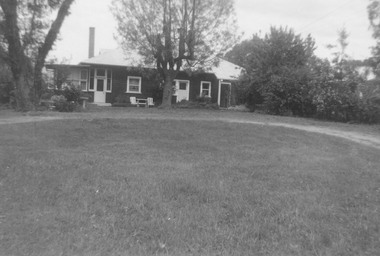
Photograph, Landys home (formerly Patersons). Byways estate area (East Ringwood). 5 Views. (c1968)
SS0261 is the covering letter from Beth Little, dated 31/3/1969, which states: "Please fined enclosed the photographs I took of Landy's 80 yr. old home which was moved just before last Christmas to another site on their estate...it was built by some people by the name of Patterson and originally included the Byways Estate and other land which extended up to about Lillis Crt. The land known as Byways Estate was sold off to a Mr Best by a later owner so far as I can find out.." Written on back of photographs: SS0261a:From about where the feed shed was. SS0261b:Looking up driveway towards the east. Landys home (formerly Patersons). Byways estate area (East Ringwood) SS0261c:Eastern side of house (officially the front). SS0261d:Stable and feed shed now demolished. Wooden tank on right-hand side. SS0261e:Southern side. Well to left of far end of house wall -
 Eltham District Historical Society Inc
Photograph, Henry Dendy c.1875, 1875c
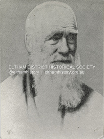
Henry Dendy (1800-1881) is best known as the founder of Brighton. It is not well known that years later he lived far longer at Eltham than he did at Brighton. In 1840 whilst still in England, he bought eight square miles of unspecified land in the Port Phillip district. This entitled him to bring a number of other people to the colony and in 1841 he arrived in Williamstown in the York with his family and 139 others. He took up this land entitlement at what is now Brighton and most of the emigrants settled there. He encountered financial problems and lost his interest in the estate in 1844. He left Brighton in 1847. He successfully not always successfully became a brewer at Geelong, a sheep farmer at Christmas Hills and Upper Moira, a flour miller at Eltham, a sheep farmer again at Werribee and finally a copper miner at Walhalla. Dendy came to Eltham in 1856 after having spent a year in England, he purchased about 5 acres of land in two parts situated each side of Maria Street (Main Road). There was a steam flour mill on that part of the land adjoining the Diamond Creek. He became prominent in local affairs serving for a time on the Eltham District Roads Board including one term as President. Dendy’s wife Sarah died at Eltham in 1860 and also in that year he was appointed Chairman of a committee to establish a Church of England in Eltham. He donated one of his Pitt Street lots for this purpose. St Margaret’s Church was opened on this site in 1861. In 1867 Dendy sold his mill to W F Ford and moved to Werribee and then Walhalla where he remained until his death. He is buried in the Walhalla cemetery. Part of the land on which the Eltham Community Reception Centre stands was the site of Dendy’s house and Mill. Some of the old trees on the site could well have been planted in Dendy’s time. Much of this information was obtained from the book “Henry Dendy and his Emigrants” by L A Schumer.Colour photograph copy of Portrait of Henry Dendy c.1875henry dendy -
 Bendigo Military Museum
Photograph - POSTER PHOTOGRAPHS, 1960
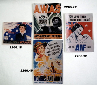
These are copies of original posters reproduced on Photograph paper.Set of photos of women's service posters WW2. .1) WAAAF Recruiting poster coloured photo .2) AWAS recruiting poser photo for AA defence in colour .3) Recruiting poster for AIF showing mother and child. .4) Recruiting poster photo for womens land army .5) Recruiting poster photo women to join red cross. 2 shillings membership in colour. .6) Recruiting poster for women to be a victory job. in colour. .7) Welcome back poster photo displaying woman with red cross badge in colour. posters, photographs, recruiting -
 Bendigo Historical Society Inc.
Document - H.A. & S.R. WILKINSON COLLECTION: CONTRACT OF SALE
Contract of sale dated 26th September, 1957 between Mr. W.B. Nicholls (seller) and Mr. G. Stekelenburg (buyer). Solicitor for vendor: Messrs. Hyett, Willis & Hyett, Bull Street, Bendigo. Solicitor for purchaser: Messrs. Hyett, Willis & Hyett, Bull Street, Bendigo. For lot 34, Alamein Court, Golden Square being lot 34 on plan of subdivision lodged in the office of titles No. A389550 being part of Crown allotment 7 section 31A, being land described in Crown grant volume 8113 folio 731. Price 3,850 pounds.organization, business, h.a. & s.r wilkinson real estate -
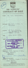 Bendigo Historical Society Inc.
Document - H.A. & S.R. WILKINSON COLLECTION: CONTRACT OF SALE
Contract of sale dated 20th March, 1959 between Mr. M.N. Robertson (seller) and Mr. R.W. & Mrs. B. Stretton (buyer). Solicitor for vendor: Messrs. E.S. Cahill & Son, View Street, Bendigo. Solicitor for purchaser: Messrs. Watson, James & Rogers, Bull Street, Bendigo. For property No. 40 Wade Street, corner McKenzie Street, Golden Square, land being part of Crown allotment 0 section 44B described in certificate of title volume 7100 folio 878, together with blinds and linos as inspected. Price 1,550 pounds.organization, business, h.a. & s.r wilkinson real estate -
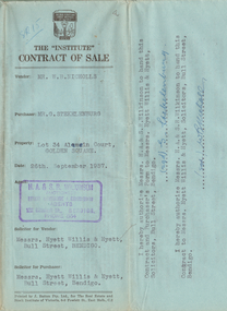
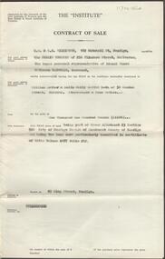
 Bendigo Historical Society Inc.
Document - H.A. & S.R. WILKINSON COLLECTION: CONTRACT OF SALE
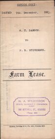
Farm lease dated 9th December, 1933 between W.T. Dawson (lessor) and P.R. Stevenson (lessee) for parcel of land situate in Keck Street, Bendigo approx 2 acres, including dam site with dwellings out-houses and all improvements to have and to hold for a term of 1 year and 4 weeks upon the following conditions: One- the term of tenancy shall be from the ninth of December 1933 to the fifth of January, 1935. Two- that rent for the said term shall be at the clear annual rental of 58 pounds and 10 shillings payable quarterly in advance.organization, business, h.a. & s.r wilkinson real estate -
 Bendigo Historical Society Inc.
Document - H.A. & S.R. WILKINSON COLLECTION: CONTRACT OF SALE
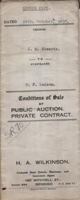
Conditions of sale by private contract dated 26th October, 1937 between J.B. Edwards (seller) and G.F. Sansom (buyer) for land situate ''Hazelbrae'' Corner Russell and Hamlet Streets, Bendigo and occupied by tenant, having a frontage of 82 feet 6 inches to Russell street by a depth of 68 feet 6 inches to Hamlet Street and being part of Crown allotment 22 section 74Cand described in certificate of title volume 3289 folio 657653, together with 5-roomed brick and weatherboard dwelling and all sundry.. Price 465 pounds.organization, business, h.a. & s.r wilkinson real estate -
 Bendigo Historical Society Inc.
Document - H.A. & S.R. WILKINSON COLLECTION: CONTRACT OF SALE
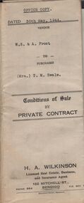
Conditions of sale by private contract dated 30th May, 1944 between W.S. & A. Frost (sellers) and Mrs. T. M. Swale (buyer) for land situate No. 212 Queen Street, Bendigo being Crown allotment 2 section 139C described in certificate of title volume 4557 folio 911246, together with 5-roomed weatherboard dwelling and all sundry. Price 385 pounds. Also attached 6 receipt 2 issued by George Rasmussen, 2 by Langley & Son, 1 by J.S. Barker plus 1 Unknown for various materials.organization, business, h.a. & s.r wilkinson real estate -
 Bendigo Historical Society Inc.
Document - H.A. & S.R. WILKINSON COLLECTION: CONDITION OF SALE
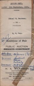
Conditions of sale by public auction issued by H.A. Wilkinson and dated 6th September 1950 between miss H. Barrass (seller) and H. W. Ray (buyer) for land situate No. 139 Queen Street Bendigo at present occupied by Mr. L.J. Lobb a tenant, being lot 1 on plan of subdivision made by Mr. A.E. Pritchard dated 13th August 1950 and being part of Crown allotment 10 section 90C, together with 5-roomed weatherboard dwelling and all sundry. Subject to existing weekly tenancy. Price 870 pounds.organization, business, h.a. & s.r wilkinson real estate -
 Bendigo Historical Society Inc.
Document - H.A. & S.R. WILKINSON COLLECTION: CONDITION OF SALE
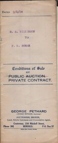
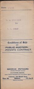
Conditions of sale by private contract issued by George Pethard Auctioneer and dated 9th June, 1924 between H. A. Wilkinson as seller and F. R. Rosan as buyer. Land situate at 121 Mundy Street Bendigo at present occupied by Mrs. Hodge as tenant being Crown allotment 10 of section 8C Parish of Sandhurst city and county of Bendigo described in certificate of title volume 2732 folio 546267 and having a frontage of 125 links by a depth of 200 links, together with 6-roomed brick house and all sundry. Price 575 pounds.organization, business, h.a. & s.r wilkinson real estate -
 Bendigo Historical Society Inc.
Document - H.A. & S.R. WILKINSON COLLECTION: CONDITION OF SALE
Conditions of sale by private contract issued by George Pethard Auctioneer and dated 9th June, 1924 between H. A. Wilkinson as seller and F. R. Rosan as buyer. Land situate at 121 Mundy Street Bendigo at present occupied by Mrs. Hodge as tenant being Crown allotment 10 of section 8C Parish of Sandhurst city and county of Bendigo described in certificate of title volume 2732 folio 546267 and having a frontage of 125 links by a depth of 200 links, together with 6-roomed brick house and all sundry. Price 575 pounds.organization, business, h.a. & s.r wilkinson real estate -
 Bendigo Historical Society Inc.
Newspaper - JENNY FOLEY COLLECTION: PALL MALL
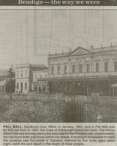
Bendigo Advertiser ''The way we were'' from 2000. Pall Mall: Sandhurst circa 1860s. In January, 1865, land in Pall Mall sold for 90 pounds per foot. In 1867, the Duke of Edinburgh visited the town. The Prince Albert Hall was erected next to the town hall for the Prince's visit. Unfortunately, the hall burnt down just hours before his arrival. A torchlight procession to mark the occasion saw the model of 'Galatea', manned by four boys, aged about eight, catch fire and result in the death of three people. The clip is in a folder.newspaper, bendigo advertiser, the way we were -
 Bendigo Historical Society Inc.
Document - NORMAN OLIVER COLLECTION: SPEECH NOTES 22 AUGUST 1951
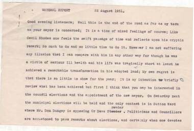
The Norman Oliver collection. Norman Oliver was three times Mayor of Bendigo - 1950-51, 1964-65, 1970-71. Sixteen pages of typed notes headed Mayoral Report 22 August 1951. Corrections in blue ink. In the format he used for his talks on 3BO 'The Mayor Speaks'. The last report for his first Mayoral term. Topics include : the Year's work - land reclamation, the loan for earth moving plant, garbage disposal, sports grounds, drainage, Sewerage Authority, the saleyards, the Aerodrome, Housing, and the Bendigo Creek and town planning.bendigo, council, speech notes, norman joseph oliver , councillor norman oliver. mayor of bendigo. 3bo 'the mayor speaks'. -
 Bendigo Historical Society Inc.
Document - H. A. & S. R. WILKINSON COLLECTION: CONTRACT OF SALE
Contract of sale dated 9th December, 1963 between the public trustee of 256 Flinders Street, Melbourne as representative of L. M. M. McDonald - Deceased (vendor) and Mr. W. A. & Mrs. L. E. Santon (purchaser). Solicitor for vendor: The Public Trustee, 256 Flinders Street, Melbourne. Solicitor for purchaser: Mr. J. F. Whelan, Mitchell Street, Bendigo. Property: 49 King Street, Bendigo, land being part of Crown allotment 23 section 52C described in certificate of title volume 4187 folio 212. Price 1,100 pounds.organization, business, h.a. & s.r wilkinson real estate -
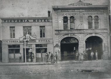 Bendigo Historical Society Inc.
Photograph - VICTORIA HOTEL AND JONES BIRD & CO, BENDIGO, 1861
Black and white copy: two buildings adjoining with assorted males grouped on footpath and doorways. Victoria Hotel and Jones Bird & Co., Pall Mall, Bendigo between Mitchell St. & Williamson St., Victoria Lane beside hotel. Victorian coat of arms on doorway. ( James Lerk 22.9.2000 ). On window 'Edward Francis/Ward/Attorney at Law/& solicitor' S. Jones and Sons, L. McPherson & Co. ' Auctioneers, Valuators/Land Estate Commission Agents' ' Livery Bait and Commission Yards ' ' Horses Carriages & Dog Carts…/ Horses Broken, Double and single harness '.Batchelderbuildings, commercial -
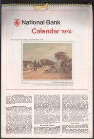 Bendigo Historical Society Inc.
Document - NATIONAL BANK CALENDAR 1974
National Bank calendar 1974 featuring thirteen coloured views of provincial towns in early Australia. Part two in series. 1. Richmond looking West. 2. New Norfolk [Tasmania] 3. Mount Barker [SA] 4. West Maitland [NSW] 5. Gympie in 1887 [Qld] 6. Sandhurst [Vic] 7. Kiama [NSW] 8. View of Fremantle [WA], 1832. 9. Goulburn [NSW] 10. Yorkton, Port Dalrymple, Van Diemen's Land 1808. 11. Daylesford [Victoria] 12. Stanthorpe, 1888 [QLD]australia, history, colonies, establishing