Showing 11129 items
matching planning
-
 Robin Boyd Foundation
Document - Receipt, Foster Parents Plan of Australia, Foster Parents, April and May 1971
Two receipts paid by Robin Boyd to Foster Parents Plan of Australia for $14.50 in April and May 1971.Green slips, two pages each. -
 Clayton RSL Sub Branch
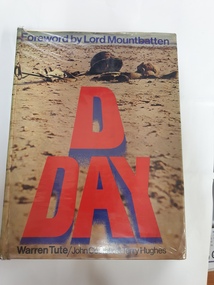
hard cover non-fiction book, Nautic Presentations, D-Day: Dawn to midnight June 6, 1944, 1974
Information contained in the book came from reports, secret planning papers drawing from memoirs and diaries.Foreward by Lord Mountbattenhard cover non-fiction booksticker on the inside jacket: P.Cooper (personal details noted) Sticker The Library United Service Institution of Victoria -
 Stawell Historical Society Inc
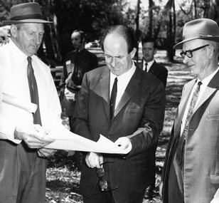
Photograph, Hall’s Gap Tourist Promotion Officer Mr Ian R. McCann in the centre studing Pool Plans 1970
Group at Pool Site with Plans. Hall’s Gap Tourist Promotion Officer I.R. McCann at centre 1970stawell -
 University of Melbourne, Burnley Campus Archives
Plan, Rainforest Garden Development VCAH Burnley, 1990-1992
Some of these plans were held in P. Tulk's office, used by Honours Student, Linda Hipwell in 1999. (1a) Rough sketch on tracing paper. (1) Rainforest Project drawn by G. Olive, rough sketch pen and pencil on paper. (2) 1 tracing paper and 2 paper copies, Rainforest Garden Development Plant Schedule Key by type of plant. (3) Blueprint of Rainforest Garden Development, plant names beside plants, note to P. Tulk from J. Kellow. (4) Native Garden Burnley VCAH Hort Eng. II. Surveying by Gail, John, Rebecca, Sean, Tim (Students). g. olive, phil tulk, linda hipwell, vcah, students, rainforest, gardens -
 City of Kingston
Pamphlet - Colour, Ozone Hill Estate, Cheltenham, 1923
Sales plan for land in the suburb of Cheltenham, along both sides of Victori Avenue, off Weatherall Road.The developing urban area of Cheltenham within the City of Kingston. This land sale pamphlet illustrates the subdivision of land within the municipality and the changing demographic of the district as new houses are constructed.Colour pamphlet advertising for sale the Ozone Hill Estate, Cheltenham. Incorporates a map of the estate on either side of Victor Avenue, off Weatherall Road. Handwritten in blue ink on the subdivision map: 'Sold' is written on subdivisions 1-4, 8, 11, 13, 16-26, 28, 29, 33, 39-41 Handwritten in blue ink on the subdivision map: 'House being erected' is written on subdivisions 22 and 33. Handwrittten in grey pencil adjacent to subdivisions 21 and 22: Tennis / Courts / being / constructed / here Handwritten in grey pencil at bottom of page: Revised to 30/1/24 Handwritten in grey pencil on subdivision map: assumed land sale price is recorded on subdivisions 5-9, 9-10, 12, 14-15, 27, 30-32, 34-38. land sales, cheltenham, estate -
 City of Kingston
Pamphlet - Black and white, J. F. Brady, The Hill Estate, Highett, c. 1905
Sales plan for land in the suburb of Highett, bounded by Sandford Street, Turner Street and Point Nepean RoadThe developing urban area of Highett within the City of Kingston. This land sale pamphlet illustrates the subdivision of land within the municipality and the changing demographic of the district as new houses are constructed close to infrastructure.Black and white pamphlet advertising for sale the Hill Estate, Highett. Incorporates a map of the estate bordered by Sandford Street, Turner Street and Point Nepean Road.Handwritten in grey pencil on reverse: The Hillland sales, highett, estate -
Port Melbourne Historical & Preservation Society
Document - Research report, Heritage study of "Clareville" and McCormack Gallery", Robyn Clinch, Heritage Study of "Clareville"and the "McCormack Gallery" Port Melbourne, Jan 2008
Submitted as part of the requirements for the subject "Heritage Planning"at RMIT University for the degree of Master of Social Science Environment.wHeritage Study of "Clareville"and the "McCormack Gallery" Port Melbourne - A4 bound with red plastic comb. 62 pages with red back. Contains comparative studies from Port and South Melbourne, photos and mapsbuilt environment - civic, built environment - domestic, port melbourne temperance hall, town planning, heritage, robyn clinch, clareville, mccormack gallery, frederick williams, william hutcheson gresham, jane dixon, maxwell ingles, john gall, james john bartlett, edward w m suffolk, ann mcgrath suffolk, edward dicker mathews, elizabeth payne beck mathews, thomas mccormack, mathew mccormack, catherine larkin mccormack, maryann farnan mccormack, alexander james doig, alice bevan doig, stephen spadier, harriet jane blackell spadier, cricketers arms hotel -
 Glenelg Shire Council Cultural Collection
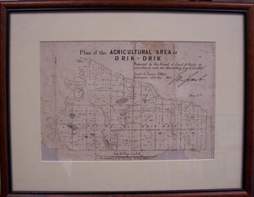
Map - Map of Drik-Drik, 1865
Displayed at History House.Print of map pasted onto board, mounted and framed under glass. Buff-coloured mount. Mahogany stained moulded wood frame, black inner frame.Front: Plan of the Agricultural Area of Drik-Drik L.2556/Prepared by the Board of Lands and Works in accordance with the "Amending Land Act 1865". Lands and Survey Office, Melbourne 11th May 1865. (printed, upper centre). Back: Duncan Hedditchmap, drik drik, plan, geography, cartography -
 Ringwood and District Historical Society
Book, Community Guide 2012 Maroondah City Council, Ringwood Victoria
Community information book issued by City of Maroondah for 2012 covering the facilities and activities of the Ringwood Council and other local organisations and associations. Includes contact details for Council services, community organisations and emergency services. Supplement - Maroondah In Focus newsletter Sept to Nov 2012 includes features on Ringwood Regional Aquatic and Leisure Centre construction, wiping out graffiti, Council's Youth Plan, Costco comes to town, Eastland transformation early works, Library Learning and Cultural Centre funding, Sherbrook Park plans, Pedestrian safety, -
 Bendigo Historical Society Inc.
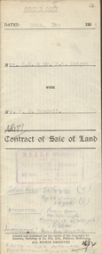
Document - H.A & S.R. WILKINSON COLLECTION: CONTRACT OF SALE
Contract of sale of land dated 29th May, 1954 between Mrs. E.M. & Mr. H.A. Knight (sellers) and Mr. W.H. Randall (buyer) for land being lot 2 on plan of subdivision No. 19227 being parts of lots 27 and 28 on plan of subdivision No. 4134 being part of Crown allotment 97 and being the balance of the land comprised in certificate of titles volume 6441 folios 021 and 022 and situate Albion Street, Bendigo. Together with weatherboard dwelling and all sundry. Price 2,200 pounds.organization, business, h.a. & s.r wilkinson real estate -
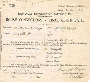 Bendigo Historical Society Inc.
Document - BENDIGO SEWERAGE AUTHORITY : HOUSE CONNECTIONS - FINAL CERTIFICATE : 6 APRIL 1925, 06/04/1925
Bendigo Sewerage Authority. House Connections - Final Certificate. Dated 6/4/1925. A small document pertaining to 60 Wills St. Owner: Mr W. J. Parry. No. 729, Drainage plan No. 1220, Detail Plan No. 39. Description: weatherboard cottage. Four people have signed the form: V. Smyth (certified plumber), D. Smyth (licensed drainer), S. J. Beggs (officer supervising house connections), and Eric A. Owen (acting Engineer in Chief). The form is stamped 14 Jul 1925.bendigo, utilities, bendigo sewerage authority. owen, eric a. smyth v. smyth d. beggs, s. j. 60 wills st, bendigo. -
Bendigo Historical Society Inc.
Document - BUSH COLLECTION: LAND TRANSACTION LEDGER, 1880 - 1920
Handwritten ledger (alphabetized) of land transactions of Albert Bush, with numerous loose handwritten notes throughout. Plans are at the back (inside cover) of the book. One plan attached on inside front cover. Pages are arranged with information in columns - 1. Name, 2. Nature and particulars of security, 3. Situation and extent, 4. Amount and when payable, 5. Interest (paid and now payable), 6. Remarks. This ledger would be most informative with further research and indexing. 23/01/2020 Item missing AVperson, individual, bush collection - personal -
Whitehorse Historical Society Inc.
Article, Rezoning plan riles retailers, 1992
Despite widespread disapproval by traders and residents, Nunawading Council still plans put its draft structure plan for Vermont South Activity Centre on public display.Despite widespread disapproval by traders and residents, Nunawading Council still plans put its draft structure plan for Vermont South Activity Centre on public display. Council owned land on Burwood Highway is earmarked for rezoning to restricted business zone. The draft has designated the area for a mix of office and retail development. it is not intended to duplicate retail services which already exist. Manager of Vermont South Shopping Centre Patricia Wilson says the traders object to any amount of extra retail development.Despite widespread disapproval by traders and residents, Nunawading Council still plans put its draft structure plan for Vermont South Activity Centre on public display.shops, city of nunawading, wilson, patricia, vermont south shopping centre, burwood highway, vermont south, nos 473-493 -
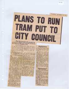 Ballarat Tramway Museum
Newspaper, The Courier Ballarat, "Plan to run tram put to City Council", 12/10/1971 12:00:00 AM
Newspaper clipping from The Courier, 12/10/1971, titled "Plan to run tram put to City Council" about the City of Ballaarat considering plans from the BTPS for the construction of a depot in the South Gardens Reserve, consideration of a grant of $750 for the sheltering of tram No. 14. Quotes President Hal Cain about the proposals of the Society, and elements of the submission to council requesting assistance to run the track from View Point to Carlton St. Sir Arthur Nicholson said "super optimists", refers to the editorial.. Cutting in two parts.btps, depot, city of ballarat, preservation -
University of Melbourne, Burnley Campus Archives
Plan, School of Primary Agriculture & Horticulture - Burnley, c. 1925-1926
Copy of plan photographed at the Public Records Office Victoria. Central Administration Correspondence Files 1912-1939 ITEM. VPRS 10163/P0003/2. Accomodation Burnley School Part 1. Traced from M.M.B.W. Plan No. 42. Scale 160 ft=1 in. Level Datum L.M.N. Hobson's Bay. Traced by C.E.B.W. 16.02.1926. Additional matter in red and green inserted by F.E.T.C. 09.02.1926. Note by J.J. Rae (Principal). Lists W.C.s (toilets). Shows 1891 Flood Line. Possibly dates from 1925.prov, school of primary agriculture and horticulture, burnely, j.j. rae -
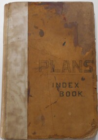 Bendigo Historical Society Inc.
Document - LANDS OFFICE, - INDEX TO CROWN LANDS SURVEYED AND SOLD IN THE DISTRICT OF SANDHURST
Document: Buff hard cover book, with fawn coloured binding on spine (later addition to mend spine?) On front cover drawn in black pen ' PLANS' and 'Index Book' On spine written in black ink ' plans index book'. Contains index of parishes in front of journal with 470 pages indexed to parishes. Double page entries: LH side page: town, suburban or country lands, total lands surveyed. Date of survey. RH page: allotment, section, particulars, no. page. Entries are not dated.Lands Officeland sales, lands office, land surveyed , land sold, bendigo, sandhurst -
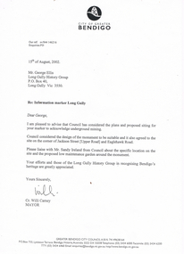 Bendigo Historical Society Inc.
Document - LONG GULLY HISTORY GROUP COLLECTION: LETTERS
BHS CollectionTwo letters from the City of Greater Bendigo to Mr. George Ellis. The first dated 15/8/2002 mentions the Council has considered plans and proposed site for a marker. It is mentioned to liaise with Mr. Sandy Ireland about the specific location. Signed Cr Willi Carney. The second letter, dated 6/11/2002 is an application for a building approval for a poppet Legs Monument. There are also two plans, Sheet 1 is Framing Sizes (Proposed) and Sheet 2 Base Details. Both sheets are dated July 02.bendigo, history, long gully history group, the long gully history group - letters, city of greater bendigo, george ellis, long gully history group, marker, sandy ireland, maurie betts, david turner -
 Bendigo Historical Society Inc.
Document - MARKS COLLECTION: MINING LEASE BLOCKS 1873
Plan mining lease blocks 1873, timber hanger on top two brass rings, securing tape, round timber holder on bottom, scroll. On top Schedule of Mining Lease Blocks shown on the plan of the Sandhurst Gold Field, Published May 1873' Names of mining Companies listed with identifying number and area of mine site. E.g. '447 Johnson's Reef Gold Mines 7a, 2r, 8 p (acres, roods, perches). Number linked to the mine site shown on Sandhurst Gold Field map.bendigo, mining, mining lease blocks 1873 -
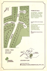 Ringwood and District Historical Society
Flyer, Land Sale Advertisement - Banool Gardens Subdivision, Ringwood, Vic. c.1985
Double-sided advertisement for Banool Gardens subdivision with site plan, location plan, terms of sale, and summary of homesite features and local services & facilities. Subdivision includes Wonga Road, Hamilton Drive, Tinworth Place, Andrea Parade and Benjamin Court, Ringwood North. Managing agent - Ollson Real Estate Pty. Ltd., North Croydon Shopping Plaza, Maroondah Highway. Croydon, Vic. 3136. Telephone 726 9988 After Hours 876 4190. Project by Darnley Developments (Vic.) Pty. Ltd. Accompanying handwritten notation by Richard Carter R.E.S.I. - "Part of original Banool property (Mahon, sold to Stallman, sold to McMahon, sold to Len Macley etc etc). Hamilton Drive named after Lynn Hamilton McMahon, Tinworth Place after his son-in-law, David Tinworth". -
University of Melbourne, Burnley Campus Archives
Plan, New School of Primary Agriculture & Horticulture Burnley Gardens, 1945
Photocopy of Plan of the Administration Building by the Chief Architect dated 26.9.45. Scale 1/8 inch - 1 foot. Photocopy reduced in size from original. (1) Ground Floor and First Floor Plans. (2) West Elevation, Longitudinal Section 'B-B' and East Front Elevation. (3) Flat Roof, Library and Herbarium. (4) Common Room and Assembly Hall. Originally in the Burnley Archives. Property and Service now have the original and gave the reduced size photocopy to the Archives. Hard to read now.burnley gardens, school of primary agriculture and horticulture -
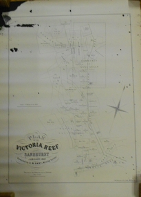 Bendigo Historical Society Inc.
Document - MARKS COLLECTION: MAP OF VICTORIA REEF MINING CLAIMS
Copy of map. On bottom LH side: Plan of the Victoria Reef Sandhurst January 1867, Compiled by G.W. Hart, Mining Surveyor. Published by John N. Macartney, Argus Agent, Sandhurst. Price 4/- each. On bottom Rh side J.W. Pearson & Co. Lith. Melbourne Plan shows mining claims and names of holders, scale (4 chains to one inch) Loddon Road, Mount Korong Road, Ironbark Gully, township of Long Gully, Quartz Miners' Arms and Gold Mines Hotel on Loddon Road.bendigo, mining, victoria reef plan -
University of Melbourne, Burnley Campus Archives
Plan, Ellis Stones Rockery, 1962-1999
(1) Note by Phil Tulk, Gardens Manager, c. 1999 re Restoration of the Ellis Stones Rockery originally planted in 1962. (2) 3 photocopies of Ellis Stones' original plant list. (3) 2 photocopies of a hand drawn planting plan, 1 has names of plants written in pencil, the other just has numbers with no key attached. (4) Handwritten list with descriptions of plants. Also see B15.0527 (Documents B0x 73 for more information re planting plan. Also numerous photographs.gardens manager, phil tulk, rockery, ellis stones -
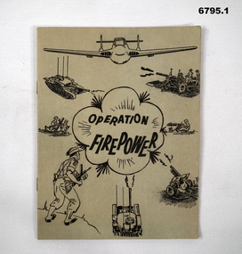 Bendigo Military Museum
Manual - TRAINING MANUALS VARIOUS, 1937, 1959
1. An instruction manual outlining the structure of a military exercise to practice Battle activity at a Brigade level. 2. An instruction manual outlining the proper way to read a map and the logic of it's structure. 3. Illustrative guide on what leaders should expect in relation to their soldiers. Items in the collection re Col J Swatton, refer Cat No 6719.2P for his service details.1. Green cover, 16 page booklet titled " Operation Firepower" . Dated March 1959, which planned an army exercise at Brigade Level. Outlined aim, Tactical setting, maps and plans. 2. Loose stapled 28 page manual on reading maps. Yellow paper with three folder holes punched in left size. Contains instructions and pictures and examples. 3. Brown covered manual, yellow faded pages, 60 pages inside with pictorial content displaying the do's and don't's of the behaviour of a good soldier.1. Maps have some notations, images of vehicles/weapons on front. 2. Titled " Map Reading - Supplement A.T.M. (AUST) No 12". Written on top " Colonel J.W. Swatton". 3. Titled "Right or Wrong": Element of Training and Leadership illustrated 1937". Stamp on back saying "on loan" but now donated.passchendaele barracks trust, training manuals -
 Bendigo Historical Society Inc.
Map - GREAT EXTENDED HUSTLER'S MINE - PLAN OF THE GREAT EXTENDED HUSTLER'S MINE
Plan of the Great Extended Hustler's Mine on the Hustler's Line of Reefs, Bendigo. Bulletin No 33, Plate No X. Lease No 7382. Plan has map of streets. Mine was located in the block bounded by Langston and Anderson Streets and was between the Hustler's Anticline at Surface and the Lightning Hill Anticline at Surface. Latham & Watson's Shaft is also mentioned. Levels are numbered and a table shows the Levels and their Depths. Geological Survey of Victoria. Signed by H A Whitelaw, Underground Survey Office, Bendigo, September 1913. This item has not been scanned or photographed.mining, parish map, great extended hustler's mine, hustler's line of reefs, mining lease no 7382, geological survey of victoria, underground survey office bendigo, h a whitelaw, latham & watson's shaft -
 Eltham District Historical Society Inc
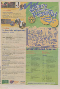
Newspaper clipping, Program; Rotary Eltham Town Festival 19-20 November 2005, Diamond Valley Leader, 16 November 2005, p8, 2006
News articles on reverse (p7) include stories on Councillors refusing plans on a three-storey development in Ramptons RoadNewsprintdevelopment application, eltham festival, eltham north, nillumbik shire council, ramptons road, program -
 Eltham District Historical Society Inc
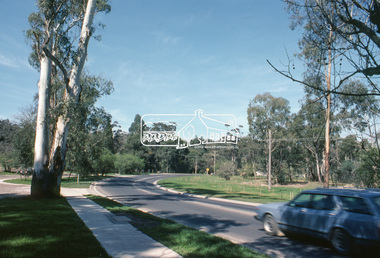
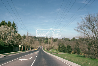
Slide, Main Road, Eltham South, 15 Sep. 1982
One of a series of images of roads and infrastructure taken by Eltham Shire Council Planning and Engineering officers, September 1982.35 mm colour positive transparency (1 of 4) Mount - Kodak Kodachrome CardProcessed 15 Sep1980eltham, eltham south, infrastructure, main road, roads -
 Eltham District Historical Society Inc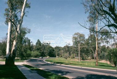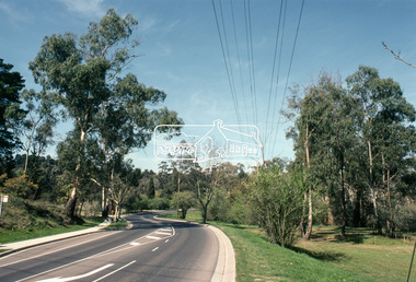
Slide, Main Road, Eltham South, 15 Sep. 1982
One of a series of images of roads and infrastructure taken by Eltham Shire Council Planning and Engineering officers, September 1982.35 mm colour positive transparency (1 of 4) Mount - Kodak Kodachrome CardProcessed 15 Sep1980eltham, eltham south, infrastructure, main road, roads, avenue of honour -
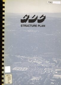 Greensborough Historical Society
Book - Planning Document, TTM Consulting Pty Ltd, Greensborough District Centre: Structure plan, 1989, 1989_07
A summary of investigations into impacts of the Greensborough District Centre in 1989, with plans for the development of the East side of Main Street Greensborough.91 pages text and black and white line drawings. One colour fold out map. Black plastic binding and clear plastic cover. greensborough district centre, main street greensborough, greensborough plaza