Showing 24370 items
matching matthew-creek
-
 Federation University Historical Collection
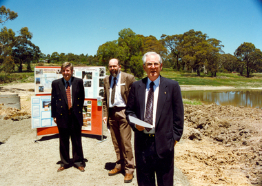
Photograph - Photograph - Colour, Canadian Wetlands at the Ballarat Technology Centre, c2000
During the construction of the Ballarat Technology Park a wetland area was protected. Associated with Canadian Creek it is known as the Canadian Wetland/Two photographs showing the Canadian Wetlands at the Ballarat Technology Park. .1) Left to Right, Rob McLellan (Victorian Minister), Martin Westbrooke (Science/Engineering faculty); David James (University of Ballarat Vice Chancellor) .2) Left to Right, Rob McLellan (Victorian Minister), David James (University of Ballarat Vice Chancellor)david james, mclellan, westbrooke, martin westbrooke, ron mclellan, canadian wetlands, ballarat technology centre -
 Tatura Irrigation & Wartime Camps Museum
Book, The Pennyweight Kids, 1988
Written to try to discover why more than 200 children died at Forest Creek, Victoria. Stories of their families.Yellow cover, sketch of scales 1852-1857. Gold mining scene and grieving mother. On back cover sketch of excavation of old burial site. London 1852. Gentleman's Magazine.forest creek victoria, deaths at forest creek victoria -
 Clunes Museum
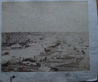
Photograph, NETTLETON. PHOTO. MELBOURNE, FRASER STREET, CLUNES, CIRCA 1866-67
PHOTOGRAPH OF FRASER STREET, FROM CAMP PARADE ABOUT 1866-67. NOTE STATE OF CREEK AND ABSENCE OF BRIDGES.PHOTOGRAPH OF FRASER STREET, CLUNES. TAKEN FROM CAMP PARADE .1 SEPIA PHOTOGRAPH MOUNTED ON CARDBOARD, .2 BLACK AND WHITE PHOTO PRINT .3 BLACK AND WHITE PHOTO PRINT MOUNTED ON CARDBOARD, TITLED CLUNES FROM CAMP PARADE - ABOUT 1865 .4 SEPIA PHOTOGRAPH MOUNTED ON BOARD WITH NOTES OF PLACES OF INTEREST AROUND PHOTO. TITLED FRASER STREET CLUNES. .5 BLACK ANBD WHITE PHOTO PRINT .6 SMALL PHOTO PRINT .7 SMALL PHOTO PRINT WITH DESCRIPTION ON BACK .8 SMALL PHOTO PRINT .9 SEPIA PHOTO PRINT .10 SEPIA PHOTO PRINTFRASER ST. CLUNESlocal history, photography, photographs, clunes township, early fraser street -
 Ballarat Heritage Services
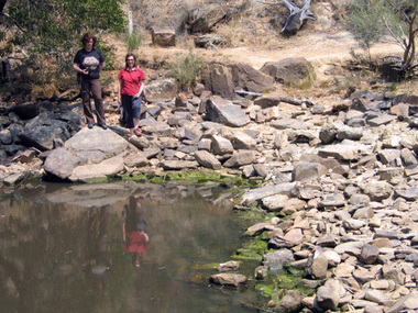
digital photographs, Lisa Gervasoni, Blowhole Pool, Hepburn Regional Park, c2006
The Blowhole is an artifical diversion tunnel in the Jim Crow Creek made by Chinese miners seeking gold around the 1870s. Ann Gervasoni and Clare Gervasoni stand on the edge of the pool associated with The Blowhole. hepburn, hepburn regional park, blowhole, mining, heritage, chinese -
 Ballarat Heritage Services
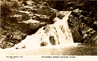
Photograph - Postcard, Rose, The Blowhole, Hepburn, Victoria
The Blowhole resulted after Chinese miners diverted Jim Crow Creek so they could search for gold in the riverbed. Black and white postcard of the Blowhole in Hepburn Regional Park.the blowhole, hepburn, chinese, jim crow creek -
Hume City Civic Collection
Photograph, Goonawarra Winery
In the 1980s John and Elizabeth Barnier were the owners of the Goonawarra Winery, located by Jacksons Creek and along Sunbury Road.Goonawarra Winery is one of the first vineyards t6o be established in the district.A mounted coloured photograph of Goonawarra Winery taken in 1986.goonawarra winery, jacksons creek, sunbury, wine, barnier john, elizabeth barnier, grapes -
 Tarnagulla History Archive
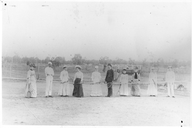
Photograph: Tarnagulla Tennis Team (1894), 1894
This image depicts the old Tarnagulla tennis court which was on Sandy Creek Lane, Tarnagulla. Donald Clark Collection. A monochrome photograph of people on a tennis court holding racquets. Captioned as Tarnagulla Tennis Team, 1894. Copy photograph. -
 Mont De Lancey
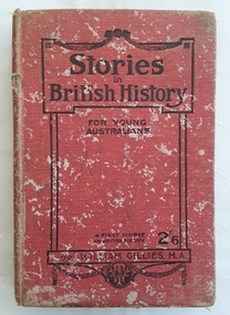
Book, William Gillies, M.A, Stories in British History for Young Australians, 1920
A simple study in British History for secondary school students with a fold out map of the British Empire at the time - published in 1920. There is a list of the dynasties and kings and queens and a table of Periods in British History which can be referred to.A badly damaged red cloth covered hardcover book with the title: Stories in British History for Young Australians printed in black lettering on the front cover with the publisher, a round publisher symbol and 2/6 at the bottom. The title is printed on the spine. This is a First Course in British History by William Gillies, M.A. Inside, opposite the title page, is a lined sketch of Oliver Cromwell. Black white illustrations, maps and photographs are included. At the back is an Index as well as three additional recommended titles of other history books. Considerable markings, lists and a love poem is scribbled at the back. It is quite damaged and worn through use. Pp.315.non-fictionA simple study in British History for secondary school students with a fold out map of the British Empire at the time - published in 1920. There is a list of the dynasties and kings and queens and a table of Periods in British History which can be referred to.great britain - history, history, textbooks -
Bendigo Historical Society Inc.
Map - KAMAROOKA : COUNTY OF BENDIGO, 29-8-21
Map. Kamarooka, County of Bendigo, Milloo, Warragamba, Minto, Whirrakee, Tandarra, Piccaninny Creek, Dingee. By authority A.J. Mullett, Govt. Printer. Photo-Lithographed at the Department of Lands and Survey, Melbourne by W.J. Butson 29-8-21. Price 1/-. (number 63 in map cupboard 1)A.J. Mullett, Govt.Printermap, bendigo, kamarooka -
 Bendigo Historical Society Inc.
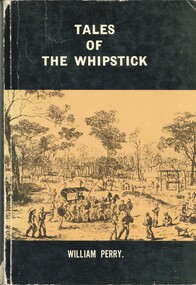
Book - TALES OF THE WHIPSTICK, 1975
'Tales of the Whipstick'. A history of mining and other activities in the Whipstick forest. This book contains stories from surrounding areas including Neilborough, Sebastian, Raywood, and the Myers Creek Gold Rushes, Victoria Australia. 250 pages. B&W photographs. With Index compiled by Ralph Birrell. Signed by the Author.William Perrybook, bendigo, whipstick -
Bendigo Historical Society Inc.
Map - BRIDGEWATER : COUNTY OF BENDIGO, 6-10-27
Map. Bridgewater, County of Bendigo, Inglewood, Salisbury, Derby, Leichardt, Yarraberb, Yarrayne, Bullock Creek, Loddon River, Sandhurst and Inglewood Railway. Photo-Lithographed at the Department of Lands and Survey Melbourne by W.J. Butson, 6-10-27. Price 1/-. (number 53 in map cupboard 1)W.J. Butsonmap, bendigo, bridgewater -
Bendigo Historical Society Inc.
Map - BAGSHOT, COUNTY 0F BENDIGO, 24-5-21
Map, Bagshot, County of Bendigo,Whirrakee, Egerton, Goornong, Ellesmere, Wellsford, Huntly, Reedy Creek, Sandy Creek.Photo-Lithographed at the Dept. of Lands and Survey, Melbourne by W.J.Butson, 24-5-21. Price 1/-.. By authority A.J.Mullett, Govt. Printer,Melbourne. (number 49 in map cupboard 1)A.J.Mullett, Government Printer, Melbourne.map, bendigo, bagshot -
 Bendigo Historical Society Inc.
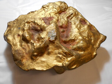
Memorabilia - GOLD NUGGET COLLECTION: 'THE SCHLEMM'
A plaster model of the Sclemm nugget found on 11.7.1872 at the Shoots Gully between Dunolly and James Creek, three feet below the surface. Associated with quartz and ironstone. Weight 538 ozs. Estimated yield 478 ozs. Finder Henry Davey. Value 2016 $849,760. (See additional research)mining, models, plaster model of victorian gold nugget -
Clunes Museum
Map, 1962
.1 &.2 MAP OF BALLARAT SHIRE GROUP RURAL FIRE BRIGADES FIRE CONTROL MAP. COMPILED BY C. H. FENTON. (2 COPIES) DETAILING SEALED ROADS, STATE FORESTS, PINE PLANTATIONS, FOREST AREAS, RAILWAYS, BOUNDARIES, TOWNSHIP AREAS CEMETERIES, CREEKS, SWAMPS AND HOUSES.local history, document, maps, fire brigade -
Whitehorse Historical Society Inc.
Map, Melbourne Metropolitan Area Base Map series. Sheet 214, c1960
Map showing northern section of the City of Nunawading together with parts of Shire of Doncaster and Templestowe.Map showing northern section of the City of Nunawading together with parts of Shire of Doncaster and Templestowe. Shows roads, creeks, block numbers and contours at 5 feet vertical increments. Note on map: 'prepared ... from State Aerial Survey, January 1957 and Cadastral Survey information February 1959'.Map showing northern section of the City of Nunawading together with parts of Shire of Doncaster and Templestowe. maps, city of nunawading, shire of doncaster and templestowe -
 Whitehorse Historical Society Inc.
Photograph, Grace Begg
Black and white photo of Grace Begg, born 15/9/1857, married Russell Scott Thomas 17/8/1890 at Heathcote, Victoria. Lived at Albert Park. Grandmother of Russell Alexander, Creek Road, Mitcham. (Russell's Menswear, Whitehorse Road, Mitcham). Cross Ref: NA2693.begg, grace, alexander, russell, stan russell menswear -
 Lakes Entrance Regional Historical Society (operating as Lakes Entrance History Centre & Museum)
Photograph, Fish Marie, 1997
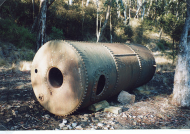
Date made 18 January 1997Colour photograph of a boiler which provided steam power to drive a winch at North Arm. Rock was transported from Mississippi Creek quarry along a tramline to North Arm where rock was transferred by steam powered winch to a barge which carried rock to the entrance. Lakes Entrance Victoriavegetation, boats and boating, topography -
 Lakes Entrance Regional Historical Society (operating as Lakes Entrance History Centre & Museum)
Photograph, 1930
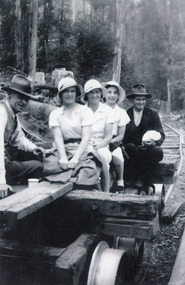
During summer, after the last load of rock for the week had been delivered to the landing, the trolley would be used as transport for a picnic in the bush nearby.Black and white photograph of two men and three young women in summer dresses and hats sitting on a trolley on the Mississippi Creek tramline. One man in tidy suit, the other appears to be in working clothes. Dense bush in background, tea cup on cross beam of trolley. East Gippsland Victoriawaterways, jetties -
 South Gippsland Shire Council
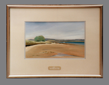
Painting, Framed, Mahers Landing, 1991
Framed oil painting seascape titled: "Mahers Landing" by Adrian Johnson. A Fish Creek Acquisitive Art Show Prize 1991.Set in cream card window mount with gold painted woood frame. Small brass engraved plaque affixed to lower edge. Details of artist on reverse. -
 Bendigo Historical Society Inc.
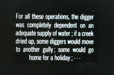
Slide - DIGGERS & MINING. GETTING THE GOLD, c1850
Diggers & Mining. Getting the Gold. Slide: For all these operations, the digger was completely dependent on adequate supply of water; if a creek dried up, some diggers would move to another gully; some would go home for a holiday; Markings: 68 994.LIF:4. Used as a teaching aid.hanimounteducation, tertiary, goldfields -
Tarnagulla History Archive
Photograph - Children at Murphy's Creek School, c.1950s
A small monochrome photograph depicting a group of nine children who are students of Murphy's Creek school. Back row: Trevor & Colin Clark Middle row: Neville Oxley, June Silke, Marion Silke, Wendy Hancock Back row: Glenys Evans, Beryl Silke, Pam Evans -
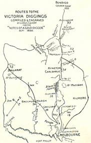 Ballarat Heritage Services
Photograph - Plan, Routes to the Victoria Diggings, 1852
Black and white line drawing of the route to the major Central Victorian Diggings, including Ballarat, Bendigo, Jim Crow (Daylesford), Kyneton, Carlshrue, Mount Macedon, Kilmore, Jackson's Creek, Keilor, Bacchus Marsh, Gregory, Black Forest, Geelong, Flemington, Melbourne, Mount Buninyong, Port Phillip. ballarat, bendigo, jim crow, daylesford, kyneton, carlshrue,, mount macedon, kilmore, jackson's creek, keilor, bacchus marsh, gregory, black forest, geelong, flemington, melbourne, mount buninyong, port phillip, diggings, thomas ham, goldfields -
 Lakes Entrance Regional Historical Society (operating as Lakes Entrance History Centre & Museum)
Photograph, 1999
This hall was originally at Tostaree where it was opened in 1919 as State School no. 3994, worked part time with Upper Hospital Creek, Canni Creek. Later used as a public hall for meetings, dances etc. When no longer being used it was donated to Nowa Nowa RSL as clubrooms, later became CWA Hall, finally in mid 1990's fitted out as Recreation Centre.Colour photograph of the Gym at Nowa Nowa. Officially the Nowa Nowa Health and Fitness Centre, a small timber half, corrugated iron gable roof, short ramp leading to roofed veranda across front entry. Nowa Nowa Victoriahouses -
 Orbost & District Historical Society
black and white photograph, 1920's -1930s
The photograph shows the wagon and team owned by Mr Tom Malinn of Sardine Creek. On lst Juy 1926, Tom Malin took over the horse drawn coach run from Orbost to Delegate. After a few years he obtained an International 2-3 ton truck. On his first trip to Bendoc he did not carry mail, but brought Miss Cunning, the first lady head teacher and collected ballot boxes. On his next trip (March 1930) he made history as the first mailman on this route to deliver mail in a motor vehicle. (info. Bendoc History) Tom and Sophie Malinn farmed at Martin’s Creek. Sophie (nee Jensen) married Tom Malinn in 1926. Sophie’s family had run the historic “Danebo Hotel” at Martin’s Creek for many years, and in 1931, Tom and Sophie began farming at Martin’s Creek, initially cropping maize and beans. This is a pictorial history horse-drawn transport used widely in Orbost until the late 1920sA black / white photograph of a large wagon loaded with wool bails being pulled by a team of horses. a man is standing behind the horses in the background.on back -"Tom Malinn with wool from Bonang"malinn-tom-bonang transport-horse-drawn -
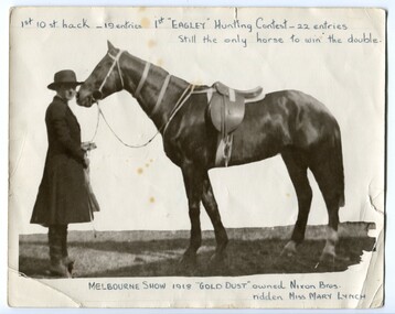 Orbost & District Historical Society
black and white photograph, 1918
Mary Lynch was the daughter of Matthew and Mary (nee Loorham) Lynch. She became Mrs Ivell. she was a noted horse-woman having ridden the Nixon Bros hack, "Gold Dust" at the Melbourne Show coming first in the 10 stone hack and first in the Eagley Hunting Contest. (info. Mary Gilbert) Horse racing was a popular past-time in early Orbost. The Nixon family was involved through Keith Nixon. Some of the earliest horse races were held on a course in a paddock belonging to Mr James Cowell at Jarrahmond. For a long time horse races were part of the Marlo Picnic Races.This item is connected to an activity once popular in the Orbost district. The Nixon family were prominent early settlers in the Orbost district.A black / white photograph of a lady dressed in a a tailored hip coat, bowler hat, knee breeches and boots. She is holding the reins of a saddled horse. There is a copy.on front at top - " 1st 10st hack - 19 entries 1st "EAGLEY" Hunting Contest - 22 entries. Still the only horse to win the double." on front at bottom - " MELBOURNE SHOW 1918 "GOLD DUST" owned by Nixon Bros ridden by Miss MARY LYNCH"lynch-mary nixon-bros-horses equestrian melbourne-show gold-dust -
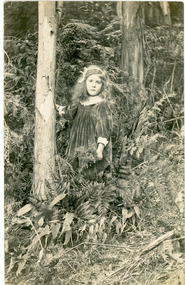 Mt Dandenong & District Historical Society Inc.
Photograph
Photograph shows a young Ivy Child, possibly 5 or 6 years old posing for a photograph in the bush. Ivy is very well dressed and groomed. Ivy May Child (1910 – 1989) was the daughter of Arthur Edward (Ted) Child (1878 – 1964) and Ethel May Madden (1888 – 1970). Ted Child was the son of Matthew Francis Child (1839 – 1933) and Martha Jeeves (1857 – 1926). He was the grandson of one of the early pioneers Francis Child. Ivy grew up on the family property on Childs Road and took many photographs. Ivy married Henry William Burgess (1906 – 1968) in 1944.Black and white photograph of a young girl with long hair posed beside a tree in a bush setting. The girl is wearing a long sleeved velvet dress with a white collar and cuffs.ivy child, ivy may child, bush -
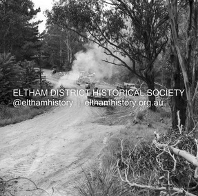
 Eltham District Historical Society Inc
Album - Photograph, J.A. McDonald, Black Cameron Road, Smiths Gully, Aug. 1962
Black Cameron Road Bridge over Salters Rush Creek following bush fires 15-16 Jan. 1962Record of various Shire of Eltham infrastructure works undertaken during the period of 1952-1962 involving bridge and road reconstruction projects, sometimes with Eltham Shire Council Project Reference numbers quoted. It was during this period that a number of significant improvements were made to roads and new bridges constructed within the shire that remain in place as of present day (2022). In many situations, the photos provide a tangible visible record of infrastructure that existed throughout the early days of the Shire. The album was put together by or under the direction of the Shire Engineer, J.A. McDonald.H941 stamped on reverse (film processing #)infrastructure, shire of eltham, bridge construction, road construction, 1962-08, bushfires, victorian bushfires - 1962, black cameron road, smiths gully -
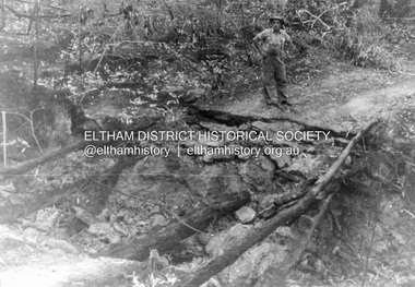
 Eltham District Historical Society Inc
Negative - Photograph, J.A. McDonald, Heidelberg-Kinglake Road, Oct. 1959
Job 56M431 Contractors Wolf and Wood Yow Yow Creek Bridge Bypass road and bridge finished October 1959Record of various Shire of Eltham infrastructure works undertaken during the period of 1952-1962 involving bridge and road reconstruction projects, sometimes with Eltham Shire Council Project Reference numbers quoted. It was during this period that a number of significant improvements were made to roads and new bridges constructed within the shire that remain in place as of present day (2022). In many situations, the photos provide a tangible visible record of infrastructure that existed throughout the early days of the Shire. The album was put together by or under the direction of the Shire Engineer, J.A. McDonald.infrastructure, shire of eltham, bridge construction, heidelberg-kinglake road, 1959-10, road construction, scan - 120 format 6x6 negative, yow yow creek -
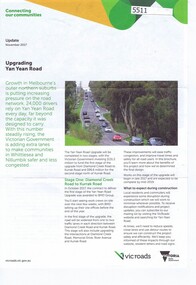 Greensborough Historical Society
Pamphlet, Upgrading Yan Yean Road, 2017_11
VicRoads let a contract for the upgrade of Yan Yean Road between Diamond Creek Road and Kurrak Road in October 20174p. text and col. photographs and plan.yan yean road -
 Greensborough Historical Society
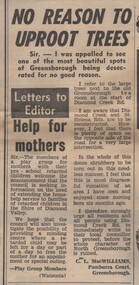
Newspaper Clipping - Digital Image, No reason to uproot trees, 21/08/1973
A Letter to the Editor complaining about the removal of trees near the corner of Diamond Creek Road and St Helena Road [1973] Digital copy of newspaper article, black text.diamond creek road, st helena road greensborough