Showing 22282 items
matching parks
-
 Surrey Hills Historical Society Collection
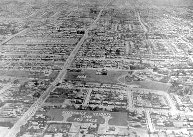
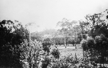
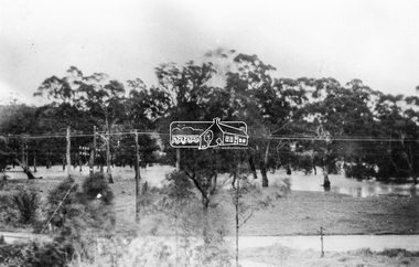
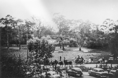
Photograph - Aerial view Riversdale Heights Estate area, c1923
This was probably part of a real estate promotion for the sale of the Riversdale Heights Estate. This was subdivided by Messrs. Duncan and Weller. Of the allotments offered, 30 were sold and realised £4600. Date of this sale was c December 1923. This suggests that the date This are was one of the last pieces of former rural land to be sub-divided for housing in Surrey Hills.The land between it and South Surrey Park was sub-divided post WW1, hence the naming of the streets after sites of WW1 battles.A black and white reproduction of an aerial photo of the area near the corner of Warragul and Riversdale Roads looking west towards the city. Some features have been identified by name including the Riversdale Heights Estate, which was being sub-divided. North and South Courts are shown. Other roads (unmarked) in the foreground are Graham Street, Allie Street, Thistle Street, Lille Street, Amiens Street, and Marne Street. Beyond these is the area marked 'PARK' (South Surrey Park), which is devoid of vegetation. Areas of Camberwell and Canterbury are also shown. The area covered extends to beyond St Dominic's Church. The original is mounted on a cream deckle-edged paper.Beneath the original on the mount: "SOUTH SURREY HILLS LOOKING WEST c. 1936" [The reference to the sale in the Box Hill Reporter of December 1923 found on Trove suggests that this date is not accurate.] Rear top LH corner of original in Jocelyn Hall's handwriting: "For Centre / from Mr James Long"riversdale heights estate, riversdale road, allie street, south surrey park, lille street, thistle street, amiens street, marne street, south court, north court, duncan and weller, real estate sales, graham street, st dominics church, highfield park, canterbury primary school, aerial photo -
 Melbourne Tram Museum
Document - Research Notes, H. S. McComb, extracts from the HTT Annual reports, 1950's
Set of papers - 28 sheets giving extracts from the HTT Annual reports - hand written in ink on plain quarto paper. - Notes the closing date of the horse tramway as 31/1/16 - whether to delegate operation to PMTT - Wattle Park - Metropolitan Tramway Park - Riversdale Road extension - Construction of the tramway, contracts and issues - Opening of the Line - extension of the depot - New tramcars - Burwood Accident - Report of Engineer and Manager - Permanent Way issues - Overhead Items 2037 to 2041 within box 72.3 in a brown folder marked "Hawthorn Tramway Trust" in red pencil. See Reg Items 2364 to 2367 for copies of the original reports.trams, tramways, htt, hawthorn, reports, annual reports, pmtt, wattle park, riversdale rd, construction, hawthorn depot, track, overhead -
 Eltham District Historical Society Inc
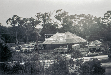
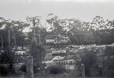
Slide - Photograph, Grace Mitchell, Ashtons Circus set up in Bremner's Reserve, Main Road, Eltham, c.1955
View from Grace Mitchell's shop at the corner of Mount Pleasant Road and Main Road. Grace Mitchell was probably best known for her Eltham shop at the corner of Mt Pleasant Road and Main Road. Grace's memories covered many local identities who were patrons of her shop between 1954 and 1971. From the elevated position of her shop and home Grace was able to view a varied passing parade of Eltham events from ERSILAC, Easter and Eltham Festival parades passing on their way to Eltham Lower Park, circuses in Wingrove Park (then Bremner’s Reserve), roadworks and other happenings. Bremner's Reserve was renamed Wingrove Park c.1970 This photo was from a series of images presented by Grace Mitchell at a Society talk 10 March 1993 on the theme of “My Eltham”.35mm Kodak 5052 TMX Black and White transparency, 1 strip, 6 frames Black and white print 17 x 25.4 cmashtons circus, bremner's flat, circus, grace mitchell, main road, mount pleasant road, wingrove park -
 Eltham District Historical Society Inc
Photograph, Grace Mitchell, Bremners Flat, Main Road, Eltham, 1958c
View from Grace Mitchell's shop at the corner of Mount Pleasant Road and Main Road. Grace Mitchell was probably best known for her Eltham shop at the corner of Mt Pleasant Road and Main Road. Grace's memories covered many local identities who were patrons of her shop between 1954 and 1971. From the elevated position of her shop and home Grace was able to view a varied passing parade of Eltham events from ERSILAC, Easter and Eltham Festival parades passing on their way to Eltham Lower Park, circuses in Wingrove Park (then Bremner’s Reserve), roadworks and other happenings. Bremner's Reserve was renamed Wingrove Park c.1970 This photo was from a series of images presented by Grace Mitchell at a Society talk 10 March 1993 on the theme of “My Eltham”.Black and white print 17 x 25.4 cmbremner's flat, main road, mount pleasant road, wingrove park -
 Eltham District Historical Society Inc
Photograph, Grace Mitchell, Diamond Creek in flood, Bremners Flat, Main Road, Eltham, c.1958
View from Grace Mitchell's shop at the corner of Mount Pleasant Road and Main Road. Grace Mitchell was probably best known for her Eltham shop at the corner of Mt Pleasant Road and Main Road. Grace's memories covered many local identities who were patrons of her shop between 1954 and 1971. From the elevated position of her shop and home Grace was able to view a varied passing parade of Eltham events from ERSILAC, Easter and Eltham Festival parades passing on their way to Eltham Lower Park, circuses in Wingrove Park (then Bremner’s Reserve), roadworks and other happenings. Bremner's Reserve was renamed Wingrove Park c.1970 This photo was from a series of images presented by Grace Mitchell at a Society talk 10 March 1993 on the theme of “My Eltham”.Black and white print 17 x 25.4 cmbremner's flat, diamond creek, floods, main road, mount pleasant road, wingrove park -
 Eltham District Historical Society Inc
Slide - Photograph, Grace Mitchell, Portable buildings on trucks possibly for installation at the Golden Fleece Service Station, corner of Main Road and Mount Pleasant Road, Eltham, c.1961
View from Grace Mitchell's shop at the corner of Mount Pleasant Road and Main Road. Grace Mitchell was probably best known for her Eltham shop at the corner of Mt Pleasant Road and Main Road. Grace's memories covered many local identities who were patrons of her shop between 1954 and 1971. From the elevated position of her shop and home Grace was able to view a varied passing parade of Eltham events from ERSILAC, Easter and Eltham Festival parades passing on their way to Eltham Lower Park, circuses in Wingrove Park (then Bremner’s Reserve), roadworks and other happenings. Bremner's Reserve was renamed Wingrove Park c.1970 This photo was from a series of images presented by Grace Mitchell at a Society talk 10 March 1993 on the theme of “My Eltham”.35mm Kodak 5052 TMX Black and White transparency, 1 strip, 6 frames Black and white print 17 x 25.4 cmgolden fleece service station, main road, mount pleasant road -
 Eltham District Historical Society Inc
Photograph, Grace Mitchell, Possibly the Ersilac Parade travelling along Main Road, Eltham, c.1958
View from Grace Mitchell's shop at the corner of Mount Pleasant Road and Main Road. Grace Mitchell was probably best known for her Eltham shop at the corner of Mt Pleasant Road and Main Road. Grace's memories covered many local identities who were patrons of her shop between 1954 and 1971. From the elevated position of her shop and home Grace was able to view a varied passing parade of Eltham events from ERSILAC, Easter and Eltham Festival parades passing on their way to Eltham Lower Park, circuses in Wingrove Park (then Bremner’s Reserve), roadworks and other happenings. Bremner's Reserve was renamed Wingrove Park c.1970 This photo was from a series of images presented by Grace Mitchell at a Society talk 10 March 1993 on the theme of “My Eltham”.Black and white print 17 x 25.4 cmcars, bremner's flat, eltham, ersilac parade, main road, mount pleasant road, wingrove park, festival, horse drawn carriage -
 Eltham District Historical Society Inc
Photograph, Grace Mitchell, Possibly the Ersilac Parade travelling along Main Road, Eltham, 1958c
View from Grace Mitchell's shop at the corner of Mount Pleasant Road and Main Road. Grace Mitchell was probably best known for her Eltham shop at the corner of Mt Pleasant Road and Main Road. Grace's memories covered many local identities who were patrons of her shop between 1954 and 1971. From the elevated position of her shop and home Grace was able to view a varied passing parade of Eltham events from ERSILAC, Easter and Eltham Festival parades passing on their way to Eltham Lower Park, circuses in Wingrove Park (then Bremner’s Reserve), roadworks and other happenings. Bremner's Reserve was renamed Wingrove Park c.1970 This photo was from a series of images presented by Grace Mitchell at a Society talk 10 March 1993 on the theme of “My Eltham”.Black and white print 17 x 25.4 cmcars, bremner's flat, eltham, ersilac parade, main road, mount pleasant road, wingrove park, festival, horse drawn carriage -
 Eltham District Historical Society Inc
Photograph, Grace Mitchell, Possibly the Ersilac Parade travelling along Main Road, Eltham, c.1958
View from Grace Mitchell's shop at the corner of Mount Pleasant Road and Main Road. Grace Mitchell was probably best known for her Eltham shop at the corner of Mt Pleasant Road and Main Road. Grace's memories covered many local identities who were patrons of her shop between 1954 and 1971. From the elevated position of her shop and home Grace was able to view a varied passing parade of Eltham events from ERSILAC, Easter and Eltham Festival parades passing on their way to Eltham Lower Park, circuses in Wingrove Park (then Bremner’s Reserve), roadworks and other happenings. Bremner's Reserve was renamed Wingrove Park c.1970 This photo was from a series of images presented by Grace Mitchell at a Society talk 10 March 1993 on the theme of “My Eltham”.Black and white print 17 x 25.4 cmcars, bremner's flat, eltham, ersilac parade, main road, mount pleasant road, wingrove park, festival, horse drawn carriage -
 St Kilda Historical Society
Ephemera - Ticket, Picnic to Park Orchards, 1936
Ticket to picnic at Park Orchards on 21 December 1936, organised by the St Kilda Unemployed Organisation with the support of the St Kilda City Council, Mayor (Cr Alfred Levy), Archie Michaelis MLA, and 'other well-known gentlemen'. The ticket appears to have been perforated to allow vouchers, printed on the back (for bus, dinner, toys, stockings, ice cream and tea) to be separated and used. Park Orchards is a residential suburb 23km north east of Melbourne that was created in 1925 on land used for orchards when timber merchants Australis Sharp and John Taylor launched the Park Orchards Country Club estate. Buyers were not attracted to the estate, and for many years all that existed were a clubhouse and various sporting facilities. It gained popularity when demand for housing surged in the 1950s.Grey/green coloured card, printed in blue on both sides and with 5 evenly spaced lines of perforations across the width.st kilda unemployed organisation, st kilda council -
 Ballarat Tramway Museum
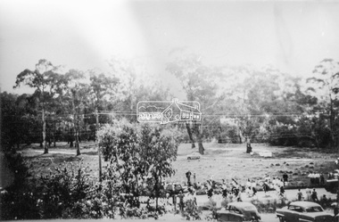
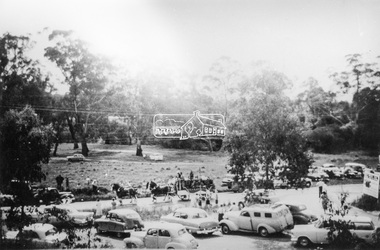
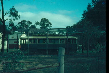
Slide - 35mm slide/s - set of 8, John Theodore, Tram No. 32 at the Maryborough, post March 1973
Series of photos of Tram No. 32 at the Maryborough Historical and Wildlife Co-op park, after transport to the park post March 1973. Tram transported to Maryborough 3/73, see Reg Item 953. Slide 1 - after the building to cover the tram has been constructed, but not roofed. Slides 2 and 3 are prior to the shelter being built. .1 - at the park, with the frame of the building erected, has other buildings in the background. .2 - ditto, but before the frame erected. .3 - ditto, showing the short piece of track that the tram was placed on. .4 - Interior view .5 - ditto .6 - ditto .7 - ditto .8 - showing motor with a trolley pole based wedged inside. See also Reg item 6632 for another photograph of the series. Yields information about tram 32 following its disposal and how it was sheltered.Set of 8 AGFA blue and white plastic mount 35 x 23mm or 27mm square slidesVarious notations by John as to the slide number and the trams in pencil and ink.tramways, trams, disposal, maryborough, tram 32 -
 Bendigo Military Museum
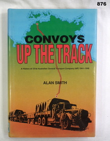
Book, Alan Smith, Convoys Up the Track, 1991
Book, hard cover with dust cover, 300 pages. Dust cover shows a simple map of Northern Territory with a red road from Alice Springs to Darwin. Print is black & red ink. Image at bottom shows 2 parked trucks with drivers. Illustrated with photos, maps & charts.Donated by Bgo Y's Men's Club On fly leaf: To ??? best wishes Alan Smithbooks, military, history -
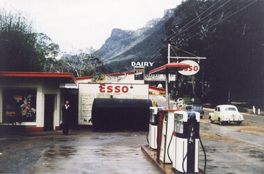 Halls Gap & Grampians Historical Society
Photograph - Coloured, C 1960
The proprietor standing in front of the Esso garage. Probably taken at the same time as record 252 (as the yellow car appears to be in the same spot).Photo shows a man standing in front of an Esso garage building. There are petrol pumps in the foreground. A yellow early model Holden and a blue station wagon are parked on the road in the right of the Picture. General Store and Dairy signs can be seen behind the garage and the Wonderland Range can be seen in the background.buildings, shops -
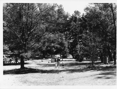 Halls Gap & Grampians Historical Society
Photograph - B/W, C 1960s (?)
This is a photo of Zumsteins picnic area (before the pine trees were removed).The photo shows a woman walking in a picnic area, holding the hand of a toddler and a little girl. On the far left a person is sitting at a picnic table under a tree. A Vauxhall car is parked beside the table. The area has a large number of trees, some of which are non-native pine trees.scenery, zumsteins -
 Ringwood and District Historical Society
Documents, 1997 Bushland Management Plans for BJ Hubbard Reserve, Wombolano Park, Loughie's Bushland, and weed control monitoring sheet
Five Bushland Management Documents 1. Bushland Reserve Management Plan 2. Weed Control Monitoring Sheet 3. BJ Hubbard Reserve - Bushland Management Plan 1997 4. Wombolano Park - Bushland Management Plan 1997 5. Loughie's Bushland Management Plan 1997 -
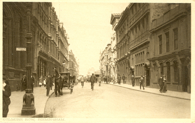 Federation University Historical Collection
Postcards, Birmingham
Two black and white postcards of Birmingham. .1) Bull Ring, Birmingham featuring a church and steeple in the mid background and people waling in the streets. .2) Colmore Row, Birmingham featuring three storey buildings on either side of a road. People walk on the footpath and a horse and carriage are parked on the left. -
 Federation University Historical Collection
Book, Minute Book of the Ballarat School of Mines Science and Field Naturalists Club, 1915-1918, 8 May 1915 - October 1918
This minute book records the reformed Science and Field Naturalists Club of the Ballarat School of Mines. Such a club had existed in 1888 and 1889. Final recorded meeting took place on 17th November 1918, resolved that "there would be no further meeting of the Club until further notice was given." (Ballarat School of Mines Annual Report of 1888, p.17. Also mentioned in Annual Report 1889, p.195)Dark blue hard-cover minute book with dark red spine. 186 numbered lined pages with left hand margin. Last entry on p.128. Courier Newspaper article 'Victorian National Park: Our Fauna and Fauna' by Charles Hoadley published 16/06/1915 Included: State Savings Bank of Victoria account booklet No. 128.155, issued to School of Mines Science and Field Naturalists Club.ballarat school of mines, smb, science and field naturalists club, fenner, charles fenner, albert w. steane, william baragwanath, john brittain, lal lal, lal lal excursion, science nad field naturalists club, ballarat field naturalists wild flower show, maurice copland, alfred mica smith, sunnyside woollen mill excursion, wilson's promontory, charles hoadley -
 Bendigo Historical Society Inc.
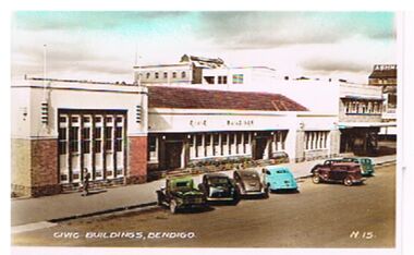
Photograph - CIVIC BUILDINGS, BENDIGO
Photograph: Civic Buildings, Hargreaves Street, Bendigo. Image, hand tinted, shows brick building, white rendered top, tile roof. Civic Buildings on front. Cars parked on kerb outside. Ashman sign on Rh side in background. Written on bottom ' Civic Buildings, Bendigo, No. 15'bendigo, buildings, civic buildings, bendigo, civic buildings, ashman's -
Port Melbourne Historical & Preservation Society
Flyer, Victorian Railways, Sandridge Rail Trail, 2005
Fold out flyer with black and white picture of train and three men on front cover. Back cover coloured image from Latrobe picture collection of park-like setting with steam train in background. Fold out section has history of railway, map, walk and ride descriptionstransport - railways, recreation, piers and wharves - station pier, piers and wharves - railway pier, hobson's bay railway company, melbourne and hobson's bay united railway company, montague street station, golden fleece hotel, st barnabas anglican church, north port station, lord raglan hotel -
 Port Melbourne Historical & Preservation Society
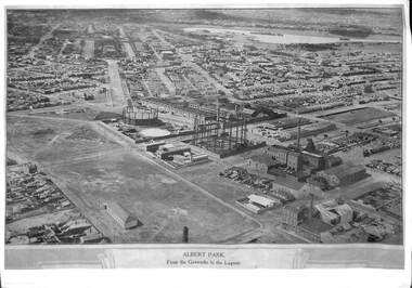
Photograph, E C Joshua, Albert Park from the Gasworks to the Lagoon, 1921
Rare copy of E C JOSHUA and Captain LARKIN work."Albert Park from the Gasworks to the Lagoon" Copy of aerial photography 1921 of former lagoon area taken by E C JOSHUA (photographer) and Captain H J LARKIN (pilot). "Views from an Aeroplane" black and white copy. Plus separate sheet giving brief description of photographtransport - aviation and aerodrome, sandridge lagoon, natural environment, recreation, built environment, parks and gardens, e c joshua, h j larkins, gasworks, schumaker mill furnishing works, pump house, sugar shed, joshua bros distillery -
 Bendigo Historical Society Inc.
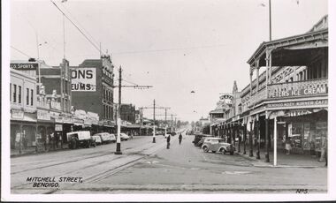
Photograph - MITCHELL STREET BENDIGO
Photograph - black and white. Photo of Mitchell Street, right hand side Bendigo Kozy Korner Café, Photo No.5. Small convertible car parked in gutter to the right. Vehicle with white canopy and men unloading goodsto the left. Peters Ice Cream sign bottom right corner.place, streetscape, mitchell street, bendigo, mitchell street bendigo. -
 Stawell Historical Society Inc
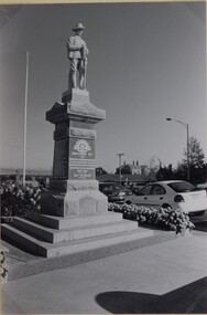
Photograph, Soldiers’ Memorial World War 1 in Main Street 1999
Soldiers’ WW1 Memorial Stawell. The photograph was taken in 1999.Two black & white photos of the Soldiers WW1 Memorial taken in c.1999. Of the two photos one is larger than the other. The photo shows the memorial surrounded on three sides by garden beds with a flagpole behind the memorial. Two cars can be seen parked by the memorial with houses in the background.stawell ww1 ww2 -
 Whitehorse Historical Society Inc.
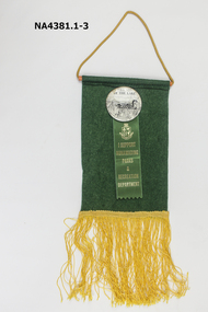
Badge - Badge on Banner, c.1985
See Ref NA4362Green felt pennant with a badge of 'Friends of the Lake' attached. The pennant also has a ribbon pinned under the lake badge, Supporting Nunawading Parks and Recreation Department. The writing and insignia on the ribbon is gold on green ribbon. The pennant has gold cord to hang and gold fringe stitched to the base.civic mementoes, souvenirs, trophies & awards, education -
Whitehorse Historical Society Inc.
Article, Morack compares favourably, 1992
Nunawading Parks and recreation Services have just completed a survey and found that City of Nunawading's Morack Golf Course compares favourably with similar courses around Melbourne.Nunawading Parks and recreation Services have just completed a survey and found that City of Nunawading's Morack Golf Course compares favourably with similar courses around Melbourne. the course is one of only six which cater for disabled people and provides a professional golfer for private groups, clinics and the disabled.Nunawading Parks and recreation Services have just completed a survey and found that City of Nunawading's Morack Golf Course compares favourably with similar courses around Melbourne.golf, morack golf course, city of nunawading . parks and recreation services, mcdade, denis, mcintosh, david -
Whitehorse Historical Society Inc.
Article, {pioneers were on the ball, 1983
The recent opening of the very first public tennis courts in Nunawading has stirred memories of the district's tennis pioneers.The recent opening of the very first public tennis courts in Nunawading has stirred memories of the district's tennis pioneers. The former Nunawading Park Tennis club was established near the Canterbury - Middleborough Roads corner more than 60 years ago. Photos of club members in 1919 & 1920.The recent opening of the very first public tennis courts in Nunawading has stirred memories of the district's tennis pioneers. tennis, nunawading park tennis club, boyce-gibson, alec, paton, burton, figgis, alan, macmahon ball, w., davies, dave -
 Whitehorse Historical Society Inc.
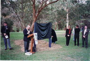
Photograph, Opening of Whitehorse Heritage Trail, 2/07/2001 12:00:00 AM
Heritage Trail funded by grant to the City of Whitehorse from Commonwealth of Australia to celebrate 100 years of Federation.Coloured photograph of Phillip Baressi, MHR for Deakin, unveiling the Display Panel at opening of Whitehorse Heritage Trail at Furness Park, Maine Road Blackburn.On left: Cr Bill Bowie, Mayor of Whitehorse.|On right: Cr. Kaele Way, Geoff Pascoe, City of Whitehorse and Cr Peter Allen.whitehorse heritage trail, city of whitehorse, baressi phillip, bowie, bill, way, kaele, pascoe, geoff, allan, peter -
 Whitehorse Historical Society Inc.
Photograph, Grace Begg
Black and white photo of Grace Begg, born 15/9/1857, married Russell Scott Thomas 17/8/1890 at Heathcote, Victoria. Lived at Albert Park. Grandmother of Russell Alexander, Creek Road, Mitcham. (Russell's Menswear, Whitehorse Road, Mitcham). Cross Ref: NA2693.begg, grace, alexander, russell, stan russell menswear -
 Bendigo Historical Society Inc.
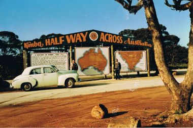
Photograph - PETER ELLIS COLLECTION: PETER ELLIS AND JOHN MEREDITH
Colour photo of Peter Ellis and John Meredith standing in front of the sign at Kimba Half Way Across Australia. There are three signs, one has the History of Kimba, one is a map of Australia and the other is a map with Spencer Gulf printed on it. A green Holden car is parked in front of the History sign.photo, group, male, peter ellis collection, peter ellis, john meredith -
 Ballarat Tramway Museum
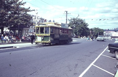
Slide - 35mm slide/s, c1962
Tram 28 at the intersection of Sturt and Lydiard Streets, with destination Gardens via Sturt St. West, two inspectors by tram, many people sitting on park benches in centre median strip. Tram with lights, but small white strip, has early 'Twin Lakes' sign on front of tram.'F' in blue inktramways, trams, sturt st, tramway centre, lydiard st, tram 28