Showing 1355 items
matching a urban
-
 Kew Historical Society Inc
Photograph - Flooding of the Yarra River in North Kew, 1934
North Kew, now divided between Kew and Kew East, bordered the Yarra River. As such, it was a region subject to flooding in the Yarra Valley. Development beyond this point (ie Kellett Grove) was limited by the City of Kew's planning regulations. Prior to urban development, the area since European settlement and the first land sales in the district in the 1840s, had been used for dairy farming. .Small sepia snapshot of the devastation caused by the 1934 flood.The photo was taken in the vicinity of Kellett Grove, North Kew and includes the roof of Chipperfield's Boathouse as well as other local houses.Verso: THIS IS CHIPPERFIELD'S BOAT SHEDS & COES & WILLIAMS TAKEN FROM OUR STREET / 1934yarra river -- north kew, floods -- yarra valley, floods -- north kew, floods -- 1934, natural disasters -- kew, chipperfields boathouse -
 Bendigo Historical Society Inc.
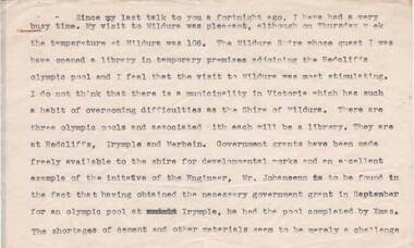
Document - NORMAN OLIVER COLLECTION: SPEECH NOTES 1949-1971
The Norman Oliver collection. Norman Oliver was three times Mayor of Bendigo - 1950-51, 1964-65, 1970-71. Sixteen typed pages of speech notes. In the format of his talks for 3BO 'The Mayor Speaks'. Untitled and undated, though references suggest 1951. Corrections in red ink. Topics include: visit to Mildura, council public works, the showgrounds, urban bus fares and taxis, music for the people, the Benevolent Home Appeal, Nurses Graduation ceremony, the opening of the legal year, and the state development committee.bendigo, council, speech notes, norman joseph oliver , councillor norman oliver. mayor of bendigo. 3bo 'the mayor speaks'. -
 Bendigo Historical Society Inc.
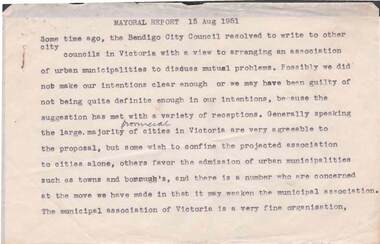
Document - NORMAN OLIVER COLLECTION: SPEECH NOTES 15 AUGUST 1951
The Norman Oliver collection. Norman Oliver was three times Mayor of Bendigo - 1950-51, 1964-65, 1970-71. Fourteen pages of typed notes headed Mayoral Report 15 Aug 1951. In the format he used for his talks on 3BO 'The Mayor Speaks'. Corrections in blue ink. Topics include : a proposed association of urban municipalities, Crown lands regulations, the School for Deaf Children, taxis, Kangaroo Flat bus route, the cattle markets, sewerage extensions, the Library, and Education Week.bendigo, council, speech notes, norman joseph oliver , councillor norman oliver. mayor of bendigo. 3bo 'the mayor speaks'. school for deaf children. -
 Bendigo Historical Society Inc.
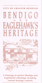
Document - LONG GULLY HISTORY GROUP COLLECTION: BENDIGO AND EAGLEHAWK'S HERITAGE
Cream coloured brochure providing a brief explanation of the findings of the Bendigo and Eaglehawk Heritage Study and some of the recommendations for preserving Bendigo's heritage for the future. Headings are: Bendigo's Heritage, Heritage Controls - Benefits and Potential Effects, Advice and Financial Assistance, New Conservation Controls for Significant Historic Buildings and Precincts, Feature of the Controls, Types of Controls Proposed, Individually Significant Buildings and Heritage Precincts. On the back: Proposed Urban Conservation Precincts for Bendigo and Eaglehawk. California Gully, Harvey Town and Virginia Hill are included in the Eaglehawk area.bendigo, history, long gully history group, the long gully history group - bendigo and eaglehawk's heritage, city of greater bendigo, heritage advisory committee, bart 'n' print -
 Kew Historical Society Inc
Map, MMBW, MMBW Plan No.39 Kew & Heidelberg, 1900-1910
The Melbourne and Metropolitan Board of Works (MMBW) was established by an act of the Victorian Parliament in 1890 to prepare for and to implement a sewerage and water reticulation system across what was then inner Melbourne, its surrounding and middle distance suburbs, including Kew. The MMBW was disbanded in 1991.The map collection of the Kew Historical Society has at its core the historic maps assembled and originally stored in the City Engineer's Department of the City of Kew. These include maps in a number of scales. The vast majority of maps were produced by the MMBW in the first two decades of the twentieth century, and are solid working maps, backed by linen for durability. These maps are historically significant to Kew, the City of Boroondara and to the history of the development of state utilities in Victoria. A number of the Kew maps have additional details added by former municipal officers, including the levels reached by various floods. As these were working documents, information was added to them long after the period of their initial production and distribution.Early map of part of the Borough of Kew, created in the first decade of the twentieth century, at a scale 160 ft to 1 inch. The map covers what was then the north western section of Kew, bordered on its north by Wills Street and the Kew Lunatic Asylum, in the west by the River Yarra [and the later added Yarra Boulevard] , by Princess Street in the East and Holroyd Street in the south. The map shows the extent of urban development by that time, prominent institutions and the outlines of built structures in the municipality. Contour lines were added in ink to the map at a later stage.MELBOURNE AND METROPOLITAN BOARD OF WORKS / PLAN NO. 39 / KEW & HEIDELBERGmelbourne & metropolitan board of works, mmbw maps, mmbw plans, borough of kew, cartography -
 Kew Historical Society Inc
Map, MMBW, MMBW Plan No.67 Kew, 1900-1910
The Melbourne and Metropolitan Board of Works (MMBW) was established by an act of the Victorian Parliament in 1890 to prepare for and to implement a sewerage and water reticulation system across what was then inner Melbourne, its surrounding and middle distance suburbs, including Kew. The MMBW was disbanded in 1991.The map collection of the Kew Historical Society has at its core the historic maps assembled and originally stored in the City Engineer's Department of the City of Kew. These include maps in a number of scales. The vast majority of maps were produced by the MMBW in the first two decades of the twentieth century, and are solid working maps, backed by linen for durability. These maps are historically significant to Kew, the City of Boroondara and to the history of the development of state utilities in Victoria. A number of the Kew maps have additional details added by former municipal officers, including the levels reached by various floods. As these were working documents, information was added to them long after the period of their initial production and distribution.Early map of part of the Borough of Kew, created in the first decade of the twentieth century, at a scale 160 ft to 1 inch. The map covers what was then the north central part of Kew, bordered on its north by the Outer Circle Railway Spruzen and Beresford Avenues, in the west by Princess Street, in the south by High Street, and in the east by (about) Belford Road. The map shows the extent of urban development by that time, prominent institutions and the outlines of built structures in the municipality. Contour lines were added in ink to the map at a later stage.MELBOURNE AND METROPOLITAN BOARD OF WORKS / PLAN NO. 67 / KEW melbourne & metropolitan board of works, mmbw maps, mmbw plans, borough of kew, cartography -
 Kew Historical Society Inc
Map, MMBW, MMBW Plan No.68 Kew, 1900-1910
The Melbourne and Metropolitan Board of Works (MMBW) was established by an act of the Victorian Parliament in 1890 to prepare for and to implement a sewerage and water reticulation system across what was then inner Melbourne, its surrounding and middle distance suburbs, including Kew. The MMBW was disbanded in 1991.The map collection of the Kew Historical Society has at its core the historic maps assembled and originally stored in the City Engineer's Department of the City of Kew. These include maps in a number of scales. The vast majority of maps were produced by the MMBW in the first two decades of the twentieth century, and are solid working maps, backed by linen for durability. These maps are historically significant to Kew, the City of Boroondara and to the history of the development of state utilities in Victoria. A number of the Kew maps have additional details added by former municipal officers, including the levels reached by various floods. As these were working documents, information was added to them long after the period of their initial production and distribution.Early map of part of the Borough of Kew, created in the first decade of the twentieth century, at a scale 160 ft to 1 inch. The map covers what was then the north central part of Kew, bordered in the north by Oak Avenue, in the west by the Yarra River and Connor's Creek, in the south by Beresford and Carnegie Avenues, and in the east by Glass's Creek and Burke Road. The map shows the extent of urban development by that time, prominent institutions and the outlines of built structures in the municipality. Contour lines and the levels of historic floods were added in ink to the map at a later stage.MELBOURNE AND METROPOLITAN BOARD OF WORKS / PLAN NO. 68 / KEW melbourne & metropolitan board of works, mmbw maps, mmbw plans, borough of kew, cartography -
 Melbourne Tram Museum
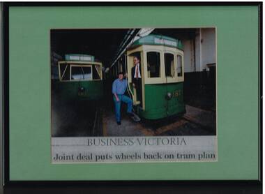
Photograph - Framed Photographs, Business Victoria, "Business Victoria - Joint deal puts wheels back on tram plan", Sep. 1999
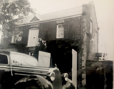
Framed photograph - metal frame, cardboard backing, light green card window mat, of Mike Ryan (VicTrack) as Project Manager for the redevelopment of the Hawthorn Tram depot and Matt Faubel of the Urban Land Corporation for The Age newspaper article titled "Business Victoria - Joint deal puts wheels back on tram plan", 13/9/1999. On the rear of the frame is a photocopy of the article. Photographed on tram 180, with 610 alongside and a photograph of the Hawthorn depot. See also Reg item 2726.2 for an associated newspaper cutting and 2726.6trams, tramways, victrack, hawthorn tram depot, reconstruction, tram 180, tram 610 -
 Melbourne Tram Museum
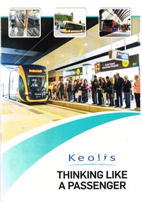
Magazine, Keolis Downer, "Keolis Thinking Like a Passenger", 2015
Booklet in magazine format, 16 A4 pages, full colour printed on gloss paper, titled "Keolis Thinking Like a Passenger", looking at Keolis's operations around the world including Melbourne and the Goldcoast. Has photos of various trams, light rail vehicles, map, locations. Includes photos of Bordeaux, Lyon, Dijon, Hyderabad, London Docklands, Lille, Melbourne, Bergen, Nottingham, Gold Coast, Stockholm (bus) and Las Vegas (bus). Published in association with the Light Railway and Transit Association for Tramways and Urban Transit in 2015.trams, tramways, keolis, light rail, melbourne, gold coast -
 Melbourne Tram Museum
Magazine, Department of Infrastructure (DOI), "New Home for Heritage Trams", Dec. 1998
Eight page magazine, folded A3 printed on gloss paper, blue and black ink, "Infrazine" - Department of Infrastructure Victoria, Issue 11, December 1998 with the main article on the redevelopment of Hawthorn Tram depot - titled "New Home for Heritage Trams". Gives details of the history of the depot, involvement of the Department of Infrastructure, Public Transport Corporation, and the Urban Land Corporation, TMSV and the future use of the heritage trams. Article signed by Brandon Mack. Other items cover legal services, the Marine Board, regional offices.trams, tramways, hawthorn depot, ptc, doi, reconstruction -
 Wangaratta Urban Fire Brigade
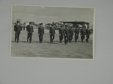
Photograph - marching team at Swanhill
Showing the participates of the Discipline March at the State Championships held at Swanhill in 1974. All the marchers were members of the Wangaratta Urban Fire Brigade. Steven Brown is the son of Les Brown. Les Brown passed away in 2011. Peter Graham and Tom Philp went on to be long serving members of the Brigade. John Briese also was a long serving member who moved to Melbourne around 1995. A black and white photograph of the Marching Team at Swanhill Championships 1974.Left to Right: Ian Moscrop, Tom Philp, John Spence, Peter Graham, Steven Brown, Les Brown, John Plecter, G Robinson, Bill Forge. Leader: John Briese Swanhill 1974photograph, marching team, swanhill -
 Federation University Art Collection
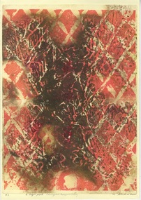
Work on paper - Artwork - Printmaking, Brendan Michael Cooper, 2016
Brendan Michael COOPER (13/5/1968 - ) Born Papua New Guinea Arrived Australia 1974. Bachelor of Visual Arts (Fine Arts) with distinction in 2016 Established printmaker and sculptor predominantly concerned with the urban and natural environment, who works with conceptual art and sacred geometry. 2018 completed an honours in Fine Arts with distinction at RMIT, and started a Masters Fine Arts at RMIT in 2019. Three limited edition prints Aluminum etching over eucalyptus transfer on 350 gsm archival Wild Letter Printing Paper brendan cooper, artwork, printmaking -
 Melbourne Tram Museum
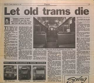
Newspaper, Herald Sun, "Let old trams die", 28/9/1993
Article by Damon Johnston about Jeff Kennett and Melbourne's W class tram future including the development of a polity for their future. The reporter notes the lack of awareness for W class trams, compared to the general tram fleet, compares performance with Z class fleet. Quotes National Trust, PTUA and Charles Sowerwine of Melb. Uni urban historian. See item 7613 for the decision News Release.Yields information the formation of a policy regarding the W class in 1993 by Government.Newspaper clipping from Herald Sun 28/9/1993tramways, w class, national trust, tramcars -
 Eltham District Historical Society Inc
Document - Folder, Census information, 1983
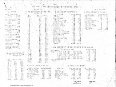
Report of population and dwelling characteristics from the 1971 Census relating to the Shire of Eltham. Comparative population statistics about the Shire of Eltham, August 1983. Historical population growth for the Shire of Eltham 1871-1981 Comparison of 1976 and 1981 populations by age group, population by urban area, age structure, number of dwellings, family type, households and more Part of Folder 75 from Harry Gilham Collection 4 A4 pages (photocopies), 2 printed A4 pages and 2 printed maps (A3) folded. 5 pages headed September, 1983population, statistics, census, shire of eltham -
 Warrnambool and District Historical Society Inc.
Booklet, Anglo-Irish Colonists in Australia, 1970s
This is a certificate issued by the Victorian Country Fire Authority to John Sizeland, a member of the Warrnambool Urban Fire Brigade. The date is 13th April 1977 and the certificate marked John (Jack) Sizeland’s retirement from the Warrnambool Fire Brigade after more than 37 years’ service (the certificate is exact – 37 and five-twelfths years). In our collection we have Jack Sizeland’s Fire Brigade uniform and accessories. This certificate is of interest because it documents the years of service of a Warrnambool identity, John Sizeland. This is a 1977 certificate issued by the Country Fire Authority to John Sizeland. It is a white sheet with a blue tinge around the edges. It has the emblem of the Country Fire Authority, the name of the Authority in a cream, yellow and black ornate setting and printing in black and yellow. There are three signatures (blue ink) on the certificate. Three signatures – P. Ea….., C. Howe, J. Allen warrnambool urban fire brigade, john sizeland, history of warrnambool -
 Ballarat Tramway Museum
Administrative record, Victorian Government, "Victorian Government Gazette - No. 32", March 1929
Victorian Government Gazette No. 32 of 20/3/1929 on pages 1081 to 1085 detailing the By-Laws and Regulations No. 58 pursuant to the Sections 9 and 46 of the Motor Omnibus Act (Urban and Country) No. 3570, of 1927 detailing the operational requirements for buses in Bendigo. Provides definitions, fares, timetables, and passengers. The regulations detail the routes, timetables, and advertising matter. A similar set of regulations are provided for the Mildura bus service. Yields information about the Bendigo bus regulations of 1929 for Bendigo.Document - 56 foolscap pages, off white paper stapled on the left hand edge.ESCo dated stamp of 16 Apr 1929buses, bendigo, museums omnibuses, regulations, bus services -
 Federation University Art Collection
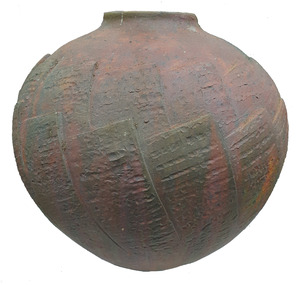
Ceramic - Artwork - Ceramics, High Rise by Grant Finck, c1987
Grant FINCK Grant Finck graduated from the Victorian College of the Arts in 1991. He started a professional career as a sculptor and ceramicist in the late 1970s, From 1993 Finck coordinated and was a design participant in a regionally based urban design program. From 1996 he has completed a substantial number of public sculpture commissions. In 1987 Grant Finck has a solo exhibition at the Switchback Gallery, Churchill.Earthernware dry glaze orb pot.ceramics, jan feder memorial ceramics collection, gippsland campus, grant finck, churchill -
 Ballarat Tramway Museum
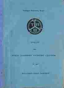
Document - TRB, Transport Regulation Board, "Enquiry into Public Passenger Transport Facilites - Ballarat", April 1968
Document of agenda for the "Enquiry into Public Passenger Transport Facilities - in the Ballarat Urban District", held April 1968. Gives the terms of reference, location, and dates, lists organisations represented, and statements of heads of the evidence in Chief by the various bodies, including Councils, SECV, ATOMEA, Trades and Labour, Murray Byrne, Chamber of Commerce, Bridge St traders, Davis Motor Services and Wilkins Busways - both by the same person.Yields information about the 1968 TRB Enquiry into the closure of Ballarat Tramways.Document - 22 quarto pages, stapled on left hand edge with blue card covers and blue tape.tramways, trb, enquiries, enquiry, ballarat, closure, davis buses, wilkins busways -
 Wodonga & District Historical Society Inc
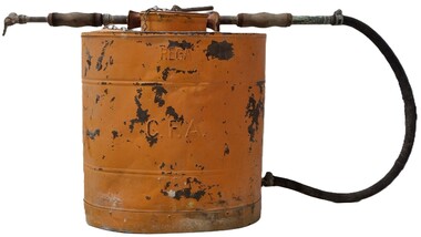
Equipment - Fire Fighting Knapsack, REGA Products Ltd, c1945
The spraying units were manufactured in Australia by REGA Products. Ltd. in 1926. They established themselves as leaders in the production of agricultural and horticultural spraying machines, including smaller knapsacks. Knapsacks were quickly adapted to a range of applications and were widely used by the C.F.A (Country Fire Authority). They were also widely used for defence during World War II. REGA was later purchased by the Garrard family and still operate as part of Garrads Pty Ltd. This sprayer was one of the units used by the C.F. A. in Wodonga. The Country FIre Authority was established in 1945 following a Royal Commission into the 1939 Black Friday fires which recommended a single firefighting authority for country Victoria, bringing together the Bush Fire Brigades, Country Fire Brigades and Forest Commission. The first fire brigade, the Wodonga Urban Fire Brigade was formed in 1891 and registered in May 1893. Since that time its volunteers have provided ongoing support to the Wodonga and District communities through events such as urban fires, bushfires and other emergency situations. This item is representative of the Wodonga Country Fire Authority and its many volunteers.A knapsack sprayer designed to be used for spraying insects. The unit includes brass fittings, leather straps and a spray arm and nozzle attached. It was also adapted to be widely used by firefighters.On front: REGA / C.F.A. Around lid: REGA SPRAYERSrega sprayers, cfa region 24, cfa volunteers, cfa wodonga, wodonga urban fire brigade, fire fighting equipment -
 Rutherglen Historical Society
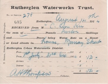
Financial record - Receipt, T. Drenen, 14/8/1914 (Exact)
It is believed that the C. Lim Kee who was paying these rates was Charles Lim Kee. According to the Rutherglen Sun September 11, 1896 he was starting a business known as the Cash Bakery in premises previously occupied by Conrad Huhs. In 1903 he moved to new premises next to the Bank of Victoria. By 1908 he had a shop and rooms in Main Street, and houses in Wallace Street and Murray Street. Part of a collection of business documents found under the floor of a building in Main Street when it was being renovated. At that time the owner was Don Chambers, and the premises was occupied as the Chambers Riteway Supermarket. The location (134 Main Street) is currently (2022) occupied by Miegel’s Pharmacy Rutherglen. Receipt from Rutherglen Waterworks Trust for water rates for a house in Murray Street. The form is printed on paper with hand written details reproduced with carbon paper.,"Rutherglen Waterworks Trust, No. of service 278. [receipt no.]: 605. Rutherglen, August 14th 1914. Received from Mr C. Lim Kee the sum of --- Pounds twelve Shillings and --- Pence, being Water Rate on a House or Land situate in house, Murray Street Rutherglen Urban Waterworks District. From 1st July to 31st Dec 1914." Signed A.H. Thompson, Collector.lim kee, rutherglen waterworks trust, water rates, business documents, 134 main street, chambers riteway supermarket -
 Kew Historical Society Inc
Map, MMBW, MMBW Town of Kew, 1910-21
The Melbourne and Metropolitan Board of Works (MMBW) was established by an act of the Victorian Parliament in 1890 to prepare for and to implement a sewerage and water reticulation system across what was then inner Melbourne, its surrounding and middle distance suburbs, including Kew. The MMBW was disbanded in 1991.The map collection of the Kew Historical Society has at its core the historic maps assembled and originally stored in the City Engineer's Department of the City of Kew. These include maps in a number of scales. The vast majority of maps were produced by the MMBW in the first two decades of the twentieth century, and are solid working maps, backed by linen for durability. These maps are historically significant to Kew, the City of Boroondara and to the history of the development of state utilities in Victoria. A number of the Kew maps have additional details added by former municipal officers, including the levels reached by various floods. As these were working documents, information was added to them long after the period of their initial production and distribution.Early map of the Town of Kew, created after 1910, at a scale 440 ft to 1 inch. The 'assembled' map by the City of Kew Engineer's Department includes scaled down copies of The Melbourne and Metropolitan Board of Works maps, Nos. 39, 40, 64, 65, 66, 67, 68, and 117. The map covers the entirety of the Town of Kew, bordered on its north and west by the River Yarra, by Burke Road in the East and Barkers Road in the south. The map shows the extent of urban development by that time, prominent institutions and the outlines of built structures in the municipality. TOWN OF KEW / SCALE 400 FEET TO 1 INCHmelbourne & metropolitan board of works, mmbw maps, mmbw plans, town of kew, cartography -
 Kew Historical Society Inc
Map, MMBW, MMBW Plan No.40 Collingwood & Kew, 1900-1910
The Melbourne and Metropolitan Board of Works (MMBW) was established by an act of the Victorian Parliament in 1890 to prepare for and to implement a sewerage and water reticulation system across what was then inner Melbourne, its surrounding and middle distance suburbs, including Kew. The MMBW was disbanded in 1991.The map collection of the Kew Historical Society has at its core the historic maps assembled and originally stored in the City Engineer's Department of the City of Kew. These include maps in a number of scales. The vast majority of maps were produced by the MMBW in the first two decades of the twentieth century, and are solid working maps, backed by linen for durability. These maps are historically significant to Kew, the City of Boroondara and to the history of the development of state utilities in Victoria. A number of the Kew maps have additional details added by former municipal officers, including the levels reached by various floods. As these were working documents, information was added to them long after the period of their initial production and distribution.Early map of part of the Borough of Kew, created in the first decade of the twentieth century, at a scale 160 ft to 1 inch. The map covers what was then the south western section of Kew, bordered on its north by Studley Park Road, in the west by Walmer Street and the River Yarra, by High Street South and Princess Street in the East and Barkers Road in the south. The map shows the extent of urban development by that time, prominent institutions and the outlines of built structures in the municipality. Contour lines and historic flood levels were added in ink to the map at a later stage.MELBOURNE AND METROPOLITAN BOARD OF WORKS / PLAN NO. 40 / COLLINGWOOD & KEWmelbourne & metropolitan board of works, mmbw maps, mmbw plans, borough of kew, cartography -
 Melbourne Tram Museum
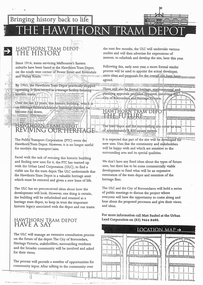
Document - Report, Minister of Transport, "Bringing history back to life - The Hawthorn Tram Depot", Aug. 1998
Report - consultation document titled - "Bringing history back to life - The Hawthorn Tram Depot", 7 A4 sheets, photocopied, outlining the joint Public Transport Corporation (PTC) and Urban Land Corporation (ULC) study into the future of the Hawthorn Tram Depot. Includes a site plan or location map, consultation proposals, news release from the Minister for Transport - Mr Robin Cooper - dated 12/8/1998 and background document providing details of some of the heritage trams - both the PTC and the TMSV. Two copies held - one stapled. Imaged as a pdf file.trams, tramways, hawthorn depot, heritage, minister for transport, tram depot -
 Kew Historical Society Inc
Photograph, J E & B L Rogers, Stables, 'Roseneath', Pakington Street, c.1959
This work forms part of the collection assembled by the historian Dorothy Rogers, that was donated to the Kew Historical Society by her son John Rogers in 2015. The manuscripts, photographs, maps, and documents were sourced by her from both family and local collections or produced as references for her print publications. Many were directly used by Rogers in writing ‘Lovely Old Homes of Kew’ (1961) and 'A History of Kew' (1973), or the numerous articles on local history that she produced for suburban newspapers. Most of the photographs in the collection include detailed annotations in her hand.The Rogers Collection provides a comprehensive insight into the working habits of a historian in the 1960s and 1970s. Together it forms the largest privately-donated collection within the archives of the Kew Historical Society.'Roseneath' was constructed in stages in the I850s by John Ambrose Kitchen, a soap-maker. In 1870 the brick house received an N.A.V. of £60 while in 1885 it was purchased by Edward John Dunn, a geologist. A new wing was built at the right side of the house and several rooms as well as the coach house, loft and groom's quarters were added. In 1903, during Dunn's ownership, the property was described as having eight roorns. The garden is recorded as having been designed by Baron von Mueller who was the Government Botanist from 1853. Source: City of Kew Urban Conservation Study, 1988"32"historic houses -- kew (vic.), roseneath -- pakington street -- kew (vic.) -
 Ballarat Tramway Museum
Document - TRB, Transport Regulation Board, "Enquiry into Public Passenger Transport Facilities - Geelong", Sept. 1953
Document for the "Enquiry into Public Passenger Transport Facilities - Geelong Urban District", held Sept - Oct 1953. Gives location, and dates, lists organisations represented, and statements of heads of the evidence in Chief by the various bodies, including Councils, SECV, ATOMEA, Trades and Labour, bus operators and other bodies. In the rear, has been inserted the AETA Submssion presented by Mr J Richardson. See also item 9876 for another version.Yields information about the 1953 TRB Enquiry into the closure of Geelong Tramways.Document - 55 foolscap sheets duplicated, plus one quarto sheet taped into the rear cover, with card covers, stapled and tape bound on the left hand side.tramways, trb, enquiries, enquiry, geelong, closure -
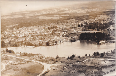
 The Beechworth Burke Museum
Photograph, Unknown
Aerial view of Lake Sambell, Beechworth with town views. Lake Sambell is a beautiful Victorian recreation lake and urban park with a unique history. It was created in the mid-1800s by the Rocky Mountain Mining company during the gold rush era and used as a mining site until the early 1900s, which brought Europeans into the area. It was turned into a reserve for residents in 1920 and is considered an icon of Beechworth as it represents the development of the community, human endeavour, and the spirit of the landscape.This photograph represents Lake Sambell with town views.Black and white reproduced rectangular photograph print on paper.Reverse: Stampbeechworth lake, lake sambell, aerial photo, construction, australian landscape, #beechworth, victoria -
 The Beechworth Burke Museum
Photograph, 1960
Taken in 1960, depicted is an aerial view of Lake Sambell and the surrounding township. Lake Sambell is a beautiful Victorian recreation lake and urban park with a unique history. It was created in the mid-1800s by the Rocky Mountain Mining company during the gold rush era and used as a mining site until the early 1900s, which brought Europeans into the area. It was turned into a reserve for residents in 1920 and is considered an icon of Beechworth as it represents the development of the community, human endeavour, and the spirit of the landscape.This photograph represents what Lake Sambell looked like in 1960.Black and white reproduced rectangular photograph print on paper.lake sambell, #beechworth, beechworth 1960s, lake, victoria, australian landscape, mining, rocky mountain mining company -
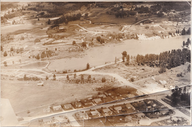 The Beechworth Burke Museum
Photograph, 1960
Taken in 1960, depicted is the construction of Lake Sambell, looking west across the lake. Lake Sambell is a beautiful Victorian recreation lake and urban park with a unique history. It was created in the mid-1800s by the Rocky Mountain Mining company during the gold rush era and used as a mining site until the early 1900s, which brought Europeans into the area. It was turned into a reserve for residents in 1920 and is considered an icon of Beechworth as it represents the development of the community, human endeavour, and the spirit of the landscape.This photograph represents additional construction to Lake Sambell as a recreational reserve.Black and white reproduced rectangular photograph print on paper.beechworth lake, lake, lake sambell, construction, #beechworth, australian landscape, beechworth 1960s, victoria -
 Eltham District Historical Society Inc
Photograph, Barak Bushlands Reserve, Eltham, March 2003, 2003
This area is urban and wetlands west of the Eltham gateway approach near the bridge over Diamond Creek and forms part of a walking trail. On 15 August 2004, the Shire of Nillumbik officially named the area "Barak Bushlands" as part of its commitment to Aboriginal reconciliation. The naming day memorialised the one hundred and first anniversary of the death of the last full-blood Yarra Aboriginal leader, William Barak. Source: Aboriginal reconcilation events in Nillumbik, Ken Eckersall, 2006.Digital scan from borrowed photobarak bushlands reserve, eltham, walking trail -
Kew Historical Society Inc
Flyer - 60 Pakington Street, Kew
Subdivision plans and real estate flyers/brochures reveal a number of aspects of urban development and history. The Kew Historical Society's collection of these plans, as well as advertisements extracted from magazines, cover key aspects of community development and architectural history of Kew and Kew Eat as well as surrounding suburbs. While most of the plans in the collection were gifted to the Society by the former City of Kew, a number of other plans and advertisements have been donated by individuals, of which this is an example. Single page illustrated flyer, advertising 60 Pakington Street, Kew for sale. Annotation in pen and ink at right.neville collection, 60 pakington street -- kew (vic.), real estate advertisements -- kew (vic.)