Showing 3710 items matching " beach"
-
 Mission to Seafarers Victoria
Photograph - Photograph, Black and white, circa 1960s
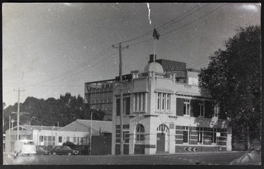
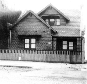
The Geelong Rest located at 3 Moorabool Street was created in 1895. The building depicted in the photograph ( taken from the Western Beach Road) is known as the King Edward VII Sailors' Rest building; it was designed by architect Percy Everett and replaced the older building in 1912. In 1901, it became the Geelong branch of the Mission to Seamen. The building is still standing on the waterfront in Geelong and has a commercial use.Medium b & w photograph depicting the front facade of the Sailors' Rest in Geelong.geelong, sailors' rest, seafarer, king edward vii sailors' rest building, 1912, percy everett, kombi -
 Phillip Island and District Historical Society Inc.
Photograph, Early 20th Century
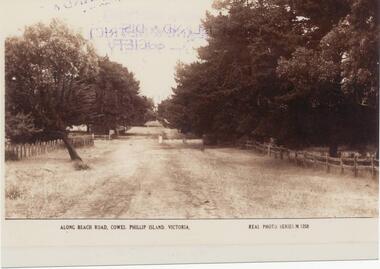
One of 20 photographs/postcards donated by Mary KarneySepia photograph copy of a postcard. Beach Road, Cowes with fences and trees lining the road."Along Beach Road, Cowes, Phillip Island, Victoria." "Real Photo Series M 1258"beach road, cowes phillip island, cowes phillip island, mary karney -
 Lakes Entrance Historical Society
Photograph - Footbridge, 1937c
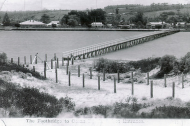
Two other copies 6.5 x 9 imageBlack and white photograph showing waterfront, Esplanade, some buildings and background hill almost completed footbridge across Cunninghame Arm. Posts defining pathway over sand dune to ocean beach. Lakes Entrance VictoriaFootbridge to Ocean Beach, Lakes Entrancewaterways, bridges, township -
 Phillip Island and District Historical Society Inc.
Photograph, ?
Part of collection of Photographs donated to the Museum by Family of the late Mr. Jack Jenner. (1977).Black & White Postcard - Real Photo Series. View of beach & old baths, west of Jetty, Cowes.A charming Spot on The Beach, Cowes, Phillip Island. Real Photo Series No. M.1252local history, photography, photographs, slides, film, view cowes, black & white photograph, jack jenner, beach cowes, real photo series -
 Port Fairy Historical Society Museum and Archives
Photograph
East beach near Battery HillColoured photograph of Empty beach with scrub and picket fence in foregroundeast beach, battery hill, ocean, sea, dune, tea tree, tree -
 Port Fairy Historical Society Museum and Archives
Photograph
South Beach DevelopmentColoured photograph of Hills above South Beach Estate looking to seasouth beach, development, west, farmland -
Glenelg Shire Council Cultural Collection
Photograph - Photograph - Photographed print of a re-photographed photograph Nuns Beach, c. 1970
Photographic print of a rephotographed photograph. Image shows Nuns Beach. Photo taken on sand looking north to Whalers Bluff. 3 small wooden buildings built against cliffs. Hull of large boat on blocks on sand against cliff.Front: 'Nuns Beach' - green inck -
 Port Fairy Historical Society Museum and Archives
Photograph - Photocopy
East beach looking northColoured photograph of East Beach with summer crowd and life savers flagseast beach, marram grass, crowd, people, bathers -
 City of Kingston
Photograph - Digital image, Colour, City of Kingston (Graham Whitehead)
Colour image of Mentone foreshore looking towards Mordialloc. The natural environment of Kingston significantly impacted its development. The bay was a source of food and income, as well as a holiday destination. Colour image of Mentone beach looking towards Mordialloc, with Mentone life saving club in distance.mentone, beach, environment -
Glenelg Shire Council Cultural Collection
Photograph - Photograph - Portland Centenary Celebrations 1934, 19/11/1934
Black and white photo. Slab hut built on Henty Beach, Portland, as part of Centenary celebrations 19 November. 1934. Man in suit standing beside hut.Back: 'Hut built on beach for Centenary 1934' - handwritten in pencilportland centenary celebrations 1934 -
 Port Fairy Historical Society Museum and Archives
Photograph
South Beach DevelopementColoured photograph of Land works near South Beach with earth moving equipmentsouth beach, development -
 Port Fairy Historical Society Museum and Archives
Photograph
South Beach Development Coloured photograph of Earthworks in foreground with some housing on the South beach estate in backgroundsouth beach, development, houses, road making -
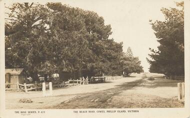 Phillip Island and District Historical Society Inc.
Photograph - Post Card, Early 1900's
One of 17 photographs donated by Olive BlameySepia postcard of the Beach Road with fence and trees on the left and trees on the right."The Rose Series, P. 674" "The Beach Road, Cowes, Phillip Island, Victoria" Letter on back to Lois from Auntie Alicebeach road, cowes phillip island, phillip island, olive blamey -
 Port Fairy Historical Society Museum and Archives
Photograph
East beach near battery hill sails of a tall ship in distance Coloured photograph of the East Beach with the lighthouse and a tall ship in the backgroundeast beach, ship, ocean, sea -
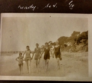 Phillip Island and District Historical Society Inc.
Photograph, Ready, set, go, 1925-1926
Cowes beachSepia photograph of four women and one girl dressed in bathers on beach with pier in background.Ready set gophotographs, cowes beach, bathers near the pier, social life and customs -
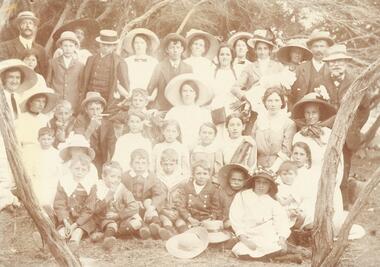 Ringwood and District Historical Society
Photograph, North Ringwood & South Warrandyte residents beach picnic c1905
Image O0054b has list of namesSmaller photograph with numbers and identification attached reads as follows: "North Ringwood & South Warrandyte residents beach picnic c1905. Photo from M. zoch, Hardings Rd. South Warrandyte. 1. Mr. Daniels, 2. Marion Coleman, 3. V. Zoch, 4. Mrs. Daniels, 5. Len Milne, 6. Miss D. Coleman, 7. Mic Johansen, 8. Mrs. Johansen, 9. Miss A. Sloan, 10. Mrs. Hussey, 11. Mrs. B. Milne, 12. Mrs. Tortice, 13. Bert Milne, 14. P. Coleman, 15. Miss J. Tortice, 16. Miss S. Tortice, 17 May Tortice, 18. Mrs. J. Coleman, 19. Claude Milne, 20. Rosie Johansen, 21, M. Zoch, 22 Harold Milne, 23. Miss O. Johansen, 24. Miss F. Sloan, 25. Eileen Mitchell, 26. Amy Johansen, 27. Roy Milne, 28. Stan Milne, 29. Dave Coleman, 30. Bell Mitchell, 31. Reg Danields, 32. Vicki Tortice, 33. Harry Tortice, 34. Millie Mitchell, 35. Florrie Tortice, 36. Bill Tortice, 37 Emily Tortice". -
 Port Melbourne Historical & Preservation Society
Photograph - Irvine, 42 Beach Street, Port Melbourne, 1950
42 Beach St was the home of Jan McDonald's family, adjacent to the Pier HotelVarious photographs of 'Irvine' at 42 Beach Street, c. 1950built environment - domestic, janice c morton macdonald -
 Chelsea & District Historical Society Inc
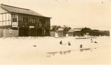
Photograph - Edithvale Life-Saving Club, Clubhouse, 1920's - 1930's
Edithvale Life Saving Club was founded in 1919.Sepia postcard of Edithvale Life-Saving Club, a double story wooden building, built on the foreshore of Edithvale beach. Bathing boxes are on the right hand side, with boats sitting on the sand and three children playing, while a man watches.Kiosk and beach, Edithvale Valentine series no 198life saving club, edithvale, edithvale beach, bathing boxes -
 Port Fairy Historical Society Museum and Archives
Photograph, Jock Varcoe
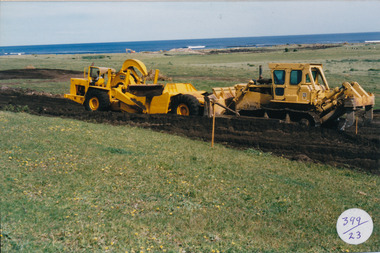
South Beach DevelopmentColoured photograph of Earth moving equipment cutting a road through South Beach Estatesouth beach, development, road making, equipment, street -
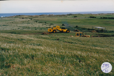
 Port Fairy Historical Society Museum and Archives
Photograph, Jock Varcoe
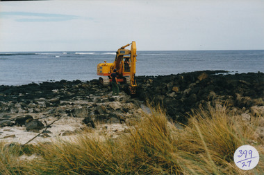
South Beach DevelopementColoured photograph of Mechanical digger working on rocks digging a drain for South Beach Estatesouth beach, development, digger, bluestone -
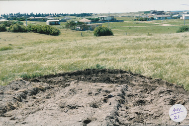
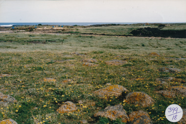
 Port Fairy Historical Society Museum and Archives
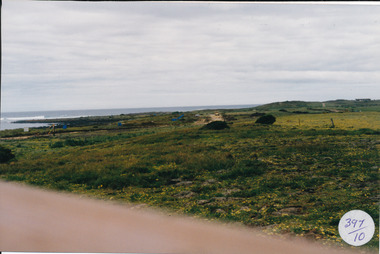
Photograph
South Beach Development Coloured photograph of South beach estate, blue marks are tree plantings along track397/10 (since removed 2021)south beach, development, road, road making, estate -
 Lakes Entrance Historical Society
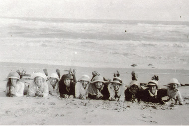
Photograph - Harbeck Family, 1933
Black and white photograph of nine young women including Harbeck girls and an infant lying on the beach all fully clothed, wearing sunhats, resting on their forearms and looking straight at camera. Lakes Entrance VictoriaLakes Entrance Beach Belles c1933 on back of originalgenealogy, recreation -
 Phillip Island and District Historical Society Inc.
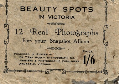
Postcard, Beauty spots in Victoria
Tourist photographs of Phillip IslandHistoricalSmall black and white photos of scenes of Phillip Island including the jetty, beach, Nobbies and ferries. Enclosed in a beige paper envelope.Beauty spots in Victoria. 12 Real Photographs for your Snapshot Album. Produced in Australia by The Rose Stereograph Co. Price 1/6 1. The Pier, Cowes, 2. Front beach, Cowes, 3. Alvina & Genista at pier, $. Koala in tree, 5. beach near Nobbies, 6. The Nobbies, 7. The Pinnacles, 8. Looking out at Forest caves, 9. Lovers Walk - Cowes, 10. Forest Cave, 11. The road to back beach, 12. The beach & pier, Cowes.the nobbies, ferries, cowes jetty, forrest caves, phillip island, black & white postcard copy, photographs -
 Lakes Entrance Historical Society
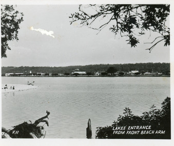
Postcard, 1945c
Black and white small format postcard showing a distant view of the town, taken from the southern shore of the lake. The view shows a glimpse of the beach known formerly as Play Point, the picture framed by native vegetation. Lakes Entrance VictoriaLakes Entrance from front beach armtownship, waterfront -
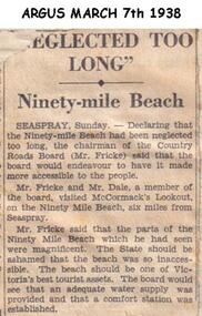 Phillip Island and District Historical Society Inc.
Newspaper clippings, 07/03/1938
Article in which Chairman of Country Roads Board (Mr Fricke) declared that the Ninety Mile Beach had been neglected and should be a Tourist asset. The Board would arrange water supply and Comfort Station.Article about Ninety Mile Beach.local history, documents, newspapers, ninety mile beach, black & white newspaper clipping -
Port Melbourne Historical & Preservation Society
Document, City of Port Phillip, Naming Proposal Port Melbourne, Mar 2002
Proposal for "Fussy"s Beach"in honour of Peter Fussell, formerly South Melbourne engineer, soundly rejected. 1. Although Peter was involved in designs for this area of foreshore as an engineer for COPP, he was unknown in Port 2. Not customary to name beaches after people 3. "Fussy" was only certain officer's nickname for Peter and was also seen to lack dignityPublic notice placed in Emerald Hill Times, March 2002, proposing "Sandridge Beach" be renamed "Fussy's Beach"in honour of former city engineer peter Fussell, who was ill.town planning - proposals shelved, garden city, peter fussel - city engineer -
 Queenscliffe Maritime Museum
Photograph - JAMES WILLIAM stranded Pt Lonsdale, JAMES WILLIAM beached at Point Lonsdale, 1953
JAMES WILLIAM fishing boat beachedstranded JAMES WILLIAMBlack & white photo of the fishing boat JAMES WILLIAM stranded & beached at Point Lonsdale Reverse - " The JAMES WILLIAM stranded approx 1/2 mile west of the Pt Lonsdale lighthouse / owner James 'Dugga' Warren, crewman C Zanoni / For date - see L Ferrier / salvaged by jacking up, putting cradle under, 300-400 people pulled her up under dunes, on planking tracks and rollers / 3 weeks later used the same procedure to launch her into sea. "historical references, fishing boat, stranded & beached, james william -
 Port Fairy Historical Society Museum and Archives
Photograph
East beach car park and sandColoured photograph of Expanse of East Beach from the car park people playing on sandeast beach, car park, sandcastle, caras, dune -
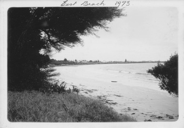 Port Fairy Historical Society Museum and Archives
Photograph
East Beach 1973Black and white photograph of East Beach with she oaks on the left and Norfolk Island pine in distanceNovember 1973 kodakeast beach, battery hill, ocean, sea, sand -
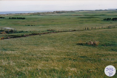
 Port Fairy Historical Society Museum and Archives
Photograph
South Beach DevelopmentColoured photograph of Looking from hill above South Beach Estate before earth workssouth beach, development, south west, bluestone, road, street