Showing 1406 items
matching bushfire
-
 Marysville & District Historical Society
Photograph (Item) - Colour photograph, Unknown
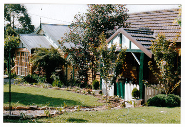
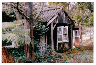
A colour photograph of the front facade and garden of Arbor Green Galleries in Marysville. This cottage, along with most of the buildings in the township, was destroyed in the 2009 Black Saturday bushfires.A colour photograph of the front facade and garden of Arbor Green Galleries in Marysville.1 Falls Rd M'sville./ Arbor Green Galleries & Cottage.marysville, victoria, australia, photograph, accommodation, arbor green cottage, 2009 black saturday bushfires -
 Marysville & District Historical Society
Photograph (Item) - Colour photograph, 1992
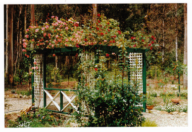
A colour photograph of the front pergola at the entrance to Arbor Green Galleries in Marysville. This cottage, along with most of the buildings in the township, was destroyed in the 2009 Black Saturday bushfires.A colour photograph of the front pergola at the entrance to Arbor Green Galleries in Marysville.1 Falls Rd M'sville./ Arbor Green Galleries & Cottage.marysville, victoria, australia, photograph, accommodation, arbor green cottage, 2009 black saturday bushfires -
 Marysville & District Historical Society
Photograph (Item) - Colour photograph, Unknown
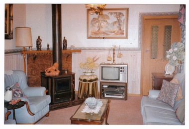
A colour photograph of the sitting room in the cottage at Arbor Green Galleries and Cottage. This cottage, along with most of the buildings in the township, was destroyed in the 2009 Black Saturday bushfires.A colour photograph of the sitting room in the cottage at Arbor Green Galleries and Cottage.1 Falls Rd. M'sville./ Cottage Sitting Room.marysville, victoria, australia, photograph, accommodation, arbor green cottage, 2009 black saturday bushfires -
 Eltham District Historical Society Inc
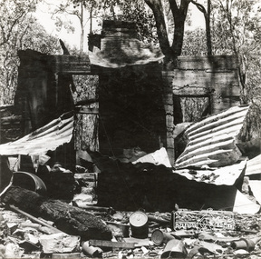
Photograph, George W. Bell, 'Windy' Gale's burnt out home, Wild Dog Creek Road, Jan. 1962, Jan 1962
Building of Pensioners Cottages at St Andrews; for those burnt out in the 1962 bushfires. A voluntary scheme of Mavis Gill through the Kangaroo Ground Relief CommitteeBlack and white photo mounted on card'Windy' Gale's burnt out home, Wild Dog Creek Road Photo Geo. W. Bell, Jan. 1962victorian bushfires - 1962, bushfires, dick (windy) gale, fire damage - buildings, george w bell, houses, st andrews, wild dog creek road, mavis gill, pensioners cottages -
 Eltham District Historical Society Inc
Photograph, George W. Bell, Mavis Gill making a turn near 'Windy' Gale's home, Wild Dog Creek Road, Jan. 1962, Jan 1962
Building of Pensioners Cottages at St Andrews; for those burnt out in the 1962 bushfires. A voluntary scheme of Mavis Gill through the Kangaroo Ground Relief CommitteeBlack and white photo mounted on cardMavis Gill making a turn near 'Windy' Gale's place Wild Dog Creek area Photo Geo. W. Bell, Jan. 1962victorian bushfires - 1962, bushfires, dick (windy) gale, fire damage - buildings, george w bell, houses, st andrews, wild dog creek road, mavis gill, pensioners cottages -
 Marysville & District Historical Society
Photograph (Item) - Colour photograph, Unknown
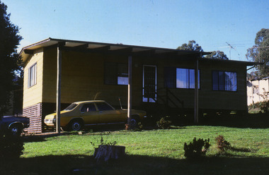
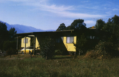
A colour photograph of one of the cottages at Amber View Cottages in Marysville. These cottages, along with most of the buildings in the township, were destroyed in the 2009 Black Saturday bushfires.A colour photograph of one of the cottages at Amber View Cottages in Marysville.amber view cottages, marysville, victoria, australia, accommodation, photograph, 2009 black saturday bushfires -
 Marysville & District Historical Society
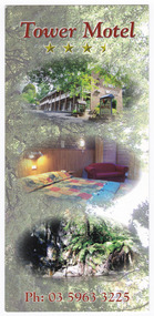
Flyer (item) - Accommodation flyer, Tower Motel, Unknown
An information flyer regarding the accommodation and facilities at the Tower Motel in Marysville. The Tower Motel was one of the few buildings in Marysville to survive the 2009 Black Saturday bushfires.An information flyer regarding the accommodation and facilities at the Tower Motel in Marysville.marysville, victoria, australia, tower motel, accommodation, 2009 black saturday bushfires, flyer -
 Marysville & District Historical Society
Flyer (item) - Accommodation flyer, Tower Motel, Unknown
An information flyer regarding the accommodation and facilities at the Tower Motel in Marysville. The Tower Motel was one of the few buildings in Marysville that survived the 2009 Black Saturday bushfires.An information flyer regarding the accommodation and facilities at the Tower Motel in Marysville.marysville, victoria, australia, tower motel, accommodation, flyer, 2009 black saturday bushfires -
 Marysville & District Historical Society
Photograph (Item) - Colour photograph, Unknown
A colour photograph of one of the cottages at Amber View Cottages in Marysville. These cottages, along with most of the buildings within the township, were destroyed in the 2009 Black Saturday bushfires.A colour photograph of one of the cottages at Amber View Cottages in Marysville.amber view cottages, marysville, victoria, australia, accommodation, photograph, 2009 black saturday bushfires -
 Marysville & District Historical Society
Photograph (Item) - Colour photograph, 1986
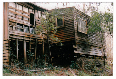
A colour photograph of the timber worker's cottage that became Arbor Green Cottage in Marysville. This cottage, along with most of the buildings in the township, was destroyed in the 2009 Black Saturday bushfires.A colour photograph of the timber worker's cottage that became Arbor Green Cottage in Marysville.1 Falls Rd M'sville Spring 1986./ Rear cottage./ To become/ Arbor Green Cottage.marysville, victoria, australia, photograph, accommodation, arbor green cottage, 2009 black saturday bushfires -
 Marysville & District Historical Society
Photograph (Item) - Colour photograph, 1986
A colour photograph of the timber worker's cottage that became Arbor Green Cottage in Marysville. This cottage, along with most of the buildings in the township, was destroyed in the 2009 Black Saturday bushfires.A colour photograph of the timber worker's cottage that became Arbor Green Cottage in Marysville.1 Falls Rd M'sville./ Timber workers cottage/ To become Arbor Green Cottage./ Spring 1986.marysville, victoria, australia, photograph, accommodation, arbor green cottage, 2009 black saturday bushfires -
 Marysville & District Historical Society
Photograph (Item) - Colour photograph, Unknown
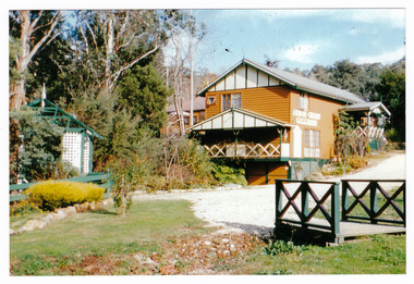
A colour photograph of the main building and entrance gate to Arbor Green Galleries in Marysville. This cottage, along with most of the buildings in the township, was destroyed in the 2009 Black Saturday bushfires.A colour photograph of the main building and entrance gate to Arbor Green Galleries in Marysville.Arbor Green Galleries./ 1 Falls Rd M'sville./ Side approach.marysville, victoria, australia, photograph, accommodation, arbor green cottage, 2009 black saturday bushfires -
 Marysville & District Historical Society
Photograph (Item) - Colour photograph, Unknown
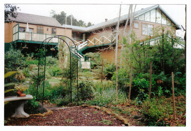
A colour photograph of the rear of the main building and garden at Arbor Green Galleries in Marysville. This cottage, along with most of the buildings in the township, was destroyed in the 2009 Black Saturday bushfires.A colour photograph of the rear of the main building and garden at Arbor Green Galleries in Marysville.Arbor Green Galleries./ 1 Falls Rd M'sville./ Rear aspectmarysville, victoria, australia, photograph, accommodation, arbor green cottage, 2009 black saturday bushfires -
 Eltham District Historical Society Inc
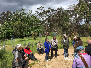
Photograph, Peter Pidgeon, Killeavey, Laughing Waters Road, Eltham 5 Nov 2016, 5 Nov 2016
The Wurundjeri ceremonial circle at Killeavey which has been constructed on the site of the original homestead which was destroyed in the 1839 bushfires. Heriitage Excursion - Kileavey Walk and TalkBorn Digitalactivities, eltham district historical society, heritage excursion, kileavey, parks victoria, laughing waters road, eltham, wurundjeri -
 Marysville & District Historical Society
Photograph (Item) - Colour photograph, 1986
A colour photograph of the timber worker's cottage that became Arbor Green Cottage in Marysville. This cottage, along with most of the buildings in the township, was destroyed in the 2009 Black Saturday bushfires.A colour photograph of the timber worker's cottage that became Arbor Green Cottage in Marysville.1 Falls Rd M'sville./ Spring 1986./ Timber workers cottage/ To bcome Arbor Green Cottagemarysville, victoria, australia, photograph, accommodation, arbor green cottage, 2009 black saturday bushfires -
 Whitehorse Historical Society Inc.
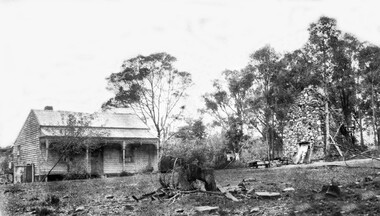
Photograph, Schwerkolt Property 3rd house with Smokehouse, 1917 - 1927
The third ,weatherboard, house was built after the first house was burnt down in the 1905 bushfires. After the property was sold to developers in 1959 this house was burnt down by vandals.Black and white photo of the weatherboard house with verandah on the left of the photo and the stone smokehouse on the right.whalen, rosalie, schwerkolt, arthur, schwerkolt 3rd home -
 Marysville & District Historical Society
Flyer (item) - Accommodation flyer, The Tower MARYSVILLE, Unknown
An information flyer regarding the accommodation and facilities available at The Tower Motel in Marysville. The Tower Motel was one of the few buildings in Marysville that survived the 2009 Black Saturday bushfires.An information flyer regarding the accommodation and facilities available at The Tower Motel in Marysville.marysville, victoria, australia, tower motel, accommodation, flyer, 2009 black saturday bushfires -
 Marysville & District Historical Society
Flyer (item) - Accommodation flyer, Tower Motel, Unknown
An information flyer regarding the accommodation and facilities available at the Tower Motel in Marysville. The Tower Motel was one of the few buildings in Marysville that survived the 2009 Black Saturday bushfires.An information flyer regarding the accommodation and facilities available at the Tower Motel in Marysville.marysville, victoria, australia, tower motel, accommodation, flyer, 2009 black saturday bushfires -
 Marysville & District Historical Society
Flyer (item) - Accommodation flyer, Tower Motel, Unknown
An information flyer regarding the accommodation and facilities available at The Tower Motel in Marysville. The Tower Motel was one of the few buildings in Marysville that survived the 2009 Black Saturday bushfires.An information flyer regarding the accommodation and facilities available at The Tower Motel in Marysville.marysville, victoria, australia, tower motel, accommodation, flyer, 2009 black saturday bushfires -
 Marysville & District Historical Society
Flyer (item) - Accommodation flyer, Tower Motel, Unknown
An information flyer regarding the accommodation and facilities available at The Tower Motel in Marysville. The Tower Motel was one of the few buildings in Marysville that survived the 2009 Black Saturday bushfires.An information flyer regarding the accommodation and facilities available at The Tower Motel in Marysville.marysville, victoria, australia, tower motel, accommodation, flyer, 2009 black saturday bushfires -
 Eltham District Historical Society Inc
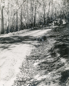
Negative - Photograph, J.A. McDonald, One Tree Hill Road Bridge, Christmas Hills, 2 July 1962
One Tree Hill Road Looking south 2/7/62 The bridge was destroyed by bushfires 15-16 January 1962. A temporary bridge was set up to the east sideRecord of various Shire of Eltham infrastructure works undertaken during the period of 1952-1962 involving bridge and road reconstruction projects, sometimes with Eltham Shire Council Project Reference numbers quoted. It was during this period that a number of significant improvements were made to roads and new bridges constructed within the shire that remain in place as of present day (2022). In many situations, the photos provide a tangible visible record of infrastructure that existed throughout the early days of the Shire. The album was put together by or under the direction of the Shire Engineer, J.A. McDonald.1962-07-02, bridge construction, christmas hills, infrastructure, shire of eltham, victorian bushfires - 1962, bush fires, one tree hill road, property damage -
 Eltham District Historical Society Inc
Photograph, Barry Philp, Eltham Barrel, c.1969
View looking from inside the fence below Research Oval. Believed to have been taken shortly after the 1968-69 Bushfire. The Eltham Barrel weas completed in 1968.research (vic.), eltham barrel, research oval -
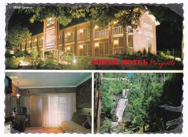 Marysville & District Historical Society
Postcard (item) - Colour postcard, Nucolorvue Productions Pty. Ltd, TOWER MOTEL Marysville, Unknown
A colour postcard from the Tower Motel in Marysville. The postcard was published by Nucolorvue as a souvenir of Marysville. The Tower Motel was one of the few buildings in Marysville that survived the 2009 Black Saturday bushfires.A colour postcard from the Tower Motel in Marysville. The postcard was published by Nucolorvue as a souvenir of Marysville.A/ NU-COLOR-VUE/ OF/ AUSTRALIA PLACE/ STAMP/ HERE POST CARD Product of Australia RP66 NUCOLORVUE PRODUCTIONS PTY. LTD./ COPYRIGHT TOWER MOTEL/ Murchison St., Marysville, Vic./ Phone (059) 63 3225 New luxury Motel, 100 km north/ east of Melbourne in the heart of/ the big timber country - just a/ short drive from the magnificent/ floodlit Steavenson's Falls - the/ tallest in Victoria. Units equipped with all modern/ facilities, including colour T.V. and/ air conditioning.marysville, victoria, australia, tower motel, accommodation, postcard, souvenir, nucolorvue productions pty. ltd., 2009 black saturday bushfires -
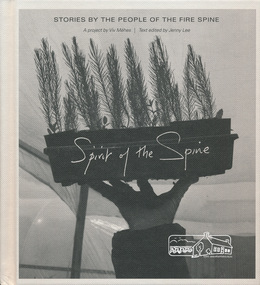 Eltham District Historical Society Inc
Book, Spirit of the spine: stories by the people of the fire spine, 2013
Stories of courage, inspiration and healing in the wake of the North East Victorian bush fires. Photographer Viv Mehés spent more than 3 years taking photographs and talking with local people about the 2009 firestorm and its legacy. Includes first-hand experiences of people affected by these fires — the stories here are their stories. - https://www.blacksaturdaymuseum.com/SpiritOfTheSpine.htm Includes map of area covered. black saturday, bushfire, victorian bushfires - 2009, viv mehes -
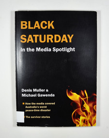 Marysville & District Historical Society
Book, Denis Muller et al, Black Saturday-In the Media Spotlight, 2011
How the media covered Australia's worst peace-time disaster and the survivors' storiesBlack front cover. Photograph of flames on the lower right hand corner of the front cover. Back cover has the blurb about the book.non-fictionHow the media covered Australia's worst peace-time disaster and the survivors' storiesblack saturday, media coverage, survivors, bushfire -
 Eltham District Historical Society Inc
Photograph, Fred Mitchell, Regrowth timber at Yan Yean Reservoir, 1968, 1968
Digital copy of colour photographfred mitchell collection, 1968, bushfire, yan yean reservoir -
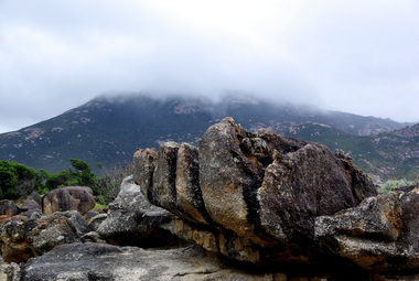 Ballarat Heritage Services
Digital photograph Wilsons Promontory after fire, Wilsons Promontory after fire, early 2000s
Digital photographswilsons promontory, fire, bushfire, tidal river