Showing 1370 items
matching centre 5
-
 Eltham District Historical Society Inc
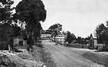
Negative - Photograph, Tom Prior, Main Road near Eltham Railway Station, c.1910
View looking south along Main Road, Eltham from near present day Luck Street. On the immediate right is a fence with the words “Hot Water” painted on it followed by William J Capewell’s butcher shop, then the slaughter yard and saleyards with the entrance access to the railway station. Contained within the saleyards facing the street, a small shelter with the name H.H. Clark upon it. Horace Harold Clark was the son of Eltham State School’s first Head Teacher, David George Clark. As well as being a farmer, he was an Estate Agent and conducted auction sales, presumably from this shelter. The large weatherboard building on the corner (opposite present-day Arthur Street) with signs for Summer Drinks and Hot Water painted on the side is Luther and Ada Haley’s General Store and Bakery, built 1902. This was the first building in what is now Eltham’s present shopping town centre. Haley previously ran the General Store and Bakery on the corner of Main Road and York Street until his lease expired and the premises were bought by Mrs Sarah Burgoyne in 1902. The store later was known as Staff's Store. In the distance approximately mid-way between the Butcher shop and the Bakery are the tops of what appears to be two cypress trees, which could well be the trees in front of the Shillinglaw Cottage facing Main Road. On the eastern (left) side of Main Street is Haley’s Paddock, which was used on occasions for community picnics. Capable of holding 10,000 people, with ample shade and hilly surroundings it was an ideal place for any community gathering such as the State Schools’ Picnic in 1904. Picture dated as c.1910 based on similar picture published in the Weekly Times, Feb. 1912. Kerb and channelling added 1923. Cross Ref: 610 (looking north), 611 (later stage), 613. Same as 705 (though in better condition)This photo forms part of a collection of photographs gathered by the Shire of Eltham for their centenary project book,"Pioneers and Painters: 100 years of the Shire of Eltham" by Alan Marshall (1971). The collection of over 500 images is held in partnership between Eltham District Historical Society and Yarra Plenty Regional Library (Eltham Library) and is now formally known as the 'The Shire of Eltham Pioneers Photograph Collection.' It is significant in being the first community sourced collection representing the places and people of the Shire's first one hundred years.Digital image 4 x 5 inch B&W Neg 120 format B&W negative (spare)shire of eltham pioneers photograph collection, eltham, main road, butcher, eltham railway station, railway station, w.j. capewell, baker, eltham town centre, general store, luther haley, reynolds prior collection, shops, haley's paddock, hot water, m.m. clark, sign, summer drinks, eltham sale yards, eltham slaughter yard, staffs general store -
 Orbost & District Historical Society
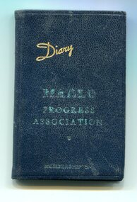
Document - diary, 1946
The association was formed as a means of giving Marlo residents a voice with the then Orbost Shire Council. It has continued as the Marlo Ratepayers & Residents association.This is associated with the history of Marlo which is a small town which has a close association with Orbost. Marlo sits at the mouth of the Snowy River and was the port for Orbost. It came under the Orbost Shire Council. A small dark blue covered diary with "Diary" in gold print written diagonally across the top and in the centre "MARLO PROGRESS ASSOCIATION" in light green print with "MEMBERSHIP 5/-" in light green print underneath. It is unused.marlo, east gippsland, coastal communities, orbost shire council, progress association, memberships -
 Orbost & District Historical Society
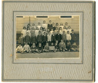
black and white photograph, Wilson, Les G, 1919
The 19th of March 1886 proved an important day in the lives of many early settlers in the Orbost area, because on this day the Orbost State School opened. The fact that the school had first operated temporarily in a leased building, and on a half-time basis with SS2745 Jarrahmond, did not dampen the enthusiasm of the local inhabitants as they saw their offspring commence their education under the guidance of HT Campbell Mackay. However he remained in charge only until 12th of May 1886. The second HT, John Rowe, served until 1908. On 30th of June 1887, a portable room was provided; it being brought to the area by schooner. The school now had accommodation for 30 pupils; the teacher's welfare was considered because quarters of two rooms were attached. As the population increased so did the needs of the school. This was reflected in the provision of a larger classroom in 1898. During 1910-11 the first approaches were made to the Department for the establishment of a HES in Orbost and this became a reality in 1912. Orbost HES supplied post-primary education in the district until a high school was built in 1948. When fire destroyed the school in 1941 local halls were used as classrooms until a new school was built. Work was quite rapid and a new brick structure was opened by the Hon. A. E. Lind, MLA, on 13th of February 1942. This new building was a fine type of school of which both the pupils and the HT Leslie Collins were indeed proud. But Orbost continued to develop and the new school was soon overtaxed. This resulted in the erection of two Bristol classrooms in 1947. By 1950, when the school population had reached 500 pupils the opening of the new school at Orbost North was welcomed by all concerned. In 1963 the Department purchased land diagonally opposite the school and developed it as a playing area. In 1965 two LTCs were opened in November, and in October 1968 the Brodribb School building was moved to SS2744 Orbost for use as a general purpose room. (info. Schools east Gippsland) This item is associated with the history of education in Orbost.A black / white photograph on a grey buff cardboard frame. It is of students outside the Orbost State School. A child in the centre bottom row is holding a sign reading " Grades 5 & 6".on back - "Mary Gilbert"education-orbost orbost-state-school -
 Ringwood and District Historical Society
Badges, Badges and Coins 1939-45: 50 years of Queen Victoria's Reign; ANZAC Pins, King George and Queen Elizabeth; City of Wangaratta; etc, 1939 - 1945
Many issues - ANZAC DayBadges and coins. Refer photograph. +Additional Keywords: Pratt, G / GibbonTop Row L_R:; Victoria - 50 Years of Reign. Diam 3cm.; RDFA/Time Keeper (2 badges); Plastic 7-pointed badge (2 badges): Palestine-Gallipoli, FRANCE, Egypt, Mesopotamia, North Sea, New Guinea. In Centre: Lest We Forget printed across a map of Australia.; Assorted ANZAC pins/badges (5 badges); Middle Row L-R:; Side 1: King George VI & Queen Elizabeth (5 badges); Side 2: City of Wangaratta. Wangaratta Proclaimed a City.; Bottom Row:; Royal Life Saving Society, Established 1891. Centre: Awarded to G. Gibbon 1945.; Awarded to G Pratt v 1945; Victorian Rifle Association (2 badges); Legacy Badges/Pins (2 badges); Map of Australia on metal pin; Badge: Side 1 Centenary of Victoria 1934. On undeveloped scene embossed)/ Side 2 Centenary of Victoria 1935. (On city skyline embossed) Diam 2.6 cm.; Pavilion Fund Bayswater 1947-1948 -
 Ringwood and District Historical Society
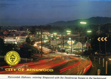
Postcards, Colorscans (Publishing) Pty Ltd, Various postcards of Ringwood in the 1970s, c. 1968
... ); 5. The Civic Centre (3303_005.jpg); 6. The Ringwood Lake... Tower (3303_004.jpg); 5. The Civic Centre (3303_005.jpg); 6 ...Postcards - pack of 6: 'Ringwood Victoria - tear off postcard folder - 6 views' (two identical folders); 1. Maroondah Highway, entering Ringwood with the Dandenong Ranges in the background (3303_001.jpg); 2. Aerial View of the City of Ringwood (3303_002.jpg); 3. Eastland Regional Shopping Centre at dusk (3303_003.jpg); 4. The Ringwood Memorial Clock Tower (3303_004.jpg); 5. The Civic Centre (3303_005.jpg); 6. The Ringwood Lake (3303_006.jpg) -
Ringwood and District Historical Society
Magazine, Property Publications, Eastland article in Property magazine, 1961
... on page 5 headed "Regional Centre For Eastland" about the proposed... 1961 including article on page 5 headed "Regional Centre ...Property magazine for Oct/Dec 1961 including article on page 5 headed "Regional Centre For Eastland" about the proposed 2 million pound development due to be completed in 1964. +Additional Keywords: Eastland -
Ringwood and District Historical Society
Eisteddfod, Sponsored by Ringwood City Council, Programme for 50th Annual Ringwood Eisteddfod 2004, at Senior Citizens Centre, 2004
Programme covering 50th Annual Ringwood Eisteddfod 18/6/2004-5/7/2004 held at Senior Citizens, Ringwood. 3 page booklet. +Additional Keywords: Hawkins, Ruth -
Ringwood and District Historical Society
Equipment - Printers blocks, Set of 7 Printers blocks showing early Ringwood Buildings 1927-1960, 1927 -1960
Set of 7 printers blocks showing early Ringwood buildings between 1927 and 1960. Town Hall, Old Mechanics Institute and Ringwood East Welfare Centre +Additional Keywords: McGaskill, J.K. / Bamford Bros. / Wilmot Dr.1 Ringwood Town Hall 2 Aug 1927 2. Laying Foundation Stone of the Auditorium of the Town Hall by Mayor J.K. mcGaskill. See Mail 22 Dec 1949 for names. 3. and 4. Souvenir supplement 17 March1960 Antimony Mine 5. Souvenir supplement 17 March 1960 Bamford Brothers 6.Old Mechanics Institute. Built 1910. This picture taken Nov 1926 7. Opening of the Welfare Centre Ringwood East 3 Nov 1960 . Dr. Wilmot -
 Ringwood and District Historical Society
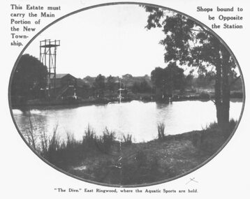
Photograph, "The Dive" East Ringwood, Knaith Road. (1924/5)
Black and white photograph. See also VC 2975 (Images RE 0026 and RE 0028) Typed directly below photograph, "'The Dive' East Ringwood, where the Aquatic Sports are held". Typed on mounting sheet below photograph, "'The Dive' East Ringwood, Knaith Rd. where the aquatic sports were held was a clayhole from a brickworks. Note diving tower. Building to left was part of the brickworks complex. Later the site of the East Ringwood Community Centre". One copy marked 1924, another "1925?" -
 Orbost & District Historical Society
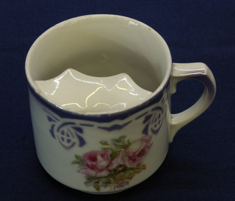
moustache cup, late 19th - first half 20th century
The moustache cup is a drinking cup with a semicircular ledge inside. The ledge has a half moon-shaped opening to allow the passage of liquids and serves as a guard to keep moustaches dry. It is generally acknowledged to have been invented in the 1860s by British potter Harvey Adams (born 1835). Moustaches flourished throughout the Victorian era. Men often applied great gobs of melted wax to the moustache to keep it nice and stiff, with every hair in place.Between 1920 and 1930, moustaches progressively began to go out of fashion and hence moustache cup production gradually dwindled. This cup is an example of a common domestic item of its time. The Nixon families were among the earliest settlers on the Snowy River.A drinking cup with a semi-circular ledge inside - a moustache cup. It is white with a mauve stencilled border design and pink roses in the centre.Bottom - 34 472/5moustache-cup china domestic-items crockery -
 Ringwood and District Historical Society
Flyer, Stillwell & Stephens Pty. Ltd, Brochure - Multiple Properties for Public Auction at Box Hill, Ringwood, Wonga Park and Clarinda - 28th November, 1934
Seven-page brochure advertising Mortgagees' Realising Sale by Public Auction on Wednesday, 28th November, 1934 for properties at Box Hill, Ringwood, Wonga Park, and Clarinda (via Oakleigh), including photographs, property descriptions, and terms of sale.Auction Commencing at 2.15 p.m. in the Orient Line Auction Rooms, 352 Collins Street, Melbourne. Solicitors: Messrs. Madden, Butler, Elder & Graham, 406 Collins Street, Melbourne. (Agents) H.P. Knight & Co. Property Salesmen and Subidivisional Experts, 315 Collins Street, Melbourne, 'Phones: Central 10615, 10616. Attractive Residential, Orchard, and Market Garden Properties, and Public Hall and School Rooms. 1. Wonga Park via Ringwood - "Holme Bush" off Warrandyte Road, Part of Lots 14 and 15, Ringwood Orchard Estate, approximatgely three miles (north) of Ringwood Railway Station - 64 Acres. 2. 17 Bishop Street, Box Hill - timber residence. 3. Greenwood Avenue, Ringwood - On East Side, 150 feet 3 inches South of Bedford Road - timber attic residence. 4. Ringwood - Wantirna Road, South-east corner of Canterbury Road - Orchard Property of approx. 11-1/2 Acres. 5. Box Hill - Whitehorse Road, South-east corner of Linsley Street - Timber building utilised as a Public Hall and Private School. 6. Clarinda vic Oakleigh, Talbot Crescent, off Centre Road - Home on 10 acres of land. -
 Ringwood and District Historical Society
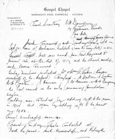
Memorabilia, Gospel Chapel Warrandyte Road , Ringwood 1927-1989, later 1 Tamar St, Ringwood
1.Hand written letter to W.H.Dempsey Secretary of the Box Hill Gospel Church with a short history of the Ringwood Church from 1917-1953. 2.Short hand written history of the Gospel Church from 1881- 1918. 3. Five letters to the Town Clerk about renting the Ringwood Town Hall for use of a Church meeting 1927 and again in 1928. Also two in March and April 1937. 4. Page of newspaper cuttings including Gospel Hall opening 5. Newspaper cutting Announcing New Church at Heathmont 21-August-1958. 6. Newpaper cutting with photo of Pastor Woodhouse with news of new child play centre. Mail 31-May-1989 7. Gospel Music Revival Centre application form. 8. Christain House 7 page typed document about the Gospel House Music Centre -
 Ringwood and District Historical Society
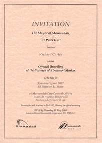
Souvenir - Mayoral Invitations, Unveiling of Borough of Ringwood Marker, 2007
Folder with two A4 invitations to unveiling ceremony and morning tea at Maroondah City Council Offices, Braeside Avenue, Ringwood, Victoria, Tuesday 5 June, 2007, showing logos of Maroondah Council and Ringwood Historical Society, co-organisers. Folder also includes Mayoress' Luncheon inviation on 23 July, 2007, at Karralyka Centre. -
 Ringwood and District Historical Society
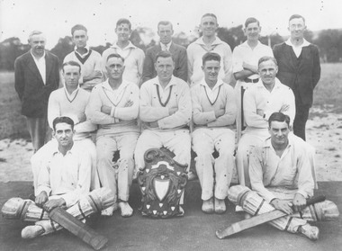
Photograph, East Ringwood Cricket Club, 1931
Written on back of photograph, "East Ringwood Cricket Club, 1931. B. Row: 1. J. Rimmer, 2. G. Cassidy, 3. J.M. Hann, 4. R. Stoney, 5. Tim Blood, 6. J. Hodgkins, 7. W. Kerr. Centre: 1. Les Perry, 2. Bert Dellas, 3. Roger Webber, 4. Bert Rimmer, 5. W. Errington. Front: Roy Cassidy, Doug Cassidy". -
 Flagstaff Hill Maritime Museum and Village
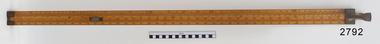
Head Rod, Dring & Fage, c. 1901
The Australian Customs Service, Melbourne, donated a set of gauging instruments, and Port Fairy Customs donated another instrument, the Sike’s Hydrometer, to Flagstaff Hill Maritime Village, all of which were no longer required. However these ullaging tools were in use for many years by Customs officials, called Gaugers. Ullaging is a term describing the measurement of the amount of liquid remaining in a container of spirits such as a cask or barrel. It can also measure the free space or head space remaining. The primary role of customs officers in Victoria was to calculate the tariff or excise duty payable on goods imported into Victoria. (Excise duty is a tax on goods produced within a country, and customs duty is imposed on imports.) Customs officers spent a great deal of their time measuring and weighing goods, and then calculating the amount of duty to be paid by the importer. The tariffs for different products varied, and officers consulted published lists. Calculating the duty payable on a barrel of brandy was a detailed task. The gauger had to measure the barrel to determine its volume. Barrels were irregular in shape, and finding the volume required several measurements and checking tables of figures. Alcoholic content was then measured with a hydrometer. The duty paid varied according to the alcoholic strength of the spirits. Uniform national customs and excise duties were operative in Australia from October 1901. These tools were still being used in Australia in the 1950’s. The Federal Government still imposes excise taxes on goods such as cigarettes, petrol, and alcohol. The rates imposed may change in February and August each year in response to changes in the consumer price index. ULLAGING TOOLS (1) Head Rod - this instrument measures the diameter of the heads (top and bottom ends) of a cask or barrel. The shaped brass pieces on the head rod enable the diameter of a barrel to be measured inside the chimes at the head end. The slide rule could then be used to calculate the internal volume of the barrel. On the reverse side is a set of ullaging scales, used like those on any ullaging rule, to calculate the volume of liquid in a partially filled barrel. (2) Bung Rod – this instrument measures the diameter of a cask or barrel when it is lying on its side. It is a rod that fits into the ‘bung’ hole of a cask and is long enough be extended to reach the opposite side of the cask. The brass sliding pointer can be moved to mark the ‘wet’ line. When the rod is removed the bung measurement can be read from the scale on the rod. (3) Long Calipers - this instrument measures the length of the cask between the heads. It has two rules sliding beside each other, each end having another piece of wood fixed firmly at right angles downwards then turned inwards at the ends so as to reach over the heads of the casks without touching the projecting ends. The centre pieces enable it to extend or contract, changing the distance between the two other parallel sides, the distance they are apart being shown by the rule on the sliding pieces. (4) Cross Calipers – this instrument is used to take the bung diameters of casks, or "the Cross " as it is called. This instrument has two rules sliding beside each other, each end having another piece of wood fixed firmly at right angles downwards, together forming a 3 sides of a rectangle with the centre pieces enabling it to extended or contracted, changing the distance between the two other parallel sides, the distance they are apart being shown by a the rule on the sliding pieces. (5) Sike’s Hydrometer – this instrument is used to gauge the strength of different alcoholic spirits when fitted with the different weights in the set. Every set is individually calibrated to ensure that it meets the exact Standard Weight and Measure compliance, then every piece in that set is stamped with the same number by the Calibrator, to ensure that the measurements are taken using the same hydrometer set. [References: A Handbook of Practical Gauging, Janes Boddely Keene of H.M. Customs, 1861, F. Pitman, London; Customs Act, Volume 2, No. 1, April 1999; Old Customs House website ] Head Rod, ullaging gauge. Long wooden rod made of three joined sections, brass hook on end, sliding centre section with hook, measurements marked along each section as on a slide rule. Used for measuring diameter of heads of casks in order for Customs to calculate excise (tax) on the contentsflagstaff hill, warrnambool, shipwrecked coast, flagstaff hill maritime museum, maritime museum, shipwreck coast, flagstaff hill maritime village, great ocean road, head rod, gauging rod, ullaging rods, measuring instruments, customs tax -
 Marysville & District Historical Society
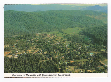
Postcard (item) - Colour postcard, K. & H. Ellis, Panorama of Marysville with Black Range in background, Pre 2009
A colour photograph of a view of Marysville in Victoria.A colour photograph of a view of Marysville in Victoria. The photograph has been taken from one of the many lookouts that surround Marysville.Panorama of Marysville with Black Range in background. Colorscans MARYSVILLE - VICTORIA Panorama of Marysville with Black/ Range in background. c PUBLISHED & PRINTED BY COLORSCAPES PUBLISHING PTY LTD 118-120 BRIGHTON STREET RICHMOND 3121 Supa-vu/ cards Photographed and Distributed by:/ K. & H. ELLIS - 35 Old Warburton Road/ Warburton 3799 20-1-81/ Dear Mum/ Just a line/ to let you know we/ have settled in here./ Its a nice park not to/ big, with a river in/ behind the van. (its/ more like a swift/ running creek, the/ kids are really enjoying/ it. There are plenty of/ walks to go on, up here/ tracks everywhere./ Hows the cooler going/ keeping you cool?/ We are able to say here until/ Sunday./ See you Mum/ Love Lois, Tom,/ & Kids. Mrs A. McTaggart/ 2 Frederick Street/ Kyabram Vic/ 3620. On reverse of postcard are 5 black marks; one in each corner and one in the centre from where the postcard has been removed from an album.marysville, victoria, postcard, souvenir, k & h ellis, colorscans publishing -
 Eltham District Historical Society Inc
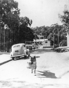
Negative - Photograph, Were Street, Montmorency, c.1948
Black and white photograph depicting a dog (named Jack) carrying newspaper delivery from the railway station up Were Street (to the Post Office). Mr. and Mrs Musselwhite ran the post office and owned Jack (the Alsatian dog) which was trained to go down to the railway station each day about 3pm and collect the daily parcel of evening newspapers, delivered by train, and take the bundle up to the newsagency. It is believed the Musselwhite's ran the Post Office from the mid 1930s to circa 1950.This photo forms part of a collection of photographs gathered by the Shire of Eltham for their centenary project book," Pioneers and Painters: 100 years of the Shire of Eltham" by Alan Marshall (1971). The collection of over 500 images is held in partnership between Eltham District Historical Society and Yarra Plenty Regional Library (Eltham Library) and is now formally known as 'The Shire of Eltham Pioneers Photograph Collection.' It is significant in being the first community sourced collection representing the places and people of the Shire's first one hundred years.Digital image 4 x 5 inch B&W Negsepp, shire of eltham pioneers photograph collection, montmorency, were street, musselwhite, newsagent, alsatian (dog), jack (dog), montmorency railway station, shopping centre, were street shops -
 Eltham District Historical Society Inc
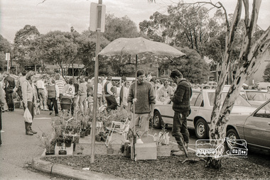
Photograph, Plant Stall, Eltham Market, Carpark, Commercial Place, Eltham, October 1988, 1988
Held in the carpark between the Safeway Supermarket and Commercial PlaceRoll of 35mm black and white negative film, 5 stripsIlford HP5art and craft market, carparks, commercial place, eltham market, safeway supermarket, shopping centre -
 Eltham District Historical Society Inc
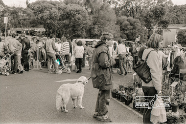
Photograph, Plant Stall, Eltham Market, Carpark, Commercial Place, Eltham, October 1988, 1988
Held in the carpark between the Safeway Supermarket and Commercial PlaceRoll of 35mm black and white negative film, 5 stripsIlford HP5art and craft market, carparks, commercial place, eltham market, safeway supermarket, shopping centre -
 Eltham District Historical Society Inc
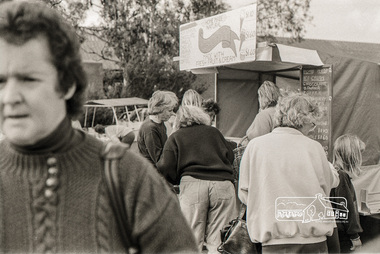
Photograph, Homemade Icecream, Eltham Market, Carpark, Commercial Place, Eltham, October 1988, 1988
Held in the carpark between the Safeway Supermarket and Commercial PlaceRoll of 35mm black and white negative film, 5 stripsIlford HP5art and craft market, carparks, commercial place, eltham market, safeway supermarket, shopping centre -
 Eltham District Historical Society Inc
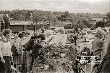
Photograph, Pottery Stall, Eltham Market, Carpark, Commercial Place, Eltham, October 1988, 1988
Held in the carpark between the Safeway Supermarket and Commercial PlaceRoll of 35mm black and white negative film, 5 stripsIlford HP5art and craft market, carparks, commercial place, eltham market, safeway supermarket, shopping centre, mac's liquor -
 Eltham District Historical Society Inc
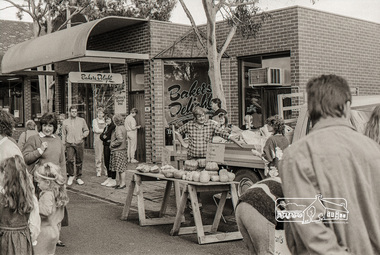
Photograph, Pumpkin Stall, Eltham Market, Carpark, Commercial Place, Eltham, October 1988, 1988
Held in the carpark between the Safeway Supermarket and Commercial PlaceRoll of 35mm black and white negative film, 5 stripsIlford HP5art and craft market, carparks, commercial place, eltham market, safeway supermarket, shopping centre, bakers delight -
 Eltham District Historical Society Inc
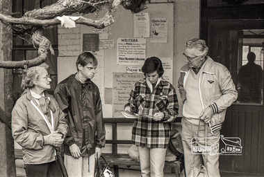
Photograph, Working Group, Eltham Living and Learning Centre, October 1988, 1988
Roll of 35mm black and white negative film, 5 stripsIlford HP5 -
 Eltham District Historical Society Inc
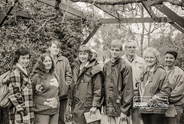
Photograph, Working Group, Eltham Living and Learning Centre, October 1988, 1988
Roll of 35mm black and white negative film, 5 stripsIlford HP5 -
 Eltham District Historical Society Inc
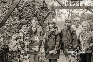
Photograph, Working Group, Eltham Living and Learning Centre, October 1988, 1988
Roll of 35mm black and white negative film, 5 stripsIlford HP5 -
 Eltham District Historical Society Inc
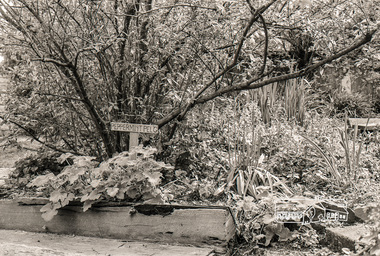
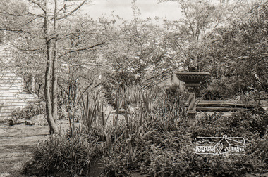
Photograph, Garden, Eltham Living and Learning Centre, October 1988, 1988
Roll of 35mm black and white negative film, 5 stripsIlford HP5eltham living and learning centre -
 Eltham District Historical Society Inc
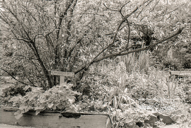
Photograph, Garden, Eltham Living and Learning Centre, October 1988, 1988
Roll of 35mm black and white negative film, 5 stripsIlford HP5eltham living and learning centre -
 Eltham District Historical Society Inc
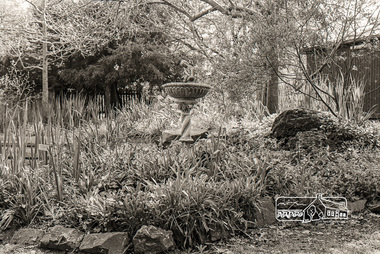
Photograph, Garden, Eltham Living and Learning Centre, October 1988, 1988
Roll of 35mm black and white negative film, 5 stripsIlford HP5eltham living and learning centre -
 Eltham District Historical Society Inc
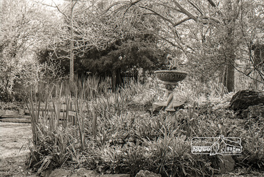
Photograph, Garden, Eltham Living and Learning Centre, October 1988, 1988
Roll of 35mm black and white negative film, 5 stripsIlford HP5eltham living and learning centre -
 Eltham District Historical Society Inc
Photograph, Garden, Eltham Living and Learning Centre, October 1988, 1988
Roll of 35mm black and white negative film, 5 stripsIlford HP5eltham living and learning centre