Showing 1441 items matching " lithographers"
-
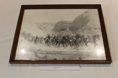 Dandenong/Cranbourne RSL Sub Branch
Print - Framed Photograph
Framed lithograph drawing of mounted soldiers in grey shade.Inscribed "The Final Dash To Damascus" H . S. Power. R.O.I ,S.A.P. -
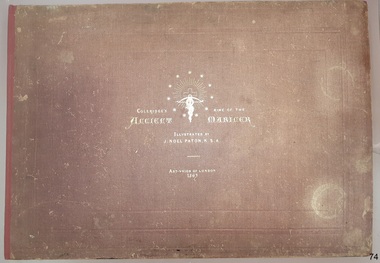 Flagstaff Hill Maritime Museum and Village
Book - Reference, Samuel Taylor Coleridge et al, Coleridge's Rime of the Ancient Mariner, 1863
This book includes the classic poem ‘Rime of the Ancient Mariner’ by Samuel Taylor Coleridge, the lines of which are set out in twelve pages of double columns. Each section of the poem is titled, such as 'Part the Sixth'. The twenty lithographed line drawings by J. Noel Paton RSA illustrate major events of the story and repeat the applicable verse below them. Most of the drawings have the initials of the artist and the lithographer on the bottom corners, below which are printed their names. The margins of the poem contain printed author's notes. Interestingly, the printer's name is added as a footnote on page 12, at the end of the poem. The book is included in the Rare Books collection of Flagstaff Hill. Its description closely matches one of two copies of the book held by the British Museum. There have been other publications of Coleridge’s poem over the years, based on various editions of his poem and illustrated by other artists. When this book was first published, Paton’s illustrations were available individually for the public to purchase. The author, Samuel Taylor Coleridge (1772-1834), was a notable late 18th to early 19th century English poet. He was the youngest of fourteen children. His father was a vicar as well as the master of a grammar school, with Samuel attended. Coleridge's longest poem, 'Rime of the Ancient Mariner', was written about 1797-1798 and tells of the experiences and adventures of a sailor. It was included in a collection of poetry titled 'Lyrical Ballads', jointly written with his friend William Wordsworth. The volume is considered the beginning of the Romantic era of British poetry. Coleridge acknowledges William Wordsworth in this poem, in ‘Part the Forth’ with the footnote “For the two left lines of this stanza, I am indebted to Mr Wordsworth. It was on a delightful walk from Nether Stowey to Dulverton, with him and his sister, in the autumn of 1797, that this poem was planned, and in part composed”. Sir Joseph Noel Paton RSA (1821-1901) is a well-known Scottish-born artist and painter of historical artwork, created the line illustrations in 1863, highlighting the main points of the poem. In the same year he also illustrated Charles Kingsley's 'Water Babies'. He was appointed Queen’s Limner for Scotland from 1866. The book was published in 1863 by the Art Union of London, an organisation whose members paid an annual subscription, and who received an annual prize of a work of art. The organisation was established in 1837 and membership quickly grew until the 1870's. Membership then slowly dropped off until the organisation was would up in 1912. Lithographer William Husband McFarlane, of Edinburgh, Scotland, created the black and white lithograph outlines from Paton’s drawings, illustrating many of the lines of the poem. The book of poetry and Illustrations was then printed by Neill & Company, Edinburgh, in 1763. The company was formed by Patrick Neill in 176. The company was known for inventing one of the early mechanical typesetting machines, which was used for the Company's publications as well as sold to other companies even into the early 1900s. The firm continued in business until 1973. This copy of the book was presented to Emily Taylor Smith by her father on September 16, 1867, four years after it was published. There is no further information available about Emily at this point in time.This Victorian era book of poetry with illustrated prints, the 'Rime of the Ancient Mariner' by Samuel Taylor Coleridge, is considered to be a rare book. The British Museum holds two copies, one of which is very similar in description. The book is significant for containing a poem written by the renowned British poet Samuel Coleridge, who acknowledges the contribution of a couple of the lines to his friend William Wordsworth. The book's significance is increased for being included in a collection of poetical works jointly written by Coleridge and his friend William Wordsworth, entitled 'Lyrical Ballads' and published in 1797. The printer of the book, Neill & Company, was known for pioneering an early mechanical typesetting machine. It’s significance also includes the collection of Victorian artwork within. Coleridge's poem is significant for being included in 'Lyrical Ballads', which is considered to signify the beginning of the Romantic era of British poetry. Book: large, burgundy linen covered, hard cover, with gold embossed title and images, landscape orientation. Title: Coleridge's Rime of the Ancient Mariner. Author: Samuel Taylor Coleridge Illustrator: J. Noel Paton, R.S.A. Publisher: Art-Union of London in 1863. Lithographer: W.H. McFarlane in Edinburgh, Scotland, 1863. Printer: Neill & Company, Edinburgh, Scotland Contents include the lines of a poem, with lithograph illustrations above applicable short verse. The cover and fly page have the same emblems. A personal inscription is hand written in nib pen inside the book.Printed: "COLERIDGE'S RIME OF THE ANCIENT MARINER" "ILLUSTRATED BY J. NOEL PATON, R.S.A." "ART-UNION OF LONDON, 1863" " W.H. McFARLANE, LITHOGr, EDINBURGH" "Printed by Neill & Company, Edingurgh" Emblems embossed on cover, and a repeat printed on fly page, include stars encircling a crucifix and a snake entwined around a cross bow with a branch in its mouth.flagstaff hill, warrnambool, flagstaff hill maritime museum, maritime museum, shipwreck coast, flagstaff hill maritime village, great ocean road, coleridge's rime of the ancient mariner, rime of the ancient mariner, ancient mariner, samuel coleridge, j. noel paton, art-union of london, 1863, rare book, samuel taylor coleridge, art union of london, w.h. mcfarlane, william husband macfarlane, sir joseph noel paton, poem, emily taylor smith, 1867, romantic period, william wordsworth, lithograph, poetry, lyrical ballads, british romantic movement, literary work, neill & company edinburgh, j. noel paton rsa, mechanical typesetting, alexander neill fraser, mechanical typesetting machine -
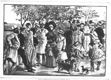 St Kilda Historical Society
Artwork, other - Lithograph, St Kilda Esplanade, 20/05/1882
20 May 1882black and white lithograph, unmounted copy, very good conditionSuburban Sketches: St Kilda Esplanade on a Saturday afternoon -
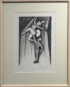 Federation University Art Collection
Work on paper - Printmaking - Lithograph, 'Adagio' by John Brack, 1967
This item is part of the Federation University Art Collection. The Art Collection features over 2000 works and was listed as a 'Ballarat Treasure' in 2007.Framed black and white lithograph of a male and female circus performer. Lower edge " 60/200 John Brack"art, artwork, john brack, printmaking, circus, edition, lithograph, available -
 Federation University Art Collection
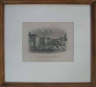
Printmaking - Lithograph, 'Lydiard St from Bath's Hotel, Ballarat' by S.T. Gill, 1857
This item is part of the Federation University Art Collection. The Art Collection features over 2000 works and was listed as a 'Ballarat Treasure' in 2007.Framed lithograph depicting people on Lydiard Street South, Ballarat art, artwork, ballarat, lydiard street, s.t. gill, samuel thomas gill, available, bath's hotel, craig's hotel -
 Federation University Art Collection
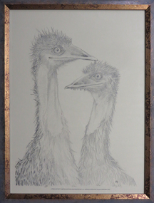
Lithograph, Earl Ingleby, 'Emu' by Earl Ingleby
This item is part of the Federation University Art Collection. The Art Collection features over 1000 works and was listed as a 'Ballarat Treasure' in 2007..2) of a group of 3 framed lithographs. This work depicts an emu.On lower side "5/50 Emu Litho E. Ingleby"art, artwork, earl ingleby, emu, bird, lithograph, available -
![Artwork, [Cityscape]](/media/collectors/530576742162ef0fa09a2288/items/534748189821f420f8c03a86/item-media/599681af21ea6912a8bde7fe/item-fit-380x285.jpg) Federation University Art Collection
Federation University Art CollectionArtwork, [Cityscape]
This item is part of the Federation University Art Collection. The Art Collection features over 2000 works and was listed as a 'Ballarat Treasure' in 2007.Framed coloured lithograph on paper showing a busy city street.Signed lower left 'Barry Pillar'art, artwork, barry pillar, cityscape, streetscape, requires framing -
 Federation University Art Collection
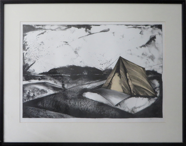
Work on paper - Artwork - Printmaking, 'Birds Ignite Across the Air' by Kaye L. Green, 1987
Kaye L. GREEN (1953- ) Kaye L. Green was a lecturer in printmaking at the Gippsland Centre for Art and Design. Framed limited edition planographic lithograph depicting a landscape with tents.Signed and dated lower right in pencil "Kaye L. Green '87"printmaking, gippsland campus, churchill, kaye l. green, kaye green -
 Federation University Art Collection
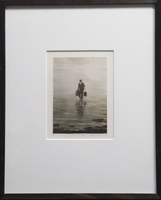
Print, Louise Tomlinson, The Crossing, 1999
Louise TOMLINSON (1964- ) Born Tongala, Victoria In 1980 Louise Tomlinson decided to relocate to Ballarat to study fine artFramed lithograph depicting a man carrying bags through water.LL1/25 Centre "The Crossing" LR Thomlinson '98available, alumni -
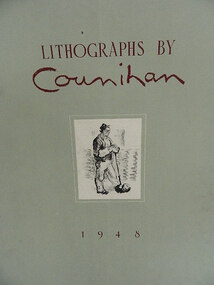 Bass Coast Shire Council - Robert Smith Collection
Artwork, other - A Metal Pourer 1948, Noel Counihan
Australia 1913 - 1986Zinc-plate lithograph tipped onto cover s.14 -
 Clunes Museum
Artwork, other - LITHOGRAPH, S.T. GILL, MINER AT FRYERS CREEK, UNKNOWN
FROM A PAINTING BY S.T. GILL. ORIGINAL IN STATE LIBRARY OF VICTORIACOPY OF LITHOGRAPH OF A MINER AT FRYERS CREEK, MT. ALEXANDER DIGGINGSlocal history, illustration, lithograph, mining -
 Marysville & District Historical Society
Map (Item) - Tourist Map, Tourists Resorts' Committee, Tourist's Map of Healesville Marysville and Warburton Districts, 13.10.1925
A tourist map for Healesville, Marysville and Warburton that was produced by the Tourists Resorts' Committee. This map was produced in 1925.A tourist map for Healesville, Marysville and Warburton that was produced by the Tourists Resorts' Committee.Photo Lithographed at the Department of Lands and Survey, Melbourne by W.J. Butson./ 13.10.25healesville, marysville, warburton, victoria, tourists resorts' committee, ben cairn, mount donna buang, the black's spur, the acheron valley, narbethong, launching place, tourist information, tourism, map, tourist map -
 Bendigo Historical Society Inc.
Map - JACK FLYNN COLLECTION: VILLAGE OF BETLEY, 30/06/1874
Map: Village of Betley, on the Bet Bet Creek, Parish of Dunolly. Parish plan.Photo Lithographed at the Department of Lands and Survey Melbourne by J. Noone 30.6.74map, gladstone, village, betley, bet bet creek, dunolly -
 Bendigo Historical Society Inc.
Map - JACK FLYNN COLLECTION: BAMAWM, 19/08/1924
Map: Parish of Bamawm, County of Bendigo. Parish plan.Photo Lithographed at the Department of Lands and Survey, Melbourne by W.J. Butson. 19.8.24map, bendigo, parish plan, bamawm -
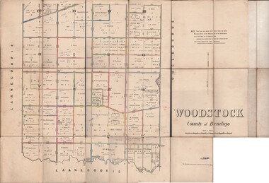 Bendigo Historical Society Inc.
Map - JACK FLYNN COLLECTION: WOODSTOCK, 27/03/75
Map: Parish of Woodstock , County of Bendigo. Parish plan.Photo-Lithographed at the Department of Lands and Survey Melbourne by J. Noone. 27.3.79map, bendigo, parish plan, woodstock -
Stawell Historical Society Inc
Map, T.F. McGauran, William Couty of Borong 1891, 1891
Stawell Water Supply Reserve. Grampians State Forest. Dairy Creek, Fyans Creek, Barney's Creek, Bovine Creek, Glasstree Creek, Stoney Creek. Stawell Water Supply Aquaduct Fkuming Tunnel.A2 Parish Map of Willam Inculdin Stawell Water Supply Reserve and Creeks. Marked in redPhoto Lithographed at the Department of Lands and Survey Melbourne. By T.F. McGauran 20.07.91 water supply survey -
Stawell Historical Society Inc
Map, T.F. McGauran, Winjallock County of Kara Kara, 1900
Noth of Navarre and BarkleyA2 Map0f Parish of Kara Kara.Photo Lithographed and the department of Lands & Survey, Melbourne by T.F. McCauran 22.10.00survey -
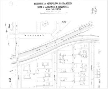
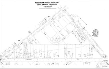 Camberwell Historical Society
Map (Item) - MMBW map, Melbourne and Metropolitan Board of Works, Melbourne and Metropolitan Board of Works - Shire of Boroondara and Camberwell - Detail Plan no. 1851, July 1904
Lithographer JEM, exd. JWD, July 1904, no. 81, 40P. 15W.melbourne and metropolitan board of works, map, camberwell, cartography -
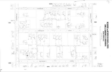
 Camberwell Historical Society
Map (Item) - MMBW map, Melbourne and Metropolitan Board of Works, Melbourne and Metropolitan Board of Works - Shire of Boroondara and Camberwell - Detail Plan no. 1852, August 1904
Lithographer L.E, exd W.A.L., August 1904, no. 95. 40P. 15Wmelbourne and metropolitan board of works, map, camberwell, cartography -
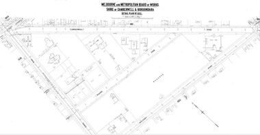
 Camberwell Historical Society
Map (Item) - MMBW map, Melbourne and Metropolitan Board of Works, Melbourne and Metropolitan Board of Works - Shire of Boroondara and Camberwell - Detail Plan no. 1858, August 1904
Lithographer E.H.H., Exd J.W.D, Aug 1904, No. 103. 40P.15W.melbourne and metropolitan board of works, map, camberwell, cartography -
 Camberwell Historical Society
Map (Item) - MMBW map, Melbourne and Metropolitan Board of Works, Melbourne and Metropolitan Board of Works - Shire of Boroondara and Camberwell - Detail Plan no. 1845, August 1904
Lithographer JEM, exd. JWD, June 1904, no. 71. 40P.15W.melbourne and metropolitan board of works, map, camberwell, cartography -
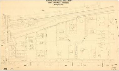 Camberwell Historical Society
Map (Item) - MMBW map, Melbourne and Metropolitan Board of Works, Melbourne and Metropolitan Board of Works - Shire of Boroondara and Camberwell - Detail Plan no. 1860, August 1904
Lithographer E.H.H., Exd J.W.D, June 1904, No. 70. 40P.15W.melbourne and metropolitan board of works, map, camberwell, cartography -
 Bacchus Marsh & District Historical Society
Map, Parwan Parish Map, County of Grant, 1909
A single page paper map showing the map for the Parish of Parwan in the County of Grant. A cadastral map showing parish boundaries and land ownership. The map is pasted into a bound volume containing 76 maps or plans in total. High resolution digital image stored on BMDHS computer network. Photo-lithographed at the Department of Lands and Survey, Melbourne by T.F. McGauran, 7.7.09. bacchus marsh region parish plans, parwan parish maps, parwan parish plan -
 Bacchus Marsh & District Historical Society
Map, Trentham Parish Map 1905 Copy 1
A single page paper map showing the map for the Parish of Trentham in the Counties of Dalhousie and Bourke. A cadastral map showing parish boundaries and land ownership. The map is pasted into a bound volume containing 76 maps or plans in total. High resolution digital image stored on BMDHS computer network. Photo-lithographed at the Department of Lands and Survey, Melbourne by T.F. McGauran 22.3.05 trentham parish maps, trentham parish plan, bacchus marsh region parish plans -
 Bacchus Marsh & District Historical Society
Map, Blackwood Parish Map, County of Bourke, 1892
A single page paper map showing the map for the Parish of Blackwood in the County of Bourke. A cadastral map showing parish boundaries and land ownership. The map is pasted into a bound volume containing 76 maps or plans in total. High resolution digital image stored on BMDHS computer network. Photo-lithographed at the Department of Lands and Survey, Melbourne by T.F. McGauran 14.7.92bacchus marsh region parish plans, blackwood parish plan, blackwood parish maps -
 Bacchus Marsh & District Historical Society
Map, Blackwood Parish Map, County of Bourke, 1905
A single page paper map showing the map for the Parish of Blackwood in the County of Bourke. A cadastral map showing parish boundaries and land ownership. The map is pasted into a bound volume containing 76 maps or plans in total. High resolution digital image stored on BMDHS computer network. Photo-lithographed at the Department of Lands and Survey, Melbourne by T.F. McGauran 21.7.05bacchus marsh region parish plans, blackwood parish plan, blackwood parish maps -
 Bacchus Marsh & District Historical Society
Map, Myrniong Parish Map, County of Bourke, 1882
A single page paper map showing the map for the Parish of Myrniong in the County of Bourke. A cadastral map showing parish boundaries and land ownership. The map is pasted into a bound volume containing 76 maps or plans in total. High resolution digital image stored on BMDHS computer network. Photo-lithographed at the Department of Lands and Survey, Melbourne by J. Noone, 17.7.82myrniong parish plan, myrniong parish maps, bacchus marsh region parish plans -
 Bacchus Marsh & District Historical Society
Map, Parish of Yangardook, County of Bourke 1876
The parish of Yangardook lies directly north of the township of Melton. The locality of Toolern Vale lies in the centre of this parish. A single page paper map showing the plan for the Parish of Yangardook in the in the County of Bourke. Scale 40 chains to 1 inch. The map is pasted into a bound volume containing 76 maps or plans in total. High resolution digital image stored on BMDHS computer network. Photo lithographed at the Department of Lands and Survey, Melbourne by J. Noone, 1.8.76yangardook parish maps, toolern vale victoria maps -
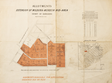 Merbein District Historical Society
Map - Allotments Extension of Mildura-Merbein Mid-Area, Allotments available, 23 November 1920
Allotments available to Discharged Soldiers Discharged Soldier's Settlement Act Historic Large map, folded in 4, coloured map of Merbein indicating allotments available and locality plan. Scale 10 chain to 1 inchPhoto-Lithographed at Department of lands Survey, Melbourne J. Butson 23.11.20discharged soldiers, ww1, soldier settlement, irrigation