Showing 2275 items
matching parish.
-
 Merbein District Historical Society
Newsletter, Journal of the Sunraysia Parish Uniting Church - Vol 6 No 9, Oct.1993
sunraysia, uniting church, churches -
Merbein District Historical Society
Newsletter, Journal of the Sunraysia Parish Uniting Church - Vol 15 No 5 (2 copies), 2001
churches, uniting church, gordon midgley -
Merbein District Historical Society
Newsletter, Journal of the Sunraysia Parish Uniting Church - Vol 15 No 4 (2 copies), 2001
churches, uniting church -
Merbein District Historical Society
Administrative Record, Ledger, Irrigation Rate Book - Merbein (Parish), 1921-1929
township, state rivers and water supply commission -
Merbein District Historical Society
Administrative Record, Ledger, Irrigation Rate Book - Merbein (Parish), 1917-1920
township, state rivers and water supply commission -
Merbein District Historical Society
Administrative Record, Ledger, Irrigation Rate Book - Merbein (Parish), 1935-1938
township, state rivers and water supply commission -
Merbein District Historical Society
Newsletter, Journal of the Sunraysia Parish Uniting Church - Vol 15 No 6 (2 copies), Sep.2001
harold frederick rudolf brinsden -
Merbein District Historical Society
Newsletter, Journal of the Sunraysia Parish Uniting Church - Vol 15 No 7, Oct.2001
merbein combined churches-centenary of federation -
Merbein District Historical Society
Newsletter, Journal of the Sunraysia Parish Uniting Church - Vol 15 No 8, 16 Dec.2001
churches -
Merbein District Historical Society
Newsletter, Journal of the Sunraysia Parish Uniting Church - Vol 16 No 1, 27 Jan.2002
churches, dorothea hilda herath -
Merbein District Historical Society
Newsletter, Journal of the Sunraysia Parish Uniting Church - Vol 16 No 2, 10 Mar.2002
churches -
Merbein District Historical Society
Newsletter, Journal of the Sunraysia Parish Uniting Church - Vol 18 No4, Aug.2003
-
Merbein District Historical Society
Newsletter, Journal of the Sunraysia Parish Uniting Church - Vol 18 No 1, 23 Feb.2003
-
Merbein District Historical Society
Newsletter, Journal of the Sunraysia Parish Uniting Church - Vol 18 No 3, 22 Jun. 2003
john william hopper bennett, ernest hudson, norma webb -
Merbein District Historical Society
Newsletter, Journal of the Sunraysia Parish Uniting Church - Vol 16 No3, 21 Apr.2002
ron mitchell, fred curtis -
Merbein District Historical Society
Newsletter, Journal of the Sunraysia Parish Uniting Church - Vol 16 No4, 9 Jun.2002
janet henderson -
Merbein District Historical Society
Map, Parish of Merbein - Irrigation Allotments, 3 Aug.1912
irrigation -
Merbein District Historical Society
Newsletter, Journal of the Sunraysia Parish Uniting Church - Vol 19 No 1, Easter 2004
lindsay adams, mavis bennett, william duncan kennedy -
Merbein District Historical Society
Document, Bill of sale Allotment 20 & 21 Parish of Wargan, 14 Sept.1953
h.j. hunt -
 Ringwood and District Historical Society
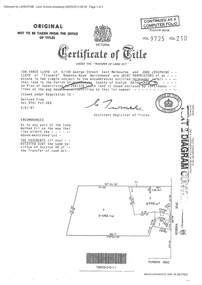
Document - Certificate of Title and Maroondah Heritage Study, "Elouera", 59 Bemboka Road, Warranwood, Victoria, previously part of Crown Section 20, Parish of Warrandyte, County of Evelyn - 4th February, 1987
Property subsequently subdivided into residential allotments with formation of Aspen Court, Warranwood, circa 2010.A4 copies of Landata Victoria documents - Vol 9725 Fol 210 derived from Vol 9701 Vol 469, and 2-page Heritage Study report.Ian Vance Lloyd and June Josephine Lloyd are joint proprietors of an estate in fee simple - Lot 4 on Plan of Subdivision no.204137B shown on the map. Subdivision includes Bemboka Road. Encumbrance E-1 later extended through Lot 4 as Aspen Court. Transfer - Proprietor June Josephine Lloyd - 29 July, 1993. Documents include 2-page Heritage report for study conducted prior to subsequent Aspen Court residential development circa 2010. -
University of Melbourne, Burnley Campus Archives
Plan (Item), Plan of Burnley Gardens, City of Richmond, Parish of Jika Jika, County of Bourke, 1948
(On original) : Notes by W(?) Anderson 28/2/45. Date stamp of School of Primary Horticulture and Agriculture Burnley E1burnley gardens, richmond, department of lands & survey, orchard -
 Ringwood and District Historical Society
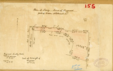
Map, Plan of Survey, Parish of Ringwood - Part of Crown Allotment 31A - 1950
Hand drawn and labelled copy of map with survey measurements of allotment on Isobel Avenue (Isabel Avenue?), Ringwood East. Raymond Dudley Steele Licensed Surveyor 10-8-50, signed 6-9-50, Seal of Borough of Ringwood 26-9-50. Rubber stamp - Dugdale, Simmons & Stevens, Solicitors, Peacock House, 486 Bourke Street Melbourne. Typewritten heading on backing paper - Capt. M.H. Moyes - Correspondence Supplementary to Statements. -
 Ringwood and District Historical Society
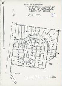
Map - Plan of Subdivision, Part of Crown Allotment 27B Parish of Warrandyte County of Bourke (undated, circa 1970)
Photocopied subdivision map of 38 residential allotments in Glenvale Road, Cantala Crescent, and Giana Court, north of Kubba Road, Ringwood. -
 Ringwood and District Historical Society
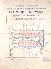
Map - Plan of Subdivision, Parts of Crown Portions 10 and 10B Parish of Ringwood - 1958
Folded subdivision map of 15 residential allotments in McKay Court Ringwood, off Wantirna Road north of Canterbury Road. Rubber stamped by Surveyors and Chartered Engineers J.S. Watson & Associates, Mornington and South Yarra, with illegible signature dated 17/2/58. Handwritten notations indicating allotment sale names and amounts or where passed in.Scale 80 feet to an inch. -
 Falls Creek Historical Society
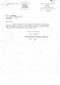
Letter - Letter Re Diagram Of Governor Phillip Park, Parish Of Narrabeen
Bob Hymans Collection Bob (Herman) Hymans (a former member of the Royal Netherlands Navy) was born in Bloemendaal, Holland on 30th September 1922. During World War II he fought against the Japanese in the Dutch East Indies (now Indonesia) and was imprisoned in Changi and on the Burma Railway. After gaining qualifications as a Ski Instructor, Bob arrived in Falls Creek in July 1950. Working as an Instructor and Supervisor at Bogong Lodge, Bob decided his future was in accommodation. He was successful in negotiating an indenture for land from the State Electricity Commission (SEC). It took Bob two years to build his Grand Coeur Chalet but, tragically, it was burned down in August 1961. Bob also built the first Chairlift in Australia. This was a single chairlift and the structure was built from wooden electricity poles. He was constantly full of new ideas and proposals for the village. Bob Hymans died on 7th July 2007. This Collection of documents and letters tells the story of Bob's endeavours to develop Falls Creek into the ski village it is today.This letter is significant because it reflects the desire for Bob Hymans to consider projects outside of Falls Creek.A letter from Department of Lands, New South Wales accompanying a diagram of Governor Phillip Park. Plans are no longer available.falls creek administration, governor phillip park -
Lakes Entrance Historical Society
Book, Cocks Coral Morton Julie, Lindenow South in the Parish of Coonbulmerang 1889-1989, 1989
Discription of Historic events of the area of Lindenow South Comprehensive photograph collection of shool children football teams fire brigades. Period covered 1889-1989 gives school pupil lists for years 1889-1989schools, emergency services -
 Ringwood and District Historical Society
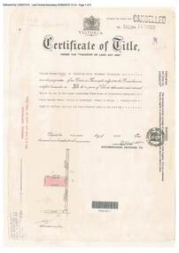
Document, Certificate of Title - W.G. Carter, Grandview Grove, Warranwood, Victoria, (later Bemboka Road) - part of Crown Section Twenty, Parish of Warrandyte, County of Evelyn - 1947
A4 copies of Landata Victoria Historical Search documents - Vol 7052 Fol 1410222. Includes Carter Family Tree property notes. William George Carter of Grandview Grove Ringwood, Nurseryman, is now the proprietor - three acres or thereabouts shown on map (12202a) - 14th March, 1947. Transfer B284834 Registered 21 September, 1961 - 1 acre shown on map (12202c) north of Plymouth Road. NOTES ON GRANDVIEW GROVE PROPERTY (Carter Family Tree extract) The Grandview Grove property was purchased by William (Bill) and Doreen Carter in 1947 as three acres of uncleared bushland. They had a 2 bedroom fibro-cement house built on the land which they informally called "Willoreen". With Doreen looking after sons Peter (born in 1940) and Robin (born in 1950), Bill worked locally at Croydon Dairy. The family spent much of their spare time clearing the land, where Bill then grew and sold fruit, flowers and berries, particularly strawberries, as a hobby and to supplement their income. Bill continued to do so while Peter and Robin were growing up, and after Doreen died in 1958. In 1961 Bill sold one of the three acres to one of his seven sisters, Grace, who lived in Kew but later moved to Rosebud and sold the land without ever building on it. During the 1960s, Grandview Grove was renamed Bemboka Road. After retiring as a milkman, Bill moved to Rosebud, Vic, and in 1977, sold the property to the Anglican Church, who were looking to invest in the site in anticipation of proposed future residential development in the area. As nearby properties were subdivided during the 1980s, the house, which the Church had initially utilised as low-cost family accommodation, was modified internaly to become a church/Sunday school. By the early 2000s, construction of a contemporary-design church and carparking area between the house and street alignment had been completed but the house remained as a detatched meeting room until falling into disrepair and was eventually demolished around 2010. -
 Ringwood and District Historical Society
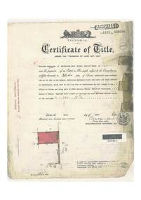
Document, Certificate of Title - Thomas Arthur Wentworth Burkitt - part of Crown Section 20, Parish of Warrandyte, County of Evelyn - 1st April, 1919
A4 copies of Landata Victoria Historical Search documents - Vol 4197 Fol 839286.Winifred Cambridge of Balwyn, Married Woman, is now the proprietor of an Estate in Fee-simple subject to the Encumbrances notified hereunder ... 17 acres 2 roods 3 perches or thereabouts, being part of Lot 9 on plan of subdivision no.4315, Bemboka Road, Warranwood, Victoria. Encumbrance comment "Appurtenant to carriageway over Omeo Parade on LP12040". Transfers include John Collins of Brysons Road Ringwood, Farmer - 16th June, 1944, Kevin Collins of Warranwood, Carrier - 20th September, 1951, Francis Mohan of St.Kilda - 19th January, 1968, Vivian Campbell Rush, Engineer, and Dorothy May Rush, Married Woman, both of Main Road, Warrandyte, joint proprietors, and Alan Humphrey Croxford, Gentleman, and Eleanor Pearl Croxford, Married Woman, both of Pound Road, Warrandyte, joint proprietors as Tenants In Common - 31st March, 1969, Transferred as to the interest of Alan Humphrey Croxford and Eleanor Pearl Croxford - 13th July, 1973. (See Alan Humphrey Croxford biography link https://adb.anu.edu.au/biography/croxford-alan-humphrey-12375) -
 Federation University Historical Collection
Plan, Camp Street Ballarat Parish Plan
Camp Street was the site of the original goldfields camp reserve, and it is from here that soldiers and police troopers left to attack the Eureka Stockade on 03 December 1854.PLan of Camp Street Ballaratcamp street, police reserve, old colonists' association, grenville street, lydiard street north, t. cowan, r. surtees, c.m. watson, w.h. foster, j.b. humffray, j.j. goller, h.r. caselli, henry caselli, market reserve, e.v. gribble, old colonists' association of ballarat -
Clunes Museum
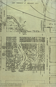
Map, Township of Clunes - Parish of Clunes - County of Talbot
Map of Clunes Township in 19511 X PHOTOCOPY OF MAP, (COMPRISING A NUMBER OF A4 SHEETS TAPED TOGETHER) SHOWING LOT NUMBERS AND NAMES OF LANDHOLDER. REFERENCE GAZ 1951.1480. SCALE 30 CHAINS = 1 INCH 1 X PHOTOCOPY OF MAP, (COMPRISING A NUMBER OF A4 SHEETS TAPED TOGETHER) SHOWING LOT NUMBERS AND NAMES OF LANDHOLDER. REFERENCE: G76359 GENERAL FILE TOWNSHIP RESIDENTIAL ALLOTMENTS SCALE 30 CHAINS = 1 INCHNOTATED IN PURPLE CRAYON ON SECOND MAP: AS AT LATE 1984 COPY OF MAP FROM LAND TITLES OFFICE BALLARATtownship of clunes map, 1951