Showing 10928 items matching " plan"
-
 Stawell Historical Society Inc
Map, Plan of Agricultural Areas of Western Districts, 1865
Plan of Agricultural Areas of Western Districtsstawell -
 Melton City Libraries
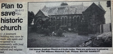
Newspaper, Plan to save historic church, 1993
Plans to save the Anglican Church in Meltonchurches, local architecture -
 Federation University Historical Collection
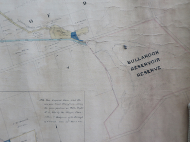
Plan, Creswick Water Supply from Bullarook to Creswick, 02/10/1869
Probably gazetted on 12 April 1872 (pg 737)Large horizontal paper plan glued in three sections to a linen backing. Coloured plan shows pipe and rack track from the Bullarook Reservoir to Albert Street, Creswick. Attached with ribbon top left are twelve pages giving bearing and lengths / descriptions of pipe and rack track. Five information boxes drawn along the bottom of plan gives extra information where pipe passes through private properties. Main heading 'Plan of Creswick Water Supply / scale eight chains to an inch / County of Talbot / Parish of Creswick'. Calculations and hand written notes in ink and pencil also on plan. Verso 'Dean Reservoir'. Signed and dated.creswick, water supply, bullurook reservoir, dean, bush inn, hesken, rivers, warner, taylor, gillard, mccormack, mcdonald, brown, naples, humbug hill sluicing co, frank rivers, w.r. taylor, j. and m. mccormack, j. mcdonald, richard brown, c. naples -
![Map, Plan of Subdivision of Crown Portion 23 & parts 24-25, Parish of Korkuperrimul [1900s?]](/media/collectors/5e461d8021ea67224c82f2a1/items/675fe058304668462205d4fb/item-media/675fe0ef304668462205d7d6/item-fit-380x285.jpg) Bacchus Marsh & District Historical Society
Bacchus Marsh & District Historical SocietyMap, Plan of Subdivision of Crown Portion 23 & parts 24-25, Parish of Korkuperrimul [1900s?]
The Parish of Korkuperrimul includes a significant section of the township of Bacchus Marsh and extends in western and northern directions from the township area. The date of the subdivision indicated on this plan has not been established. The engineer's stamp on the drawing shows the firm of Muntz and Muntz who were operating under that name in the early part of the 20th century.A single page paper map showing 20 blocks of land for sale in the Parish of Korkuperrimul. Scale 100 feet to 1 inch. The map is pasted into a bound volume containing 76 maps or plans in total. High resolution digital image stored on BMDHS computer network. Stamped: 'Muntz & Muntz Civil Engineers, Architects & Surveyors, Trustees Chambers ?? Cor Collins Street and Bank Placeland sales bacchus marsh, bacchus marsh victoria maps, land sales korkuperrimul parish -
University of Melbourne, Burnley Campus Archives
Work on paper (item) - Student Work, Sandra Brizga, Andembach - Riverside Garden Planting Plan, 8 November 2018
Made as an assignment for HORT90035, a subject at Burnley Horticultural College coordinated by Andrew Laidlaw. assignment, burnley horticultural college, hort90035 -
Clunes Museum
Document - REPORT, NADIA GASPARETTO et al, CLUNES TOWN HALL AND COURT HOUSE CONSERVATION PLAN, MAY 2000
THE HISTORY AND CONSERVATION POLICY IS AIMED AT RETAINING AND CONSERVING THE BUILDINGCONSERVATION PLAN OF CLUNES TOWN HALL AND COURT HOUSE COMPILED BY NADIA GASPARELTO , ARCHITECT AND HEPBURN SHIRE COUNCIL, INCLUDING PLAN OF BUILDINGLIST OF ILLUSTRATIONS AND PHOTOSclunes town hall, clunes courthouse -
 Vision Australia
Plan - Image, Royal Victorian Institute for the Blind Extension to Bulk Store, 27/8/1925 (according to Mosiac entry)
In this undated drawing, believed to have been done in 1925, an existing bluestone store was extended out into the courtyard area. The extensions were on the south and west elevations, and the drawing includes a floor plan of these areas. Noted on the plan is the removal of fireplaces that existed in this building, the location abutting the Alfred Hospital reserve and location of the motor room.1 architectural plan of extension to bulk storeStephenson & Meldrum, Architects 374 Little Collins Street Melbourne Phone: 6990 On the back: Widening of old bluestone store plans & specroyal victorian institute for the blind, plans -
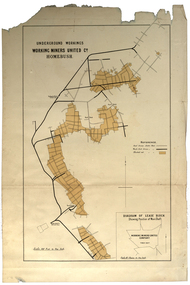 Federation University Historical Collection
Plan, Underground Workings, Working Miners United Co. Homebush
Printed map on paper various measurements and locationsunderground workings, plan, working miners united co, homebush -
Federation University Historical Collection
Plan, School of Mines Ballarat
Watercolor architectural drawing on paper depicting the Ballarat School of Mineslower left corner "Drawn by H.L Coburn: 1915"coburn, architecture, ballarat school of mines, plan -
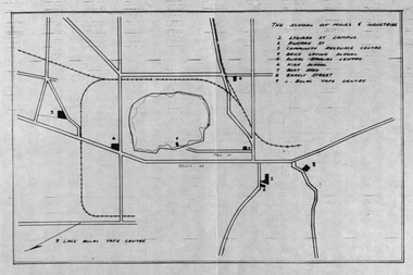 Federation University Historical Collection
Plan, School of Mines and Industries: Location of buildings, Ballarat
Printed map showing Ballarat School of Mines locations.ballarat school of mines, plan, ballarat, lake wendouree -
University of Melbourne, Burnley Campus Archives
Plan, St James Park Feature Plan, 1983
City of Hawthorn Plan, drawing No P24/19, Sheet 1 of 1. Surveyed by L.B. & H.K. Traced by H.K. Aug 83. Scale 1:500.st james park, city of hawthorn, central gardens hawthorn -
University of Melbourne, Burnley Campus Archives
Plan, Ratio Consultants Pty. Ltd, Conceptual Subdivision & Garden Layout Plan Project 'Rosecraddock' Rosecraddock Place Caulfield, 1991
Tracing paper plan by Ratio Consultants Pty. Ltd., for Mr P. Shellard, Project No 1887, drawing No LS3, October 1991. Scale 1:250.p. shellard, caulfield, ratio consultants, "rosecraddock", subdivision plans, landscape design -
University of Melbourne, Burnley Campus Archives
Plan, Plan of the Melbourne Botanic Gardens, 1948
Partially coloured plan on a grid. Prepared from Field Notes of Survey by F.C. Ridoutt drawn and reproduced at the Dept. of Lands & Survey, Melbourne, March 1948.f.c. ridoutt, gardens, melbourne, royal botanic gardens melbourne -
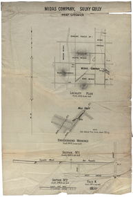 Federation University Historical Collection
Plan, Midas Company, Sulky Gully near Creswick
Locality and Underground Workings plan for the Midas Company, Sulky Gully near Creswick. Companies shown on the Locality Plan include Dowling Forest No 1., Midas Consols, Madam Midas, Midas Company, King Midas and Midas Extended.dowling forest no 1., midas consols, madam midas, midas company, king midas, sulky gully, creswick, midas extended, cgt -
 Ringwood and District Historical Society
Map, Plan of Subdivision - State School Estate, Ringwood East, Victoria - (Undated, circa 1920s)
Map of land for sale attached to green cardboard backing with handwritten notations showing numbered allotments on Dublin Road, Holland Road, King Street, Charles Street and Purser Avenue, Ringwood East.Locality plan includes reference to proposed Ringwood East railway station which opened in 1925. -
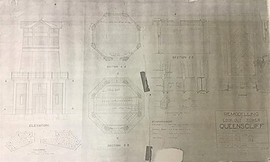 Queenscliffe Maritime Museum
Plan - Plan for a Signal Station Look-out Tower Queenscliff
A plan for the remodelling of the look-out tower at Queenscliff dated 26 April1938Plan for the the remodelling of the look-out tower at Queenscliff dated 1938plan, queenscliff, signal station, look out tower -
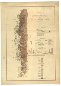 Federation University Historical Collection
Plan, Livinstone Creek and Mitta Mitta River
Plan showing geological eras and soil types. Scale 80 chains to 1 inchmitta mitta, mitta mitta river, hinnomunjie flats, mining, shafts, livingstone creek -
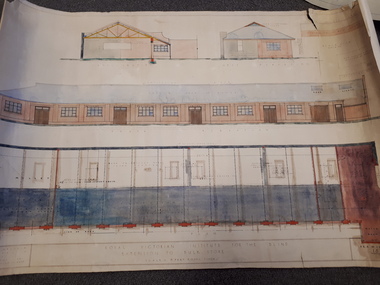
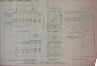 Federation University Historical Collection
Plan, Ballarat School of Mines Old Chemistry Building Plans, 1953, 02/09/1953
Short tears at righ hand endge and lower righ hand edge. Pink chemical discolouratoin on righ hand edge. Alteration plans showing llevations and sections of the Ballarat School of Mines Old Chemistry Buildings.ballarat school of mines, old chemistry building, plans, buildings, architectural plans -
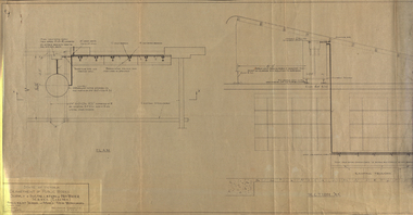 Federation University Historical Collection
Plan, Ballarat School of Mines Supply and Installation of Hot Water Service, 1941, 12/08/1941
Plan for installation of an electric hot water service into the new workshops at the Ballarat School of Mines.ballarat school of mines, new workshops, hot water, buildings, archibald fisken -
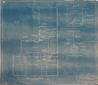 Federation University Historical Collection
Plan, Blueprint: Electric Hot Water Services, Ballarat School of MInes New Workshops, 1947
The Ballarat School of Mines is now part of Federation UniversityPlan (blueprint) for electric hot water services to new Ballarat School of Mines workshops ballarat school of mines, new workshops, electric hot water service, public works department of victoria, archectural plans -
![M.M.B.W. reticulation plan no. 731, Shire of Blackburn and Mitcham. Locality plan of bores [1933].](/media/collectors/56f368632162f118acbff12e/items/60d923316e5f99545134f002/item-media/636db48a3e324a979b36a333/item-fit-380x285.jpg) Whitehorse Historical Society Inc.
Whitehorse Historical Society Inc.Document, Locality plan of bores, 1933
M.M.B.W. reticulation plan no. 731, Shire of Blackburn and Mitcham. Locality plan of bores [1933]. Scale 1' - 160'. Ref No. S 33/154.whitehorse road, blackburn, surrey road, clare street, francis street, pope road, queen street, albert street, chapel street, bores, melbourne and metropolitan board of works -
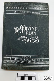 Flagstaff Hill Maritime Museum and Village
Book, Millennial Dawn Vol 1 The Plan of the Ages
Millennial Dawn Vol 1 The Plan of the Agesflagstaff hill, warrnambool, shipwrecked-coast, flagstaff-hill, flagstaff-hill-maritime-museum, maritime-museum, shipwreck-coast, flagstaff-hill-maritime-village, millennial dawn vol 1 the plan of the ages, book -
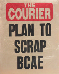 Federation University Historical Collection
Poster, Ballarat Courier Poster: "Plan to Scrap BCAE", c1988
The Ballarat College of Advanced Education (BCAE) was a predecessor institution of Federation University Australia. It was located at Mt Helen Campus and became Ballarat University College in 1990. Newspaper poster with the headline "Plan to Scrap BCAE"ballarat college of advanced education, ballarat courier, poster, ballarat university college -
University of Melbourne, Burnley Campus Archives
Document, Orchard Development Plan, c. 1983
Plan to redevelop orchard, including greenhouse areaorchard, greenhouse -
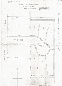 Whitehorse Historical Society Inc.
Document, Walter Wicking Plan of Subdivision, ?1952
Plan of subdivision for Wicking CourPlan of subdivision for Wicking Court, South Blackburn.Plan of subdivision for Wicking Courland subdivision, wicking court, blackburn south, wicking, walter benjamin, holland road -
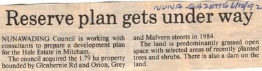 Whitehorse Historical Society Inc.
Article, Reserve plan gets under way, 6/10/1992 12:00:00 AM
Article on the development planArticle on the development plan of the Hale Estate, Mitcham.Article on the development planhale estate, mitcham, glenburnie road, orion street, vermont, grey street, malvern street, land subdivision -
Whitehorse Historical Society Inc.
Document, Wandinong Sanctuary Management Plan, 2000?
Wandinong Sanctuary Advisory Committee Management Plan.Wandinong Sanctuary Advisory Committee Management Plan.Wandinong Sanctuary Advisory Committee Management Plan.wandinong sanctuary, wandinong sanctuary advisory committee, ellemor, w r, nechwatal, janine -
Stawell Historical Society Inc
Map, Section 3 (Taken from Plan No 959), 1894
Section 3 (Taken from Plan No 959)stawell -
Stawell Historical Society Inc
Map, Section 2 (Taken from Plan No 959), 1894
Section 2 (Taken from Plan No 959)stawell -
Stawell Historical Society Inc
Map, Section 4 (Taken from Plan No 959), 1894
Section 4 (Taken from Plan No 959)stawell