Showing 1214 items matching " railway buildings"
-
 Ringwood and District Historical Society
Document - Folder, Landata Certificates - Part of Crown Portion Six, (Lots 1-4 and numbers 70-90) Maroondah Highway, Parish of Ringwood, Victoria
27 A4 pages of colour photocopied certificates with typewritten summaries, including Certificate of Title Vol 1156 Fol 231096, 8th March 1880. Certificate of Title Vol 1440 Fol 930, 14th March 1883. Certificate of Title Vol 8487 Fol 090, 28th January 1964. Certificate of Title Vol 9019 Fol 634, 5th December 1973. Certificate of Title Vol 3711 Fol 742129, William John Harnwell, 1st August 1913. Certificate ot Title Vol 6552 Fol 1310305, 5th June 1942. Certificate of Title Vol 5282 Fol 1056207, Arthur Clifton Beilby, 19th July 1927. Certificate of Title Vol 6573 Fol 1314497, Florence Beatrice McGoldrick, Lot 4 on Subdivision 14786, Whitehorse Road, Ringwood, 18th August 1942. Proprietors and transferees include: William Astley of Richmond, Compositor, Marianne Thomson of Jolimont, Spinster, Margaret McGillivray of Ringwood, Spinster, George Frederick Burgess Wilsmore of Ringwood, Railway Employee, Leslie Wilsmore, John Wilsmore, Lionel Wilsmore, 90 Whitehorse Road Ringwood, B.T. Building Aust P/L, Lot 1 of subidivision 35788, Whitehorse Road Ringwood, Maliblue P/L 33-35 Ruthven Way Ringwood East, Hesketh Motor Cycles P/L, 70 Maroondah Highway Ringwood, Arthur Clifton Beilby of Ringwood, Storekeeper, Florence Beatrice McGoldrick and Oscar Edward John McGoldrick of "Carrum", Whitehorse Road Ringwood, Elsie May McGoldrick, 82 Whitehorse Road Ringwood, Douglas Murray and Ronald Arthur Mason, H.W.P Tortice and D.M. Tortice, V.B. Rowe. -
 Ringwood and District Historical Society
Plan, Borough of Ringwood - VR Ringwood Station - Circa 1930s
Technical drawing of Ringwood Railway Station features, surrounding streets and buildings including Cool Stores, Packing Shed, Coke Bin, Coal Box, Dam, Garage, Shops, ES&A Bank, Station Master's Residence, Drill Hall, Goods Shed, Signal Box, Passenger Platform, Footbridge, and Clock Tower at Warrandyte Road. Station entrance and traffic access areas shaded red and yellow.Scale: 1"=40' -
 City of Moorabbin Historical Society (Operating the Box Cottage Museum)
Kitchen Equipment, cutlery butter knife, c1930
Rodd's was established by George & Ernest Rodd in Melbourne in 1919.They were manufacturers and wholesalers of precious metal jewellery. Later they began to manufacture high quality silver plated cutlery under the brand name “Rodd”. They then expanded into holloware when they took over Platers Pty. Ltd. who produced a very high quality range of silver plated Sheffield Reproduction Silverware, under the brand name “Hecworth”. Rodd’s established a large factory at 150 Barkly St., St. Kilda, Melbourne. During WW2 with a staff some 200, the factory produced ordnance components to help with the war effort. Rodd’s established sales offices in the main city centres of all States. The company prospered. In December, 1960, Rodd [Australia] Ltd. was merged with Mytton’s Ltd., Melbourne, and became part of the newly formed company Mytton Rodd [Australia] Ltd. Mytton’s were also producers of silver plated cutlery under the brand name “Grosvenor” and were strong competitors to the Rodd brand of cutlery Australia wide. It was a friendly take over and the Directors of Rodd [Aust.] Ltd. were appointed to the board of Mytton Rodd [Aust.] Ltd., and some to the Holding Company Mytton’s Ltd. Mytton’s were heavy manufacturing engineers producing a large range of stainless steel products including: kitchen sinks of various design, beer barrels [9 and 18 gallon kegs] for the breweries, milk vats for cooling and storing milk on dairy farms, a large range of dairy and industrial vessels, road transport tanks, LPG tanks, low pressure pre-mix vessels for the soft drink industry. They also produced a range of domestic bathes, steel railway sleepers, using their 3000 ton hydraulic presses. Mytton’s also had their own non ferrous foundry and rolling mill which produced nickel silver sheet used in the manufacturer of their silver plated cutlery. They also produced copper sheet for their own and industrial use. Mytton’s had factories in York St., South Melbourne and Port Melbourne. Rodd [Aust.] Ltd. set up a manufacturing, distribution plant in Auckland, New Zealand, circa 1960. This company began producing precious metal jewellery in a rented space in the premises of Matthey Garret Ltd., Bullion Merchants, in Drake St., Auckland. Later they moved into their own building in Sale St., Auckland. The company prospered and purchased land and built a factory at 121 Apirana Ave. Glen Innes, Auckland, circa 1964. ( B. McCulloch Rodd Pty Ltd)A butter knife with stainless steel blade and bone handle c1930on blade; RODD / STAINLESScutlery, stainless steel, cheltenham, moorabbin, bentleigh, early settlers, rodd aust ltd, mytton rodd pty ltd, aukland, port melbourne -
 City of Moorabbin Historical Society (Operating the Box Cottage Museum)
Newsletter, City of Moorabbin Historical Society No. 7 Vol. 7 August 1967, City of Moorabbin Historical Society Newsletter No. 7 Vol. 7 August 1967, 1967
Topic ; Cheltenham Arts and Crafts; 1861 Railway; T Bent; Junior Citizens Scheme The Aims of the CMHS are ‘to record the history of the City, and register something of the Australian Atmosphere, which the necessary speed-up in post-world-war two (WW11) immigration has caused to be lost; to produce a magazine at regular intervals, featuring the work of pioneers and the changing Australian scene; to work constantly with a long range view towards building a hall where records and exhibits can be housed’ (1961) The Original Newsletters reflect the history and heritage of the former City of Moorabbin — derived from Mooroobin, ‘a resting place’ in the Bunurrung spoken language. In 1994, the City of Moorabbin was integrated into the Cities of Bayside, Glen Eira, Kingston and Monash This is Newsletter No. 7 Vol. 7 of the CMHS August 1967 CMHS obtained a Kingston City Council Community Grant 2016 for the digitization and preservation of these Original CMHS Newsletters commenced in 1961 2 x L 26cm x W 21cm page 1 printed both sides CITY OF MOORABBIN HISTORICAL SOCIETY / AFFILIATED WITH THE ROYAL HISTORICAL SOCIETY OF / VICTORIA AND THE CHELTENHAM ARTS AND CRAFTS SOCIETY/ President Mrs N. Blackman…. Secretary Mrs F.Neville.... / VOLUME 7 No.7 NEWSLETTER AUGUST 1967 city of moorabbin historical society 1961, sheehy t.a., newsletters -
City of Moorabbin Historical Society (Operating the Box Cottage Museum)
Newsletter, City of Moorabbin Historical Society No. 8 Vol. 5 November 1965, City of Moorabbin Historical Society No. 8 Vol. 5 November 1965, 1965
This is Newsletter No 8 Vol. 5 produced in November 1965 by Mr T. A. Sheehy CMHS for members and visitors The Aims of the CMHS are ‘to record the history of the City, and register something of the Australian Atmosphere, which the necessary speed-up in post-world-war two (WW11) immigration has caused to be lost; to produce a magazine at regular intervals, featuring the work of pioneers and the changing Australian scene; to work constantly with a long range view towards building a hall where records and exhibits can be housed’ (1961) Topics ; Moorabbin Arts Festival; Memories of old Cheltenham by Jack McCarthy; Park Road Railway Crossing Gate Keeper; 1903 Railway Workers Strike; This is Newsletter No. 8 Vol. 5 of the CMHS November 1965 CMHS obtained a Kingston City Council Community Grant 2016 for the digitization and preservation of these Original CMHS Newsletters commenced in 1961 2 x L 26cm x W 21cm page 1 printed both sides CITY OF MOORABBIN HISTORICAL SOCIETY / AFFILIATED WITH THE ROYAL HISTORICAL SOCIETY OF / VICTORIA AND THE CHELTENHAM ARTS AND CRAFTS SOCIETY/ President Mr R. Ashley….Editor of Newsletter Mr T.A.Sheehy Secretary Mrs F.Neville / VOLUME 5 No.8 NEWSLETTER NOVEMBER 1965city of moorabbin historical society 1961, sheehy t.a., newsletters, neville f, ashley r, moorabbin city council, moorabbin arts festival 1965, mccarthy jack, charman road state school, victorian railways. railway workers strike 1903, judd clarrie, phonograph, -
 City of Moorabbin Historical Society (Operating the Box Cottage Museum)
Document - Program Official Opening Cheltenham Post Office, Government Printer, 1974
John Hitchen was the manager of the first Cheltenham Post Office that opened 1/8/1857 in a boot and shoe store. Mail was transported to and from St Kilda to Cheltenham by coach 6 days a week and an additional service twice weekly to Tootgarook via Frankston also by coach. 1868 Post office Savings Bank began operation and the Telegraph office was established at the Railway Station 1885. A new building was built 1891 in Point Nepean Road for the official Cheltenham Post Office and a new manual telephone exchange began 1899 with 24 subscribers. By 1909 100 subscribers, 1951 there were 1700 and in 1974 12,000 subscribers . Hence this new building was designed by Oscar A. T. Gimsey & Assoc. and built by T W Morris & Sons Mordialloc. Mr G Clayton Federal MP Isaacs, opened the Post Office with Moorabbin City Council Mayor C.R McHutchison, Mr WJB Pollock, Director Posts and Telegraphs, and hands the Key of the post Office to Mr L De Longville Postmaster.The Post Office was an integral part to the development and prosperity of the Cheltenham area as the area grew from pioneer settlers in the 1850's to flourishing market gardens c1900 and industrial diversity of 1974.Program for the 'Official Opening of the Cheltenham Post Office' November 29th 1974 with a black and white photo of the building.city of moorabbin, county of bourke, moorabbin roads board, parish of moorabbin, shire of moorabbin, henry dendy's special survey 1841, were j.b., bent thomas, o'shannassy john, king richard, charman s, highett william, ormond francis, maynard dennis, post office, telegraph, st kilda station, tootgarook, frankston, clayton g mhr, mchutchison r.p mayor, pollock w j b mp, market gardens, early settlers, horse coach, de longville l postmaster -
 City of Moorabbin Historical Society (Operating the Box Cottage Museum)
Photograph, Black & White Postcard, Cheltenham Railway Station c1920, c1920
Although the Railway line had been planned for some time Sir Thomas Bent MP was responsible for making it happen in order to revitalize the fortunes of the Moorabbin Shire that he had represented for so long. The train line opened in 1881with 8 Stations between Caulfield and Mordialloc.The first Steam engine carried dignitaries and local residents. Bent also ensured that the Station houses in his constituency were built in a distinctive decorative cottage style. Bent faced severe criticism for diverting the rail line through his local area and for the expenditure on the Stations. Local residents established and cared for Gardens at the Stations and Cheltenham was awarded Best Garden c1910. The arrival of the Railway Line saw the traders move from Point Nepean Rd to Charman Rd and by 1910 various shops and business were present. 2016 - current has seen large protest rallies against the destruction of Mentone Station and Cheltenham Station as the Victorian State Government proceeds to remove Railway Level Crossings. A compromise to retain the Station buildings whilst placing the Rail Line underground is desired.Cheltenham Railway Station is one of the original cottage style stations ordered by Sir Thomas Bent when the rail line was extended from Caulfield to Mordialloc 1881Photograph Black & White Postcard showing the entrance to Cheltenham Railway Station c1920Valentine &Sons Pub Co Ltd Melb railways, cheltenham station, mentone station, south brighton station, railway level crossing removal 2016 -19, smith j l; smith mary ann, stanley helen, smith vic, smith harry redvers, chaff cutter, horse drawn carts, toll gates brighton, motor cars 1900, steam engines, early settlers, bentleigh, parish of moorabbin, city of moorabbin, county of bourke, moorabbin roads board, shire of moorabbin, henry dendy's special survey 1841, were j.b.; bent thomas, o'shannassy john, king richard, charman s, highett william, ormond francis, maynard dennis, market gardeners, vineyards, orchards -
 City of Moorabbin Historical Society (Operating the Box Cottage Museum)
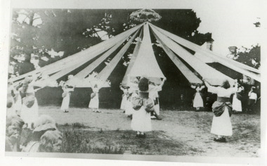
Photograph, Black & White x4 Maypole Dance Moorabbin State School 1922, 1922
In October 1872, State School 1111 Box Rise opened on the corner of Worthing Road and Dane Road. In order for this school to open, School No 442, a Wesleyan School, on the corner of Wickham Road and Chapel Lane, had to agree to close to meet pupil number requirements. Charles Sadgrove was head teacher of the new State School when it opened on October 1st 1872 and he remained until 1878. The school was renamed South Brighton in 1887 to accord with the nearby railway station which opened around that time. The main part of the present building dates from 1890. By the early 1900s the school had been extended to the north. . The school contains a plaque for Harry G Hawker, one of the pioneers of aviation, who attended the school in the closing years of the nineteenth century. The school was renamed Moorabbin in 1909.During the 1940s and 1950s population in the area surged and school enrolments peaked to over 800 under head teacher CS Lansell. Enrollments decreased to 470 in 1969. By the 1990s however, enrollments began to increase again. ( G Whitehead KCC Historian) Since 1890 Moorabbin Primary School No.1111 has been socially significant at a local level providing education for the families of the early settlers in Moorabbin ( South Brighton) Black & White photographs x 4 of pupils at Moorabbin State School Maypole Dancing c1922keys robert, marriott charles, gregg barriecity of moorabbin, county of bourke, moorabbin roads board, parish of moorabbin, shire of moorabbin, henry dendy's special survey 1841, were j.b.; bent thomas, o'shannassy john, king richard, charman stephen, highett william, ormond francis, maynard dennis, methodist church wickham road, box rise state school no.1111, methodist chapel cheltenham, education, early settlers -
 City of Moorabbin Historical Society (Operating the Box Cottage Museum)
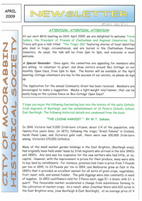
Newsletter, City of Moorabbin Historical Society Apr 2009, April 2009
The City of Moorabbin Historical Society was formed c 1960 by a group of Moorabbin residents who were concerned that the history of the area should be preserved. A good response to a call for items related to the historical area of Moorabbin Shire brought donations of a wide variety of artefacts which are now preserved by the current members of CMHS at Box Cottage Museum . Helen Stanley, Secretary of CMHS, began producing a Newsletter for members in April 2007 to provide current information and well researched items of historical interest.Helen Stanley has produced a bi-monthly Newsletter, 2007 - 2013, for the members of the City of Moorabbin Historical Society that contains well researched interesting historical items, notification of upcoming events, current advice from Royal Australian Historical Society , Museums Australia Victoria and activities of Local Historical Societies. The Newsletter is an important record of the activities of the CMHS.2 x A4 paper printed on 4 sides Issue 11 of the bi-monthly, City of Moorabbin Historical Society Newsletter produced by Society member and Secretary, Mrs Helen Stanley in April 2009. Notice that Mr Travis Sellars, Friends of Cheltenham and Regional Cemeteries, will talk about ‘The Tragic 20’s’ at the meeting April 26th . Volunteers are needed to show visitors around on Open Days each month and a Roster will be made on April 26th . Suggestions are requested for the Community Grant Application to be submitted by CMHS. Historical details are condensed from ‘ The Living Harvest’ by W.T Dobson, describing the establishment of St. Peter’s Catholic School East Bentleigh 1865 on land donated by Fred Quinn , in Centre Road, East Brighton ( East Bentleigh). A photo copy of Parts of Country Portion 39 of Dendy’s Special Survey or Brighton Estate showing the Land Sales of Lot 2, & 3 North Road and Jasper Road 1841 – 1869. Interesting note on the origin of ‘Jasper Road’. 3 photocopied photographs of St Peter’s School building 1903, School Children at East Brighton Railway Station, 1903, A Lorry in the parade 1903. CITY of MOORABBIN HISTORICAL SOCIETY / APRIL 2009 NEWSLETTERcity of moorabbin historical society, stanley helen, dobson w.t., melbourne, moorabbin, brighton, friends of cheltenham and reional cemeteries, cheltenham, ormond, bentleigh, market gardeners, irish immigrants c1850pioneers, early settlers, moorabbin shire, box cottage museum, port phillip bay, brighton estate, jasper road ormond, east boundary road brighton, dendy’s special survey 1851, point nepean road, south road brighton, thomas street brighton, north road brighton, county of bourke, box h., box william, parish of moorabbin, parish of prahran, markets, shingle roof, weather-board, mr., mckinnon, were jonathan, niall rev. fr. patrick, quinn fred, elsternwick, catholic church directory 1878, hibernian society melbourne, brady peter., kennedy mr., boland mr., leary mr., gahan mr., archbishop carr, rev. fr. gough., presentation convent gardenvale, sister mary vincent, charlston john, bavarian dress band, hales jasper -
 City of Moorabbin Historical Society (Operating the Box Cottage Museum)
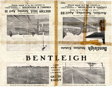
Flyer - Bentleigh Station Estate Auction, Coghill & Haughton - W.H. Wood, Bentleigh, c1914
... 50 Choice Building Blocks adjoining Bentleigh Railway... Auctions 50 Choice Building Blocks adjoining Bentleigh Railway ...One of the first sales in the district since the land boom which began in 1881when the train line to Mordialloc was built. The land boom came to a halt in the 1890's due to the depression. This sale was also successful as the electrification of the train line from the city to Frankston had been announced.Example of the progress of the Municipality of Moorabbin.Advertising flyer for auction of real estate sales - plan of building blocks for sale - pictures of local area50 Choice Building Blocks adjoining Bentleigh Railway Stationcentre road, mavho street, loranne street, burgess street, bentleigh, bentleigh railway station, real estate, auctions -
 City of Moorabbin Historical Society (Operating the Box Cottage Museum)
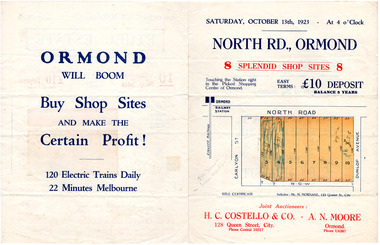
Flyer - North Road, Ormond - H. C. Costello & Co A. N. Moore, 1923
The train line from the city to Frankston was electrified which intensified the sale in the municipality of Moorabbin, particularly land which was in the vicinity of the railway stations.Example of the progress of the Municipality of MoorabbinAdvertising flyer for auction of real estate sales - plan of building blocks for shops for saleNorth Road, Ormond - 8 shop sitesnorth road, ormond, real estate, auctions -
 City of Moorabbin Historical Society (Operating the Box Cottage Museum)
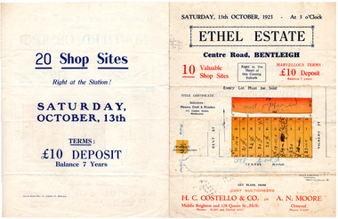
Flyer - Ethel Estate, Bentleigh - H. C. Costello & Co A. N. Moore, 1923
The train line from the city to Frankston was electrified which intensified the sale in the municipality of Moorabbin, particularly land which was in the vicinity of the railway stations.Example of the progress of the Municipality of MoorabbinAdvertising flyer for auction of real estate sales - plan of building blocks for saleEthel Estate, Centre Road Bentleigh 10 shop sites in Centre Roadcentre road, bentleigh, real estate, moorabbin, auction, shop sites -
 City of Moorabbin Historical Society (Operating the Box Cottage Museum)
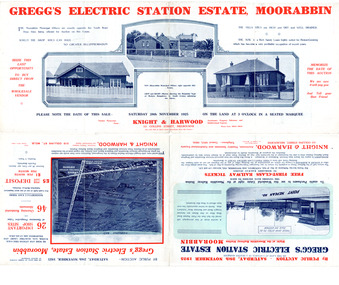
Flyer - Gregg's Electric Station Estate, Moorabbin, 1925
The train line from the city to Frankston was electrified which intensified the sale in the municipality of Moorabbin, particularly land which was in the vicinity of the railway stations.Example of the progress of the Municipality of MoorabbinAdvertising flyer for auction of real estate sales - plan of building blocks for saleGregg's Electric Station Estate, Moorabbin 26 business site and 46 home sites - Knight & Harwood pictures of local sites and buildingssouth road, barry street, south avenue, plym street, moorabbin, moorabbin station, gregg, real estate, auction -
 City of Moorabbin Historical Society (Operating the Box Cottage Museum)
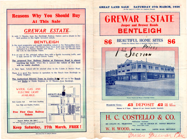
Flyer - Grewar Estate, Bentleigh, 1st Section Sold at Auction, 1926
The train line from the city to Frankston was electrified which intensified the sale in the municipality of Moorabbin, particularly land which was in the vicinity of the railway stations.Example of the progress of the Municipality of MoorabbinAdvertising flyer for auction of real estate sales - plan of building blocks for saleGrewar Estate Bentleigh - 86 Home Sites - H.C. Costello & W. H. Woodpatterson road, jasper road, bentleigh, real estate, auction, grewar -
 City of Moorabbin Historical Society (Operating the Box Cottage Museum)
Flyer - Grewar Estate, Bentleigh, 2nd Section Sold at Auction, 1926
The train line from the city to Frankston was electrified which intensified the sale in the municipality of Moorabbin, particularly land which was in the vicinity of the railway stations.Example of the progress of the Municipality of MoorabbinAdvertising flyer for auction of real estate sales - plan of building blocks for saleGrewar Estate Bentleigh - 73 Home Sites - H.C. Costello & W. H. Woodbentleigh, real estate, auction, grewar, mitchell street, daley street, brewer road -
 City of Moorabbin Historical Society (Operating the Box Cottage Museum)
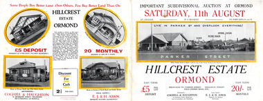
Flyer, 1928
The train line from the city to Frankston was electrified which intensified the sale in the municipality of Moorabbin, particularly land which was in the vicinity of the railway stations.Example of the progress of the Municipality of MoorabbinAdvertising flyer for auction of real estate sales - plan of building blocks for sale with pictures of local housesHillcrest Estate, Ormond - Auction Saturday 11August 1928arker street, holloway street, wild cherry road, ormond, real estate -
 City of Moorabbin Historical Society (Operating the Box Cottage Museum)
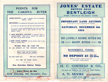
Flyer - Jones' Estate, Bentleigh, 1924
The train line from the city to Frankston was electrified which intensified the sale in the municipality of Moorabbin, particularly land which was in the vicinity of the railway stations.Example of the progress of the Municipality of MoorabbinAdvertising flyer for auction of real estate sales - plan of building blocks for saleJones' Estate, Brewer Road Bentleigh - 63 home sites & 19 business sites - H. C. Costello & Co - A. N. Moorepatterson road, brewer road, phillip street, north avenue, real estate, auction, bentleigh, moorabbin -
 City of Moorabbin Historical Society (Operating the Box Cottage Museum)
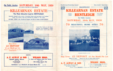
Flyer - Killearnan Estate, Bentleigh, 1930
The train line from the city to Frankston was electrified which intensified the sale in the municipality of Moorabbin, particularly land which was in the vicinity of the railway stations.Example of the progress of the Municipality of MoorabbinAdvertising flyer for auction of real estate sales - plan of building blocks for saleKillearnan Estate - 70 Homes Sites - Auction Saturday 10 May 1930thomas street, yawla street, huntley road, whitmuir road, bentleigh, whitmuir, killearnan, robert gray ford, mrs betsy armstrong, arthur crozier, real estate, auction, a. f. always & son, wilson bros., moorabbin, bentleigh club -
 City of Moorabbin Historical Society (Operating the Box Cottage Museum)
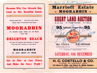
Flyer - Marriott Estate, Moorabbin, 1923
The train line from the city to Frankston was electrified which intensified the sale in the municipality of Moorabbin, particularly land which was in the vicinity of the railway stations.Example of the progress of the Municipality of MoorabbinAdvertising flyer for auction of real estate sales - plan of building blocks for saleMarriott Estate, Moorabbin Auction Saturday 8 December - 95 Splendid home sites - H. C. Costello & Comarriott, bentleigh, moorabbin, jasper road, mortimore street, fromer street, mckittrick street, real estate, auction -
 City of Moorabbin Historical Society (Operating the Box Cottage Museum)
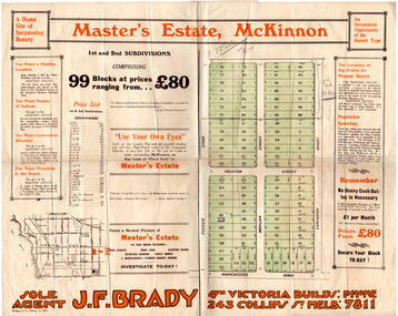
Flyer - Master's Estate, McKinnon
The end of WWI bought new interest in residential land. This sale must have been just before the electrification of the railway line from the city to Frankston which happened in 1922.Example of the progress of the Municipality of MoorabbinAdvertising flyer for auction of real estate sales - plan of building blocks for saleMaster's Estate, McKinnon - 99 Blocks - Agent: J. F. Bradymanchester road (now mckinnon road), tucker road, moylan street, lancaster street, preston street, real estate, bentleigh, mckinnon, moorabbin -
 City of Moorabbin Historical Society (Operating the Box Cottage Museum)
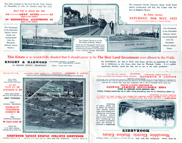
Flyer - Moorabbin Electric Station Estate, Moorabbin, 1925
The train line from the city to Frankston was electrified which intensified the sale in the municipality of Moorabbin, particularly land which was in the vicinity of the railway stations.Example of the progress of the Municipality of MoorabbinAdvertising flyer for auction of real estate sales - plan of building blocks for saleMoorabbin Electric Station Estate, Moorabbin - Auction Saturday 30 May 1925 - 65 Residential allotments Auctioneer Knight & Harwoodmoorabbin station, south road, station street, jasper street (now redholme street), central avenue, moorabbin, real estate, auction -
 City of Moorabbin Historical Society (Operating the Box Cottage Museum)
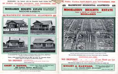
Flyer - Moorabbin Heights Estate, Moorabbin, 1928
The train line from the city to Frankston was electrified which intensified the sale in the municipality of Moorabbin, particularly land which was in the vicinity of the railway stations.Example of the progress of the Municipality of MoorabbinAdvertising flyer for auction of real estate sales - plan of building blocks for saleMoorabbin Heights Estate, Moorabbin - 48 residential allotments - Auction Saturday 24 November 1928moorabbin, bentleigh, east bentleigh, south road, tucker road, hinkler avenue, real estate, auction -
 City of Moorabbin Historical Society (Operating the Box Cottage Museum)
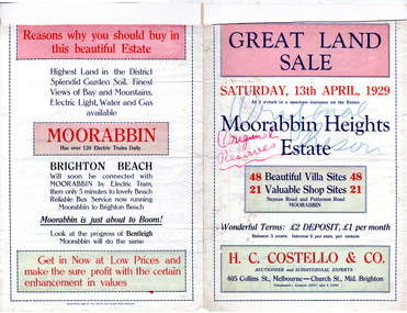
Flyer - Moorabbin Heights Estate, Moorabbin, 1929
The train line from the city to Frankston was electrified which intensified the sale in the municipality of Moorabbin, particularly land which was in the vicinity of the railway stations.Example of the progress of the Municipality of MoorabbinAdvertising flyer for auction of real estate sales - plan of building blocks for saleMoorabbin Heights Estate, Moorabbin 48 Villa sties, 21 Shop sites Sale on Saturday 13 April 1929 - H. C. Costello & CO.point nepean road (nepean highway), harding street, howell street, north avenue, coates street -
 City of Moorabbin Historical Society (Operating the Box Cottage Museum)
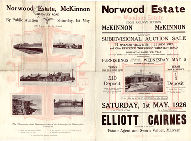
Flyer - Norwood Estate, McKinnon and Woodnor Estate, McKinnon, 1926
The train line from the city to Frankston was electrified which intensified the sale in the municipality of Moorabbin, particularly land which was in the vicinity of the railway stations.Example of the progress of the Municipality of MoorabbinAdvertising flyer for auction of real estate sales - plan of building blocks for saleNorwood and Woodnor Estate, McKinnon 31 Villa Site & 11 Shop sites - Auction Saturday 1 May - Auctioner Elliott Cairnesmckinnon, norwood, wheatley road, jean street, anne street, lysbeth street, mckinnon road, jasper road, real estate, auction -
 City of Moorabbin Historical Society (Operating the Box Cottage Museum)
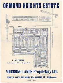
Flyer - Ormond Heights, East Bentleigh
The train line from the city to Frankston was electrified which intensified the sale in the municipality of Moorabbin, particularly land which was in the vicinity of the railway stations.Example of the progress of the Municipality of MoorabbinAdvertising flyer for auction of real estate sales - plan of building blocks for salenorth road, moulden street, george street, garden road, bruce street (now bethwyn street), boundary road (now east boundary road), murrong avenue, bay view street, rochford street, mitchell street, lancaster street, east bentleigh, real estate -
 City of Moorabbin Historical Society (Operating the Box Cottage Museum)
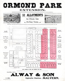
Flyer - Ormond Park Extension, Ormond, 1924
The train line from the city to Frankston was electrified which intensified the sale in the municipality of Moorabbin, particularly land which was in the vicinity of the railway stations.Example of the progress of the Municipality of MoorabbinAdvertising flyer for auction of real estate sales - plan of building blocks for saleOrmond Park Extension - 32 Allotment for Private Sale - Alway & Sonmanchester road (now mckinnon road), lindsay street, hall street, ormond, real estate -
 City of Moorabbin Historical Society (Operating the Box Cottage Museum)
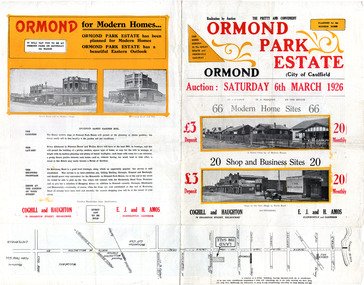
Flyer - Ormond Park Estate, Ormond, 1926
The train line from the city to Frankston was electrified which intensified the sale in the municipality of Moorabbin, particularly land which was in the vicinity of the railway stations.Example of the progress of the Municipality of MoorabbinAdvertising flyer for auction of real estate sales - plan of building blocks for saleOrmond Park Estate - 66 Home Sites and 20 shop and business sites - Coghill and Haughtonormond, real estate, koornang road, wallen grove, florence street, auction -
 City of Moorabbin Historical Society (Operating the Box Cottage Museum)
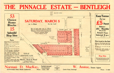
Flyer - Pinnacle Estate, Benteligh, 1927
The train line from the city to Frankston was electrified in 1922 which intensified the sale in the municipality of Moorabbin, particularly land which was in the vicinity of the railway stations.Example of the progress of the Municipality of MoorabbinAdvertising flyer for auction of real estate sales - plan of building blocks for saleThe Pinnacle Estate, Bentleigh - 53 Home sites & 15 Shop Sites - Auction Saturday March 5, 1927 - Norman D. MacKay and W. Ansteepatterson road, pt. nepean road (now nepean highway), vunabere ave, galtum ave, tovan-akas ave, patterson, bentleigh, auction, real estate -
 City of Moorabbin Historical Society (Operating the Box Cottage Museum)
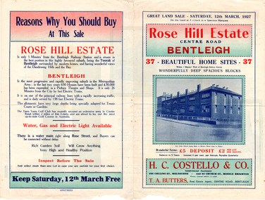
Flyer - Rose Hill Estate, 1927
The train line from the city to Frankston was electrified in 1922 which intensified the sale in the municipality of Moorabbin, particularly land which was in the vicinity of the railway stations.Example of the progress of the Municipality of MoorabbinAdvertising flyer for auction of real estate sales - plan of building blocks for saleRose Hill Estate, Bentleigh - 37 home sites - Auction Saturday 12 March 1927 - H. C. Costello & Cocentre road, rose street, real esate, auction, bentleigh -
 City of Moorabbin Historical Society (Operating the Box Cottage Museum)
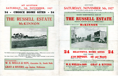
Flyer - Russell Estate, McKinnon
The train line from the city to Frankston was electrified in 1922 which intensified the sale in the municipality of Moorabbin, particularly land which was in the vicinity of the railway stations.Example of the progress of the Municipality of MoorabbinAdvertising flyer for auction of real estate sales - plan of building blocks for saleRussell Estate, McKinnon - 24 home sites - Auction 5 November 1927 - W.E. Wells and Sons, Gray and Riversmckinnon road, thomas street, hopkins street, mckinnon, real estate, auction