Showing 1520 items matching " sand"
-
 Bendigo Military Museum
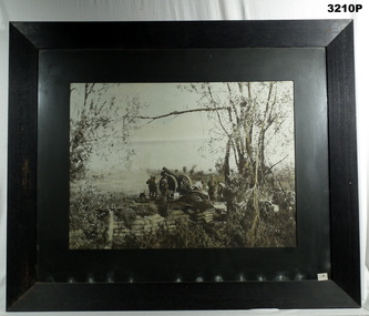
Photograph - PHOTOGRAPH WW1, FRAMED, Golarts Studios, Post WW1
Photo of Artillery Battery Gun Emplacement. Field gun supported with sand bag wall. Gun crew preparing site for action. Black & white photo mounted in black wooden frame with black border, cardboard backing, glass front. Front RHS bottom & back, LHS bottom: “No 53 stickers” Back LHS bottom: “Trust No 22”photography-photographs, frame accessories, military history, arms-ordnance, passchendaele barracks trust -
 Bendigo Military Museum
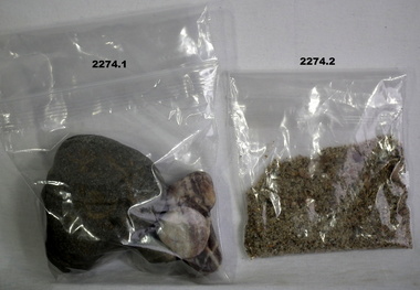
Souvenir - SOUVENIRS, ANZAC COVE, Post 1990
.1) Four rocks of various size from the beach on Anzac Cove .2) Sand from the beach at Anzac Cove .3) Cone from an aleppo pine grown on Gallipoli .4) Small round pine cone from Gallipolianzac, pines, minerals, souvenirs -
 Mission to Seafarers Victoria
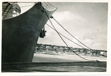
Photograph, M/S "Mongabarra" Goteborg, Tied up at Port Lincoln, April 1950
This series of photographs captures life at sea and the conditions on the ship M/S "Mongabarra" Goteborg in 1950.This photograph is part of the Allan Quinn collection, which is a pictorial autobiography, and it represents one of many moments of his time abroad as a seafarer.Black and white photograph of the M/S "Mongabarra" Goteborg tied up at Port Lincoln in April 1950. The ship is situated on the left-hand side of the photograph with ropes dug into the sand on the right-hand side of the photograph with Port Lincoln in the background.m.s. mongabarra, port lincoln, goteborg -
 Bendigo Historical Society Inc.
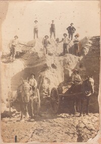
Photograph - WORKERS ON OLD TOM SANDHEAP
Sepia toned photograph of Workers on Old Tom 'Sand heap O'Halloran's Team' Markings on photo read 'A. Levy & co' Within the photo are 2 horses and carts as well as 9 male workers. Old Tom Mine in Whipstick, Eaglehawk.A Levy & Coperson, group, group of workers, old tom sand heap, mining, workmen, horse and buggies, o'halleran's team -
 Lakes Entrance Historical Society
Photograph, Eastwood Bros, 1889c
Sepia photograph showing the just opened Entrance to Bass Strait. Sand not completely cleared from channel, buildings on dunes, dredge Wombat moored off Bullock Island. Rock groynes being built in lake. Lakes Entrance Victoriawaterways, islands, jetties, houses -
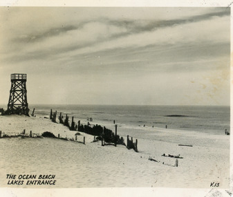 Lakes Entrance Historical Society
Postcard - Ocean Beach, 1950c
Black and white small format postcard of the ocean beach. It shows an expanse of sand dune, remains of a brush windbreak fence, and the observation tower, built for Royal Lifesaving Club, pre Surf Life Saving Club. Lakes Entrance VictoriaThe Ocean Beach Lakes Entrancebeaches, surf lifesaving -
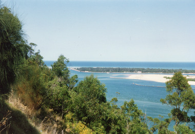 Lakes Entrance Historical Society
Photograph - The Entrance, 1992c
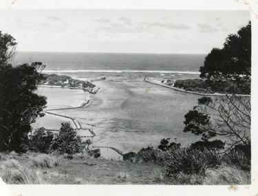
Colour photograph of the western side of the Entrance. It shows scrub covered hummocks, dredged sand dumped at Snake Island, rock groynes from island to lake, taken from lower side of highway at Jemmys Point. Lakes Entrance Victoriaislands, topography, waterways -
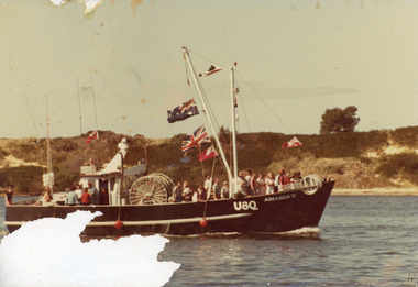 Lakes Entrance Historical Society
Photograph - Amanda N, 1980
Colour photograph of the fishing boat Amanda N in Cunninghame Arm, shows about 25 people on deck, flags flying as if for a celebration, sand hummocks in background have low vegetation, only one tree visible. Lakes Entrance Victoriaboats and boating, fishing industry -
 Lakes Entrance Historical Society
Photograph - Bullock Island, Silver Reflections Studio, 1920c
Black and white photograph showing Bullock Island, Entrance to Bass Strait, buildings on sand dunes, yacht sailing on Cunninghame Arm, tourist launch in foreground, rock groynes around west end of Bullock Island. Lakes Entrance Victoriawaterways, room display, islands -
 National Vietnam Veterans Museum (NVVM)
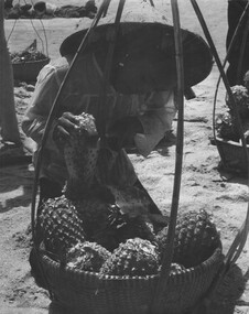
Photograph, Gibbons, Denis, Pineapples
Denis Gibbons (1937 – 2011) Trained with the Australian Army, before travelling to Vietnam in January 1966, Denis stayed with the 1st Australian Task Force in Nui Dat working as a photographer. For almost five years Gibbons toured with nine Australian infantry battalions, posting compelling war images from within many combat zones before being flown out in late November 1970 after sustaining injuries. The images held within the National Vietnam Veterans Museum make up the Gibbons Collection..A black and white photograph of a young Vietnamese girl prepares a pineapple for a serviceman on the sand at Back Beach, Vung Tau. The young girls carried two large baskets, on a pile of pineapples, which were very heavy for such a small slip of a girl.photograph, back beach, vung tau, vietnamese children, gibbons collection catalogue, denis gibbons, photographer, vietnam war -
 Bendigo Historical Society Inc.
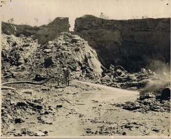
Photograph - PHOTOGRAPH OF DEVONSHIRE DUMPS 1954
Black and white photo attached to board. Image shows Devonshire sand dumps, man standing in centre holding a large hose, squirting water at the surface of the dump. High walls of dump behind. On back " Devonshire Dumps Sluicing 1951"gold mines, mining equipment, devonshire sand dump -
 Lakes Entrance Historical Society
Photograph - Sand hummocks Lakes Entrance c1950
Black and white photograph taken from the sand hummocks looking across Cunninghame Arm waterway to jetties and buildings along Esplanade Lakes Entrance c1950 . Also three photographs taken from similar location looking over waterway waterways, vegetation, houses, township -
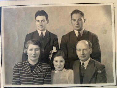
 Kadimah Jewish Cultural Centre and National Library
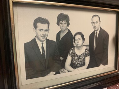
Photograph - Scanned Photograph: Bezalel (Zal) Markov's family
A portrait of Bezalel (Zal) Markov with his family, including daughter Lois Sandor. Markov was President of the Kadimah in 1918.kadimah jewish cultural centre, z. markov, bezalel markov, lois sandor, kadimah presidents -
 Kadimah Jewish Cultural Centre and National Library
Photograph - Bezalel (Zal) Markov's family
A portrait of Bezalel (Zal) Markov with his family, including daughter Lois Sandor. Markov was President of the Kadimah in 1918.kadimah jewish cultural centre, z. markov, bezalel markov, lois sandor, kadimah presidents -
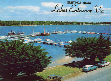 Lakes Entrance Historical Society
Postcard - Lakes Entrance, The Rose Series, 1975
Sand dumping has commenced in preparation of works to modify and deepen Cunninghame Arm|Also one other copyColour postcard of the view of Cunninghame Arm, Lakes Entrance, from the Glenara Tower. Shows the western boat harbour with private cruisers and professional fishing vessels moored at wharf. Lakes Entrance Victoriawaterways, boats and boating, jetties, waterfront -
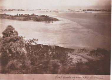 Lakes Entrance Historical Society
Photograph - New Works Lakes Entrance, 1885 c
Shows sand between timber piers at Entrance site, vegetation on Bullock Island, vegetation on hummocks is very sparse.Sepia toned photograph of New Works area prior to opening Lakes Entrance VictoriaGovernment Works at new Lakes Entrancesettlement, houses, waterways, gippsland lakes -
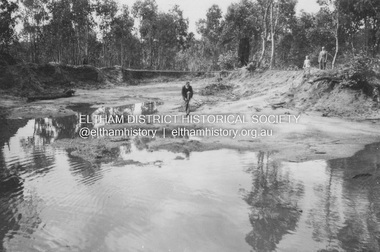
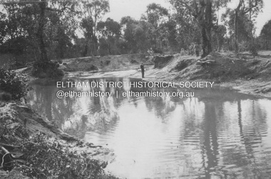 Eltham District Historical Society Inc
Album - Photograph, J.A. McDonald, General; Lorimer Road, Wattle Glen, Feb. 1956
21st October 1953 Sand pits off the Orme Road Gully running between Reynolds Road and Lorrimer RoadRecord of various Shire of Eltham infrastructure works undertaken during the period of 1952-1962 involving bridge and road reconstruction projects, sometimes with Eltham Shire Council Project Reference numbers quoted. It was during this period that a number of significant improvements were made to roads and new bridges constructed within the shire that remain in place as of present day (2022). In many situations, the photos provide a tangible visible record of infrastructure that existed throughout the early days of the Shire. The album was put together by or under the direction of the Shire Engineer, J.A. McDonald.infrastructure, shire of eltham, 1953-10-21, bridge construction, lorimer road, road construction, wattle glen -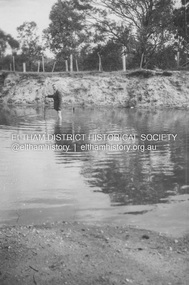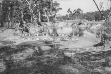
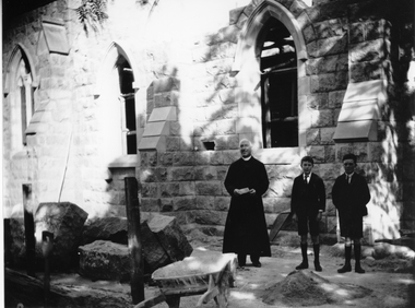 Stawell Historical Society Inc
Photograph, St. Patrick’s Church Sanctuary under construction with the priest and two boys watching
St. Patrick’s Church Sanctuary under construction with priest and two boys standing near workman's barrow and pile of sand.stawell religion -
 Port Fairy Historical Society Museum and Archives
Photograph
The Dredge 'Pioneer' brought in to clear sand drift from the Moyne river caused by the South West passage sweeping throughBlack and white photograph of a dredge in Moyne riversea, river, moyne river, south west passage, pioneer, deredge, ship -
 Bendigo Military Museum
Photograph - PHOTOGRAPHS, 1939-45
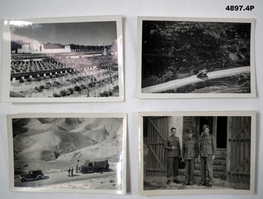
Albert Edward Corrie VX47191, 6th Div Postal Unit.1. Black & White Photograph - Cemetery, Memorial, Headstones. 2. Black & White Photograph - Truck on Road 3. Black & White Photograph - Sand Hils, vehicles and 3 men on road, 4. Black & White Photograph - 3 uniformed soldiers.1. War Cemetery Jerusalem. 2. On the road to the Dead Sea. 3. Some of the hills on the road to the Dead Sea. 4. Hec McKinnon, CAPRT Cohen, Kirk White.photographs, ww2, postal unit -
Glenelg Shire Council Cultural Collection
Photograph - Photograph - Lee Breakwater, Portland, n.d
Port of Portland Authority Archivesport of portland archives, henty beach, construction, fishermans breakwater, raft, marine, maritime -
Clunes Museum
Tool - GOLD CRADLE & PANNING DISH, JAMES ESMOND, CIRCA 1850
USED TO OBTAIN ALLUVIAL GOLD THE DESIGN OF THIS EQUIPMENT IS MOSTLY BASED ON THE PRINCIPLE OF THE WAY HEAVY MINERALS ARE CONCENTRATED IN ALLUVIAL DEPOSITS. THE PROSPECTING DISH IS USED WHEN WORKING WITH SMALL AMOUNTS OF STONES & CLAY WHILE BIGGER JOBS THE CRADLE OR BANJO IS MORE EFFICIENT. THE GAUZE OF MESH IN THE SIEVE IS VARIABLE. THE CRADLE OR BANJO IS USUALLY SET UP AT RIGHT ANGLES TO A SHALLOW CREEK OR WATERHOLE WITH THE OPEN ENDS TOWARDS THE WATER.1 WOODEN CONSTRUCTION MADE BY HAND WITH GAUZE FILTER IN UPPER SECTION TO SEPARATE QUARTZ ROCKS, SAND AND SOIL. A HANDLE ON BOX LIKE CONSTRUCTION IS USED TO ROCK THE CRADLE WHICH IS MOUNTED WITH ITS ROCKERS RESTING ON WOODEN BEARERS. .2 PANlocal history, mining equipment, mining -
 Queen Victoria Women's Centre
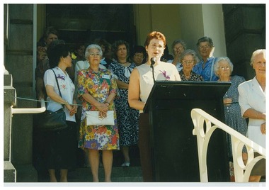
Photograph, 15th or 16th February 1997
Colour photograph. Janet England, Chair of Trust, standing behind a lectern on the front steps of the QVWC building during the grand opening weekend. Several people are sanding behind J.E. Marion Lau left of frame. Jane Wade Right of frame. official events, historic buildings, cultural structures and establishments -
 Lakes Entrance Historical Society
Photograph - The Entrance, 1930c
Black and white photograph showing wooden piers at entrance to Bass Strait from the Gippsland Lakes. Buildings on sand dunes, Bullock Island and rock groynes. Photo taken from Jemmys Point showing shrubbery in foreground. Lakes Entrance Victoriawaterways, topography, boats and boating, islands -
 Lakes Entrance Historical Society
Photograph - Lakes Entrance, 1935c
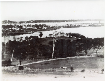
Enlarged from postcard produced for Mrs Allen to advertise Allen's Tearoom at the brow of Myer St hill, known as Allen's Hill to locals.|This is the paired before photograph showing the left hand side on Butchers paddock in the panoramic views, the right hand side number 01715. This photograph used in the 150 year Lakes Entrance 1858-2008 display.Black and white photograph of the township, taken from Allen's Hill, Myer St. It shows the town between Cunninghame Arm and North Arm, cleared and fenced paddocks in foreground, New Works village and sand hummocks in distance. Lakes Entrance Victoria township, waterways, topography -
 Lakes Entrance Historical Society
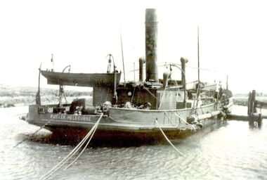
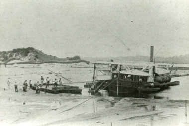
Photograph - Wombat, 1885c
The dredge 'Wombat' owned by John Carpenter, contractor for stage one of cutting the entrance from the lake through to ocean - Bass Strait. Photo shows channel partly dredged and men on work platform in front of dredge.Black and white photograph showing bucket dredge Wombat removing sand from between piers. Dunes on western side on left, lakes in background, hills of Kalimna and Nungurner in distance. Work platform in front of dredge with workers. Lakes Entrance Victoria waterways, public works, dredging -
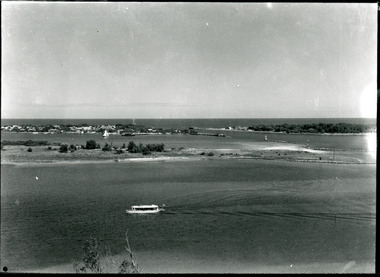
 Lakes Entrance Historical Society
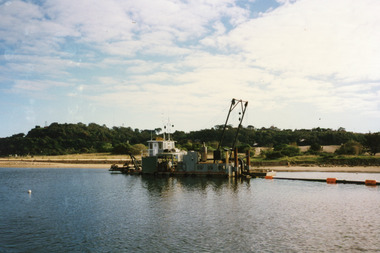
Photograph - Dredging, 1998
Color photograph of Bullock Island. It shows the dredge Sandpiper working in Cunninghame Arm on the southern shore of Bullock Island. Dredged sand in background on island from previous dredging operations, Kalimna Heights and Jemmys Point in the background. Lakes Entrance Victoriaislands, waterways, public works, dredging