Showing 4042 items
matching surveying
-
 Bendigo Military Museum
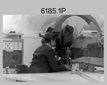
Photograph - Capturing Topographic Features with a Wild B8 – Army Survey Regiment, Fortuna, Bendigo, c1980
These four photographs of SPR Santina (Argetto) Straube capturing topographic features – plotting with a Wild B8 stereo plotter were most likely taken in c1980. Introduced in 1966, the Wild B8 stereo plotter was used for plotting topographic detail and contours. These analogue machines were manually controlled by adjusting the control knobs for the orientation of the 3D image. The B8s used a nine-inch square photo image on a film or glass diapositive which allowed highly accurate extraction of map features. At first, plotting by B8 and B9 equipment was undertaken at the aerial photography scale of 1:80,000 in pencil onto a controlled plotting sheet. Sheets were then inked up and reduced photographically to the 1: 100,000 publication scale for scribe impression production. In these photos SPR Santina (Argetto) Straube was plotting with a pencil or ink pen mounted at the far end of the pantograph arm. The plotting procedure was upgraded to direct plotting in ink with photographic reduction to publication scale. In 1975 four B8s were upgraded with tri-axis locaters as part of the Input Sub-system to enable digital extraction to AUTOMAP 1’s topographic database. When AUTOMAP 2 was introduced in 1982 these B8s were upgraded, and additional machines added to expand the Army Survey Regiment’s digital capture capability. This is a set of four photographs of a technician capturing topographic Features with a Wild B8 stereo plotter in Air Survey Squadron – Army Survey Regiment, Fortuna, Bendigo. 1980. The photographs were on 35mm negative film and were scanned at 96 dpi. They are part of the Army Survey Regiment’s Collection. .1) to .4) Photo, black & white, c1980. SPR Santina (Argetto) Straube operating a Wild B8 stereo plotter..1P to .4P – no annotations.royal australian survey corps, rasvy, army survey regiment, army svy regt, fortuna, asr, air survey, photogrammetry -
 Bendigo Military Museum
Photograph - 4th Field Survey Squadron – Operation MIZMAZE 92, Kimberley region, Western Australia, 1992
This is a set of 40 photographs taken in 1992 during 4th Field Survey Squadron’s deployment on Operation MIZMAZE 92 in the Kimberley region of Western Australia from the 13th of May to the 14th of July 1992. The area of operations was Wyndham, Halls Creek and Sandfire Flat. It was a two-part operation involving the field completion of topographic maps and the acquisition of mapping control by GPS field parties utilising Texas Instruments TI4100 Global Positioning System receivers. Survey parties conducted field checking of topographic maps and GPS control acquisition in Perentie 110 Series Survey variant FFR Land Rovers. Three Bell Kiowa LOH helicopters provided by 162 Recce Sqn supported field checking and limited deployment of GPS surveys parties. C-l30 Hercules from 36 Sqn supported deployment and extraction of personnel and equipment to and from from the AO. A Cessna 404 Titan Ambassador from Vee-H Aviation was used as the Wild RC10 camera platform for aerial photography acquisition.This is a set of 40 photographs taken in 1992 during 4th Field Survey Squadron’s deployment on Operation MIZMAZE 92 in the Kimberley region of Western Australia. The colour photographs are on 35mm negative film and are part of the Army Survey Regiment’s Collection. The photographs were scanned at 96 dpi. .1) - Photo, colour, 1992. CAPT Craig Hersant. .2) - Photo, colour, 1992. Unidentified officer/soldier. .3) & .4) - Photo, colour, 1992. Aboriginal rock art - Wandjina Gunduran, Donkey Creek. .5) - Photo, colour, 1992. Aboriginal rock art - Track Wandjinas, Donkey Creek. .6) & .7) - Photo, colour, 1992. CAPT Craig Hersant. .8) - Photo, colour, 1992. Kimberley region topography. CPL Glen Weatherell. .9) - Photo, colour, 1992. Unidentified personnel .10) - Photo, colour, 1992. Supermarket at unknown location. .11) to .13) - Photo, colour, 1992. Caravan park at unknown location. .14) - Photo, colour, 1992. Old bridge at Fitzroy Crosssing. .15) & .16) - Photo, colour, 1992. Survey party in Perentie 110 Series Land Rover. .17) & .18) - Photo, colour, 1992. Kimberley region topography. .19) - Photo, colour, 1992. Kimberley region topography. CPL Glen Weatherell. .20) - Photo, colour, 1992. Kimberley region topography, possibly the Bungle Bungles. .21) - Photo, colour, 1992. Kimberley region topography. SGT Frank Downie. .22) - Photo, colour, 1992. Kimberley region topography: the Bungle Bungles. .23) - Photo, colour, 1992. Kimberley region topography: the Bungle Bungles. .24) - Photo, colour, 1992. Kimberley region topography: the Bungle Bungles. SPR Neil Pedler. .25) & .26) - Photo, colour, 1992. Kimberley region topography: the Bungle Bungles. .27) - Photo, colour, 1992. Kimberley region topography. .28) - Photo, colour, 1992. Survey party with Perentie 110 Series Land Rover. .29) - Photo, colour, 1992. Kimberley region topography. .30) - Photo, colour, 1992. Survey party outside Perentie 110 Series Land Rover. .31) & .32) - Photo, colour, 1992. Survey party operating TI4100 GPS Receiver next to Perentie 110 Series Land Rover. SGT Eddie Jacobs. .33) & .34) - Photo, colour, 1992. Survey party operating TI4100 GPS Receiver next to Perentie 110 Series Land Rover. Unidentified surveyor. .35) - Photo, colour, 1992. Kimberley region topography. Hand water pump at well. .36) - Photo, colour, 1992. Survey party in Perentie 110 Series Land Rover. .37) - Photo, colour, 1992. Kimberley region topography. CPL Glen Weatherell. .38) - Photo, colour, 1992. Kimberley region topography viewed from Bell Kiowa LOH helicopter. .39) & .40) - Photo, colour, 1992. Unidentified surveyor field checking a preliminary map in a Bell Kiowa LOH helicopter..1P to .40P – There are no personnel identified. ‘1992 OP MIZMAZE annotated on negative sleeve.royal australian survey corps, rasvy, 4 fd svy sqn, op mizmaze 92 -
 Bendigo Military Museum
Photograph - Various Photos - Army Headquarters Survey Regiment, Fortuna, Bendigo, c1950s to 1960s
This is a collection of five photographs taken at the Army Headquarters Survey Regiment, Fortuna Villa, Bendigo, circa 1950s to 1960s. Appearing in photo .3P is MAJ Edward Anderson MBE, who served from 1942 to 1977 and reached the rank of LTCOL. LT Frank Thorogood SB St J. served from 1960 to 1981. He reached the rank of LTCOL and was the CO of the Army Survey Regiment from 1980 to 1981. CAPT W. Greer’s service history is unknown. Appearing in photo .5P is MAJ Nolan, who served from 1939 to 1975. He was promoted to LTCOL and was the CO of the Army Headquarters Survey Regiment from 1965 to 1969. He was subsequently promoted to COL and was the Director of Military Survey from 1972 to 1975.This is a collection of five photographs taken at the Army Headquarters Survey Regiment, Fortuna Villa, Bendigo, circa 1950s to 1960s. The photographs were printed on photographic paper and are part of the Army Survey Regiment’s Collection. They were scanned at 300 dpi. .1) - Photo, black and white, 1950s. Regiment briefings by Fortuna’s lake. .2) - Photo, black and white, 1960s. Unidentified officer and civilian visitors in the Officers Mess. .3) - Photo, black and white, 1960s. L to R: MAJ Edward Anderson MBE, CAPT W. Greer and LT Frank Thorogood SB St J; in the Officers Mess. .4) - Photo, black and white, 1962. Regiment parade held in Fortuna’s grounds where the tennis and basketball courts were later developed. .5) - Photo, black and white, 1960s. MAJ John Nolan (centre) with unidentified civilian visitors.Personnel were identified in photos .3P and .5P. The date is annotated on photo .4P.royal australian survey corps, rasvy, army survey regiment, army svy regt, fortuna, asr -
 Waverley RSL Sub Branch
Print Gentlemen The Queen, Gentlemen The Queen
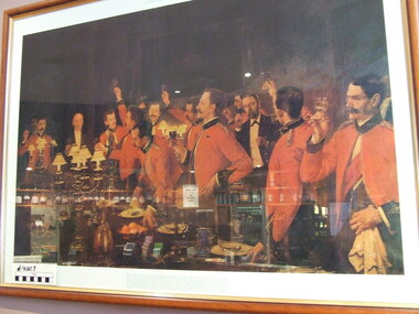
Original Painting in Bendigo Art Gallery PAINTING WON'T HANG IN MESS BENDIGO intends to keep its big oil painting, "Gentlemen - the Queen," hanging in the Shamrock Hotel in Pall Mall. i The painting is on loan to the hotel from the Bendigo Art Gallery. And It's badly wanted at the officers' mess of the Royal Australian Artillery, 3rd Div., in Batman av., Melbourne. A formal application for It was made, In writing, to the Art Gallery by Brigadier W. Hall, commanding offlfncer. But Art Gallery members at their meeting yesterday said "No." Lending it or giving it away would "create a dan- gerous precedent for the Gallery," they decided. . "Any anyway," said Mr. W. Little, the Gallery's curator, "Brig. Hall has erred in thinking the men depicted in the painting are artillerymen. "They're offlfflcers In the Duke of Connaught's Light Infantry." But in Melbourne last night Brigadier Hall, keenly disappointed, said: VI have been told the picture was painted in the Royal Artil- lery mess at Woolwich, In England. "I have never dauhted the men are artillerymen, be- cause they wear the gun- ners' blue mess Jacket, scar- let cuffs and scarlet waist- coat." The Argus Tuesday 8 September 1953 Digitalised http://trove.nla.gov.au/ndp/del/article/23307813/1762840?zoomLevel=3Colour print of a painting by Albert Chevallier Taylor in wooden frame Glass frontedCopy by Survey Regiment 1986gentlemen the queen, argus newspaper, bendigo art gallery. -
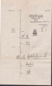
 Bendigo Historical Society Inc.
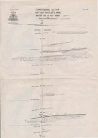
Map - STRUGNELL COLLECTION: HUSTLER'S LINE OF REEFS, BENDIGO, September 1913
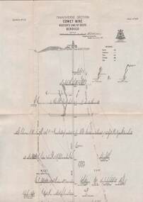
Map, Hustler's Line of Reefs, Comet Mine, Transverse Section, Plate No.XXV (25). Bulletin No 33 Signed H.A.Whitelaw. Drawing shows the vertical shaft descending to over 1692 feet and appears to show samples of connecting horizontal shafts with their respective mineral contentsUnderground Survey Office, Bendigo.map, bendigo, comet mine -
 Bendigo Historical Society Inc.
Map - STRUGNELL COLLECTION: HUSTLER'S LINE OF REEFS, BENDIGO, September 1913
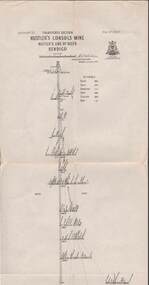
Map, Hustler's Line of Reefs, Hustler's Reef Mine, East & West Cross-Cuts, North & South of Shaft. Plate No. X1X (19).Bulletin No 33 Signed H.A.Whitelaw. Drawing shows the vertical shaft descending to over 1296 feet and appears to show samples of connecting horizontal shafts with their respective mineral contentsUnderground Survey Office, Bendigo.map, bendigo, hustler's reef mine -
 Bendigo Historical Society Inc.
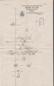
Map - STRUGNELL COLLECTION: HUSTLER'S LINE OF REEFS, BENDIGO, September 1913
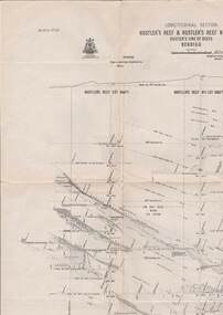
Map, Hustler's Line of Reefs, Fortuna Hustler's Mine, Bendigo, Transverse Section. Plate Mo.111(3).Bulletin No 33 Signed H.A.Whitelaw. Drawing shows the vertical shaft descending to over 2228 feet and appears to show samples of connecting horizontal shafts with their respective mineral contentsUnderground Survey Office, Bendigo.map, bendigo, fortuna hustler's mine -
 Bendigo Historical Society Inc.
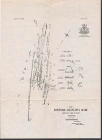
Map - STRUGNELL COLLECTION: HUSTLER'S LINE OF REEFS, BENDIGO, September 1913
Map, Hustler's Line of Reefs, Fortuna Hustler's Mine, Plan, Plate No.11(2).Bulletin No 33 Signed H.A.Whitelaw.Underground Survey Office, Bendigo.map, bendigo, fortuna hustler's mine -
 Bendigo Historical Society Inc.
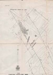
Map - STRUGNELL COLLECTION: HUSTLER'S LINE OF REEFS, BENDIGO, September 1913
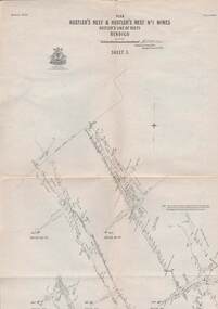
Map, Hustler's Line of Reefs, Bendigo, Plan Fortuna Hustler's Mine, Hustler's Royal Reserve No. 2 Lease. Plate No.1(1) Bulletin No 33 Signed H.A.Whitelaw.Underground Survey Office, Bendigo.map, bendigo, fortuna hustler's mine -
 Bendigo Historical Society Inc.
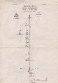
Map - STRUGNELL COLLECTION: HUSTLER'S LINE OF REEF, BENDIGO
Map, Hustler's Line of Reef, Bendigo, Fortuna Hustler's Mine, Longitudinal Section. Plate No. 1V (4). NOTE--- Plates 4,8,13,29,26 & 31 form a Longitudinal Section from Fortuna Hustler's to Hustler's Consols Mine.Bulletin No 33 Signed H.A.Whitelaw. Drawing shows the vertical shaft descending to over 2228 feetUnderground Survey Office, Bendigo.map, bendigo, fortuna hustler's mine -
 Bendigo Historical Society Inc.
Map - STRUGNELL COLLECTION: HUSTLER'S LINE OF REEFS, September 1913
Map, Hustler's Line of Reefs, Hustler's Consols Mine, Transverse Section, Bendigo.Plate no. XXX111 (33).Bulletin No 33 Signed H.A.Whitelaw. Drawing shows the vertical shaft descending to over 1326 feet and appears to show samples of connecting horizontal shafts with their respective mineral contentsUnderground Survey Office, Bendigo.map, bendigo, hustler's consols mine -
 Bendigo Historical Society Inc.
Map - HUSTLER'S LINE OF REEFS, September 1913
Map, Hustler's Line of Reefs, Hustler's Reef & Hustler's Reef No. ! Mines, Bendigo, Longitudinal Section,Plate No.XX (20). NOTE-- Plates 4,8,13,20,26 & 31 form a Logitudinal Section from Fortuna Hustler's to Hustler's Consols Mine.Bulletin No 33 Signed H.A.Whitelaw. Drawing shows the vertical shaft descending to over 1601 feetUnderground Survey Office, Bendigo,map, bendigo, hustler's reef & hustler's reef 1 -
 Bendigo Historical Society Inc.
Map - STRUGNELL COLLECTION: HUSTLER'S LINE OF REEFS, September 1913
Map, Hustler's Line of Reefs, Hustler's Reef & Hustler's Reef No1 Mines Plan, Bendigo.Plate No. XV11 (17).Bulletin No 33 Signed H.A.Whitelaw.Underground Survey Office, Bendigo.map, bendigo, hustler's reef & hustler's reef 1 -
 Bendigo Historical Society Inc.
Map - STRUGNELL COLLECTION: HUSTLER'S LINE OF REEFS, September 1913
Map, Hustler's Line of Reefs, Hustler's Reef Mine, Transverse Section, Bendigo. Plate No. XV111 (18).Bulletin No 33 Signed, H.A.Whitelaw. Drawing shows the vertical shaft descending to over 2195 feet and appears to show samples of connecting horizontal shafts with their respective mineral contentsUnderground Survey Office, Bendigo.map, bendigo, hustler's reef mine -
 Bendigo Historical Society Inc.
Map - STRUGNELL COLLECTION: HUSTLER'S LINE OF REEF'S. HUSTLER'S REEF NO.1 MINE, September 1913
Map, Hustler's Line of Reefs, Hustler's Reef No. 1, Bendigo, East & West Cross-cuts, North & South of Shaft, Plate No.XX11 (22). Bulletin No 33 Signed H.A.Whitelaw. Drawing shows the vertical shaft descending to over 1229 feet and appears to show samples of connecting horizontal shafts with their respective mineral contentsUnderground Survey Office, Bendigo.map, bendigo, hustler's reef no.1 mine -
 Bendigo Historical Society Inc.
Map - STRUGNELL COLLECTION: HUSTLER'S LINE OF REEF, September 1913
Map, Hustler's Line of Reefs, Hustler's Reef & Hustler's Reef No.1 Mines Bendigo.Plate No. X1V (14) Comet Co. .Bulletin No 33 Signed H.A.Whitelaw. Drawing shows reef boundary lines .There is an explanatory box showing depth in feet and inches of the mines .Underground Survey Office, Bendigo.map, bendigo, hustler's reef & hustler's reef 1 -
 Bendigo Historical Society Inc.
Map - STRUGNELL COLLECTION: HUSTLER'S LINE OF REEFS, September 1913
Map, Hustler's Line of Reefs, Hustler's Reef No.1 Mine Bendigo, Transverse Section.Plate No. XX1 (21).Bulletin No 33 Signed H.A.Whitelaw. Drawing shows the vertical shaft descending to over 1428 feet and appears to show samples of connecting horizontal shafts with their respective mineral contentsUnderground Survey Office, Bendigo.map, bendigo, hustler's reef no.1 mine -
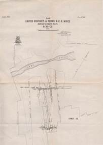
 Bendigo Historical Society Inc.
Map - STRUGNELL COLLECTION: UNITED HUSTLER'S & REDAN MINE, September 1913
Map, Transverse Sections N. & S. Of shaft, United Hustler's & Redan Mine, Hustler's Line of Reef, Bendigo. Plate No. XXX (30).Bulletin No 33 Signed H.A.Whitelaw. Drawing shows the vertical shaft descending to over 976 feet and appears to show samples of connecting horizontal shafts with their respective mineral contentsUnderground Survey Office, Bendigo.map, bendigo, hustler's & redan mine -
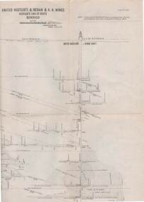
 Bendigo Historical Society Inc.
Map - STRUGNELL COLLECTION: UNITED HUSTLER'S & REDAN & K.K.MINES, September 1913
Map, Hustler's Line of Reefs, Bendigo, United Hustler's & Redan, & K.K.Mines, Plate No.XXV11 (27), Long Gully, Lightning Hill Line of Reefs at surface.Dated September 1913 //Bulletin 33.Signed H.A.Whitelaw.Underground Survey Office,Bendigo,map, bendigo, united hustler's, redan, k.k.mines -
 Bendigo Historical Society Inc.
Map - STRUGNELL COLLECTION: UNITED HUSTLER'S & REDAN & K.K.MINES, September,1913
Map, United Hustler's & Redan & K.K.Mines, Hustler's Line of Reefs, Bendigo.Plat No.XXX1(31),. NOTE:- Plates 4,8,13,20,26,& 31 form a Longitudinal Section from Fortuna Hustler's to Hystler's Consols Mine. Bulletin 33.Signed H.A.Whitelaw. Drawing shows the vertical shafts descending to over 1932 feet and 1805 feet respectively .Underground Survey Office, Bendigo.map, bendigo, united hustler's, redan, k.k.mines -
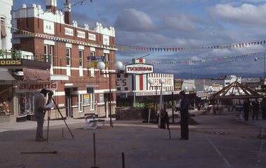 Stawell Historical Society Inc
Photograph, Ian McCann, Main Street - Gold Reef Mall, c 1987
Survey works fror the mallgold reef mall -
 Stawell Historical Society Inc
Map, Special Surveys, District of Ararat, 1869
Special Surveys, District of Araratstawell -
Stawell Historical Society Inc
Map, Special Surveys, District of Ararat, 1968
Special Surveys, District of Araratstawell -
 Bendigo Historical Society Inc.
Book - LARRITT'S SURVEY, 1854-1860
Larritt's Survey Enlarged mapsrichard larritt, survey, goldfields -
Clunes Museum
Document - GEOLOGICAL SURVEY, PROFESSOR. J.W.GREGORY, F.R.S, D.SC., DIRECTOR, CIRCA 1903
NO 6 THE CLUNES GOLD FIELDSBULLETINS OF THE GEOLOGICAL SURVEY OF VICTORIAlocal history, docoments, geological survey, mining -
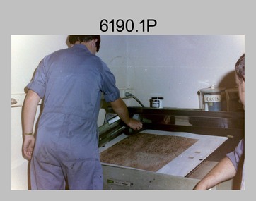 Bendigo Military Museum
Photograph - Lithographic Technicians preparing a Cromalin map proof at the Army Survey Regiment, Fortuna Villa Bendigo, c1990s
These six photographs were most likely taken in the 1990s in Lithographic Squadron at the Army Survey Regiment, Fortuna, Bendigo. There is no annotation describing the date or personnel in the photographs. Cromalin proofing was a laminate and dry powder proofing system introduced in 1978. The system allowed the production of true to colour proofs, mainly for the proofing of orthophoto maps and process printed 1:250,000 JOG that used positive printing plates. It was upgraded in 1986. The pre-press proof was a cost-effective way of producing a one-off visual copy of the map or chart product. It enabled cartographers to perform a quality inspection and correct any faults before publication. The pre-press proof was deemed authoritative before its release to Print Troop for bulk printing and distribution.This is a set of six photographs of lithographic technicians preparing Cromalin map proofs at the Army Survey Regiment, Bendigo c1990s. The photographs were on 35mm negative film and were scanned at 96 dpi. They are part of the Army Survey Regiment’s Collection. .1) to .6) - Photo, colour, c1990s, printer technician SPR Shona Hastie, Lithographic Squadron. .1P to .6P – no annotationroyal australian survey corps, rasvy, army survey regiment, army svy regt, fortuna, asr, litho -
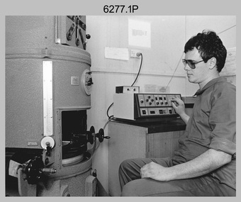 Bendigo Military Museum
Photograph - Map Production and Technical Services – Army Survey Regiment, Fortuna, Bendigo, July 1986
This is a collection of six photos of personnel and civilians undertaking technical tasks from Technical Services and the Air Survey, Cartographic and Lithographic Squadrons. The photos were taken at the Army Survey Regiment, Fortuna, Bendigo in July 1986. This is a set of six photographs of Army Survey Regiment personnel and civilians undertaking technical activities at Fortuna, Bendigo, in July 1986. The photographs were printed on photographic paper and are part of the Army Survey Regiment’s Collection. The photographs were scanned at 300 dpi. .1) - Photo, black & white, 1986, BARCRO work area WILD U4A Diapositive Camera, SPR Rob Jones. .2) - Photo, black & white, 1986, Aerotriangulation work area, SSGT Greg Buckingham. .3) - Photo, black & white, 1986, Technical Services in Building 16A. L to R: SSGT Andy Wilson, Tony Spurling, Pat Thwaites. .4) - Photo, black & white, 1986, RAAF Charting, L to R: SGT Paul Leskovec, SPR Toni Martin, FLT LT Don Stebbings .5) - Photo, black & white, 1986, Camera Section, CPL John Whaling. .6) - Photo, black & white, 1986, Print Troop, SPR Daryl South..1P – Annotated on back ‘JUL 86 SPR Rob Jones Barcro’ .2P – Annotated on back ‘JUL 86 SSGT Greg Buckingham Aerotrig’ .3P – Annotated on back ‘JUL 86 SSGT Andy Wilson, Mr Tony Spurling, Mr Pat Thwaites. Tech Services’ .4P – Annotated on back ‘JUL 86 SGT Paul Leskovec CSM, SPR Tony Martin, FLT LT Don Stebbings RAAF Charting’ .5P – Annotated on back ‘JUL 86 CPL John ‘Junior’ Whaling Camera Section LITHO’ .6P – Annotated on back ‘JUL 86 SPR Daryl South LITHO SQN’royal australian survey corps, rasvy, army survey regiment, army svy regt, fortuna, asr, air survey, litho, carto -
 Bendigo Military Museum
Photograph - 4th Field Survey Squadron – Operation ARIGHT 93, Queensland, 1993
This is a set of 42 photographs taken during 4th Field Survey Squadron’s deployment on Operation ARIGHT 93 in North Queensland from the 30th of August to the 8th of October 1993. The Survey Field Completion area of operations was Weipa near the top end of the Cape York Peninsula. Survey parties conducted field checking of topographic maps covering Bamaga, Heathlands, Weipa, Lockhart River and Strathgordon in Perentie 110 Series Survey variant FFR Land Rovers. Hand-held Trimble and Magellan GPS receivers were used to assist with navigation and to position remote isolated features. Three Bell Kiowa LOH helicopters provided by 162 Recce Sqn supported field checking operations. Supplementary and Vital Asset Protection photography was taken by air camera operators in AAAvn Nomad aircraft from 173 Survl Sqn fitted with an RC10 aerial camera.This is a set of 42 photographs taken in 1993 durin8g 4th Field Survey Squadron’s deployment on Operation ARIGHT in North Queensland. The colour photographs are on 35mm negative film and are part of the Army Survey Regiment’s Collection. The photographs were scanned at 96 dpi. .1) - Photo, colour, 1993. Survey party in Perentie 110 Series Land Rover navigates through Cape York Peninsula sand hills. .2) - Photo, colour, 1993. Cape York Peninsula sand hills. .3) - Photo, colour, 1993. Cape York Peninsula Island. .4) - Photo, colour, 1993. Survey party in Perentie 110 Series Land Rover enters a Cape York Peninsula beach. .5) - Photo, colour, 1993. SPR Kim Baker takes a break on a Cape York Peninsula beach. .6) - Photo, colour, 1993. L to R: MAJ Andy Cordova (USA Exchange) from the Army Survey Regiment and unidentified civilians. .7) to .14) - Photo, colour, 1993. Cape York Peninsula topography. .15) - Photo, colour, 1993. Unidentified surveyor in Bell Kiowa LOH helicopter. .16) - Photo, colour, 1993. Bell Kiowa LOH helicopter circles base camp. .17) to .18) - Photo, colour, 1993. Cape York Peninsula topography. .19) - Photo, colour, 1993. Vehicle convoy taking a break. L to R: LT John Bath (Detachment OC), unidentified (x2), SPR Chris Pearse. .20) - Photo, colour, 1993. Vehicle convoy taking a break. .21) - Photo, colour, 1993. Vehicle convoy ready to go. SPR Chris Pearse. .22) - Photo, colour, 1993. Vehicle convoy on the move. .23) - Photo, colour, 1993. Cape York Peninsula topography. .24) - Photo, colour, 1993. Unidentified personnel. .25) - Photo, colour, 1993. SGT Neale ‘Tex’ Houston. .26) - Photo, colour, 1993. Ground below a Bell Kiowa LOH helicopter .27) - Photo, colour, 1993. L to R: SPR Mark Sinderberry and CPL Stuart Adrain in a Bell Kiowa LOH helicopter. .28) & .29) - Photo, colour, 1993. Ground below a Bell Kiowa LOH helicopter. .30) - Photo, colour, 1993. Base camp viewed from a Bell Kiowa LOH helicopter. .31) - Photo, colour, 1993. Cape York Peninsula topography in recovery after burn-off. .32) & .33) - Photo, colour, 1993. SPR Kim Baker contemplates crossing this bridge in his Land Rover. .34) - Photo, colour, 1993. SPR Kim Baker takes a break next to a billabong. .35) - Photo, colour, 1993. Survey party in Perentie 110 Series Land Rover crosses a creek. .36) - Photo, colour, 1993. Cape York Peninsula bush fire in distance. .37) - Photo, colour, 1993. Survey party in Perentie 110 Series Land Rover traverses a sand hill. .38) - Photo, colour, 1993. SPR Kim Baker. .39) - Photo, colour, 1993. Cape York Peninsula bush fire. .40) - Photo, colour, 1993. Cape York Peninsula topography. .41) & .42) - Photo, colour, 1993. Cape York Peninsula sand hills..1P to .42P – There are no personnel identified. ‘1993 OP ARIGHT’ annotated on negative sleeve.royal australian survey corps, rasvy, 4 fd svy sqn, op aright 93 -
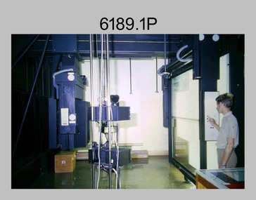 Bendigo Military Museum
Photograph - Photographic Technicians operating the KLIMSCH Camera at the Army Survey Regiment, Fortuna, c1980s
These four photographs were most likely taken in the mid-1980s in Lithographic Squadron at the Army Survey Regiment, Fortuna, Bendigo. The equipment operated by the technicians is the KLIMSCH camera. The main tasks undertaken by the technicians were most likely enlargements and reductions of map reproduction material. The KLIMSCH Commodore camera was introduced in 1953 and was the largest in the Southern Hemisphere. It was replaced with a new model of the same size in 1979. The new model with its computer-based interface provided productivity gains with improved speed and its consistent results led to less wastage in time and materials. Its variomat lens system provided improved retention of map feature linear weights during the camera reduction process. The camera which was specially made for the Army in Germany was fully automatic and power operated. It was claimed to be one of the biggest automatic cameras of its type in the world. It was made to the specifications of the Royal Australian Army Survey Corps to assist in the production of the very high standard maps for the Army. This is a set of four photographs of technicians operating the KLIMSCH Camera at the Army Headquarters Survey Regiment, Bendigo c1985. The photographs were on 35mm negative film and scanned at 96 dpi. They are part of the Army Survey Regiment’s Collection. .1) Photo, black & white, c1985, Frank Lenane operating the KLIMSCH Camera. .2) - Photo, black & white, c1985, KLIMSCH Camera. .3) to .4) - Photo, black & white, c1985, John Whaling operating the KLIMSCH Camera..1P to .4P – no annotationroyal australian survey corps, rasvy, army survey regiment, army svy regt, fortuna, asr, litho -
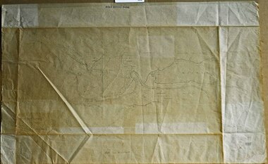 Orbost & District Historical Society
survey sheet, circa 1870's
E.L. Bruce, born in Ireland on July 1,1854, came to Australia in 1854 and joined the Lands Department. He spent most of his service in Gippsland. The journey to Sale then was made by ship to Port Albert and thence on horseback. He began his service in Gippsland as assistant district surveyor and for the last 12 years before retirement he was district surveyor and land officer. His territory extended from the boundary of Victoria in east Gippsland down to Wilson's Promontory with his headquarters at sale.This map is a useful reference tool.A survey map - Sheet No 3 SnowyRiver Survey. This is a copy of the original survey. It shows the properties of W.J.T. Clarke - two in Orbost and one in Newmeralla (sic),. it has a faded, undecipherable red stamp in the bottom right corner.Gipps Land Rivers No 32B E.L. Brucesurvey bruce-e.l snowy-river-c19th