Showing 15005 items
matching view
-
 Ringwood and District Historical Society
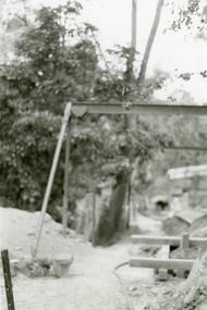
Photographs, 1979-80 MMBW pipe line project at Hubbard Reserve, North Ringwood � View along MMBW work line in east end of Hibberd's, showing grating over mole boring pit
Part of a 43-photo record of the MMBW�s engineering feat in drilling a 12 inch pipe line up to 40 feet deep through rock hardened by volcanic action associated with geological fault that occurs along the line. The work took place from October 1979 to May 1980 on the southern boundary of Hubbard Reserve, North Ringwood. The collection was presented to the Ringwood Historical Research Group by J Clarke on 9th June 1980.E560 N29 Feb 1980 A43 View along MMBW work line in east end of Hibberd's, showing grating over mole boring pit -
 Ringwood and District Historical Society
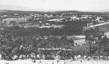
Photograph, Birds eye view of Ringwood 1912
Written onto photograph, "Birds eye view of Ringwood". Small photograph notes that photograph was taken in 1912 and that is shows the brickworks and Reimers house in Warrandyte Rd. -
 Greensborough Historical Society
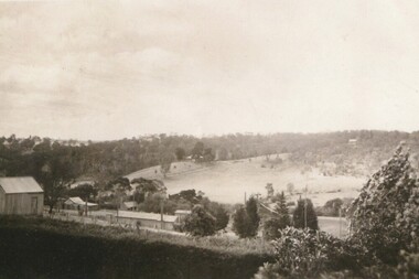
Photograph - Digital image, View of Lower Greensborough from Grimshaw Street, 1920c
View of rural Greensborough, late 19th or early 20th century.Shows the rural nature of the Greensborough landscape at this time.Digital copy of black and white photograph.greensborough -
 Greensborough Historical Society
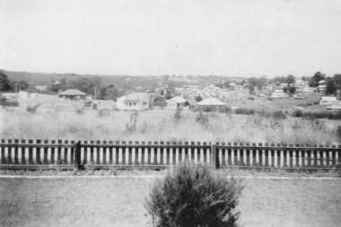
Photograph - Digital image, View from 11 Anama Street Greensborough, 1949c
View of Greensborough from the Evans home at 11 Anama Street.Digital copy of black and white photographanama street, evans family, june evans, june hall nee evans -
 Greensborough Historical Society
Photograph - Digital image, Marilyn Smith, 78 Main Street Construction - Rear View, 18/01/2016
Development on Main Street Greensborough (rear view), January 2016. Shows the changing streetscape of Main Street.Digital copy of colour photographmain street greensborough -
 Stawell Historical Society Inc
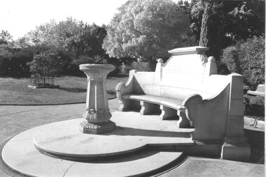
Photograph, Close up view of the Memorial Seat & Sundial at Central Park Stawell
Close up view of Seat and Sundial at Central Park Stawellstawell -
 Stawell Historical Society Inc
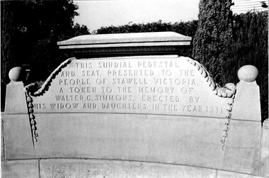
Photograph, Close up view of the Inscription on the Memorial Seat at Central Park Stawell
Close up view of Inscription on Seat at Central Park Stawellstawell -
 Marysville & District Historical Society
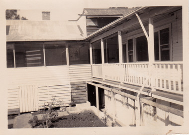
Photograph (item) - Black and white photograph, 1953
A black and white photograph of the view of the verandah from a guest's room at The Cumberland in Marysville. The photograph was taken in 1953.A black and white photograph of the view of the verandah from a guest's room at The Cumberland in Marysville. The photograph was taken in 1953.VIEW FROM/ WINDOW/ "CUMBERLAND"/ MARYSVILLE '53marysville, victoria, austalia, the cumberland, the cumberland guest house, cumberland house, accommodation, photograph -
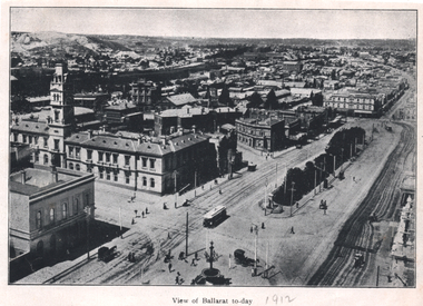 Ballarat Tramway Museum
Photograph - Illustration, "View of Ballarat today", c1910
Illustration or photograph taken from the Town Hall, looking North East towards Black Hill. The Post Office, railway yards, Sturt St buildings are in view. Has a tram eastbound at Lydiard St and another waiting to depart Grenville St. There are two horse-drawn cabs in the view. The road surfaces have marks - either from being watered or graded. On the rear is a photograph of R O Henderson's New Furniture warehouse, View Point Bendigo. Yields information of Ballarat c1910.Black and white Illustration cut from a journal"1912" in pencil alongside the image title.tramways, trams, sturt st, esco, grenville st, bridge st, lydiard st north, black hill, post office -
 Glenelg Shire Council Cultural Collection
Photograph, View of Portland Harbour and port, 1960s
Port of Portland Authority archives.Front: (no inscriptions) Back: (no inscriptions)port of portland, lady bay -
 Eltham District Historical Society Inc
Photograph, View from Porter Street, Eltham to south east, c.1994, 1994c
Colour photograph of view southeast from Porter Street, Eltham c.1994 showing new housing development on Riverview Estate formerly Fabbro farm.porter street, eltham, riverview estate, m fabbro -
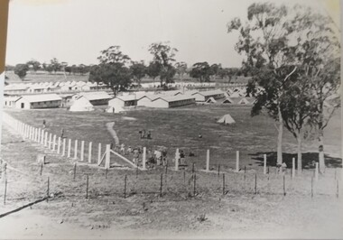 Tatura Irrigation & Wartime Camps Museum
Photograph, Camp 13 View, 1940
Photograph donated to Museum by Fred Ruddy who was one of the guards at Camp 13.Black and white photograph. General view from corner perimeter of Camp 13. Huts and tents particularly. It would seem tents the sleeping quarters of the guards.camp 13, fred ruddy, camp 13 sleeping quarters -
 Buninyong & District Historical Society
Photograph - B/W photograph, Eyre Cottage, former home of Robert Allen, c 1855, on S/W cnr. of Eyre and Winter Streets, side view from N/W, 1994
Original Building dates from around 1855, strong connection with Robert Allen, prominent citizen in early goldrush, links through him to Allen Store and Old Library.Built by prominent citizen and benefactor, early gold-rush dwellingEyre Cottage, former home of Robert Allen, c 1855, on S/W cnr. of Eyre and Winter Streets, side view from N/W.buninyong, eyre st, winter st, robert allen, streetscape, building -
 Buninyong & District Historical Society
Photograph - Original Photograph, Geoff Little, Whykes Slaughterhouse, Durham Lead, interior of boiler house, corner view, 1995
IndustryWhykes Slaughterhouse, Slaughterhouse Lane, Durham Lead, Whykes Slaughterhouse, Durham Lead, interior of boiler house, corner view. Colour and b/w copiesbuninyong, whykes, slaughterhouse, durham lead, butchers, boiler house -
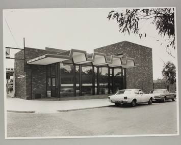 Ringwood and District Historical Society
Photograph, Exterior view of Ringwood North State Bank , north-east corner of Dickson's Crescent and Warrandyte Road
The new Ringwood North State Bank premises on the north-east corner of Dickson's Crescent. Exterior view. Unknown date. Opened 25 October 1971At the corner of Dickson's Crescent and Warrandyte Road, Ringwood North. Photographer Laurie Richards, 4 Tower Avenue, Alphington. Negative #71-3031 -
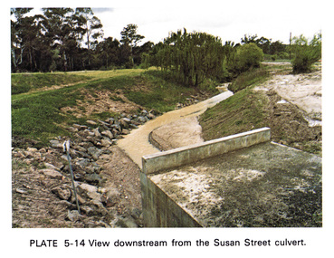 Eltham District Historical Society Inc
Work on paper (Sub-Item) - Photograph, View downstream from the Susan Street culvert
Colour photograph of the view downstream from the Susan Street culvert, Elthameltham, susan street, culvert, drain, channel -
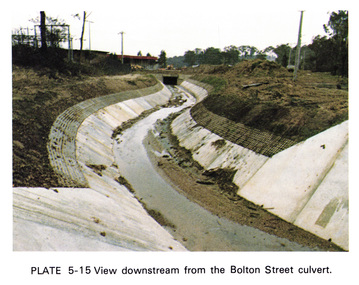 Eltham District Historical Society Inc
Work on paper (Sub-Item) - Photograph, View downstream from the Bolton Street culvert
Colour photograph of the view downstream from the Bolton Street culvert, Elthameltham, channel, concrete, drain, bolton street -
![Photograph - Digital Image, Greensborough Cemetery [view 3] 2013, 18/06/2013](/media/collectors/4f729f5697f83e03086015b8/items/54c5f91f2162f1173055ddc2/item-media/54c5f9512162f1173055dfc8/item-fit-380x285.jpg) Greensborough Historical Society
Greensborough Historical SocietyPhotograph - Digital Image, Greensborough Cemetery [view 3] 2013, 18/06/2013
View of Greensborough Cemetery, June 18th 2013. Photography by Marilyn Smith.Greensborough Cemetery was created when land was given for the cemetery by Mr William Poulter, a local settler, about 1864. The cemetery holds the graves of many early settlers in the district. Digital copy of colour photograph of Greensborough Cemeterygreensborough cemetery -
![Photograph - Digital Image, Greensborough Cemetery [view 2] 2014, 28/05/2014](/media/collectors/4f729f5697f83e03086015b8/items/54c5f9d52162f1173055e7b3/item-media/54c5fa9f2162f1173055f50b/item-fit-380x285.jpg) Greensborough Historical Society
Greensborough Historical SocietyPhotograph - Digital Image, Greensborough Cemetery [view 2] 2014, 28/05/2014
View of Greensborough Cemetery, 28th May 2014. Photography by Marilyn Smith.Greensborough Cemetery was created when land was given for the cemetery by Mr William Poulter, a local settler, about 1864. The cemetery holds the graves of many early settlers in the district. Digital copy of colour photograph of Greensborough Cemeterygreensborough cemetery -
![Photograph - Digital Image, Greensborough Cemetery [view 3] 2014, 28/05/2014](/media/collectors/4f729f5697f83e03086015b8/items/54c5fab02162f1173055f6ef/item-media/54c5fadf2162f1173055faf6/item-fit-380x285.jpg) Greensborough Historical Society
Greensborough Historical SocietyPhotograph - Digital Image, Greensborough Cemetery [view 3] 2014, 28/05/2014
View of Greensborough Cemetery, 28th May 2014. Photography by Marilyn Smith.Greensborough Cemetery was created when land was given for the cemetery by Mr William Poulter, a local settler, about 1864. The cemetery holds the graves of many early settlers in the district. Digital copy of colour photograph of Greensborough Cemeterygreensborough cemetery -
![Photograph - Digital Image, Greensborough Cemetery [view 4] 2014, 28/05/2014](/media/collectors/4f729f5697f83e03086015b8/items/54c5fb402162f1173055ff6a/item-media/54c5fb702162f117305602cc/item-fit-380x285.jpg) Greensborough Historical Society
Greensborough Historical SocietyPhotograph - Digital Image, Greensborough Cemetery [view 4] 2014, 28/05/2014
View of Greensborough Cemetery, 28th May 2014. Photography by Marilyn Smith.Greensborough Cemetery was created when land was given for the cemetery by Mr William Poulter, a local settler, about 1864. The cemetery holds the graves of many early settlers in the district. Digital copy of colour photograph of grave/headstone.greensborough cemetery -
![Photograph - Digital Image, Greensborough Cemetery [view 5] 2014, 28/05/2014](/media/collectors/4f729f5697f83e03086015b8/items/54c5fbcf2162f11730560d50/item-media/54c5fc022162f11730560fbb/item-fit-380x285.jpg) Greensborough Historical Society
Greensborough Historical SocietyPhotograph - Digital Image, Greensborough Cemetery [view 5] 2014, 28/05/2014
View of Greensborough Cemetery, 28th May 2014. Photography by Marilyn Smith.Greensborough Cemetery was created when land was given for the cemetery by Mr William Poulter, a local settler, about 1864. The cemetery holds the graves of many early settlers in the district. Digital copy of colour photograph of Greensborough Cemeterygreensborough cemetery -
![Photograph - Digital image, Greensborough Cemetery [view 1], 18/06/2013](/media/collectors/4f729f5697f83e03086015b8/items/54c5f72c2162f1173055bbb2/item-media/54c5f7722162f1173055c101/item-fit-380x285.jpg) Greensborough Historical Society
Greensborough Historical SocietyPhotograph - Digital image, Greensborough Cemetery [view 1], 18/06/2013
View of Greensborough Cemetery, June 18th 2013. Photography by Marilyn Smith.Greensborough Cemetery was created when land was given for the cemetery by Mr William Poulter, a local settler, about 1864. The cemetery holds the graves of many early settlers in the district. Digital copy of colour photograph of Greensborough Cemeterygreensborough cemetery -
![Photograph - Digital Image, Greensborough Cemetery [view 2] 2013, 18/06/2013](/media/collectors/4f729f5697f83e03086015b8/items/54c5f8802162f1173055d3d6/item-media/54c5f8ba2162f1173055d66a/item-fit-380x285.jpg) Greensborough Historical Society
Greensborough Historical SocietyPhotograph - Digital Image, Greensborough Cemetery [view 2] 2013, 18/06/2013
View of Greensborough Cemetery, June 18th 2013. Photography by Marilyn Smith.Greensborough Cemetery was created when land was given for the cemetery by Mr William Poulter, a local settler, about 1864. The cemetery holds the graves of many early settlers in the district. Digital copy of colour photograph of Greensborough Cemeterygreensborough cemetery -
![Photograph - Digital Image, Greensborough Cemetery [view 1] 2014, 28/05/2014](/media/collectors/4f729f5697f83e03086015b8/items/581060aed0cdd12660a1c09d/item-media/581060f6d0cdd12660a1ece7/item-fit-380x285.jpg) Greensborough Historical Society
Greensborough Historical SocietyPhotograph - Digital Image, Greensborough Cemetery [view 1] 2014, 28/05/2014
View of Greensborough Cemetery, 28th May 2014. Photography by Marilyn Smith.Greensborough Cemetery was created when land was given for the cemetery by Mr William Poulter, a local settler, about 1864. The cemetery holds the graves of many early settlers in the district. Digital copy of colour photograph of Greensborough Cemetery -
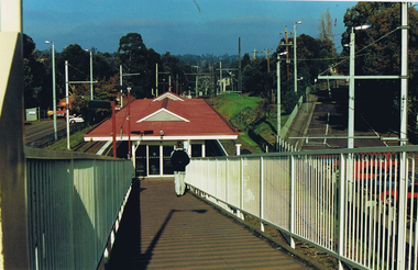 Greensborough Historical Society
Photograph - Digital image, Frank Solomon, Greensborough Station: view down ramp, 1990c
Greensborough Station: view down ramp from pedestrian overpass to station.Digital copy of colour photographgreensborough station -
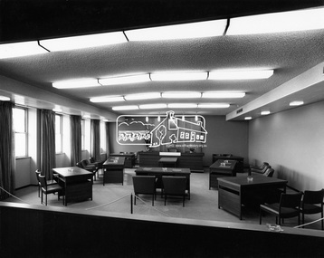 Eltham District Historical Society Inc
Photograph, Hugh Fisher, Eltham - View of Council Chamber, c.1965, 1965
View of Council Chamber in brand new Eltham Shire Offices 1965This photo forms part of a collection of photographs gathered by the Shire of Eltham for their centenary project book, "Pioneers and Painters: 100 years of the Shire of Eltham" by Alan Marshall (1971). The collection of over 500 images is held in partnership between Eltham District Historical Society and Yarra Plenty Regional Library (Eltham Library) and is now formally known as 'The Shire of Eltham Pioneers Photograph Collection.' It is significant in being the first community sourced collection representing the places and people of the Shire's first one hundred years.Digital imagesepp, shire of eltham pioneers photograph collection, eltham, eltham shire office, council chamber -
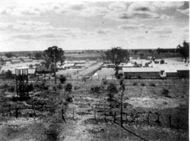 Tatura Irrigation & Wartime Camps Museum
Photograph, View of Camp 3
View of Camp 3 taken from Southern tower, c.1946. -
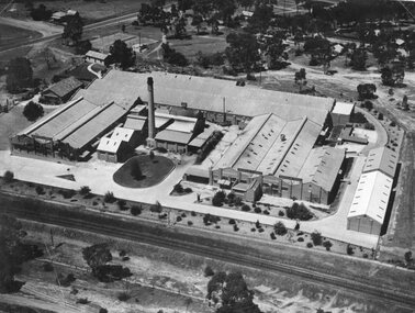 Stawell Historical Society Inc
Photograph, North Western Woollen Mills with the Rail line in foreground -- Aerial View
North Western Woollen Mills Aerial View. Rail line in foregroundstawell industry -
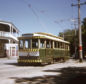 Ballarat Tramway Museum
Slide - 27 mm sq slide/s - set of 5, Andrew Howlett, Tram 26 on private tour - View Point line, Mar. 1969
Yields information about a special tram service during March 1969 and some unusual moves.Set of four Colour slides, Kodak white cardboard mount, developed March 1969 of a special tram that apparently ran from the depot via View Point, shunted at Ripon St and again at Hospital corner. ..1 - No. 26 running a special in Wendouree Parade, View Point, with the Lake View Hotel. .2 - ditto - and a catering company in the view, as well as a Telephone box. .3 - running from Ripon St into Sturt St. .4 - shunting at Hospital corner - then possibly crossed 34 at Parker St Loop - see 7668. .5 - ditto, but before .4, with the tram rounding the corner from the North side of Sturt St into Drummond St. It would then appear that the tram then reversed a bit before going back into Sturt St onto the South side. One of a series of tour photos - see Reg item 7667, 7668, 7683 and 7701.ballarat, tramways, trams, view point, wendouree parade, ripon st, hospital corner, sturt st, tours, tram 26