Showing 1195 items
matching bendigo east
-
 Bendigo Historical Society Inc.
Map - YARRAYNE : COUNTY OF BENDIGO, 6-1-32
... Map. Yarrayne, County of Bendigo, Janiember East; Pompapiel..., County of Bendigo, Janiember East; Pompapiel, Salisbury ...Map. Yarrayne, County of Bendigo, Janiember East; Pompapiel, Salisbury, Bridgewater, Salisbury West, Powlett. Photo-Lithographed at the Department of Lands and Survey, Melbourne. Price 2/-. 6-1-32. (number 12 in map cupboard 1)H.J. Green, Government Printermap, bendigo, yarrayne -
Bendigo Historical Society Inc.
Map - CAMPBELL COLLECTION: BENDIGO AND DISTRICT MAPS, 1982
... , North Bendigo, City of Bendigo, Bendigo East, Kennington, West... East, Kennington, West Bendigo, Golden Square, Quarry Hill ...Map. Forest Commission Victoria, Bendigo Forest District, Sub-Plan 1 District Fire Prevention Plan, Greater Bendigo Area. Prevention Strategy Plan. Shire of Marong, Shire of Huntly, Borough of Eaglehawk, Shire of Strathfieldsaye, Sailors Gully, Epsom, Jackass Flat, White Hills, California Gully, Maiden Gully, Long Gully, North Bendigo, City of Bendigo, Bendigo East, Kennington, West Bendigo, Golden Square, Quarry Hill, Flora Hill, Spring Gully, Kangaroo Flat.Base prepared 1982. (number 397 in map cupboard 1)map, bendigo, forest district -
 Bendigo Historical Society Inc.
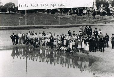
Photograph - VAL CAMPBELL COLLECTION: PHOTOGRAPH OF A LARGE GROUP OF PEOPLE STANDING BESIDE A POOL
... on the back of the photo: Bendigo East Pool the Beginning Land.... Written on the back of the photo: Bendigo East Pool the Beginning ...Black and white photo of a large group of people standing beside a pool which has been dug from the surrounding grassed area. The group is a mixture of adults and children. Some of the men are holding long poles and one boy a shovel. In the background sheep are grazing behind a high fence. Written on the front of the photo: Early Pool Site Bgo East. Written on the back of the photo: Bendigo East Pool the Beginning Land was donated to the Committee by Mr Moog who owned large amounts of property in the area. It was then called Moog Park then (not decipherable) then Eastern Park.recreations, sports, swimming -
Bendigo Historical Society Inc.
Map - SANDHURST (PART), Circa 1880's
... , Northwards from Lloyd St. East bendigo. ( number 212 in Map Cupboard... St. East bendigo. ( number 212 in Map Cupboard 1) Map ...Map: Parish plan showing a section of the city of Sandhurst, Northwards from Lloyd St. East bendigo. ( number 212 in Map Cupboard 1)map, bendigo, parish plan, lloyd st. sandhurst, bendigo -
 Bendigo Historical Society Inc.
Functional object - Seal Embossing Press
... , the Company had completed its factory and plant at Bendigo East, ready..., the Company had completed its factory and plant at Bendigo East, ready ...The Corona Paint Company Pty. Ltd. Bendigo was formed in November 1920 with £10,000 capital, in £1 shares. By July 1921, the Company had completed its factory and plant at Bendigo East, ready to begin the manufacture of paints. The Corona Paint works were opened on Saturday 28 January by the Prime Minister (Mr. Hughes) during a visit to Bendigo. Many new manufacturing industries were opened during this time after calls to address the decline of mining in the region. The factory of the CORONA PAINT COMPANY, BENDIGO, was advertised for sale in The Argus on 5 October 1923. It consisted of a “building on a railway siding, plant and machinery, including dry grinding plant, kalsomine mixer, paint mill, furnace, electric motor, etc., large stores of raw and finished material, kalsomine with range of 21 colours, oil paints, &c.”A cast iron embossing press. It's painted black with gold coulered floral decorations. The base is 18 centimetres long, nine centimetres wide and one and a half centimetres thick. A curved protrusion rises from the base that is eight centimetres by four centimetres which narrows to four centimetres by two and a half centimetres with a three-quarter centimetre wide slot. Inside the slot is a lever action with a ten centimetre by two and a half centimetre wooden handle. There is a removeable die on the end of the lever and an opposite removeable die the base. A small oval metal disc with paten no 3965 on is attached. The seal is The Corona Paint Company proprietary Limited seal embossing press, corona paint company -
 Bendigo Historical Society Inc.
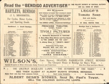
Newspaper - RANDALL COLLECTION: THE BENDIGO ADVERTISER FOR FULLEST REPORTS OF FOOTBALL MATCHES, 1923
... Stores, Bendigo; Sandhurst V. South Bendigo; Bendigo East V...; Bendigo East V. Rochester; T.E.Turner, The Electrical Shop; J ...Newspaper, The Bendigo Advertiser for fullest reports of Football matches and all kinds of sport.Hartleys, Bendigo; Arnold Lovell , Shamrock Buildings; Leggo's Tomato Soup; Princess Theatre; Wilson's Drapers, Hargreaves St, Bendigo;Albert Bush's Stores, Bendigo; Sandhurst V. South Bendigo; Bendigo East V. Rochester; T.E.Turner, The Electrical Shop; J..Friswell , Bendigo's Leading Butcher; Shamrock Tobacco Store; H.R.Hughan's View point News Agent; Les Pascoe Saddler Hargreaves St.; Cambridge Press; After the Match have a pasty at Percy Smith's Opposite Law Courts. Bendigo Football Premiership Records from 1880 to 1922.newspaper, bendigo advertiser, football records -
 Ballarat Tramway Museum
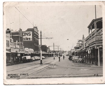
Photograph - Black & White Photograph/s
... , of Mitchell St Bendigo looking east towards the Railway Station. Has..., of Mitchell St Bendigo looking east towards the Railway Station. Has ...Black and white photograph, reproduced for sale, of Mitchell St Bendigo looking east towards the Railway Station. Has the title "Mitchell Street Bendigo" in the bottom left hand corner and " No. 5" in the bottom right hand corner. Shows the tramway overhead, track, centre poles. Photo early 1950's. trams, tramways, bendigo, mitchell st -
 Bendigo Historical Society Inc.
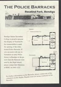
Document - THE POLICE BARRACKS ROSALIND PARK BENDIGO
... East, Ms Willi Carney, Mayor, City of Greater Bendigo, Mr Steve... East, Ms Willi Carney, Mayor, City of Greater Bendigo, Mr Steve ...Pale yellow page containing a picture and upstairs and downstairs plans of the Police Barracks, Rosalind Park, Bendigo. On the back is the history of the building and it's use over the years since it was completed in 1860. On the 9 November 2002, the Bendigo Senior Secondary College presented a display of Police memorabilia to mark the opening of the refurbished Police Barracks. There were tours of the Barracks, displays and a Mounted Police display with horses. The Official Party was: Mr Graham Bastian, Principal, Bendigo Senior Secondary College, Mr Bob Cameron MP, member for Bendigo West, Ms Jacinta Allan MP, Member for Bendigo East, Ms Willi Carney, Mayor, City of Greater Bendigo, Mr Steve Gibbons MHR, Member for Bendigo and Mr Rob Blachford. There is a running sheet for the opening.buildings, government, police barracks, the police barracks rosalind park bendigo, bendigo senior secondary college, high school, bob marmion, p o flanagan, public works, alfred t snow, john robertson, bendigo goldfield, bendigo gaol, bendigo supreme court building, camp reserve, mounted constable james 'tiger' scholes 6438, education department, city of greater bendigo, graham bastian, willi carney, bob cameron mp, ms jacinta allan mp, steve gibbons mhr, bob blachford -
 Bendigo Historical Society Inc.
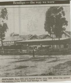
Newspaper - JENNY FOLEY COLLECTION: FERTILISER
... opened the this business in Day Street, East Bendigo in 1882... Street, East Bendigo in 1882. The clip is in a folder. Newspaper ...Bendigo Advertiser ''The way we were'' from 2000. Fertiliser: Bone Mills and Asphalt Works, circa 1900. Alfred Day opened the this business in Day Street, East Bendigo in 1882. The clip is in a folder.newspaper, bendigo advertiser, the way we were -
Bendigo Historical Society Inc.
Map - PANNOOBAMAWM : COUNTY OF BENDIGO, 1957
... Map. Pannoobamawm, County of Bendigo, Terrick Terrick East.... Pannoobamawm, County of Bendigo, Terrick Terrick East, Wanurp ...Map. Pannoobamawm, County of Bendigo, Terrick Terrick East, Wanurp, Pannoomilloo, Bamawm, Turrumberry, property allotments. Drawn and reproduced at the Department of Lands and Survey, 1957, Price 2/-. (number 410 in Map Cupboard 1 ).W.M. Houston, Government Printer, Melbourne.bendigo, hospital -
 Bendigo Historical Society Inc.
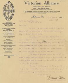
Document - BENDIGO TOTAL ABSTINENCE SOCIETY COLLECTION: VICTORIAN ALLIANCE, 2rd August 1917
... . They were very concerned about East Bendigo Electorate, because.... W.J.Campbell, J.P. Bendigo. They were very concerned about East Bendigo ...Document. A letter to Mr. W.J.Campbell, J.P. Bendigo. They were very concerned about East Bendigo Electorate, because of the character of a man in relation to our work. The present sitting member is one of the ones that are in Parliament, kept there by the beer interest.organisation, community, abstinence society -
Bendigo Historical Society Inc.
Map - WANURP: COUNTY OF BENDIGO, 1/12/33
... Map. Wanurp, County of Bendigo, Terrick Terrick East..., County of Bendigo, Terrick Terrick East, Mitiamo, Dingee, Milloo ...Map. Wanurp, County of Bendigo, Terrick Terrick East, Mitiamo, Dingee, Milloo, Pannoobamawm. L422+. Photo-Lithographed at the Department of Lands and Survey, Melbourne, Price 2/-. 1/12/33 ( number 411 in Map Cupboard 1 )H.J. Green, Government Printerbendigo, hospital -
 Bendigo Historical Society Inc.
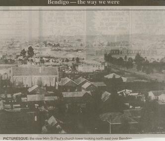
Newspaper - JENNY FOLEY COLLECTION: PICTURESQUE
... Bendigo Advertiser ''The way we were'' from 2000... church tower looking north east over Bendigo. The clip ...Bendigo Advertiser ''The way we were'' from 2000. Picturesque: the view from St'Paul's church tower looking north east over Bendigo. The clip is in a folder.newspaper, bendigo advertiser, the way we were -
 Bendigo Historical Society Inc.
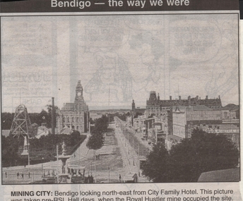
Newspaper - JENNY FOLEY COLLECTION: MINING CITY
... city: Bendigo looking north-east from City Family Hotel...Bendigo Historical Society Inc. Bendigo Historical Society ...Bendigo Advertiser ''The way we were'' from 1999. Mining city: Bendigo looking north-east from City Family Hotel. This picture was taken pre-RSL Hall days when the Royal Hustler mine occupied the site.newspaper, bendigo advertiser, the way we were -
Bendigo Historical Society Inc.
Map - WANURP : COUNTY OF BENDIGO, 1-12-33
... Map. Wanurp, County of Bendigo, Terrick Terrick East... of Bendigo, Terrick Terrick East, Mitiamo, Milloo, Pannoobamawm ...Map. Wanurp, County of Bendigo, Terrick Terrick East, Mitiamo, Milloo, Pannoobamawm. By authority H.J. Green, Government Printer.Photo-Lithographed at the Department of Lands and Survey, Melbourne. Price 2/-. 1-12-33. (number 9 in map cupboard 1)H.J. Green, Government Printermap, bendigo, wanurp -
 Bendigo Historical Society Inc.
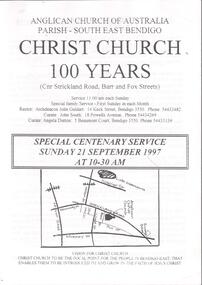
Document - CHURCHES OF BENDIGO COLLECTION: CHRIST CHURCH 100 YEARS
... Parish-South east Bendigo. Christ Church 100 years (cnr...: Anglican Church of Australia Parish-South east Bendigo. Christ ...Eleven pages document titled: Anglican Church of Australia Parish-South east Bendigo. Christ Church 100 years (cnr Strickland road, Barr and Fox Streets) Special centenary service Sunday 21 September 1997 at 10-30 am.church, church of christ, centenary -
 Bendigo Historical Society Inc.
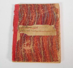
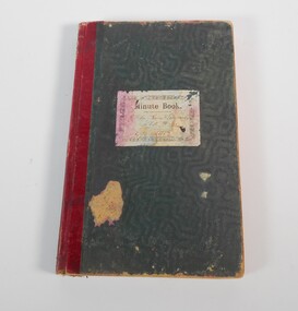
Book - WHITE HILLS READING ROOM COLLECTION: MINUTES BOOK 1900-1907
... coming apart. White Hills and East Bendigo Heritage Study - Stage... is in poor condition spine coming apart. White Hills and East Bendigo ...Hardcover minutes book of the White Hills Reading Room Committee from 1900 to 1907. The book is in poor condition spine coming apart. White Hills and East Bendigo Heritage Study - Stage 2 2016 vol 2 citations FINAL_0.pdfclubs, social, white hills reading room -
Bendigo Historical Society Inc.
Map - WANURP : COUNTY OF BENDIGO, 1-12-33
... Map. Wanurp, County of Bendigo, Terrick Terrick East... of Bendigo, Terrick Terrick East, Pannoobamawm, Milloo, Dingee ...Map. Wanurp, County of Bendigo, Terrick Terrick East, Pannoobamawm, Milloo, Dingee, Mitiamo. Photo-Lithographed at the Dept. of Lands and Survey, Melbourne. Price 1/-. 1-12-33. By authority H.J. Green, Govt. Printer. (number 26 in map cupboard 1)H.J. Green, Govt. Printermap, bendigo, wanurp -
 Bendigo Historical Society Inc.
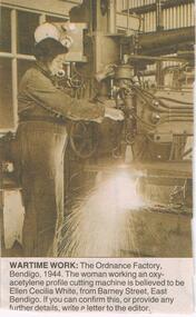
Newspaper - JENNY FOLEY COLLECTION: WARTIME WORK
... , East Bendigo.... is believed to be Ellen Cecilia White from Barney Street, East Bendigo ...BHS CollectionBendigo Advertiser ''The way we were'' from Saturday, November 27, 2004. Wartime work: the Ordnance factory, Bendigo, 1944. The woman working an oxy-acetylene profile cutting machine is believed to be Ellen Cecilia White from Barney Street, East Bendigo.newspaper, bendigo advertiser, the way we were -
 Bendigo Historical Society Inc.
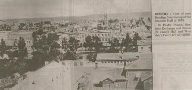
Newspaper - JENNY FOLEY COLLECTION: SCENIC, 11/11/2000
... November 11, 2000. Scenic: A view of East Bendigo from the top... of East Bendigo from the top of the Masonic Hall in 1875. St ...Bendigo Advertiser ''The way we were'' from Saturday November 11, 2000. Scenic: A view of East Bendigo from the top of the Masonic Hall in 1875. St. Paul's Church, Beehive Exchange and Stores, St.James' Hall and Warden's Court are all visible. The clip is in a folder.newspaper, bendigo advertiser, the way we were -
 Bendigo Historical Society Inc.
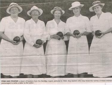
Newspaper - JENNY FOLEY COLLECTION: PRIM AND PROPER
... . Jenkins (South Bendigo), Mrs. Olive Body (East Bendigo) and Mrs... Bendigo), Mrs. Olive Body (East Bendigo) and Mrs. Strode (Golden ...Bendigo Advertiser ''The way we were'' from 2003. Prim and proper: a team of bowlers from the Bendigo region pictured in 1952. Bendigo Advertiser ''The way we were'' from 2003. Identified: the women are picture at a Bendigo and District Ladies Bowls Association Champion of Champions event on March 3, 1952. They are Miss Okey (Kangaroo Flat) Mrs. Wallace (white Hills), Mrs. Jenkins (South Bendigo), Mrs. Olive Body (East Bendigo) and Mrs. Strode (Golden Square). The winner of the Champions of Champion was Mrs. Jenkins. The clip is in a folder.newspaper, bendigo advertiser, the way we were -
 Ballarat Tramway Museum
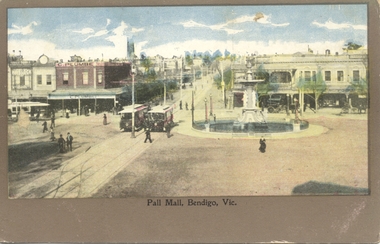
Postcard, Pall Mall Bendigo, early 1900's
... Postcard, coloured, Pall Mall Bendigo, looking east towards... east corner of the intersection. Title "Pall Mall, Bendigo Vic ...Postcard, coloured, Pall Mall Bendigo, looking east towards the Railway Station. Has three trams in the view, along with the fountain. Has C. Plumbe store on the north east corner of the intersection. Title "Pall Mall, Bendigo Vic." Note the small space for a message under the image. On rear, undivided back, with "Post card", "Address to be written on this side" and position for stamp. In the top left hand corner, has "Ian Barkla's" hand stamp. Ian Barkla stamptrams, tramways, bendigo, pall mall -
Bendigo Historical Society Inc.
Map - JANIEMBER WEST : COUNTY OF BENDIGO, September 1955
... Map. Janiember West, County of Bendigo, Powlett, Janiember.... Janiember West, County of Bendigo, Powlett, Janiember East, Jarklan ...Map. Janiember West, County of Bendigo, Powlett, Janiember East, Jarklan, Kinypanial, River Loddon, Kelsh's Lagoon. By authority W.M. Houston, Government Printer. Drawn and reproduced at the Department of Lands and Survey, Melbourne. Price 2/-.September 1955. (number 64 in map cupboard 1)W.M. Houston, Government Printermap, bendigo, janiember west -
 Bendigo Historical Society Inc.
Book - WHITE HILLS READING ROOM COLLECTION: W. STUCKENSCHMIDT DIARY 1908-1940
... and 1914, from 1916 to 1921 and 1922 to 1939. White Hills and East... to 1939. White Hills and East Bendigo Heritage Study - Stage 2 ...Small black cover book of W. Stuckenschmidt ''Loafer'' covering the years 1908 to 1940. No entries for years 1913 and 1914, from 1916 to 1921 and 1922 to 1939. White Hills and East Bendigo Heritage Study - Stage 2 2016 vol 2 citations FINAL_0.pdfclubs, social, white hills reading room -
Bendigo Historical Society Inc.
Map - PANNOOBAMAWM : COUNTY OF BENDIGO, 7-9-15
... Map. Pannoobamawm, County of Bendigo, Terrick Terrick East.... Map. Pannoobamawm, County of Bendigo, Terrick Terrick East ...Map. Pannoobamawm, County of Bendigo, Terrick Terrick East, Wanurp, Pannoomilloo, Bamawm,Turrumberry. By authority Albert J. Mullett, Government Printer, Melbourne. Photographed at the Deptartment of Lands and Survey, Melbourne. By W.J. Butson 7-9-15. Price 1/-. (number 81 in map cupboard 1)W.J. Butson, Government Printer, Melbourne.map, bendigo, pannoobamawm -
 Bendigo Historical Society Inc.
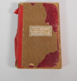
Book - WHITE HILLS READING ROOM COLLECTION: MINUTES BOOK 1944-1961
... pages. Black cover with red spine. White Hills and East Bendigo... spine. White Hills and East Bendigo Heritage Study - Stage 2 ...Minute book of the White Hills Reading Room covering the years from 1944 to 1961. The book has three hundred eighty-two pages. Black cover with red spine. White Hills and East Bendigo Heritage Study - Stage 2 2016 vol 2 citations FINAL_0.pdfclubs, social, white hills reading room -
 Bendigo Historical Society Inc.
Book - WHITE HILLS READING ROOM COLLECTION: MINUTES BOOK 1912-1924
... . Black cover with red spine. White Hills and East Bendigo... Hills and East Bendigo Heritage Study - Stage 2 2016 vol 2 ...Minute book for the White Hills Reading Room from 1912 to 1924. The book has two hundred eighty-three pages all full. Black cover with red spine. White Hills and East Bendigo Heritage Study - Stage 2 2016 vol 2 citations FINAL_0.pdfclubs, social, white hills reading room -
 Bendigo Historical Society Inc.
Book - WHITE HILLS READING ROOM COLLECTION: MINUTES BOOK 1924-1943
... . The book has damaged on the spine. White Hills and East Bendigo.... White Hills and East Bendigo Heritage Study - Stage 2 2016 vol 2 ...Minutes book of the White Hills Reading Room from 1924/1943. The book has three hundred and seventy five pages all filled. The book has damaged on the spine. White Hills and East Bendigo Heritage Study - Stage 2 2016 vol 2 citations FINAL_0.pdfclubs, social, white hills reading room -
 Bendigo Historical Society Inc.
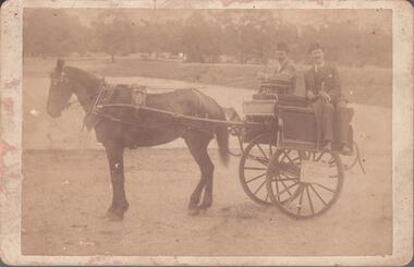
Photograph - CONSTABLE JOHN BARRY COLLECTION: JOHN AND THOMAS BARRY IRISH JAUNTING CAR
... , Lyttleton Terrace East, Bendigo. Their residential address...Bendigo Historical Society Inc. Bendigo Historical Society ...Sepia photo, horse drawn Irish Jaunting Car. John (Jnr) and Thomas Barry are sitting back to back in the car. John and Thomas won a medal (3822.5) at the Bendigo Agricultural Show in 1892. Their address was given as Barry Bros., Coachbuilders, Lyttleton Terrace East, Bendigo. Their residential address was Lucan Street.Unknownperson, bendigo, john and thomas barry -
Bendigo Historical Society Inc.
Map - POMPAPIEL : COUNTY OF BENDIGO, 1-10-27
... Map. Pompapiel, County of Bendigo, Calivil, Janiember East..., County of Bendigo, Calivil, Janiember East, Yarrayne, Salisbury ...Map. Pompapiel, County of Bendigo, Calivil, Janiember East, Yarrayne, Salisbury, Yallook, Talambe, Judyong Creek, Bullock Creek, Pompapiel Creek, Edeyrn Estate. Photo-Lithographed at the Department of Lands and Survey, Melbourne by W.J. Butson, 1-10-27, Price 1/-. (number 4 in map cupboard 1)W.J. Butson, Government Printermap, bendigo, pompapiel