Showing 466 items
matching conservation areas
-
 Phillip Island Conservation Society Inc.
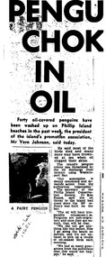
Work on paper - Photocopy of newspaper cutting, "PENGU/ CHOK/ IN/ OIL" (meant to be : "Penguins choke in oil"
With the establishment of the large heavy industrial zone at Hastings in the late 1960s, which included the BP oil refinery using the Port of Hastings at the north-western arm of Western Port, a number of environmental problems predicted by both scientists and conservationists arose. The main shipping channel on the western arm of Western Port was dredged, causing suspended particles affecting seagrass beds. With inadequate regulation around discharge of bilge water within the bay, and oil spillage, oil pollution affecting both seabirds and coastal areas was not uncommon. This report of 40 penguins actually known to have been killed by an oil spill event was typical of reports at the time. The 2 men quoted – Vernon Johnson and Ken Pound – were well known conservationists. Vernon and his wife Nora owned the Kingston Gardens picnic and zoo business where they cared for many injured wildlife. Ken was a Phillip Island counsellor for a few years, and instrumental in the establishment of the Phillip Island conservation Society. He also contributed various documents and newspaper cuttings to this archive.This article is significant for being a record of an exact number of penguins found dead from oil spill pollution in Western Port. Also as a record of conservationists in the early years of community and environment movements both locally and in Australia. The article further gives evidence of linking tourism with wildlife.Photocopy of newspaper cutting. Black print with very dark black and white photo of Fairy (Little) Penguin. Poor reproduction due to older photocopy machine.(indecipherable) - late/1960s.little penguins, fairy penguins, eudyptula minor, penguin behaviour, phillip island tourist attractions, phillip island conservation society, oil spills, bp refinery hastings, port of hastings, western port, marine pollution, oil tankers, vernon johnson, ken pound, phillip island promotion association -
 Phillip Island Conservation Society Inc.
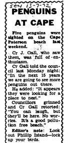
Work on paper - Photocopy of newspaper cutting, Wonthaggi Sentinel, or South Gippsland Sentinel Times, "PENGUINS/AT CAPE"
Cr J Gall was a councilor on the Borough of Wonthaggi Council. The Borough included Cape Paterson, where Cr Gall saw 5 little penguins on the beach. He described them as looking for somewhere to nest – that is, to dig burrows in the coast adjoining the Cape Paterson sandy beach. At that stage, the Wonthaggi state coal mine had been closed for 4 years and Wonthaggi had more emphasis on attracting different industries. There was little interest in flora and fauna of the area at that stage. Cr Gall’s unusual sighting of the Little Penguins possibly nesting at Cape Paterson attracted derision from the other councillors, and also a sarcastic Editor's Note from the newspaper's editor - none of which was not surprising for that era. The Borough of Wonthaggi was later amalgamated with the shires of Phillip Island and Bass, plus other areas of a couple of others local shires in 1994 to form Bass Coast Shire Council, which quickly moved to a heavy emphasis on flora, fauna and the tourism industry related to the environment generally.The article clearly demonstrates the disinterested if not dismissive attitude of the Borough of Wonthaggi councillors and the local newspaper editor at the time towards observations of flora and fauna. However, the article is also an interesting record of 5 Little Penguins being sighted at a beach where they were not known to have previously been seen.Photocopy of Single column newspaper article, black print on white paper. Article has curved line border design on top, sides. Cut off in copy at bottom edge. Five paragraphs in main article, and 1 paragraph at bottom marked: Editor's noteSEN 13 - 7 - 72 (South Gippsland Sentinel Times newspaper, 13th July, 1972)little penguins, fairy penguins, eudyptula minor, penguin behaviour, borough of wonthaggi, cr j gall -
 Phillip Island Conservation Society Inc.
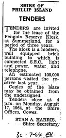
Work on paper - Photocopy of newspaper cutting, Wonthaggi or Powlett Express newspaper, "SHIRE OF/ PHILLIP ISLAND/ TENDERS", 30.7.1946
Shire of Phillip Island managed the Phillip Island Penguin Parade during this era, and made several improvements for visitors including the building of a kiosk for food and beverage and some souvenirs. The building was located on a bitumen area at the base of the hill along with a brick toilet block. The area was actually raised from creek bed adjacent to the bitumen area, with Little Penguin rookery either side. The Shire tendered out the contract for the running of this kiosk on a 3 yearly basis.This small public notice from a Wonthaggi newspaper at a time when no local newspaper was being published on Phillip Island, marks the time when the Shire of Phillip Island began to increase provision of tourist facilities at the Penguin Parade. The number of visitors being 100,000 for the previous year is also an excellent indication of the popularity of the Penguin Parade. The listing of infrastructure available to the building is useful.Photocopy of Public Notice, Rectangular. Single collumn with heading, sub-heading, 5 paragraphs of text and Name and position of Shire Secretary. Black and white."30-7-64 EX" Meaning: 30.07.1964. Powlett Express newspaper.phillip island penguin parade, shire of phillip island, penguin parade kiosk, tender process, penguin parade visitor numbers, sec state electricity commission, stan harris phillip island shire secretary -
 Phillip Island Conservation Society Inc.
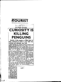
Work on paper - Newspaper cutting, Unknown journalist, the Express newspaper, Wonthaggi, "Tourist Curiosity is killing penguins", 30.01.1964
Due to increased numbers of tourists in the post-World War Two era, and the increased popularity of the Penguin Parade, without sufficient public education or protection of the penguin habitat, many Little Penguins perished during the 1960s. Trampling, unsupervised interference with the birds, unrestricted access to their dune habitat, plus predation by foxes, cats and dogs, led to most of the rookeries outside of the Summerland patrolled areas - such as on the west and north Phillip Island coasts, and parts of the south coast - being obliterated by the mid 1970s.this article is highly significant as it was published shortly before the establishment of the Phillip Island Conservation Society Inc in 1968, which commenced agitation to make management of Crown Land by Phillip Island Shire Council and government bodies accountable for protection of wildlife habitat on Phillip Island.photocopy of newspaper cutting. Black print on white paper. 3--1-64phillip island, penguin parade, little penguin, habitat destruction, penguin parade committee, shell house, -
 Wodonga & District Historical Society Inc
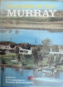
Book - The Book of the Murray, Lawrence, G. V.; and Smith, Graeme Kinross, 1975
This book contains contributions from 16 writers who have first-hand knowledge of the Murray River area. It provides a comprehensive picture of the river in all its aspects. It gives a fascinating look at one of Australia's most important geographical and historical features. Contributors and chapters in this book are: - 1. Past, Present and Future – G. V. Lawrence 2. The Structure of the Murray – Edmund D. Gill 3. Seeing the Murray – Graeme Kinross Smith 4. The Mountains at the Source – Elyne Mitchell 5. The Explorers – Leigh Betheras 6. The Irrigators – G. Arch Grosvenor 7. Murray Water Conservation – W. G. L. Harrison & K. E. Johnson 8. The Murray River Steamers – Ian Mudie 9. Pioneer Days: A Story of Seventy Years Ago – Dorothy Roysland 10. Birdlife of the Murray Valley – John Eckert 11 .Aborigines in the Murray Valley, How We Learned the Story – H. A. Lindsay, The Aboriginal Occupation – Norman B. Tindale 12. Fish of the Murray River – John S. Lake 13. Native Plants of the Murray Valley – J. H. Willis 14. Murray Wildlife – K. N. G. SimpsonThis publication has a hard cover with blue boards and a pictorial dust jacket. It consists of 264 pages.This book contains contributions from 16 writers who have first-hand knowledge of the Murray River area. It provides a comprehensive picture of the river in all its aspects. It gives a fascinating look at one of Australia's most important geographical and historical features. Contributors and chapters in this book are: - 1. Past, Present and Future – G. V. Lawrence 2. The Structure of the Murray – Edmund D. Gill 3. Seeing the Murray – Graeme Kinross Smith 4. The Mountains at the Source – Elyne Mitchell 5. The Explorers – Leigh Betheras 6. The Irrigators – G. Arch Grosvenor 7. Murray Water Conservation – W. G. L. Harrison & K. E. Johnson 8. The Murray River Steamers – Ian Mudie 9. Pioneer Days: A Story of Seventy Years Ago – Dorothy Roysland 10. Birdlife of the Murray Valley – John Eckert 11 .Aborigines in the Murray Valley, How We Learned the Story – H. A. Lindsay, The Aboriginal Occupation – Norman B. Tindale 12. Fish of the Murray River – John S. Lake 13. Native Plants of the Murray Valley – J. H. Willis 14. Murray Wildlife – K. N. G. Simpsonmurray river, australian geography, settlement on the murray river, native plants, aborigines in the murray valley, murray valley flora and fauna -
 Wodonga & District Historical Society Inc
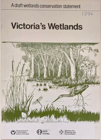
Book - Victoria's Wetlands, Dept. of Conservation, Forests & Lands, 1986
... Wetland protection Wetlands Victoria Water Conservation ...This publication was the result of an inquiry into the state of wetland environments in Victoria. It produced a draft strategy for conservation of threatened areas in the future.An 22 page book containing maps and illustrationsThis publication was the result of an inquiry into the state of wetland environments in Victoria. It produced a draft strategy for conservation of threatened areas in the future.wetland protection, wetlands victoria, water conservation -
 Wodonga & District Historical Society Inc
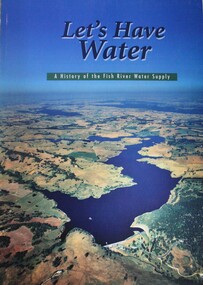
Book - Let's Have Water - A history of the Fish River Water Supply, Robin McLachlan, Denis Barrett, Jack Domis, Nick Welling, 1997
A history of the development of the management of the Fish River Water Supply Scheme in Central NSW. The scheme extends across the local government areas of the Shire of Oberon, the City of Lithgow and the City of the Blue Mountains.non-fictionA history of the development of the management of the Fish River Water Supply Scheme in Central NSW. The scheme extends across the local government areas of the Shire of Oberon, the City of Lithgow and the City of the Blue Mountains.water nsw, fish river region nsw, oberon dam, water resources development nsw australia -
 Port Melbourne Historical & Preservation Society
Booklet, State Government of Victoria, Making the Most of the Bay, 1990
Making the Most of the Bay - Plan for the protection and development of Port Phillip and Corio Bays, November 1990. An A4 booklet considering environment, land use and settlement, recreation and tourism, coastal and marine industries. Detailed recommedations for specific areas and foreward by Ministers Steve Crabb and Andrew McCutcheon (ref. item 1414, draft version)state government victoria, natural environment - conservation -
Lakes Entrance Historical Society
Book, Butler Graeme, New Works Conservation Analysis, 1993
Analysis of the engineering works, buildings and landscape surrounding the creation of the new artificial entrance at Cunninghame. This report defines a policy for the New Works area, as defined by the Historic buildings Council designation, and includesheritage, conservation, engineering, buildings -
 Eltham District Historical Society Inc
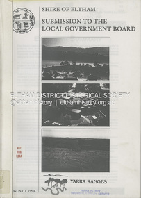
Book, Shire of Eltham, Submission to the Local Government Board: Yarra Ranges, 1 August 1994
A restructure proposal by the Shire of Eltham, named the municipality of Yarra Ranges, reflects a strategic focus. It has natural boundaries and a strong sense of place built on communities of interest. Prepared in consultation with the community and neigbouring municipalities of Diamond Valley and Heidelberg. Contents include: Principles for change, rationale for the proposal, mergers and other restructure proposals. Appendices include: community consultation, Metropolitan Green Wedge Strategy, Constituent Council Benchmark, external refernce benchmark - Moreland, communities of interest, conservation and landcare groups, social profile, key financial management strategies and more.54 pages, 11 Appendicesnon-fictionA restructure proposal by the Shire of Eltham, named the municipality of Yarra Ranges, reflects a strategic focus. It has natural boundaries and a strong sense of place built on communities of interest. Prepared in consultation with the community and neigbouring municipalities of Diamond Valley and Heidelberg. Contents include: Principles for change, rationale for the proposal, mergers and other restructure proposals. Appendices include: community consultation, Metropolitan Green Wedge Strategy, Constituent Council Benchmark, external refernce benchmark - Moreland, communities of interest, conservation and landcare groups, social profile, key financial management strategies and more.local government, municipal restructuring, council amalgamation -
Lakes Entrance Historical Society
Book, Land Conservation Council Victoria, Final Recommendations Gippsland Lakes hinterland Area, 1983
... Area Book Land Conservation Council Victoria ...1980 report and recommendations of the Victorian Land Conservation Council, for the balanced use of public land in teh gippsland Lakes Hinterland includes reserves schools forests rivers foreshores and other public sites. Map and diagrams added.topography, parks, waterways -
Lakes Entrance Historical Society
Book, Land Conservation Council Victoria East Gippsland Study Area, 1974
Report describing the nature of environmental features, together with the character and distribution of various natural resources of the East Gippsland, Victoria, study area, comprising land in the old Shire of Orbost. History, vegetation, flora, fauna,vegetation, natural history, vegetation -
Lakes Entrance Historical Society
Book, Land Conservation Council Victoria, Land Conservation Council East Gippsland Area Review, 1985
... Land Conservation Council East Gippsland Area Review... Gippsland Area Review Book Land Conservation Council Victoria ...Report describing the physical and biological aspects of the public land in the eastern corner of Victoria, predominantly the Orbost Shire. Many issues are covered in the report, including timber industry, national parks, waterways and tourism. Six mapsparks, waterways, tourism, gippsland -
 Bacchus Marsh & District Historical Society
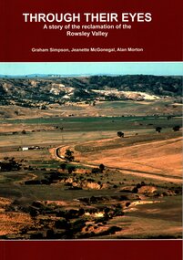
Book, Through Their Eyes : A Story of the Reclamation of the Rowsley Valley
This book contains a collection of articles written by landholders, local residents and members of corporate and volunteer organisations describing their roles in the restoration of Rowsley Valley. The historical scope of this book encompasses the geological and environmental history of the area prior to human habitation, occupation by the Wadawurrung people prior to European colonisation, and the colonial and post colonial eras. This introductory contextual background is complemented by the rest of the book which describes the various aspects of the environmental restoration of the Rowsley Valley from the latter part of the 20th century continuing to the present day.Printed foolscap size book. Softcover. 112 pages. Colour and black and white photos. Maps, figures, tables. Index. Publication details. Graham Simpson (Publisher, Bacchus Marsh, Victoria, 2021. Lead authors Graham Simpson, Jeanette McGonegal and Alan Morton.This book contains a collection of articles written by landholders, local residents and members of corporate and volunteer organisations describing their roles in the restoration of Rowsley Valley. The historical scope of this book encompasses the geological and environmental history of the area prior to human habitation, occupation by the Wadawurrung people prior to European colonisation, and the colonial and post colonial eras. This introductory contextual background is complemented by the rest of the book which describes the various aspects of the environmental restoration of the Rowsley Valley from the latter part of the 20th century continuing to the present day.environmental restoration projects, rowsley valley victoria environmental history, conservation of natural resources, aboriginal australians bacchus marsh region history, wadawurrung people history -
 Federation University Historical Collection
Book, Final recommendations Ballarat Study Area Land Conservation Council, Victoria, 1982, 1982
... Final recommendations Ballarat Study Area Land Conservation..., Roadside conservation and Highway parks, Education areas and School ...Yellow soft covered report of 95 pages . The contents of the report include: Parks, reference areas, wildlife reserves, water production, harwood production, softwood production, flora Reserves and Flora and Fauna reserves, bushland reserves, historic area and reserves, rivers and streams, Roadside conservation and Highway parks, Education areas and School Plantations, Lake Reserves, geological reserves, recreation, scenic reserves, agriculture, mineral and stone production, utilities and survey, township land, Uncommitted Land, military training, other reserves and public land. Maps include: The Study area 1: 250 000 Supplementary Mapsland conservation authority, ballarat, endowment plantations, pine plantations, langi ghiran state park, mount buangor state park, enfield state park, ballarat-creswick regional park, rossbridge, black lake, flax mill swamp, dereel lagoon, lake bolac, lake wongan, langi ghiran reservoir, gong gong reservoir, pincotts reservoir, beales reservoir, wilsons reservoir, moorabool reservoir, korweinguboora, korweinguborra reservoir, learmonth bores, sago hill, illabarook reservoir, ballarat water commission, dunneworthy, mount cole, mont lonarch, ben major, waterloo, trawalla, linton, ross creek, canadian, shepherds flat, lal lal, mount doran, raglan, chute, carngham, buninyong, watsons hill, enfield, cape clear, illabrook, rokewood junction, mount warrenheip, nerrina, jubilee, golden stream, australasian deep lead mine, happy valley school, piggoreet, berringa, bulldog, ballarat common, wildlife, water, timber, flora, rivers, geology, agriculture, warrenheip, biodiversity -
 Eltham District Historical Society Inc
Photograph - Digital Photograph, Alan King, Kinglake National Park, 27 March 2008
Fern gullies around Jehosaphat Gully Covered under National Estate. Published: Nillumbik Now and Then / Marguerite Marshall 2008; photographs Alan King with Marguerite Marshall.; p125 The magnificent Kinglake National Park, fringing Nillumbik’s north, is the largest national park close to Melbourne. Thanks to the vision and hard work of a band of local people, the park was created from what was rapidly becoming degraded land. Seeing a threat to Kinglake’s indigenous flora and fauna, several prominent local people campaigned for a national park, which was established in 1928.1 Since then, the park has grown through donations and acquisitions of land, from around 13,800 acres of land (5585ha) to 22,360 hectares. The Sugarloaf and Everard Blocks – of almost 8000 hectares – stand in Nillumbik and the park extends into Mitchell and Murrundindi Shires and the City of Whittlesea. Mt Everard commemorates William Hugh Everard, State member for Evelyn when the park was established. Before 1928, European settlers had degraded the Kinglake area, which was named after the celebrated English author and lawyer, Alexander William Kinglake. Remains of gold shafts and diggings in the park are reminders of Kinglake’s first settlers, who hoped to strike it rich at the gold diggings. But like other gold fields in this shire, they proved not very lucrative and soon timber cutting replaced mining in importance. However, before long, the accessible timber supply ran out, so in the 1920s agriculture took over – particularly potatoes and berry fruits – which involved large-scale clearing.2 The park’s instigator was retired Melbourne University Professor of Music, William Laver.3 As chair of the Kinglake Progress Association he began negotiations to have crown lands on the southern scarp of the Great Dividing Range reserved as a national park. Even before the park was proclaimed, from 1927, KPA members cut tracks to the major scenic points. Professor Laver was one of several people who gave land for the park, donating around 50 acres (20ha), including the Jehosaphat Gully.4 Laver chaired the park’s first Committee of Management, which raised money to employ a ranger and provide facilities, including tracks and roads for fire protection vehicles, toilets and shelters. The committee charged fees for firewood collection, some grazing of livestock, and visitor entrance, and obtained small State Government and Eltham Shire grants. In 1957 the State Government provided revenue for national parks. Then, in 1975, the State Government took over the management and the Committee of Management became an advisory committee, which disbanded in 1978. Originally, the park covered crown land in the Shires of Eltham and Whittlesea; then Wombelano Falls in Yea and other areas were added. In 1970 the park extended into the Shires of Eltham, Healesville, Whittlesea and Yea.5 Bush fires have been an ongoing problem. In 1939 hundreds of eucalypts and acacias had to be sown around the Jehosaphat Gully to rejuvenate the forest. To manage bushfires, the Committee of Management, then the State Government, worked closely with the Forestry Commission, shire councils and local fire brigades. Early national parks focussed on recreation. But by the 1980s, conservation, education and scientific research became more important, playing a vital role in preserving representative samples of the natural environment. Each year many thousands of people use the park’s extensive network of walking tracks amongst the protected plant and animal life as well as camping, cycling and horse riding. The park, along the slopes of the Great Dividing Range, has lookouts revealing magnificent views of the Melbourne skyline, Port Phillip Bay, the Yarra Valley and the You Yangs. Vegetation in the Masons Falls area includes messmate forest, Austral grass-trees, ferns and Hazel Pomaderris. In spring, orchids, lilies, everlasting daisies, correas, grevillea and heath appear. Around Jehosaphat Gully are wet and dry forest, fern gullies and banksia. Animal life includes wallabies, kangaroos, koalas, echidnas, possums, gliders and bandicoots. Male lyrebirds can be heard mimicking in the Jehosaphat Gully, particularly in the Everard Block in winter.This collection of almost 130 photos about places and people within the Shire of Nillumbik, an urban and rural municipality in Melbourne's north, contributes to an understanding of the history of the Shire. Published in 2008 immediately prior to the Black Saturday bushfires of February 7, 2009, it documents sites that were impacted, and in some cases destroyed by the fires. It includes photographs taken especially for the publication, creating a unique time capsule representing the Shire in the early 21st century. It remains the most recent comprehenesive publication devoted to the Shire's history connecting local residents to the past. nillumbik now and then (marshall-king) collection, kinglake national park, jehosaphat gully -
Darebin Parklands Association
Interview by Reg Johnstone of Laurence J. Course, 5th November 1976, Laurie Course, 1976
Audio recordings, including a recording of a radio interview (approximately 12 minutes) in which Laurie Course discusses the early history of the Rockbeare Park; the significance of the area; and plans to develop the area into the Darebin Parklands.Audio tape. This item and all other Darebin Parklands Association archival material is now held by State Library Victoria (Accession No: YMS 13746). Please contact State Library Victoria if access is required.Covered with cardboard sleeve wth annotation that incluces: [Interview by Reg Johnstone of Laurence J. Course of the Rockbeare Park Conservation Group at 1.30 in the Hardware Lane Studio in Cyclone House & was broadcast on 3ZZ at 8.15 that night on Friday 5th November 1976]. Annotations also on tape itself. -
 Eltham District Historical Society Inc
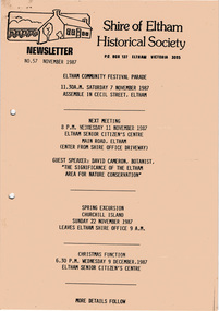
Newsletter, Newsletter, No. 57 November 1987
... , Botanist: The significance of the Eltham area for nature..., Botanist: The significance of the Eltham area for nature ...Contents: • Next meeting, guest speaker; David Cameron, Botanist: The significance of the Eltham area for nature conservation • Eltham Community Festival • November Meeting • Churchill Island Trip • Christmas Break-up • Twentieth Anniversary Functions • Other Brief Items The Shire of Eltham Historical Society was formed in October 1967. The first newsletter of the Society was issued May 1978 and has been published continuously ever since on a bi-monthly basis. With the cessation of the Shire of Eltham in late 1994, the Society's name was revised to Eltham District Historical Society and this name first appeared with issue No. 103, July 1995. The collection of the Society's newsletters provides a valuable resource on the history of the Society's activities, office bearers and committee members, guest speakers and subjects of historical interest pertinent to the former Shire of Eltham and the Eltham District.A4 photocopied newsletter distributed to membersnewsletter, eltham district historical society, shire of eltham historical society -
 Bendigo Historical Society Inc.
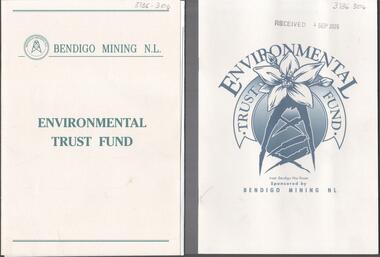
Booklet - Kangaroo Flat Gold Mine Collection: Environmental Trust Fund Policy booklet
The Bendigo Environmental Trust was established in 1995 with funds provided by Bendigo Mining NL. The Trust was administered by an honorary Board of Trustees. Preference was given to projects that reflected the philosophy of the Bendigo Region Conservation Strategy, namely flora and fauna, energy conservation, land and water protection and waste management. Two copies of an eight page booklet titled ' Environmental Trust Fund, sponsored by Bendigo Mining NL. One booklet date stamped 4 Sep 2002. Content identical in both: policy; how the Bendigo ining Environmental Trust works; who can apply; areas supported; how to apply; preferred format; limitations of grants; support period; when to apply, where to apply and project documentation required.Date stamp September 2005 on one copy.bendigo mining nl, environment, environmental trust, flora and fauna, energy conservation, waste management, land and water protection, kangaroo flat, goldmining -
Lakes Entrance Historical Society
Book, Land Conservation Council, Victoria, East Gippsland Area Review Final Recommendations Land Conservation, 1986
Report describing the physical nature of the East Gippsland area (Victoria) study area. History, climate, geomorphology, land use, flora and fauna are presented. Map included.topography, land settlement -
 Whitehorse Historical Society Inc.
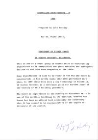
Document - Report, Conservation analysis of 18 Gordon Crescent, Blackburn, 1995
18 Gordon Crescent Blackburn. A conservation analysis undertaken by Lois Routley for Dr Miles Lewis, Lecturer in Architecture. For titles accompanying this study see A-SP-T 13,A-SP-T 14, A-SP-T 15, A-SP-T 16. Includes detailed history of development of the area and occupants of the house.gordon crescent, blackburn, no.18, land subdivision, lewis, miles, woods, john, coppin, george seth, freehold investment and banking company of australia ltd, wolseley crescent, blackburn, blackburn, quarterman, martha, clarke, arthur e, game, kate, t. r. b. morton & son., game, thomas robinson, urquhart, finlay, newman, jeffrey william forbes, newman, valerie, jones, ian, jones, joan, strickland, kenneth william, strickland, wilma dawn -
Villa Alba Museum
Document, Andrew Thorn, Villa Alba: Condition Survey and Stabilization of Critical Surfaces, 1997
This report was commissioned by the Villa Alba Preservation Committee following evidence of deterioration on a number of important surfaces at Villa Alba. The report documents changes that have occurred and compares them to the situation reported on in 1986. The report then outlines treatments carried out in 1986 and recently for each of the rooms worked on in 1986.36-page conservation report conducted by Andrew Thorn (Artcare) in 1997 of surfaces in Villa Alba. The report has the following structure: Condition Survey, Treatment Materials and Methods, Detailed Work in Each Room. This copy of the draft report includes detailed plans showing areas requiring stabilization.This report was commissioned by the Villa Alba Preservation Committee following evidence of deterioration on a number of important surfaces at Villa Alba. The report documents changes that have occurred and compares them to the situation reported on in 1986. The report then outlines treatments carried out in 1986 and recently for each of the rooms worked on in 1986. villa alba museum, conservation reports, andrew thorn, artcare, conservation treatments -
 Eltham District Historical Society Inc
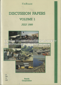
Book, VicRoads, Discussion Papers Volume 1, July 1989
VICROADS Discussion papers address key issues that have been identified by the community, through regional workshops, as having particular significance in determining the direction that should be taken in managing the rural arterial road system in Victoria to the year 2000. Volume One consists of the following discussion papers: road safety, rural development, conservation and the environment, future rural transport task and traffic in towns.non-fictionVICROADS Discussion papers address key issues that have been identified by the community, through regional workshops, as having particular significance in determining the direction that should be taken in managing the rural arterial road system in Victoria to the year 2000. Volume One consists of the following discussion papers: road safety, rural development, conservation and the environment, future rural transport task and traffic in towns.roads, vicroads, rural areas, road safety, rural development, conservation, traffic -
Lakes Entrance Historical Society
Book, Land Conservation Council, Victoria, Final Recommendations East Gippsland Study Area 1977, 1977
... Gippsland Study Area 1977 Book Land Conservation Council, Victoria. ...A summary of the final recommendation for the adequate management and protection of public land in East Gippsland.natural resources, recreation, agriculture -
Lakes Entrance Historical Society
Book, Land Conservation Council Victoria South Gippsland Area District 2, 1980
Report describing and assessing the natural resources of the public land in the South Gippsland (Victoria) Study Area 2, comprising the Latrobe Valley, Strzelecki Range, South Gippsland coastal plains and all of Wilson's Promontory. History, Geology, floRuth Clarkgippsland, topography, natural history, vegetation -
Lakes Entrance Historical Society
Book, Land Conservation Council Victoria Alpine Area, 1977
... Land Conservation Council Victoria Alpine Area... Conservation Council Victoria Alpine Area Book ...Report containing information from various sources relevant to the future use of public land in the alpine area of Victoria. History, climate, landform, vegetation, land use, are some of the aspects presented.Ruth Clarktopography, vegetation -
Lakes Entrance Historical Society
Book, Land Conservation Council Victoria Gippsland Lakes Hinterland Area, 1982
Report describing the physical nature of the land in the Gippsland Lakes (Victoria) Hinterland Study area. History, climate, geomorphology, land use, flora and fauna are presented. 1 map in pocket.waterways, gippsland, natural history, vegetation -
 Eltham District Historical Society Inc
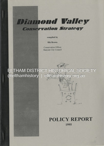
Book, Richard E. G. Brown, Diamond Valley Conservation Strategy: Policy Report, 1995
The Diamond Valley Conservation Strategy will be used by Nillumbik and Banyule councils when developing conservation policies. The strategy was developed by the former Shire of Diamond Valley and documents environment and heritage values and possible threats to those values of the former Shire and policy aims and objectives. This report documents flora and fauna conservation, heritage conservation, landscape conservation, sustainable land use, conservation of resources, waster management and community education and involvement. The Shire of Diamond Valley (1964-1994) was abolished in May 1994. Areas merged with the newly created Shire of Nillumbik, City of Banyule and City of Whittlesea.27 p.non-fictionThe Diamond Valley Conservation Strategy will be used by Nillumbik and Banyule councils when developing conservation policies. The strategy was developed by the former Shire of Diamond Valley and documents environment and heritage values and possible threats to those values of the former Shire and policy aims and objectives. This report documents flora and fauna conservation, heritage conservation, landscape conservation, sustainable land use, conservation of resources, waster management and community education and involvement. The Shire of Diamond Valley (1964-1994) was abolished in May 1994. Areas merged with the newly created Shire of Nillumbik, City of Banyule and City of Whittlesea.environmental policy, environmental protection, shire of diamond valley -
 Eltham District Historical Society Inc
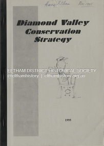
Book, Richard E. G. Brown, Diamond Valley Conservation Strategy, 1995
The Diamond Valley Conservation Strategy, compiled by Rik Brown, Conservation Officer, Banyule City Council will be used by Nillumbik and Banyule councils when developing conservation policies. The strategy was developed by the former Shire of Diamond Valley and documents environment and heritage values and possible threats to those values of the former Shire and policy aims and objectives. The Shire of Diamond Valley (1964-1994) was abolished in May 1994. Areas merged with the newly created Shire of Nillumbik, City of Banyule and City of Whittlesea.non-fictionThe Diamond Valley Conservation Strategy, compiled by Rik Brown, Conservation Officer, Banyule City Council will be used by Nillumbik and Banyule councils when developing conservation policies. The strategy was developed by the former Shire of Diamond Valley and documents environment and heritage values and possible threats to those values of the former Shire and policy aims and objectives. The Shire of Diamond Valley (1964-1994) was abolished in May 1994. Areas merged with the newly created Shire of Nillumbik, City of Banyule and City of Whittlesea.shire of diamond valley, conservation, environmental policy, strategy -
University of Melbourne, Burnley Campus Archives
Plan, Horticultural Project Conservation and Management Plan Wombat Park, 1994
Photocopies of plan drawn by M. Gilbert of Survey Area C-G, with numbered plant list. (Miffy Gilbert's final thesis, 1994, Conservation Analysis & Management Plan Wombat Park Daylesford - see AGHS website)m. gilbert, wombat park, management plan, daylesford, gardens, plant list