Showing 3431 items matching "distance"
-
 Hume City Civic Collection
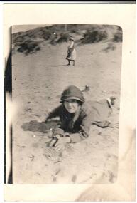
Photograph, 1920s
A copy of a snapshot of a woman lying on the sand. She is wearing a hat and coat. Another woman is in the middle distance and is half turned towards the camera. There are sand dunes in the background.headwear, 1920s, george evans collection -
 Hume City Civic Collection
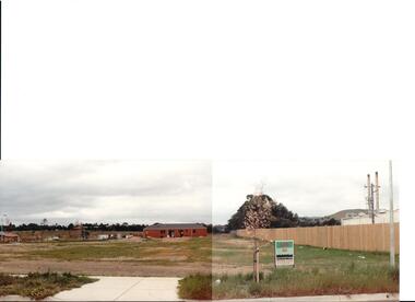
Photograph, early 1990s
The series of 5 photographs feature different views of the Woodlands housing development which opened up land bounded by Gap and Anderson Roads, Cornish Street and Elizabeth Drive in the early 1990s. It was a large housing development built close to Sunbury township.A coloured photograph of a new housing development taken in Anderson Road looking west towards Elizabeth Drive and the leisure centre. Some housing construction is in the middle distance.housing developments, anderson road, george evans collection -
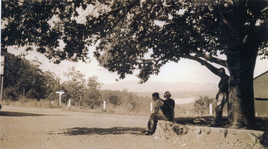 Mt Dandenong & District Historical Society Inc.
Photograph, FiveWays, Kalorama Looking Towards Silvan Dam, c1930
Close up of elm tree at FiveWays with a man and woman seated on stone bank and a man standing under the tree. Silvan Dam visible in distance. (2 copies)fiveways, kalorama, silvan dam -
 Kew Historical Society Inc
Photograph - Second Johnston Street Bridge in Flood, 1934
Original, small black and white print photograph of crowds lining the Johnston Street Bridge watching the flood waters below. The annotation on the reverse clarifies that Kew is in the distance.Annotated on reverse: "Gift of G.S. Beard / 2nd bridge / Johnston St. Studly Park Rd. Bridge looking towards Kew / 1st bridge 1858–1876, 2nd bridge built (bad bend), 1876–1958, 3rd bridge 1958, lined up Johnston St and Studley Park Rd."johnston street bridge, bridges - yarra river -- kew (vic.), flood -- 1934 -
!['Reno', St John's Parade [Kew]](/media/collectors/550653872162f11fb04854aa/items/658d16120f23e8f1e738df53/item-media/658d16680f23e8f1e738e098/item-fit-380x285.jpg) Kew Historical Society Inc
Kew Historical Society IncPhotograph - 'Reno', St John's Parade [Kew], c. 1965
‘Reno’, stood on the east side of St John’s Parade. Its earliest recorded owner was the architect Samuel Cocking who lived there from c.1865 until his death in 1888. The original landholding was bordered by Cotham Road, Glenferrie Road, Wellington Street, and Charles Street. The garden including rare plants supplied by Baron Von Mueller, surrounds the cottage in a tangled frenzy. Despite a ‘local significance’ classification by the National Trust, the house was demolished in 1977.This work forms part of the collection assembled by the historian Dorothy Rogers (1905-1973), donated to the Kew Historical Society by her son in 2015. The manuscripts, photographs, maps, and documents were sourced by her from both family and local collections or produced as references for her print publications. Many were directly used by Rogers in writing ‘Lovely Old Homes of Kew’ (1961) and 'A History of Kew' (1973), or the numerous articles on local history that she produced for suburban newspapers. Most of the photographs in the collection include detailed annotations in her hand. The Rogers Collection provides a comprehensive insight into the working habits of a historian from the 1960s to the 1970s. Original monochrome photograph of Reno, St John's Parade, Kew. Pictured are the garage in the distance at left, the weatherboard house with its simple verandah, and the overgrown front garden.Annotation verso: "Reno. St Johns Parade. Reno. Miss Green".dorothy rogers, reno.-- st john's parade (kew) -
 Kew Historical Society Inc
Photograph, Colin Campbell, The Old Gum Tree, 1961
In 1871, Victoria Park, beside the Boroondara General Cemetery was set aside as a public reserve. As the Park developed, exotic plants were added to existing specimens. In 1910, a photograph of ‘The Oldest Inhabitant: A Giant Red-gum Tree’ in the Park was included in the Jubilee History of Kew. Fifty-one years later the tree was re-photographed by Colin Campbell. A 2007 Master Plan developed for the City of Boroondara advises the retention of this now dead River Red Gum, including a ‘managed risk zone’ and planting under the heavily lopped tree.‘The Old Gum Tree’ in Victoria Park. In the distance a game of cricket is being played on the oval. The old grandstand can be seen in the photo. Photographer Colin Campbell 1961. THE OLD GUM TREE / COLIN CAMPBELL KEW 1961victoria park (kew), colin campbell (photographer), victoria park, red gum tree, eucalypts, kew (vic.) -- historic trees -
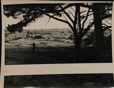 Kew Historical Society Inc
Photograph - Urban landscape, 1860
An item from an outstanding and diverse photographic collection, assembled by members of the Christian and Washfold families of Kew.Black and white photograph of man standing underneath large conifers looking across a valley to buildings in the distance. Similar locations in nos.41, 42, 43, 44.christian-washfold collection, landscape photography, subdivisions -- kew (vic.) -
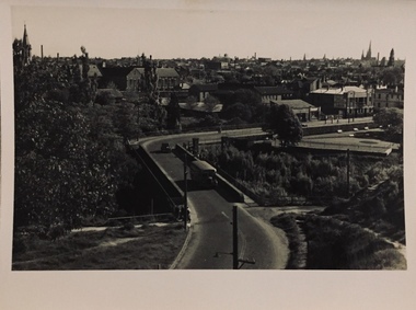 Kew Historical Society Inc
Photograph - Johnston Street Bridge, 1952
An item from an outstanding and diverse photographic collection, assembled by members of the Christian and Washfold families of Kew.Johnston Street Bridge before new bridge constructed. Bus on bridge, Abbotsford Convent on left and Melbourne skyline in distance. St Ignatius, Richmond without steeple. -
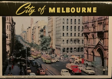 Kew Historical Society Inc
Postcard, John Sands Pty Ltd, City of Melbourne
One of a number of 'real photo' and commercial postcards created by or owned by members of the Christian and Washfold families of Kew. The postcards are part of a larger collection of photographs, postcards and publications donated to the collection in May 2021.Colour concertina postcards of Melbourne showing the intersection of Queen and Collins Streets looking east to the T&G Building in the distance. Series of concertina postcards of the City of Melbourne.postcards -- melbourne (vic.), christian-washfold collection -
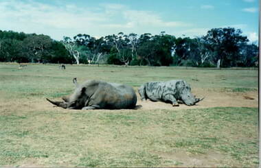 Sunbury Family History and Heritage Society Inc.
Photograph, Werribee Park Open Range Zoo, c1989
The children from Bulla Primary School were taken on an excursion to Werribee Mansion and Open Range Zoo as part of their nature and environmental studies. On that day they saw a variety of exotic animals that inhabit open savannah areas.The excursion was included in the students' environmental and nature studies.A non-digital photograph of two large rhinoceros lying in a large sand pit in a large fenced off enclosure with trees in the middle distance beyond the fence line.werribee park open range zoo, werribee mansion, bulla primary school, school excursions -
 Sunbury Family History and Heritage Society Inc.
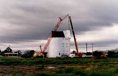
Photograph, Wheat silo
The wheat silo was erected on railway land on the west side of the railway line at Sunbury from approx 1970s - 1980s. It served as a grain storage provision for the local cereal farmers.The former CFA depot which was in Evans Street. With the expansion of the shopping centre the silo was dismantled to provide commercial development on the west side of the railway line.The wheat silo is a reminder of past agricultural industries that were carried out in Sunbury.A non-digital photograph of two trucks and a crane dismantling a metal wheat silo, which has been standing in an open area. A CFA pavilion is visible in the distance.wheat storage, silos, sunbury railway station, evans street -
 Sunbury Family History and Heritage Society Inc.
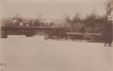
Photograph
The post card is a record of a time when the Jacksons Creek flooded and the water almost reached the two arches on the Macedon Street Bridge. The Goonawarra Winery buildings can be seen in the back ground.A sepia photograph in post card format of a river in flood with the water almost reaching the two arches on the stone bridge. Farm buildings can be seen in the middle distance.JACKSON'S CREEK IN FLOOD SUNBURYmacedon street bridge, jacksons creek, goonawarra winery -
 Lakes Entrance Historical Society
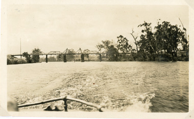
Photograph - Bridges, 1925
Photo taken same year Swan Reach bridge collapsed 16 November 1925Black and white photograph of the lifting bridge over the Tambo River taken from the stern of a boat. A tourist launch under the bridge in distance. Swan Reach Victoriabridges, waterways -
 Lakes Entrance Historical Society
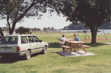
Photograph - Eastern boat ramp Lakes Entrance Victoria, LE Tidy Town Committee, 1994 c
Colour photograph of picnic area adjacent to Eastern boat ramp on North Arm, old concrete bridge over North Arm in distance Lakes Entrance Victoriarecreational facilities, boat ramp, gippsland lakes, parks -
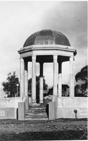 Stawell Historical Society Inc
Photograph, Pioneers’ Memorial on Big Hill -- 3 Photos
Three black and white photos of Pioneers Memorial Stawell. The larger of the 4 photos is a Post card and taken earlier than the other 3 photos as there is a plastic milk crate over the area where the direction indicator was later placed. This photo also has "Chapman photo Stawell" stamped on the print. Two of the smaller photos show the Pioneer Memorial at a distance with people standing between the memorial and a bus parked to the left of the photograph. One of these two photos has a white seat on the right side. The fourth photo has "Murray View No. 8 Pioneers' Memorial, Stawell Vic". printed on the photograph of the Pioneers' Memorial. Each of the these 3 smaller photos have the direction indicator under the dome.Three black and white photos of Pioneers Memorial Stawell. The larger of the 3 photos is a Post card taken earlier than the other 2 photos as there is a plastic milk crate over the area where the direction indicator was later placed. This photo also has "Chapman photo Stawell" stamped on the print. Two of the smaller photos show the Pioneers' Memorial at a distance with people standing between the memorial and a bus parked to the left in the photograph. One of these two photos has a white seat on the right side. Each of the 2 smaller photos have the direction indicator under the dome.Chapman Photo Stawell (right bottom corner). Post Card printed on the back and also a stamp "Stawell district - Pioneer's Memorial - written inside the stamp is "Every blade of grass that grows And mullock heap and tree, Speak of Old days, the Good days, And times that used to be"stawell -
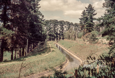 Eltham District Historical Society Inc
Photograph, Russell Yeoman, Maroondah Aqueduct, Research, c.1979, 1979c
Looking west, The Esplanade to the right and Ingrams Road Bridge in centre distance. Digital file only; created from original colour positive slide transparencymaroondah aqueduct, research (vic.), ingrams road, the esplanade, russell yeoman collection -
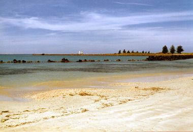 Port Fairy Historical Society Museum and Archives
Photograph
East beach near battery hill sails of a tall ship in distance Coloured photograph of the East Beach with the lighthouse and a tall ship in the backgroundeast beach, ship, ocean, sea -
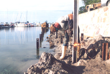 Lakes Entrance Historical Society
Photograph, Lakes Post Newspaper, Boardwalk Project Metung Victoria 1999, 1/02/1999 12:00:00 AM
Boats moored at marina in distance and Metung Rock beside planned boardwalkColour photograph showing Tim Edwards from Burys Slipway working on the foundations for the Boardwalk Project beside the lake at Metung Victoriawaterways, community organisation -
 Lakes Entrance Historical Society
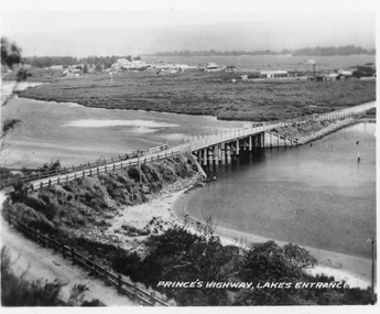
Postcard - North Arm bridge Lakes Entrance Victoria, 1920c
Also 2x identical fade P)1151-2,3Black and white miniature postcard of the concrete bridge spanning the North Arm, showing the bridge and abutments,road to bridge from Kalimna, and post and rail fences along road, grass covered mud flats with Club Hotel, Methodist Church and Maranui Guesthouse in distance amongst other buildings. Cunninghame Arm and sand hummocks in far distance. Sandbars visible in North Arm. Lakes Entrance VictoriaPrincess highway Lakes Entrancebridges, coast, religion, hotels, guesthouses -
 Falls Creek Historical Society
Poster - Kangaroo Hoppet 2016
The Kangaroo Hoppet is Australia’s premier long distance cross country ski race, and a member of the Worldloppet series of international cross country ski events. The first race at Falls Creek was held in 1979 under the name of “Australian Birkebeiner”. It was a 21km race with about 80 participants organised by the Birkebeiner Nordic Ski Club of Mount Beauty. The course started and finished at Falls Creek Alpine Resort and took participants out into the Bogong High Plains. After running the event for 10 years, it was decided they should become part of the Worldloppet series of marathon ski races. Representatives from the Birkebeiner Nordic Ski Club and the Australian Ski Federation attended the Worldloppet Annual Meeting in Finland in June 1990 to put the case for the acceptance of an Australian event into the Worldloppet series. Before being admitted, they had to demonstrate that the Birkebeiner Club could run a world class event, so three months later in August 1990 a 42km event named the Australian International Ski Marathon was held at Falls Creek together with a 21km Birkebeiner race and a 7km event called the Birkebeiner Lite. The event was approved by delegates from USA, Norway and Austria, in 1991 Australia became the 12th member of Worldloppet, with the condition that there had to be a name change. After some late night discussion allegedly involving red wine from North East Victoria the main event became the 42km Kangaroo Hoppet, with the minor events being the 21km Australian Birkebeiner, and 7km Joey Hoppet. In the winter of 1991, the first Kangaroo Hoppet was held. It was a great success and has been a regular fixture on the international ski calendar ever since. It features the main 42km event as well as a 21km event and a 7km event. The Hoppet brings the Australian snowfields to an international audience. In 2016 the Men's Winner was Matthew Gelso from USA in a time of 1:53:23.1. The winner of the Women's event was Deedra Irwin of USA in a time of 2:08:15.6. This poster is significant because it documents an event which brings international attention to Falls Creek and the surrounding region.A poster featuring two skiers crossing gentle slopes passing a tree on the right. There is a line of international flags flying overhead and the outline of two kangaroos in the distance. Logos of Worldloppet, AGL, Falls Creek, Alpine Shire Council, Victorian State Government, the Birkebeiner Nordic Ski Club and FIS are across the bottom of the poster.Beside Kangaroo Hoppet yellow and black Road sign: KANGAROO HOPPET 26 27 August 2016 42 km 21 km 7 km Falls Creek Victoria Australia Below the logos: www.hoppet.com.au kangaroo hoppet, worldloppet events, falls creek, mt. beauty -
 Glenelg Shire Council Cultural Collection
Photograph - Photograph - Henty Beach Portland, Victoria, n.d
Back to Portland, Portland's 100th Anniversary, November 1934Black and white photo. Henty Beach, looking towards Fishermen's breakwater, navy ship in distance, people on beach. Back to Portland, Portland's 100th Anniversary, November 1934Back: '82' handwritten -
 Bendigo Historical Society Inc.
Photograph - RAVENSWOOD CROWN LANDS, c2003
large colour Photograph, Ravenswood Crown Lands, Photo shows 3 buildings which are part of Ravenswood Estate, among Peppercorn and Gum trees and rocky outcrops in the distance.photograph, building, ravenswood estate -
 Bendigo Historical Society Inc.
Photograph - PHOTOGRAPH COLLECTION: GROUP OF MEN, 1924
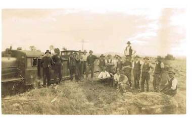
Photograph 2 - Sepia photo of a large group of men standing next to a train, in open country, power line seen in distance. Written on back 'Moolort October 1924.photograph, portrait, group, photograph, group of men, train, moolork. october 1924. -
 Bendigo Historical Society Inc.
Photograph - SOLDIERS MEMORIAL HALL BENDIGO
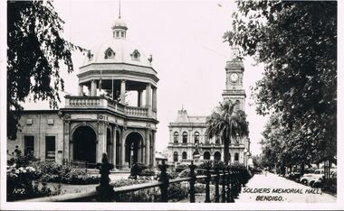
Photograph - black and white. Photograph of Soldiers Memorial Hall, Bendigo. Written on left hand corner No.2. Old Post Office in the distance. Palm tree near fence.buildings, government, soldiers memorial hall., soldiers memorial hall bendigo. -
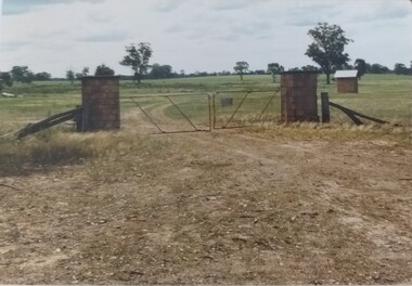 Tatura Irrigation & Wartime Camps Museum
Photograph, Camp 13 Main Entrance, 1989
Camp 13, Murchison, property owned by Jim Finnegan. German, Italian, Japanese prisoners held 1941-1946. Main entrance to Camp 13 Murchison.Camp 13 entrance gate, original stone pillars constructed using local stone, sentry box right mid -distance. Camp 13 Camp Road, Murchison. camp 13, pow, internment camps, murchison victoria, finnegan, japanese pows, german pows, italian pows -
Tatura Irrigation & Wartime Camps Museum
Photograph, Goulburn Weir, 1890
Taken by photographer for State Rivers and Water Supply Commission.Medium sized black and white photograph. Water flowing through opened weir gates - over spillway - weir structure mid-distance. Trees beyond on far bank.goulburn weir, victorian state rivers and supply commission -
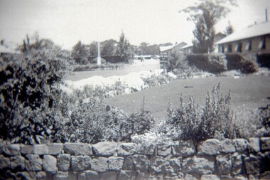 Tatura Irrigation & Wartime Camps Museum
Photograph, AWAS Quarters Garden
Photograph depicts the garden at the AWAS quarters at Camp 13 Murchison.Black and white photograph of a garden. Stone wall at bottom of the picture, flowers and lawn behind. Huts to the right. Left of centre is a flag pole with a hedge behind. Trees in distance.awas quarters, camp 13, murchison pow camp, camp gardens -
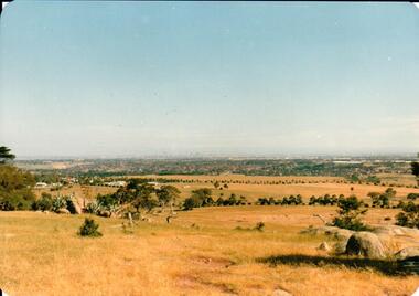 Hume City Civic Collection
Photograph, early 1980s
The Tullamarine Airport opened in 1970 and replaced Essendon Airport as Melbourne's main airport terminal. Gellibrand Hill was incorporated with Woodlands Park and became a public reserve during the 1980s.A coloured landscape photograph with rounded corners taken from Gellibrand Hill and overlooking the Tullamarine Airport which is on the RHS of the photograph. The Melbourne City skyline can be seen in the distance.gellibrand hill, tullamarine airport, melbourne skyline, george evans collection -
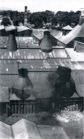 Whitehorse Historical Society Inc.
Photograph, Australian Tesselated Tile Co Pty Ltd
The Tesselated Tile company began in 1886 under the Wiseman brothers. At the beginning only bricks and stoneware pipes were manufactured. Mr E. E. Walker was engaged as manager and good progress was made until 1893 when the banks crashed. This business was a survivor and by the end of the 1890's the manufacture of tiles had begun. When the Wiseman brothers died in about 1907, E.E. Walker became the managing director.Black and white photograph of the Australian Tesselated Tile factory as seen from above. Pairs of chimneys in the foreground, and in the distance a tall chimney showing A T Tile Co in whiteaustralian tesselated tile co pty ltd, tile factories, edwards, edgars edwards -
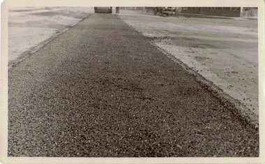 Kew Historical Society Inc
Photograph - Road works in the former City of Kew
One of a series of photographs donated by the City Engineer of the former City of Kew, relating to road works. The photos variably include council workers, signage and equipment.One of a series of photographs of core local government services as practised by the City of Kew. The photographs are an accurate record of street works of the period. Original black and white photographic positive of roadworks in the former City of Kew. This is a close up technical view of creating a bitumen and gravel road with the City's steam roller in the distance.city of kew, local government -- city of kew, road works, street works