Showing 14314 items matching "drives"
-
 Greensborough Historical Society
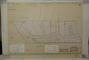
Planning document, Subdivision Plan #1009. Corner Allumba Drive and Beales Road Greensborough, 1981_
Plan of Subdivision of land at corner of Allumba Drive and Beales Road Greensborough.An example of hard copy subdivision plans from the Greensborough area. Mainly from the Shire of Diamond Valley era (1964-1994).Plan (2 sheets) mounted on heavy card.Stamped and handwritten Council permissions, dates and other details.subdivision plans, allumba drive, beales road -
 Greensborough Historical Society
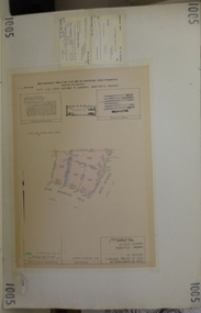
Planning document, Subdivision Plan #1005. Corner Douglas Court and Glen Katherine Drive Greensborough, 1981_
Plan of Subdivision. Corner Douglas Court and Glen Katherine Drive Greensborough.An example of hard copy subdivision plans from the Greensborough area. Mainly from the Shire of Diamond Valley era (1964-1994).Plan (2 sheets) mounted on heavy card.Stamped and handwritten Council permissions, dates and other details.subdivision plans, douglas court, glen katherine drive -
 Greensborough Historical Society
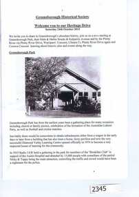
Booklet, Greensborough Historical Society: Heritage Drive 2015, 24/10/2015
On Saturday 24th October 2015, the Greensborough Historical Society Heritage Day included a walk or drive to the Plenty River heritage precinct, observing many heritage sites in the area. This booklet was prepared by GHS President Noel Withers for those choosing to drive the route. A map is included.16 pages, text and images (some col.).greensborough historical society, plenty river pioneer trail, noel withers -
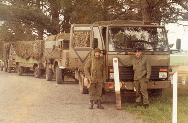 8th/13th Victorian Mounted Rifles Regimental Collection
Photograph
While many recruits could already drive when they joined 8/13 Victorian Mounted Rifles it took many hours of instruction and training before they were licenced to drive heavier, more complex army vehicles both on and off road and under combat conditions.Two colour photographs of two soldiers of ' A ' Squadron 8/13 Victorian Mounted Rifles, one holding a dislodged guide post. Line of trucks behind them. probably a driver training exercise. Corporal M. Roberts is wearing beret. -
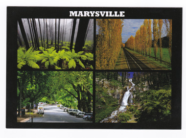 Marysville & District Historical Society
Postcard (item) - Colour postcard, Donovan Wilson, MARYSVILLE, Post 2009
A postcard with four colour photograph of attractions in an around Marysville in Victoria.A postcard with four colour photograph of attractions in an around Marysville in Victoria. This postcard was produced by Donovan Wilson as a souvenir of Marysville.Tree fern and Alpine Ash/ Goulds Memorial Drive/ Murchison St. Marysville/ Steavenson Falls Donovan Wilson Place/ Stamp/ Heremarysville, tree fern, alpine ash, goulds memorial drive, murchison street, steavenson falls, donovan wilson, postcard, souvenir -
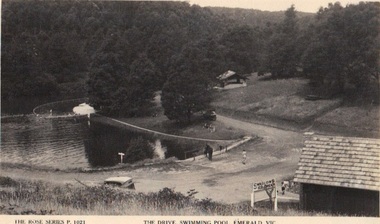 Emerald Museum & Nobelius Heritage Park
Photograph/postcard, The Rose Series P.1021 'The Drive, Swimming Pool, Emerald, Vic, circa 1930's - 40's
Emerald Park Lake - early photographEarly postcard depicting Emerald Park LakeFront: The Rose Series P.1021, 'The Drive, Swimming Pool, Emerald, Vic. Back:: Published by the Rose Stereograph Co. Armadale Victoriarose series, swimming pool, emerald park lake -
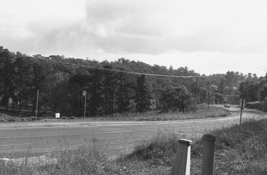 Ringwood and District Historical Society
Photograph, Warrandyte Road looking west from intersection with Old Warrandyte Road and Tortice Drive 1981
Written on back of photograph, "19/7/81. Warrandyte Road looking west from intersection with Old Warrandyte Road and Tortice Drive." -
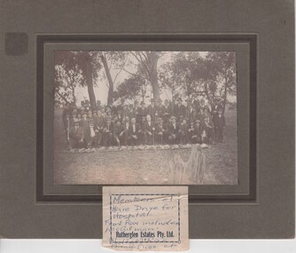 Rutherglen Historical Society
Photograph, 1920 (Approximate)
Rev. Watts in groupPhotograph of a group of men, seated & standing, with line of dead hares. Mounted. Unframed."Hare Drive For / Hospital / Front Row Includes / Les Gillman / Rutherglen Estates Pty Ltd / Walter McRae / Frank Fuge, etc."hare drive, les gillman, walter mcrae, frank fuge -
 Kew Historical Society Inc
Photograph - 'Merridale' (formerly 'Pomeroy'), 43 Sackville Street, 1979
In 1979, a series of photographs of significant gardens in Kew (Victoria) were taken during a tour by Peter Watts, of National Trust Victoria. These were later purchased to add to the collection. In the case of each photo the colour had badly degraded over time. Original colour (degraded) positive photograph of the front garden and part of the colonnaded verandah of 'Merridale' (formerly 'Pomeroy'), 43 Sackville Street, Kew.Annotated in ink reverse: "Merridale 43 Sackville St Built 1884/5 / View of drive to portico / Entrance old trees and gardens"merridale, pomeroy, sackville street -- kew (vic.), gardens -- kew (vic.) -
 Ringwood and District Historical Society
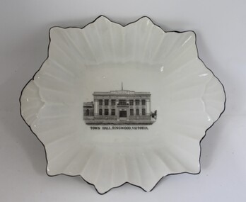
Souvenir - Small bowl, R K G, White china bowl, irregular shape with black edge around flutes with pen and ink drawing of the Ringwood Town Hall
Given by John J Johnson (763-9337), 18 Beckenham Drive, FTGWhite china bowl, irregular shape with black edge. Around flutes with pen and ink drawing of the old Ringwood town hall. +Additional Keywords: Johnson, John JTown Hall, Ringwood, Victoria.; On back: RKG - Made in CESHOSLOV -
 Greensborough Historical Society
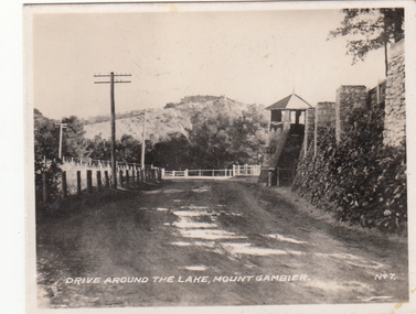
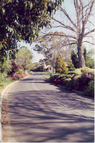
Photograph - Digital image, Charles Marshall et al, Mount Gambier tourist drive, 1920s
This photograph shows the tourist drive around the top of the Blue Lake at Mount Gambier.Digital copy of black and white photograph. This photograph has no captioncharles marshall, world war 1, mount gambier -
 Greensborough Historical Society
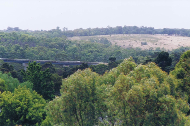
Photograph - Digital image, Frank Solomon, View over Greensborough to Plenty River Drive bridge, 2010c
View over trees to the Greensborough By-pass bridge over Plenty River Drive.Digital copy of colour photographplenty river drive, greensborough bypass -
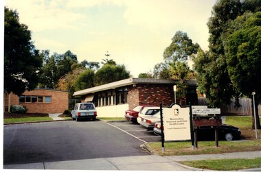 Whitehorse Historical Society Inc.
Photograph, Vermont South Maternal and Child Centre
The Vermont Maternal and Child Care Centre is situated in Karoboran Drive Vermont South.Coloured Photograph of a brick building with a council sign at the frontvermont south maternal and child centre, childrens services, maternal and child centres -
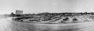 Stawell Historical Society Inc
Photograph, Stawell Drive-in Theatre in the Trotting Track in a panoramic view from the West c1960
Panoramic View of Stawell Drive-in Theatre & Trotting Track from west c1960 stawell entertainment -
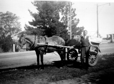 Linton and District Historical Society Inc
Photograph, Ted Cheeseman with Nicol's Baker's Cart, 1940
Gentleman identified as Ted Cheeseman who used to drive Nicol's baker's cart.Small B&W photograph of man wearing pullover standing beside horse and 2-wheeled baker's cart. Photo taken near Pioneer Memorial (R.H. side)."3956B Dave (Pud) Nicol".ted cheeseman, nicol's bakery, transport, workers, horse drawn vehicles, linton pioneer memorial -
 Stawell Historical Society Inc
Realia, Stawell Drive in Theatre Burger Bags 1980's
Stawell Drive In at the centre of current Trotting Track was there until around 1980's Red paper bags for HamburgersGreat Taste Plain Burger Village Roadshow Corporationentertainment -
Federation University Historical Collection
Photograph, Mount Helen Campus Buildings, c2003
.1) Former Art building at Mt Helen. In 2005 it was used by IBM. .2) Roundabout in Chancellor Drive, looking towards the Geoffrey Blainey Auditorium. .3) Peter Blizzard sculpture in front of the Geoffrey Blainey Auditorium. art building, a building, mount helen campus, ibm, geoffrey blainey auditorium -
Glenelg Shire Council Cultural Collection
Photograph - Photograph - Luxford Forklift, n.d
Port of Portland Authority Archivesport of portland -
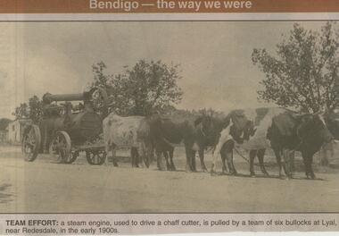 Bendigo Historical Society Inc.
Newspaper - JENNY FOLEY COLLECTION: TEAM EFFORT
Bendigo Advertiser ''The way we were'' from 2001. Team effort: a steam engine, used to drive a chaff cutter, is pulled by a team of six bullocks at Lyal, near Redesdale, in the early 1900s. The clip is in a folder.newspaper, bendigo advertiser, the way we were -
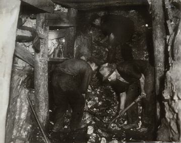 Bendigo Historical Society Inc.
Photograph - UNDERGROUND MINE
Black and white photograph of underground mine working with two workers shovelling rock in foreground, another miner working in upper background. Mine drive (end) showing wooden support posts and associated timber work.mining, underground equipment, miners, bendigo, mines and mining, mines, miners -
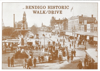 Bendigo Historical Society Inc.
Document - BASIL MILLER COLLECTION: BENDIGO HISTORIC WALK/DRIVE, 1988
Tourist brochure titled, 'Bendigo Historic Walk/Drive, Bendigo and District Tourism Association. Details central business district historic buildings, (Shamrock Hotel, Post Office, etc). List of attractions on rear page.Crown Castleton Publishers, 6 Schumakers Lane, Maiden Gully, Victoria, 3551.person, individual, basil miller -
Port Melbourne Historical & Preservation Society
Photograph - Electrical sub-station, Foreshore at Station Pier, Viva, 1989
Black and white photo taken 1989 by 'Viva', an artist from the Mission Arts Centre: electrical sub-station at foot of Station Pier, built 1940s?, which provided electricity to drive the travelling cranes on the pierbuilt environment - civic, piers and wharves - station pier, utilities - electricity -
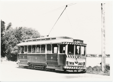 Ballarat Tramway Museum
Photograph - Black & White Photograph/s, Lloyd Rogers, early 1960's
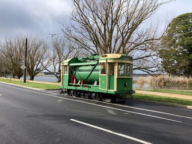
Yields information about the appearance of tram No. 12 in Wendouree Parade, St Aidans drive area, early 1960's.Black and white photograph of Ballarat tram No. 12 in Wendouree Parade, near St Aidans Drive, early 1960's. Tram has the destination of Victoria St. In the background is Lake Wendouree. Photo by Lloyd Rogers.trams, tramways, wendouree parade, st aidans drive, lake wendouree, tram 12 -
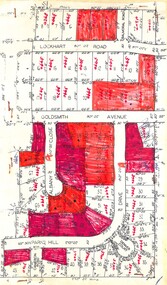 Ringwood and District Historical Society
Plan, Residential Land Sale Sub-division
Subdivision map of 60 residential allotments for sale in North Ringwood, Vic., circa 1968, with handwritten asking price annotations. Subdivision includes Lockhart Road, Goldsmith Avenue, Albany Close and Park Hill Drive. -
 University of Melbourne, Burnley Campus Archives
Album - Colour print, Views of Burnley Gardens, 1988-1990
16 colour photographs of: the drive from approximately the Plant Science Laboratory towards the Administration Building, many very similar, possibly to show the new curbing, 5 photographs of a plant Dietes?, 3 near the Dairy.plant science laboratory, administration building, driveway, quad, poplar -
 Greensborough Historical Society
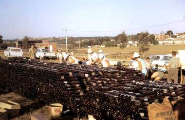
Photograph - Digital Image, Watsonia Scouts Bottle Drive, 1970_
In the days before recycling on rubbish collection days, community groups could raise money through a 'bottle drive'. These photographs show on bottle drive in Watsonia to raise money for the Watsonia Scout Hall. The location is A. K. Lines Reserve - in the background is St Mary's Church, with few houses and no freeway.Digital copy of colour photographwatsonia scouts, bottle drives, a k lines reserve -
 Ballarat Tramway Museum
Photograph - Commissioning the new track in Wendouree Parade, Paul Mong, 25-8-2022
Following reconstruction of the track between Depot Junction and St Aidans drive, the track was tested and commissioned: 1 - Scrubber tram 8 at St Aidans Drive 2 - Trams 33 and 671 in the new loop at Gardens Loop Wendouree Parade. 3 - Trams 28 and 38 at Carlton StDemonstrates the commissioning of the replaced track in Wendouree Parade.Set of three digital images of the Commissioning of the new track in Wendouree Parade 25-8-2022btm, new track, track replacement, track work, wendouree parade, commssioning, tram 8, tram 33, tram 671, tram 28, tram 38 -
Canterbury History Group
Photograph - Hazeldene
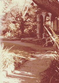
... Drives ...Sepia photograph of front and north side of "Hazeldene", 8 Balwyn Road Canterbury, showing detail of the cast iron lace on the verandah.canterbury, balwyn road, hazeldene, verandahs, cast iron work, drives, danks family, gardens -
 Eltham District Historical Society Inc
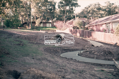
Slide, Fernside Avenue Playground, Briar Hill, 25 Jul 1973
Construction of the playground in progress, viewed from Toorac Drive looking up to Fernside Avenue35 mm colour positive transparency Mount - Agfacolor Service (Blue)briar hill, fernside avenue, playground, toorac drive -
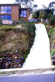 Greensborough Historical Society
Slide - Photograph, John Ramsdale, Apollo Parkways: Slide 131, 1990s
Photograph shows a house with steep drive and sold sign in the Apollo Parkways estate Greensborough.Part of the John Ramsdale collection of slides and audio visual material.Colour photograph scanned from slide.No maker's marks. No caption on slide.apollo parkways