Showing 531 items
matching east town hall
-
 Bendigo Historical Society Inc.
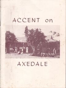
Book - Aileen and John Ellison collection: Accent on Axedale
Axedale is a town in Victoria, Australia. It is located on the McIvor Highway, in the City of Greater Bendigo, east of Bendigo. It was surveyed and proclaimed in 1861. (Wikipedia)A thirty-six pages book detailing the history of Axedale. Published by the centenary and back to Axedale committee. Chapters on early settlement, churches, education, police, municipal affairs, commerce, cemeteries, racecourse reserve, the railway, Eppalock weir, the hall, the wars, C.W.A. camp sites, C.F.A. sport. Many photographs throughout. L.J. Ellisonaxedale, history -
 Ballarat Tramway Museum
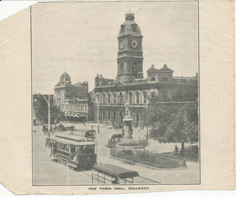
Magazine - Illustration from a magazine of ESCo tram in Sturt St, c1910
Reproduction of a photo of a East bound ESCo car- prior to 1913, (no windscreens) B&W, with Town Hall in background. Cut out of a magazine or journal- titled "The Town Hall, Ballarat." Tram appears to be fitted with destination boxes. From an original postcard at Reg Item 8412.Yields information about Sturt St and ESCo trams c1910Illustration printed on paper showing a view of Sturt St.trams, tramways, sturt st, esco, town hall, tram 5 -
 Ballarat Tramway Museum
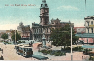
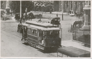
Postcard, "City Hall, Sturt Street, Ballarat"
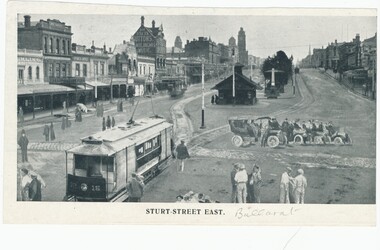
The image is of an ESCo tram just to the west of the Armstrong and Sturt St. intersection with the Ballarat Town Hall, the National Mutual building in the background. Tram traveling east. Tram has a destination box on the roof, but no driver's windows, say 1906 - 1912 or 1910c. Some horse-drawn vehicles in the image. Snows has a "Summer Clearance" sign on the building. From Reg Item 5129, appears to be tram No. 5. See also 8890, 8414 for other versions of this image.Yields infomation about Sturt St and ESCo tramsPostcard - coloured - Sturt St, card printed in Germany and number B374 19, with light brown ruled lines on rear.On rear is a letter to a lady in Adelaide with a 1d Victorian stamp, possibly during 1911ballarat, tramcars, esco, sturt st, town hall, tram 5 -
 Ballarat Tramway Museum
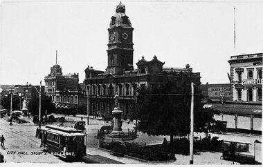
Postcard - Reproduction, City Hall Sturt St Ballarat - C1910
Image is of an ESCo tram just to the west of the Armstrong and Sturt St. intersection with the Ballarat Town Hall and the National Mutual building in the background. Tram travelling east. Tram has a destination box on the roof, but no drivers windows, say 1906 - 1912 or 1910c. Some horse drawn vehicles in the image. Snows has a "Summer Clearance" sign on the building. Yields information about Sturt St and ESCo trams c1910B&W print and scanned images of a postcard lent to the BTM by Mr. Norm DePomeroy, Dec. 1997.trams, tramways, sturt st, tram 5, esco, town hall -
 Ballarat Tramway Museum
Photograph - Digital image of ESCo tram 5 in Sturt St c1910
Digital image from the Wal Jack Ballarat Album of ESCo No. 5 in Sturt St, east bound at Armstrong St. with the Town Hall, National Mutual building and other shops in the background. Has a number of horse drawn vehicles, and people on both the rear and front end of the tram.Yields information about Sturt St and ESCo trams.Digital image of a photograph that was made from a postcard.On rear in ink "B'rat ? No. 5 in Sturt St" and in bottom right hand corner, CRC Field of Sydney photograph stamp, "2203 ?" and "per C. Fere"trams, tramways, sturt st, esco, tram 5, town hall -
 Ballarat Tramway Museum
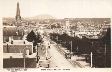
Postcard - Sturt Street Ballarat, Victoria, Rose Stereograph Co, 1920s?
Photo taken from the City Fire Brigade station at the corner of Sturt and Raglan Streets, looking east towards Mount Warrenheip. Has an eastbound ESCo tram. Photo shows the overhead structures, Harry Davies & Co. Drapers Importers, Ballarat Town Hall and the general view of the city. On the rear is a large Rose symbol and publisher details.Yields information about Sturt St during 1920sPostcard - Rose Series P 1717, Sturt Street looking east. Second copy - cigarette card size - 63mm x 87mmHas an address in Macarthur St, Ballarat on rear. Second copy has in ink "To Ken from Paul Kiwi4755"ballarat, sturt st, fire watch tower, harry davies -
 Ballarat Tramway Museum
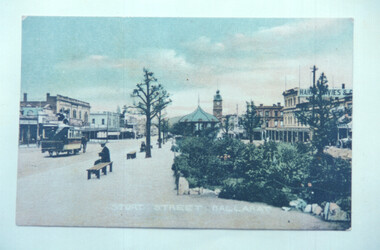
Postcard - Copy photograph - horse tram, Sturt Street Ballarat, c1900
Photograph of a postcard showing a horse tram travelling east in Sturt Street, taken from the median strip. Has the Harry Davies store and the Town Hall in the view.Demonstrates copy photographs of a coloured postcard and shows a horse tram in Sturt Street.Copy print or photograph of a coloured postcard showing a horse tram in Sturt Street Ballarat.ballarat, horse trams, tramways, sturt street, postcard -
 Ballarat Tramway Museum
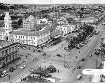
Photograph - Illustration/s, News and Information Bureau - Photo, Ballarat view from Town Hall, Oct. 1958
... Town Hall. Looking north east to Black Hill. See also... of Sturt St and Lydiard St from Town Hall. Looking north east ...Yields information about the Sturt and Lydiard St streetscape from the Town Hall, c1958.Photograph of intersection of Sturt St and Lydiard St from Town Hall. Looking north east to Black Hill. See also item with Reg. No. 667 of similar but earlier view. Photo is inside cover of ANZ quarterly survey, dated Oct. 1958. Shows four trams in City Loop and good photo of trackwork and motor cars of period. Not to be displayed - before copy neg made.Ballarat - important Provincial Citytrams, tramways, sturt st, black hill, aerial views, trackwork -
 Ballarat Tramway Museum
Drawing - Illustration/s, Sturt Street East - photoshopped
Yields information about the ESCo electric trams and the streetscape the Grenville St era and demonstrates how items were "photoshopped" or manipulated into the photo to make the street look busy.Photo montage of ESCo tram No 16, before windscreens (No 16) at Grenville St looking towards Town Hall. Four motor cars, and pedestrians have been added to the original photo to make the street "Look busy". On the reverse is a photo cropped at the top of Eureka Monument. The photo has buildings on the south side of Sturt St. in the view. Image re-scanned at high density 14-9-2013 and record checked. Two copies held.trams, tramways, sturt st, grenville st, ballarat trams, esco -
 Ballarat Tramway Museum
Newspaper, The Australasian, "Beautiful Ballarat, 1937", Nov. 1937
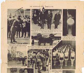
Yields information about Ballarat and its locations or environs late 1937.Pages iii,iv,v, and vi of the "The Australasian", 20/11/1937, featuring centre pages iv, and V, "Beautiful Ballarat" and 11 photos with captions of Ballarat, eg Town Hall (tram 33) in photo, Sturt St. from Town Hall, Arch of Victory, Ballarat East Signal box (internal view), on other pages, "To be a farmers boy" and general photos of current events on page III, photos black and white reproduction. Record reviewed and images of three pages added 7-9-2013.trams, tramways, ballarat town hall, sturt st, railway, lake wendouree -
 Buninyong & District Historical Society
Photograph - Original B/W Photograph, Former Whyke's Grocer building, Warrenheip St, Buninyong, 18 September 1993
Original building was established by Whyke's family Grocery, built in 1860s. Stripped to apricot brickwork. Verandah removed. Situated East Side of Warrenheip St between Eyre St and Forest St, Buninyong. Building much altered and used as a restaurant in 1970s. Fell into disrepair. Revival took place but not restoration. 1990s under threat of demolition if not conforming to council safety requirements. Building has since been renovated as a pizza restaurant (2023). Vacant lots have since been built on.Established by a prominent local family, an example of a mid 19th century shop. Black and white photo of former Whykes Grocer, 1860's. Streetscape photo of former Whykes Grocer brick building. Power pole with Warrenheip St sign. 3 other shopfronts visible, street trees and vacant land between shops.buninyong, whykes, grocery, building, street scape, warrenheip st -
 Buninyong & District Historical Society
Photograph - Original B/W Photograph, Clive Brooks, Buninyong roundabout, cnr Warrenheip and Learmonth Sts, with streetscape of shops on north-east corner, Sept 1993
Roundabout is situated at the centre of the town. Shops in streetscape are a mixture of 1800s and 1900s construction.The streetscape is of historic and social significance, representative of a small country town.Original B/W photograph of roundabout at the corner of Learmonth and Warrenheip Sts, Buninyong. Streetscape of shops on the NE corner. buninyong, roundabout, warrenheip st, learmonth st, streetscape, shops -
 Buninyong & District Historical Society
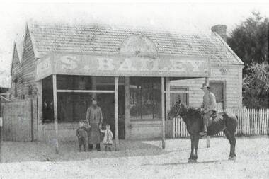
Photograph - B/W photograph, Samuel Bailey's Butcher Shop, Main Rd. Ballarat East, c 1879, 1994
Lost buildingB/W photo, Samuel Bailey's East End Butchery Shop, Main Rd. Ballarat East, c 1879"Samuel Bailey's Butcher shop, Main Rd. Ballarat East, circa 18798, opposite Sovereign Hill (Opposite Nettleton's, which was at the base of Sovereign Hill) shop, butcher, samuel bailey -
 Buninyong & District Historical Society
Photograph - Original B/W Photograph, Scott St looking east from intersection with Warrenheip St, 19th July 1993
Scott St was originally an alternative cart track down from Mt. Buninyong.This streetscape is of historic and social significance.Original B/W photo of Scott St looking east from its intersection with Warrenheip St.scott st, warrenheip st, streetscape, mount buninyong -
 Buninyong & District Historical Society
Photograph - B/W photograph, View of The Gong, old Brewery in the background, September 1993
The Gong has been part of the Buninyong industrial, cultural and recreational history pre and post 1837Fed by springs, the Gong has been a major source of water for industrial, pastoral, recreational uses and local wildlifeBlack and white photograph of the Gong, view of the South East Corner with the Old Brewery in the backgroundbotanic gardens, brewery, landscape, industry, water supply, springs -
 Buninyong & District Historical Society
Photograph - Original B/W Photograph, Clive Brooks, Warrenheip St Buninyong, east side, between Forest and Learmonth, 18/9/1993
Record of central Buninyong 1993B/W photo, Warrenheip St Buninyong, east side, between Forest and Learmonth, former Eagle Hotel at centre, Former National Bank far right, Town Hall Tower visible in background. buninyong, warrenheip st., eagle hotel, national bank -
 Buninyong & District Historical Society
Photograph - Original B/W Photograph, Clive Brooks, Old Brewery, Buninyong, 6 Sep 1993
Part of series to record changes in BuninyongB/W photo old Buninyong Brewery, south east of Gong, formerly Sheppard's Brewerybuninyong, brewery, sheppard -
 Buninyong & District Historical Society
Photograph - Original B/W Photograph, Clive Brooks, View from Catholic Church, Buninyong, south-east towards "Brim Brim.", 19 July 1993
Part of series to record changes in BuninyongB/W photo View from Catholic Church, Buninyong, south-east towards "Brim Brim'" across fieldsbuninyong, church, landscape, brim brim -
 Buninyong & District Historical Society
Photograph - Original Colour Photograph, Clive Brooks, View of The Gong, looking South East, 1982
Record of Gong 1980's.Colour photo, view looking S.E. of the Upper Dam, also known as The Gong,. Buildings, upper left hoiuse of T. Attwood, Market Gardener, 1860; Centre bluestone former brewery 1854 and behind extension 1980.gong, reservour, brewery, attwood -
 Buninyong & District Historical Society
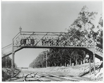
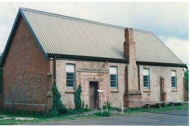
Photograph - Photo of Original Photograph, D. Macartney, B/W photo of footbridge over Buninyong Junction, in 1892 or 1897, 1995
Railway station and surrounds in 1940.Photo B/W of footbridge, lined with children, linking Dyte's Parade and Scott's Parade to Queen St. Ballarat. Bridge in distance shows the junction of the Buninyong Line near Ballarat East, known as Buninyong Junction. Taken 1892 or 1897.buninyong, railway, bunny, bridge, footbridge -
 Buninyong & District Historical Society
Photograph - Original Colour Photograph, Buninyong Uniting Church (formerly Presbyterian, 1860), east side, Ingles St, 1982
Record of Victorian era church in 1980's. NB Ingles St. is unpaved.Colour photo, Dr. Longden's house, Learmonth St. West.uniting church, presbyterian church, ingles street -
 Buninyong & District Historical Society
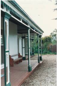
Photograph - Original Photograph, Clive Brooks, Netherby House, detail of east veranda, 9 Nov. 1991
detail of historic buildingColour photo Netherby House, detail of east veranda, wooden decorative posts and verand frieze, church pew is original seating from Holy Trinity Anglican Church.buninyong, netherby, holy trinity, pew -
 Buninyong & District Historical Society
Photograph - Original Photograph, Clive Brooks, Original Anglican Church/Common School (1857), east side, 9 Nov. 1991
detail of historic buildingColour photo Original Holy Trinity Anglican Church/Common School (April 1857), east side. Part of tennis court visible in foreground, with net and umpire's stand.buninyong, holy trinity, tennis court, anglican, church, common school -
 Buninyong & District Historical Society
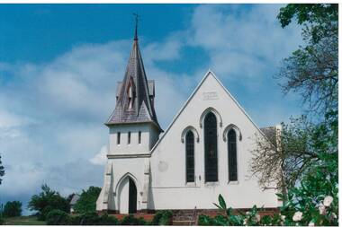
Photograph - Original Photograph, Clive Brooks, Buninyong Uniting Church (1860, formerly Presbyterian) Learmonth St. front view from east, 9 Nov. 1991
detail of historic buildingBuninyong Uniting Church (1860, formerly Presbyterian) Learmonth St. front view from east, showing steeple and gothic arched windows and entrance.buninyong, church, presbyterian, uniting, learmonth st. -
 Buninyong & District Historical Society
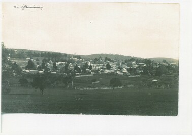
Photograph - Photo of Original Photograph, View of Buninyong looking down from south east around 1900, 1993
hidtoric recordCopy of B/W Photograph, View of Buninyong looking down from south east around 1900 across fields and wetland.buninyong, view -
 Buninyong & District Historical Society
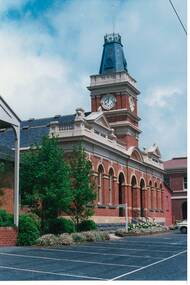
Photograph - Original Photograph, Buninyong Town Hall (1886) front, angle view from North-East, 9/11/1991
... Hall (1886) front, angle view from North-East, Buninyong Town ...historic buildingColour photograph, Buninyong Town Hall (1886) front, angle view from North-East, buninyong, view, town hall -
 Buninyong & District Historical Society
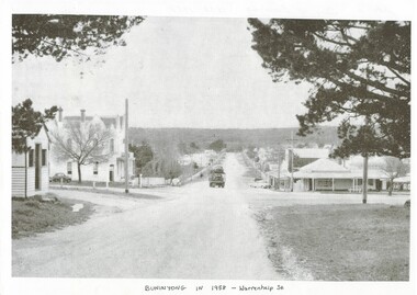
Photograph - Photo of Original Photograph, Warrenheip / Learmonth intersection, looking north up Warrenheip, in 1958, 1995
historic streetscapeB/W photograph, Warrenheip / Learmonth intersection, looking north up Warrenheip, in 1958, Crown Hotel, corner store visible, truck with double layer load of cars heading north."Specially Produced For A.H. Dixon Learmonth St, from east, Buninyong 1543"buninyong, learmonth st., warrenheip st., intersection, crown hotel, corner store -
 Buninyong & District Historical Society
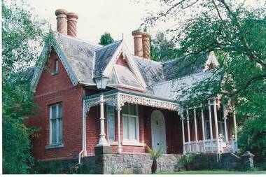
Photograph - Original Photograph, Clifton Villa (1859) Eyre St. Buninyong, front (east side), 9/11/1991
historic building, after restorationColour photograph, Clifton Villa (1859) Eyre St. Buninyong, front (east side), 3/4 view.buninyong, clifton villa, chimney -
 Buninyong & District Historical Society
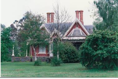
Photograph - Original Photograph, Clifton Villa (1859) Eyre St. Buninyong, front (east side), full on, 9/11/1991
historic building, after restorationColour photograph, Clifton Villa (1859) Eyre St. Buninyong, front (east side).buninyong, clifton villa, chimney -
 Kew Historical Society Inc
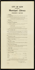
Document, City of Kew, City of Kew Municipal Library, Children's Section, 1953
1860: Kew's first library was the Kew Literary and Scientific Society, which opened on 6 August 1860. 1884: Kew Town Hall was extended and the library transferred to a room on the upper floor. This was not an ideal arrangement as the room was required for Council purposes. 1904: A cottage adjoining Kew Town Hall was purchased for use as a library. 1937: The library was closed for a major overhaul of stock and renovation of the building. It reopened in December 1937 and remained there for more than 35 years. 1973: When the Civic Centre opened in Charles Street, Kew, the library moved in. 1987: Kew Library moved to its current location in the converted city hall, overlooking the beautiful Alexandra Gardens. The library was officially opened at this site on Friday 23 October 1987 by the Mayor of Kew, Cr James Tutt. (Source: Boroondara Library Services)Historically and socially significant set of regulations governing the use of the children's library in Kew in the early 1950sOriginal framed rules and regulations of the junior section of the Kew Library, dated 16.6.1953, authorised by the Mayor (W.E.R. Hope) and Town Clerk (W.D.Birrell). The document also lists opening hours of the Kew and East Kew branches.kew public library - kew (vic), kew public library - east kew (vic), city of kew - library guidelines