Showing 909 items matching "eltham east"
-
 Eltham District Historical Society Inc
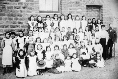
Negative - Photograph, Theodor Black, Eltham State School No. 209, 1905
John Brown (Head Teacher 1889-1906), assistant Ellen Sweeney and 53 schoolgirls, Eltham State School No. 209, 1905 Ina Falkiner is top row 4th from left Gertrude Falkiner is bottom row seated 4th from left. John Brown died 23 Sept 1906 after a short severe illness at age 55 and is buried in Box Hill Cemetery (Evelyn Observer 28 Sep 1906 p2). The book "We did open a school in Little Eltham" incorrectly states his date of death as 16/12/1906. Title The Evelyn Observer. (1906, September 28). Evelyn Observer and Bourke East Record (Vic. : 1902 - 1917), p. 2 (MORNING.) Url http://nla.gov.au/nla.news-article61129880 Description It is with sincere regret we record the death of Mr. John Brown, State school teacher, Eltham, which sad event took place at his residence, "Pine Brae," on Sunday night last, 23rd inst. after a severe illness of some few weeks' duration. The deceased gentleman was highly respected, and always took a lively and active interest in promoting the progress and prosperity of the district, and his loss will be much felt, He was only 55 years of age, and leaves a wife and large family to mourn their loss, and much sympathy is felt for them. The remains of the deceased were interred in the Box Hill cemetery on Wednesday afternoon last.Roll of 35mm colour negative film, 3 strips Associated print from negative (Copy of original print)Fuji 100eltham primary school, state school no. 209, eltham state school, eltham state school no. 209, ellen sweeney, gretrude falkiner, ina falkiner, john brown -
 Eltham District Historical Society Inc
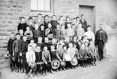
Negative - Photograph, Theodor Black, Eltham State School No. 209, 1905
John Brown (Head Teacher 1889-1906), assistant Ellen Sweeney and 42 schoolboys, Eltham State School No. 209, 1905 John Brown died 23 Sept 1906 after a short severe illness at age 55 and is buried in Box Hill Cemetery (Evelyn Observer 28 Sep 1906 p2). The book "We did open a school in Little Eltham" incorrectly states his date of death as 16/12/1906. Title The Evelyn Observer. (1906, September 28). Evelyn Observer and Bourke East Record (Vic. : 1902 - 1917), p. 2 (MORNING.) Url http://nla.gov.au/nla.news-article61129880 Description It is with sincere regret we record the death of Mr. John Brown, State school teacher, Eltham, which sad event took place at his residence, "Pine Brae," on Sunday night last, 23rd inst. after a severe illness of some few weeks' duration. The deceased gentleman was highly respected, and always took a lively and active interest in promoting the progress and prosperity of the district, and his loss will be much felt, He was only 55 years of age, and leaves a wife and large family to mourn their loss, and much sympathy is felt for them. The remains of the deceased were interred in the Box Hill cemetery on Wednesday afternoon last.Roll of 35mm colour negative film, 3 strips Associated print from negative (Copy of original print)Fuji 100eltham primary school, state school no. 209, eltham state school, eltham state school no. 209 -
 Eltham District Historical Society Inc
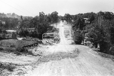
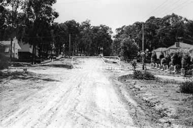
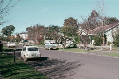
Photograph, Brougham Street, Eltham, c. Sep. 1966
Taken from alongside the Justice Precinct looking east. In the distance on the right hand verge there is a large Eucalyptus tree with a branch growing out over the road. That tree still stands today and is outside No. 102. The two houses on the right are possibly numbers 94 and 96.Black and white photographic printOriginally located in a Filmpro King Size Prints processing envelope $3.01 Shire of Eltham 9/9/66 and noted as Calrossie Ave area and crossed out Eltham-Yarra Glen Road, Bridge Street to Elsa Court existing conditions mid 1967brougham street, eltham, infrastructure, road construction, roads -
 Eltham District Historical Society Inc
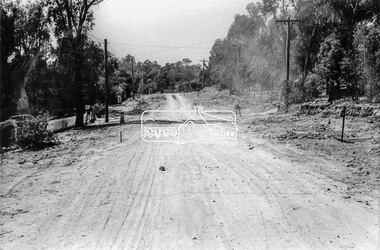
Photograph, Brougham Street, Eltham, c. Sep. 1966
... Eltham District Historical Society Inc 728 Main Rd Eltham ...Looking east No. 117. Large tree on left near electric pole still standing today in front of No. 121.Black and white photographic printOriginally located in a Filmpro King Size Prints processing envelope $3.01 Shire of Eltham 9/9/66 and noted as Calrossie Ave area and crossed out Eltham-Yarra Glen Road, Bridge Street to Elsa Court existing conditions mid 1967brougham street, eltham, infrastructure, road construction, roads -
 Eltham District Historical Society Inc
Photograph, Bridge Street, Eltham, c. Sep. 1966
... extended east eltham infrastructure road construction roads Bridge ...Last house on right is No. 122. The three houses on right remain relatively original in present time, the two visible houses on left have been substantially altered or replaced. Bridge Street ended at this point but has since been further extended eastBlack and white photographic printOriginally located in a Filmpro King Size Prints processing envelope $3.01 Shire of Eltham 9/9/66 and noted as Calrossie Ave area and crossed out Eltham-Yarra Glen Road, Bridge Street to Elsa Court existing conditions mid 1967eltham, infrastructure, road construction, roads, bridge street -
 Eltham District Historical Society Inc
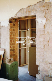
Photograph, Harry Gilham, Renovations to Eltham State School No. 209, Dalton Street, Eltham, 1994
Floor track in the 1921 infants room (now staff room). Wall recess appears in some 1900-1906 school group photographs which used the east end wall as their backdrop with Head Teacher John Brown present.Handwritten (HG's) information and details in blue ink on reverse sidedalton street, eltham primary school, renovations, building construction, buildings, eltham state school no. 209 -
 Eltham District Historical Society Inc
Photograph, Harry Gilham, Renovations to Eltham State School No. 209, Dalton Street, Eltham, 1994
This is the brick recess shown in the Head Teacher John Brown school photos 1900-1906. It was on the east end of the 1875 building.Handwritten (HG's) information and details in blue ink on reverse sidedalton street, eltham primary school, renovations, building construction, buildings, eltham state school no. 209 -
 Eltham District Historical Society Inc
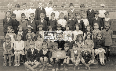
Photograph, Grade IIB, possibly Yarra Park State School No. 1406, East Melbourne, c.1930s
Unidentified school and students (not Eltham State School No. 209). Possibly Yarra Park State School No. 1406 (similar brickwork in backdrop to other photos (1928) in collection of a family that moved to Research. Yarra Park State School No.1406 (also known as Yarra Mews) was located at 1055 Punt Road, East Melbourne. It was built 1874 - 1877. Its current use is residential appartments. It is listed in the Victorian Heritage Database. Reproduction colour print of black and white printyarra park state school no. 1406, schools, yarra park, yarra mews, class photo, east melbourne, state school no. 1406 -
 Eltham District Historical Society Inc
Slide, Shire of Eltham War Memorial Tower, Eltham-Yarra Glen Road, Kangaroo Ground, 24 Jul 1973
... Eltham District Historical Society Inc 728 Main Rd Eltham ...Looking east towards the tower across the western title of land purchased by Council 16 Feb. 1973 upon which the Moor-rul viewing platform and grasslands now stand.35 mm colour positive transparency Mount - Agfacolor Service (Blue)kangaroo ground, shire of eltham, war memorial tower, eltham-yarra glen road, shire of eltham war memorial -
 Eltham District Historical Society Inc
Slide, Pryor Street, Eltham, 25 Jul 1973
... melbourne Looking east across Pryor Street towards the Eltham Police ...Looking east across Pryor Street towards the Eltham Police Station. The Police purchased the residence at 23 Pryor Street in 1959 to move from the old town centre of the late 1800s to be closer to the new town centre that shifted as a result of the railway opening in 1901. The residential house was renovated to Police requirements and operations commenced from this location in 1961. Diretly opposite and to the left of the Police Station is now a busy shopping centre car park.35 mm colour positive transparency Mount - Agfacolor Service (Blue)eltham, eltham police station, pryor street, streets, houses -
 Eltham District Historical Society Inc
Slide, Luck Street, Eltham, 25 Jul 1973
... Eltham District Historical Society Inc 728 Main Rd Eltham ...View looking east up Luck street from opposite the carpark entrance35 mm colour positive transparency Mount - Agfacolor Service (Blue)eltham, shopping centre, streets, luck street, houses -
 Eltham District Historical Society Inc
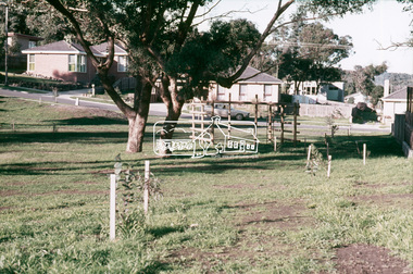
Slide, Briar Valley Reserve Playground, 11 Porter Street, Briar Hill, 25 Jul 1973
... Eltham District Historical Society Inc 728 Main Rd Eltham ...Looking east through the playground to Porter Street35 mm colour positive transparency Mount - Agfacolor Service (Blue)briar hill, playground, briar valley reserve playground, 11 porter street -
 Eltham District Historical Society Inc
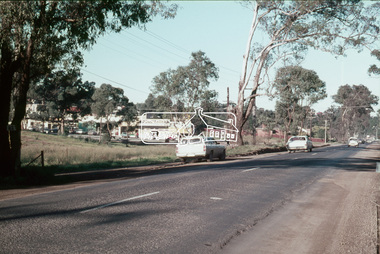
Slide, Main Road at Bolton Street, Eltham, 25 Jul 1973
... Eltham District Historical Society Inc 728 Main Rd Eltham ...Looking east along Main Road towards Bolton Street. Bolton street shops visible. Prior to duplication of Main Road35 mm colour positive transparency Mount - Agfacolor Service (Blue)bolton steet, bolton steet shops, eltham, main road -
 Eltham District Historical Society Inc
Slide, McCarthy Grove, Montmorency looking east towards Reichelt Avenue, near no. 27, c.Oct. 1980
One of a series of images of roads and infrastructure taken by Eltham Shire Council Planning and Engineering officers. They provide perspective of the changes in housing styles and road development that began sweeping in from the mid 1970s with increasing urbanisation of what was once more outlying suburbs and regions.35 mm colour positive transparency Mount - Kodak Kodachrome CardProcessed Oct 1980houses, infrastructure, mccarthy grove, montmorency, roads -
 Eltham District Historical Society Inc
Slide, Looking east along Buena Vista Drive, Montmorency near no. 69, c.Oct. 1980
One of a series of images of roads and infrastructure focussed on the Quinn Estate in Montmorency taken by Eltham Shire Council Planning and Engineering officers. They provide perspective of the changes in housing styles and road development that began sweeping in from the mid 1970s with increasing urbanisation of what was once more outlying suburbs and regions.35 mm colour positive transparency Mount - Kodak Kodachrome CardProcessed Oct 1980buena vista drive, horse, infrastructure, montmorency, roads -
 Eltham District Historical Society Inc
Slide, Quinn Estate looking east along Cressy Streett, Montmorency before Quinn Way, c.Oct. 1980
One of a series of images of roads and infrastructure focussed on the Quinn Estate in Montmorency taken by Eltham Shire Council Planning and Engineering officers. They provide perspective of the changes in housing styles and road development that began sweeping in from the mid 1970s with increasing urbanisation of what was once more outlying suburbs and regions.35 mm colour positive transparency Mount - Kodak Kodachrome CardProcessed Oct 1980infrastructure, montmorency, cressy street, housing estate, quinn estate, quinn way, roads -
 Eltham District Historical Society Inc
Slide, Quinn Estate looking east along Sackville Street just prior to Quinn Way, Montmorency, c.Oct. 1980
One of a series of images of roads and infrastructure focussed on the Quinn Estate in Montmorency taken by Eltham Shire Council Planning and Engineering officers. They provide perspective of the changes in housing styles and road development that began sweeping in from the mid 1970s with increasing urbanisation of what was once more outlying suburbs and regions.35 mm colour positive transparency Mount - Kodak Kodachrome CardProcessed Oct 1980roads, housing estate, infrastructure, montmorency, quinn estate, quinn way, sackville street -
 Eltham District Historical Society Inc
Slide - Photograph, Eltham Town Park, c.May 1988
In 1981 the Shire of Eltham Historical Society was asked by the Victorian Place Names Committee to comment on a proposal by the Shire of Eltham to assign names to parklands in Eltham as follows:- "Eltham Common" - the area between the municipal offices, Main Road, the Eltham railway -line, and Panther Place and containing Shillinglaw Cottage. The Shire has advised that this name has been used locally for the site since about 1975. "Alistair Knox Park" - the area bounded by the Eltham railway -line, Panther Place, Main Road, Bridge Street, and Susan Street, and through which flows the Diamond Creek. The area has been known locally as "Eltham Town Park" The proposed name "Alistair Knox Park" had created some local controversy with a number of reversals of the Council's decision and letters to the local paper both for and against the proposal. The society was reluctant to be drawn into this controversy particularly as there were known to be members with strong views both for and against the proposed name. The society appreciated the work done by Alistair Knox both in the formulation of the park concept and in its development but because of the controversy generated by the proposed naming and also because of the wide general use of the park by the public·, the name Eltham Town Park was felt more appropriate. The society noted that there was no outstanding historical associations with the land comprising the park which would warrant naming the park after any particular person, place or event. No objection was raised to the Eltham Common proposal as set-out above. The decision was made in the knowledge that Alistair Knox had been associated with the society over many years and was a prominent figure in the recent history of Eltham. He was regarded as a key figure in the environmental building movement and in particular was renowned for his use of mud bricks as a building material. He served as a councillor of the Shire of Eltham from 1971-1975, his final year as Shire President. It was during these years that the proposals to create the park in its present form were shaped and Alistair played a leading part in the decision to make it a landscaped passive recreational park rather than a sporting area. The parklands comprise a section of the Diamond Creek valley. The creek itself flows through the centre of the area which is overlooked by steep hills on each side. The parks form part of the land purchased from the Crown in 1851 by J.M. Holloway and then subdivided into allotments and called "Little Eltham". While most of the area was subdivided into residential lots the creek valley was subdivided into lots suitable for small farms. Some further subdivision took place over the years and the whole of the parks now comprises eight separate titles. A list of some of the former owners has been compiled but exhaustive research on all owners has not been carried out. The ownership of one parcel has been traced back to when it was purchased from Holloway by John Hicks Petty in 1874, long after it was subdivided. Other families owning land within the area over the years included Lyon, Rees, Clark, Waterfall, Carrucan, Graham, Hill and Morant. The character of the valley area has remained rural while development occurred on each side. Early photos show the area as orchard and grazing land. In 1901 the railway was constructed through the area resulting in the timber trestle bridge across the Diamond Creek. which is an important feature of the park landscape. A memorial obelisk to the Eltham servicemen killed in World War 1 was erected at the south eastern corner of the park. The site is now within the intersection of Main Road and Bridge Street and the memorial was shifted in the 1950s to the Eltham R.S.L. clubrooms. Following the financial failure of the local sub-branch, the memorial obelisk was again relocated to the Eltham War Memorial building precinct in 2011. During the early 1960's the Council started purchasing the land which now comprises the parks. In the late 1960's the area to the east of the Diamond Creek was used as a garbage tip and filled above the flood plain of the creek. When this area was filled the tip was transferred to the west side of the creek. From the early 1970's the area has been progressively developed as a park for passive recreation with ornamental lakes, extensive tree planting and landscaping. The character of the valley before the days of the tip has been recreated and this has earned a Landscape classification from the National Trust, an unusual honour for a man-made landscape. The parks are not only attractive in appearance. The large number of people using them, particularly at weekends and holidays is evidence of their popularity and the foresight and careful planning of local residents, Councillors and Council Staff. 35mm colour positive transparency (1 of 23) Mount - Kodak EktachromeProcess Date MAY 88Meltham, main road, alistair knox park, eltham town park -
 Eltham District Historical Society Inc
Slide - Photograph, Nyora Road, Eltham, c.1993
... Eltham District Historical Society Inc 728 Main Rd Eltham ...The east end of Nyora bewteen Stokes Place and Reynolds Road was unsealed. This section was only a fire access track as evidenced by the trees growing in the middle of the road. Real Estate agents would advertise homes as down a (dusty) country lane. The Nyora Road Resident Action Group arose to address concerns with Council regarding the dangerous conditions and traffic from outside the area using it as a 'rat-run' to avoid Main Road. Council traffic monitors showed that the amount of traffic was only 20% less than that of Mt Pleasant Road. The Action Group wanted the road closed at reynolds Road however Council elected to install speed calming devices along the sealed section between Stokes Place and Eucalyptus Road. Chicanes were added at several locations and a roundabout installed at Stokes Place in 2004. This remaining dirt section was sealed post 2004.35mm colour positive transparency Mount - Black and Whiteinfrastructure, roads, eltham, nyora road -
 Eltham District Historical Society Inc
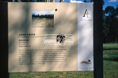
Slide - Photograph, Moonrise, Jane Price, Heidelberg School Artists Trail, Diamond Creek, c.Nov. 2001
The Heidelberg School Artists' Trail extends from Heidelberg through Eltham and Warrandyte and to the Dandenongs. It features signs depicting paintings of artists in the location in which they were painted. Transcription of sign: Jane Price is best known for her small moody impressionistic landscapes, many of which depict the rising moon and capture the softness of the evening twilight. In 1889, she shared a studio in Grosvenor Chambers, Collins Street east, Melbourne, with fellow Heidelberg School artists, Clara Southern and Jane Sutherland. She was also a close friend of Tom Roberts and Frederick McCubbin. Around the time of the First World War, and for several years after, she rented a ‘log cabin’ in Diamond Creek, and this was situated close to ‘The Shack’, the studio and home, of May Vale. Part of a slide show presentation "A Trip Down the Diamond Creek" by Russell Yeoman to the Eltham District Historical Society meeting of 14 Nov. 200135mm colour positive transparency Mount - Black and Whiteart in public places, diamond creek, heidelberg school artists trail, jane price, moonrise, public art, sign -
 Eltham District Historical Society Inc
Document, Prospectus: Kinloch Gardens, Eltham Victoria, 1998c
“Kinloch Gardens at Eltham, Victoria is planned as a comprehensively designed and cohesive residential environment.” “Only twelve innovatively designed houses ,will be situated within the established gardens and grounds of this historic Eltham estate. Building design and development will be under the control of the Kinloch Gardens design and construction team.” “Kinloch Gardens is situated on one of the highest points in Eltham and enjoys panoramic views in all directions.” “Kinloch Gardens lies hidden from the outside world behind high stone retaining walls, terraced embankments and extensive landscaping. The existing buildings, amongst the most significant of the Eltham / Montsalvat domestic building tradition are set in park like surrounds and enjoy panoramic views of the ranges to the north east and the city sky line to the west. New houses combined with sensitive landscaping will blend immediately into the established garden environment and will share the amenity and ambience of a very private and unique estate. The central theme of the landscape master plan is a garden reserve and a planted avenue terminating in a -small square.” “Houses vary in size from 120m2 (12.9 squares) to 210m2 (22.6 squares) (or larger) and include an extensive range of planning options. House types include: The Studio House The Tower House The Pergola House The Gallery House 'The Barn' is one of the existing buildings of Kinloch Gardens and is situated on the premium Lot 11.” Developer: Kinloch Pty Ltd. Project Managers: Creative Block Design Pty Ltd. Architects: Graeme Gunn and Ian Jelbart. Landscape Architect: Suzy Boyd. Builder: Vizarje Homes Pty Ltd. Surveyors and Engineers: Miller Merrigan.Digital file only; created from scan undertaken by EDHSarthur street, creative block design pty ltd., eltham, graeme gunn, houses, ian jelbart, kinloch gardens, kinloch pty ltd, miller merrigan, real estate, suzy boyd, vizarje homes pty ltd. -
 Eltham District Historical Society Inc
Document, Kinloch Gardens Property Album; Elders Real Estate sales material, 1998
“Kinloch Gardens at Eltham, Victoria is planned as a comprehensively designed and cohesive residential environment.” “Only twelve innovatively designed houses ,will be situated within the established gardens and grounds of this historic Eltham estate. Building design and development will be under the control of the Kinloch Gardens design and construction team.” “Kinloch Gardens is situated on one of the highest points in Eltham and enjoys panoramic views in all directions.” “Kinloch Gardens lies hidden from the outside world behind high stone retaining walls, terraced embankments and extensive landscaping. The existing buildings, amongst the most significant of the Eltham / Montsalvat domestic building tradition are set in park like surrounds and enjoy panoramic views of the ranges to the north east and the city sky line to the west. New houses combined with sensitive landscaping will blend immediately into the established garden environment and will share the amenity and ambience of a very private and unique estate. The central theme of the landscape master plan is a garden reserve and a planted avenue terminating in a -small square.” “Houses vary in size from 120m2 (12.9 squares) to 210m2 (22.6 squares) (or larger) and include an extensive range of planning options. House types include: The Studio House The Tower House The Pergola House The Gallery House 'The Barn' is one of the existing buildings of Kinloch Gardens and is situated on the premium Lot 11.” Developer: Kinloch Pty Ltd. Project Managers: Creative Block Design Pty Ltd. Architects: Graeme Gunn and Ian Jelbart. Landscape Architect: Suzy Boyd. Builder: Vizarje Homes Pty Ltd. Surveyors and Engineers: Miller Merrigan.Digital file only; created from scan undertaken by EDHSarthur street, elders real estate, eltham, kinloch gardens, real estate agent, the barn -
 Eltham District Historical Society Inc
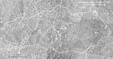
Work on paper (Sub-Item) - Photograph, St Helena East, St Helena West and Eltham West drains, ca 1980
black and white aerial photograph with boundary and drains marked over three page fold out eltham, st helena, drains, aerial view -
 Eltham District Historical Society Inc
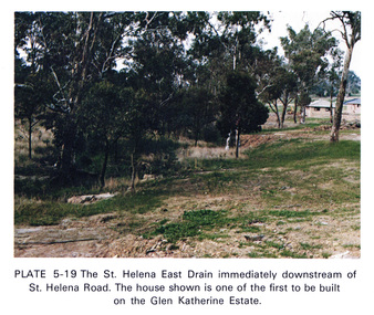
Work on paper (Sub-Item) - Photograph, St Helena East drain immediately downstream of St Helena Road
Colour photograph of St Helena East drain immediately downstream of St Helena Road, Greensborough. The house shown is one of the first to be built on the Glen Katherine Estate.eltham, drain, st helena, glen katherine estate, greensborough -
 Eltham District Historical Society Inc
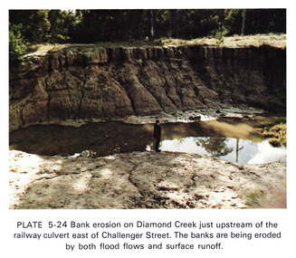
Work on paper (Sub-Item) - Photograph, Bank erosion on Diamond Creek just upstream of the railway culvert east of Challenger Street
Colour photograph of bank erosion on Diamond Creek just upstream of the railway culvert east of Challenger Street in Diamond Creek township. The banks are eroded by both flood flows and surface runoffeltham, drain, diamond creek, erosion, challenger street -
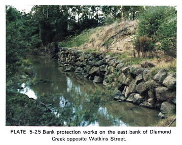 Eltham District Historical Society Inc
Work on paper (Sub-Item) - Photograph, Bank protection works on the east bank of Diamond Creek opposite Watkins Street
Colour photograph of bank protection works, using bluestone rocks to construct a wall on the east bank of Diamond Creek, to prevent erosion. Opposite Watkins Street, Diamond Creek townshipeltham, drain, diamond creek, erosion, watkins street, protection, bluestone, wall -
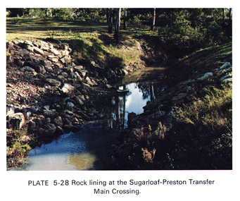 Eltham District Historical Society Inc
Work on paper (Sub-Item) - Photograph, Rock lining at the Sugarloaf-Preston transfer main crossing, 1976
Colour photograph of rock lining at the Sugarloaf-Preston transfer main crossing. The Sugarloaf Reservoir and the Winneke Water Treatment Plant (Winneke) are located 32 km north-east of Melbourne, near Christmas Hills. rock lining, water supply -
 Eltham District Historical Society Inc
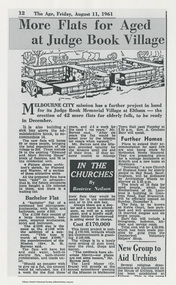
Work on paper - Newspaper article, More flats for aged at Judge Book Village, 11 August 1961
Article published in The Age, Friday, August 11, 1961, p12 as part of the "In the Churches" column by Beatrice Neilson describing the plans for expansion by Melbourne City Mission for the Judge Book Memorial Village at Eltham. Includes image of the architect's sketch. Article also refers to plans or new sites by the Mission at Kilsyth, Hawthorn, Sandringham and East Brunswick. In 2021 Judge Book is now known as St Vincent's Care Services, Eltham.judge book memorial village, aged care, melbourne city mission, beatrice neilson, the age, sister mildred greenwood, rev r h barnes, seniors, nursing home, aged care facility, judgebook -
 Eltham District Historical Society Inc
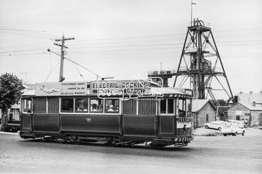
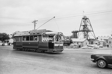
Photograph, Bendigo Tramways No. 7 en route to Golden Square passes the Central Deborah Gold Mining Co, High Street (Midland Highway) and Violet Street, Bendigo, January 1972, Jan 1972
... Eltham District Historical Society Inc 728 Main Rd Eltham ...Looking east from Midland Highway at intersection of Violet StreetDigital TIFF file Scan of 35mm Ilford FP3 black and white negative transparencybendigo, bendigo tramways no. 7, central deborah gold mining co. n.l., eaglehawk, george coop collection, golden square, high street, midland highway, tram, violet street -
 Eltham District Historical Society Inc
Photograph, Bendigo Tramways No. 7 en route to Golden Square passes the Central Deborah Gold Mining Co, High Street (Midland Highway) and Violet Street, Bendigo, January 1972, Jan 1972
... Eltham District Historical Society Inc 728 Main Rd Eltham ...Looking east from Midland Highway at intersection of Violet StreetDigital TIFF file Scan of 35mm Ilford FP3 black and white negative transparencybendigo, bendigo tramways no. 7, central deborah gold mining co. n.l., eaglehawk, george coop collection, golden square, high street, midland highway, tram, violet street