Showing 579 items matching "healesville"
-
 Eltham District Historical Society Inc
Photograph, Upper Yarra Dam, Spring Tour, 22 Oct 1995, 22/10/1995
EXPLORING THE UPPER YARRA (Newsletter No. 105, November 1995, by Bettina Woodburn) We enjoyed the Spring Excursion, this year "Exploring the Upper Yarra" - in spite of the constant rain and the countryside under the cloud cover, especially in the valleys, being mainly shiny shades of green. The occasional fields of buttercups, clumps of arum lilies and splendid rhododendron and other flowering bushes became very special. The Cobb and Co coach was warm and a cosy retreat as we zig-zagged on the highways and byways to glimpse the Yarra River, upstream and down, its secret places, and particularly the many bridges. Russell excelled as 'Poet Laureate', reading from Dacre Smyth's book. This 1979 publication includes paintings of all the bridges along the river with poems and brief descriptions of each one. Some of the bridges are in out of the way places and are not very well known. We looked forward to hearing the poetry as much as seeing the ' constructions'…Big Pat (was he short or tall, lean or fat? He did win the two hundred pound reward for discovering gold and had the creek named after him), about the 'Eddies'?, and the disliked 'meccano' bridge in Warburton, etc. etc. The hot roast lunch in the old Reefton Hotel was also most welcome. It was easy to imagine it peopled by miners and early settlers. Starting by crossing the new (1974) concrete bridge at Warrandyte we headed through Wonga Park with views to the Christmas Hills and to the escarpment of the Yering Gorge, which causes flood waters to back up through the Yarra Glen plain, so avoiding disasters downstream. At the end of a long driveway we found the wooden, privately owned Henley Bridge (1935 after the 1934 floods). This facilitates access to different parts of Henley Farm and to Lilydale. Everard Park, named after Blanche Shallard's father, a State Member for 17 years, below the Highway Yarra crossing was in need of care. It is 10 miles from Yarra Glen by road but, as "Yarra Marra” canoeists well know, 32 winding miles down by water. After more delightful countryside scenes we joined the Warburton Highway at Woori Yallock. From the old Railway Station at Launching Place the Centennial Trail for walkers, cyclists and ' horse riders has replaced the rails. The line from Lilydale was opened in 1901, and the last diesel freight train ran to Warburton in 1965. It continued to rain as we had morning tea in Warburton in a shelter between footbridges. From here we continued upstream past the Bridge to O'Shannasy Lodge and Reservoir, Starvation Creek, and the Peninsular tunnel (miners dug it as at Pound Bend) which we visited (scrambling down those steps!) on our return after lunch. Our furthermost point was the Upper Yarra Dam Reserve (and vast catchment area). Finished in 1957 after ten years work and 100 years after Yan Yean, it supplies much of Melbourne's water. After crossing the 30m Launching Place Bridge to the Eltham side of the Yarra and Healesville, we saw in the distance the Yarra Glen Timber Trestle Bridge over the river flats "the longest for years in the land it was said!" Harry's dream of "better weather over the Divide" unfortunately didn't come true, but I'm sure we 36 members will retain happy memories of a day that was wet and green and filled with Bridges. Bettina Woodburn - October 1995 Record of the Society's history of activities - Spring 1995 excursionRoll of 35mm colour negative film, 4 of 5 stripsKodak Gold 400-5shire of eltham historical society, activities, upper yarra dam, henley bridge -
 Eltham District Historical Society Inc
Photograph, Upper Yarra Dam, Spring Tour, 22 Oct 1995, 22/10/1995
EXPLORING THE UPPER YARRA (Newsletter No. 105, November 1995, by Bettina Woodburn) We enjoyed the Spring Excursion, this year "Exploring the Upper Yarra" - in spite of the constant rain and the countryside under the cloud cover, especially in the valleys, being mainly shiny shades of green. The occasional fields of buttercups, clumps of arum lilies and splendid rhododendron and other flowering bushes became very special. The Cobb and Co coach was warm and a cosy retreat as we zig-zagged on the highways and byways to glimpse the Yarra River, upstream and down, its secret places, and particularly the many bridges. Russell excelled as 'Poet Laureate', reading from Dacre Smyth's book. This 1979 publication includes paintings of all the bridges along the river with poems and brief descriptions of each one. Some of the bridges are in out of the way places and are not very well known. We looked forward to hearing the poetry as much as seeing the ' constructions'…Big Pat (was he short or tall, lean or fat? He did win the two hundred pound reward for discovering gold and had the creek named after him), about the 'Eddies'?, and the disliked 'meccano' bridge in Warburton, etc. etc. The hot roast lunch in the old Reefton Hotel was also most welcome. It was easy to imagine it peopled by miners and early settlers. Starting by crossing the new (1974) concrete bridge at Warrandyte we headed through Wonga Park with views to the Christmas Hills and to the escarpment of the Yering Gorge, which causes flood waters to back up through the Yarra Glen plain, so avoiding disasters downstream. At the end of a long driveway we found the wooden, privately owned Henley Bridge (1935 after the 1934 floods). This facilitates access to different parts of Henley Farm and to Lilydale. Everard Park, named after Blanche Shallard's father, a State Member for 17 years, below the Highway Yarra crossing was in need of care. It is 10 miles from Yarra Glen by road but, as "Yarra Marra” canoeists well know, 32 winding miles down by water. After more delightful countryside scenes we joined the Warburton Highway at Woori Yallock. From the old Railway Station at Launching Place the Centennial Trail for walkers, cyclists and ' horse riders has replaced the rails. The line from Lilydale was opened in 1901, and the last diesel freight train ran to Warburton in 1965. It continued to rain as we had morning tea in Warburton in a shelter between footbridges. From here we continued upstream past the Bridge to O'Shannasy Lodge and Reservoir, Starvation Creek, and the Peninsular tunnel (miners dug it as at Pound Bend) which we visited (scrambling down those steps!) on our return after lunch. Our furthermost point was the Upper Yarra Dam Reserve (and vast catchment area). Finished in 1957 after ten years work and 100 years after Yan Yean, it supplies much of Melbourne's water. After crossing the 30m Launching Place Bridge to the Eltham side of the Yarra and Healesville, we saw in the distance the Yarra Glen Timber Trestle Bridge over the river flats "the longest for years in the land it was said!" Harry's dream of "better weather over the Divide" unfortunately didn't come true, but I'm sure we 36 members will retain happy memories of a day that was wet and green and filled with Bridges. Bettina Woodburn - October 1995 Record of the Society's history of activities - Spring 1995 excursionRoll of 35mm colour negative film, 3 stripsKodak Gold 200-4shire of eltham historical society, activities, upper yarra dam, henley bridge -
 Eltham District Historical Society Inc
Photograph, Upper Yarra Dam, Spring Tour, 22 Oct 1995, 22/10/1995
EXPLORING THE UPPER YARRA (Newsletter No. 105, November 1995, by Bettina Woodburn) We enjoyed the Spring Excursion, this year "Exploring the Upper Yarra" - in spite of the constant rain and the countryside under the cloud cover, especially in the valleys, being mainly shiny shades of green. The occasional fields of buttercups, clumps of arum lilies and splendid rhododendron and other flowering bushes became very special. The Cobb and Co coach was warm and a cosy retreat as we zig-zagged on the highways and byways to glimpse the Yarra River, upstream and down, its secret places, and particularly the many bridges. Russell excelled as 'Poet Laureate', reading from Dacre Smyth's book. This 1979 publication includes paintings of all the bridges along the river with poems and brief descriptions of each one. Some of the bridges are in out of the way places and are not very well known. We looked forward to hearing the poetry as much as seeing the ' constructions'…Big Pat (was he short or tall, lean or fat? He did win the two hundred pound reward for discovering gold and had the creek named after him), about the 'Eddies'?, and the disliked 'meccano' bridge in Warburton, etc. etc. The hot roast lunch in the old Reefton Hotel was also most welcome. It was easy to imagine it peopled by miners and early settlers. Starting by crossing the new (1974) concrete bridge at Warrandyte we headed through Wonga Park with views to the Christmas Hills and to the escarpment of the Yering Gorge, which causes flood waters to back up through the Yarra Glen plain, so avoiding disasters downstream. At the end of a long driveway we found the wooden, privately owned Henley Bridge (1935 after the 1934 floods). This facilitates access to different parts of Henley Farm and to Lilydale. Everard Park, named after Blanche Shallard's father, a State Member for 17 years, below the Highway Yarra crossing was in need of care. It is 10 miles from Yarra Glen by road but, as "Yarra Marra” canoeists well know, 32 winding miles down by water. After more delightful countryside scenes we joined the Warburton Highway at Woori Yallock. From the old Railway Station at Launching Place the Centennial Trail for walkers, cyclists and ' horse riders has replaced the rails. The line from Lilydale was opened in 1901, and the last diesel freight train ran to Warburton in 1965. It continued to rain as we had morning tea in Warburton in a shelter between footbridges. From here we continued upstream past the Bridge to O'Shannasy Lodge and Reservoir, Starvation Creek, and the Peninsular tunnel (miners dug it as at Pound Bend) which we visited (scrambling down those steps!) on our return after lunch. Our furthermost point was the Upper Yarra Dam Reserve (and vast catchment area). Finished in 1957 after ten years work and 100 years after Yan Yean, it supplies much of Melbourne's water. After crossing the 30m Launching Place Bridge to the Eltham side of the Yarra and Healesville, we saw in the distance the Yarra Glen Timber Trestle Bridge over the river flats "the longest for years in the land it was said!" Harry's dream of "better weather over the Divide" unfortunately didn't come true, but I'm sure we 36 members will retain happy memories of a day that was wet and green and filled with Bridges. Bettina Woodburn - October 1995 Record of the Society's history of activities - Spring 1995 excursionRoll of 35mm colour negative film, 2 stripsKodak Gold 100-4shire of eltham historical society, activities, upper yarra dam, henley bridge -
 Eltham District Historical Society Inc
Photograph, Upper Yarra Dam, Spring Tour, 22 Oct 1995, 22/10/1995
EXPLORING THE UPPER YARRA (Newsletter No. 105, November 1995, by Bettina Woodburn) We enjoyed the Spring Excursion, this year "Exploring the Upper Yarra" - in spite of the constant rain and the countryside under the cloud cover, especially in the valleys, being mainly shiny shades of green. The occasional fields of buttercups, clumps of arum lilies and splendid rhododendron and other flowering bushes became very special. The Cobb and Co coach was warm and a cosy retreat as we zig-zagged on the highways and byways to glimpse the Yarra River, upstream and down, its secret places, and particularly the many bridges. Russell excelled as 'Poet Laureate', reading from Dacre Smyth's book. This 1979 publication includes paintings of all the bridges along the river with poems and brief descriptions of each one. Some of the bridges are in out of the way places and are not very well known. We looked forward to hearing the poetry as much as seeing the ' constructions'…Big Pat (was he short or tall, lean or fat? He did win the two hundred pound reward for discovering gold and had the creek named after him), about the 'Eddies'?, and the disliked 'meccano' bridge in Warburton, etc. etc. The hot roast lunch in the old Reefton Hotel was also most welcome. It was easy to imagine it peopled by miners and early settlers. Starting by crossing the new (1974) concrete bridge at Warrandyte we headed through Wonga Park with views to the Christmas Hills and to the escarpment of the Yering Gorge, which causes flood waters to back up through the Yarra Glen plain, so avoiding disasters downstream. At the end of a long driveway we found the wooden, privately owned Henley Bridge (1935 after the 1934 floods). This facilitates access to different parts of Henley Farm and to Lilydale. Everard Park, named after Blanche Shallard's father, a State Member for 17 years, below the Highway Yarra crossing was in need of care. It is 10 miles from Yarra Glen by road but, as "Yarra Marra” canoeists well know, 32 winding miles down by water. After more delightful countryside scenes we joined the Warburton Highway at Woori Yallock. From the old Railway Station at Launching Place the Centennial Trail for walkers, cyclists and ' horse riders has replaced the rails. The line from Lilydale was opened in 1901, and the last diesel freight train ran to Warburton in 1965. It continued to rain as we had morning tea in Warburton in a shelter between footbridges. From here we continued upstream past the Bridge to O'Shannasy Lodge and Reservoir, Starvation Creek, and the Peninsular tunnel (miners dug it as at Pound Bend) which we visited (scrambling down those steps!) on our return after lunch. Our furthermost point was the Upper Yarra Dam Reserve (and vast catchment area). Finished in 1957 after ten years work and 100 years after Yan Yean, it supplies much of Melbourne's water. After crossing the 30m Launching Place Bridge to the Eltham side of the Yarra and Healesville, we saw in the distance the Yarra Glen Timber Trestle Bridge over the river flats "the longest for years in the land it was said!" Harry's dream of "better weather over the Divide" unfortunately didn't come true, but I'm sure we 36 members will retain happy memories of a day that was wet and green and filled with Bridges. Bettina Woodburn - October 1995 Record of the Society's history of activities - Spring 1995 excursionRoll of 35mm colour negative film, 4 of 5 stripsKodak Gold 400-5shire of eltham historical society, activities, upper yarra dam, henley bridge -
 Eltham District Historical Society Inc
Photograph, Spring Excursion, Exploring the Upper Yarra, 22 October 1995, 22/10/1995
[article by Bettina Woodburn in EDHS Newsletter No. 105, November 1995:] EXPLORING THE UPPER YARRA - We enjoyed the Spring Excursion, this year "Exploring the Upper Yarra" - in spite of the constant rain and the countryside under the cloud cover, especially in the valleys, being mainly shiny shades of green. The occasional fields of buttercups, clumps of arum lilies and splendid rhododendron and other flowering bushes became very special. The Cobb and Co coach was warm and a cosy retreat as we zig-zagged on the highways and byways to glimpse the Yarra River, upstream and down, its secret places, and particularly the many bridges. Russell excelled as 'Poet Laureate', reading from Dacre Smyth's book. This 1979 publication includes paintings of all the bridges along the river with poems and brief descriptions of each one. Some of the bridges are in out-of-the-way places and are not very well known. We looked forward to hearing the poetry as much as seeing the 'constructions'… Big Pat (was he short or tall, lean or fat? - he did win the £200 reward for discovering gold and had the creek named after him), about the 'Eddies'?, and the disliked 'meccano' bridge in Warburton, etc. etc. The hot roast lunch in the old Reefton Hotel was also most welcome. It was easy to imagine it peopled by miners and early settlers. Starting by crossing the new (1974) concrete bridge at Warrandyte we headed through Wonga Park with views to the Christmas Hills and to the escarpment of the Yering Gorge, which causes flood waters to back up through the Yarra Glen plain, so avoiding disasters downstream. At the end of a long driveway we found the wooden, privately owned Henley Bridge (1935 after the 1934 floods). This facilitates access to different parts of Henley Farm and to Lilydale. Everard Park, named after Blanche Shallard's father, a State Member for 17 years, below the Highway Yarra crossing was in need of care. It is 10 miles from Yarra Glen by road but, as "Yarra Marra” canoeists well know, 32 winding miles down by water. After more delightful countryside scenes we joined the Warburton Highway at Woori Yallock. From the old Railway Station at Launching Place the Centennial Trail for walkers, cyclists and horse riders has replaced the rails. The line from Lilydale was opened in 1901, and the last diesel freight train ran to Warburton in 1965. It continued to rain as we had morning tea in Warburton in a shelter between footbridges. From here we continued upstream past the Bridge to O'Shannassy Lodge and Reservoir, Starvation Creek, and the Peninsular tunnel (miners dug it as at Pound Bend) which we visited (scrambling down those steps!) on our return after lunch. Our furthermost point was the Upper Yarra Dam Reserve (and vast catchment area). Finished in 1957 after ten years' work and 100 years after Yan Yean, it supplies much of Melbourne's water. After crossing the 30m Launching Place Bridge to the Eltham side of the Yarra and Healesville, we saw in the distance the Yarra Glen Timber Trestle Bridge over the river flats "the longest for years in the land it was said!" Harry's dream of "better weather over the Divide" unfortunately didn't come true, but I'm sure we 36 members will retain happy memories of a day that was wet and green and filled with Bridges.Two colour photographsactivities, upper yarra, upper yarra dam -
 Eltham District Historical Society Inc
Photograph, Yarra River from Henley Bridge, Kangaroo Ground, Spring Excursion, Exploring the Upper Yarra, 22 October 1995, 22/10/1995
[article by Bettina Woodburn in EDHS Newsletter No. 105, November 1995:] EXPLORING THE UPPER YARRA - We enjoyed the Spring Excursion, this year "Exploring the Upper Yarra" - in spite of the constant rain and the countryside under the cloud cover, especially in the valleys, being mainly shiny shades of green. The occasional fields of buttercups, clumps of arum lilies and splendid rhododendron and other flowering bushes became very special. The Cobb and Co coach was warm and a cosy retreat as we zig-zagged on the highways and byways to glimpse the Yarra River, upstream and down, its secret places, and particularly the many bridges. Russell excelled as 'Poet Laureate', reading from Dacre Smyth's book. This 1979 publication includes paintings of all the bridges along the river with poems and brief descriptions of each one. Some of the bridges are in out-of-the-way places and are not very well known. We looked forward to hearing the poetry as much as seeing the 'constructions'… Big Pat (was he short or tall, lean or fat? - he did win the £200 reward for discovering gold and had the creek named after him), about the 'Eddies'?, and the disliked 'meccano' bridge in Warburton, etc. etc. The hot roast lunch in the old Reefton Hotel was also most welcome. It was easy to imagine it peopled by miners and early settlers. Starting by crossing the new (1974) concrete bridge at Warrandyte we headed through Wonga Park with views to the Christmas Hills and to the escarpment of the Yering Gorge, which causes flood waters to back up through the Yarra Glen plain, so avoiding disasters downstream. At the end of a long driveway we found the wooden, privately owned Henley Bridge (1935 after the 1934 floods). This facilitates access to different parts of Henley Farm and to Lilydale. Everard Park, named after Blanche Shallard's father, a State Member for 17 years, below the Highway Yarra crossing was in need of care. It is 10 miles from Yarra Glen by road but, as "Yarra Marra” canoeists well know, 32 winding miles down by water. After more delightful countryside scenes we joined the Warburton Highway at Woori Yallock. From the old Railway Station at Launching Place the Centennial Trail for walkers, cyclists and horse riders has replaced the rails. The line from Lilydale was opened in 1901, and the last diesel freight train ran to Warburton in 1965. It continued to rain as we had morning tea in Warburton in a shelter between footbridges. From here we continued upstream past the Bridge to O'Shannassy Lodge and Reservoir, Starvation Creek, and the Peninsular tunnel (miners dug it as at Pound Bend) which we visited (scrambling down those steps!) on our return after lunch. Our furthermost point was the Upper Yarra Dam Reserve (and vast catchment area). Finished in 1957 after ten years' work and 100 years after Yan Yean, it supplies much of Melbourne's water. After crossing the 30m Launching Place Bridge to the Eltham side of the Yarra and Healesville, we saw in the distance the Yarra Glen Timber Trestle Bridge over the river flats "the longest for years in the land it was said!" Harry's dream of "better weather over the Divide" unfortunately didn't come true, but I'm sure we 36 members will retain happy memories of a day that was wet and green and filled with Bridges.Colour photographactivities, upper yarra, henley bridge -
 Eltham District Historical Society Inc
Photograph, Peter Bassett-Smith, Upper Yarra Dam, Spring Tour, 22 Oct 1995, 22/10/1995
EXPLORING THE UPPER YARRA (Newsletter No. 105, November 1995, by Bettina Woodburn) We enjoyed the Spring Excursion, this year "Exploring the Upper Yarra" - in spite of the constant rain and the countryside under the cloud cover, especially in the valleys, being mainly shiny shades of green. The occasional fields of buttercups, clumps of arum lilies and splendid rhododendron and other flowering bushes became very special. The Cobb and Co coach was warm and a cosy retreat as we zig-zagged on the highways and byways to glimpse the Yarra River, upstream and down, its secret places, and particularly the many bridges. Russell excelled as 'Poet Laureate', reading from Dacre Smyth's book. This 1979 publication includes paintings of all the bridges along the river with poems and brief descriptions of each one. Some of the bridges are in out of the way places and are not very well known. We looked forward to hearing the poetry as much as seeing the ' constructions'…Big Pat (was he short or tall, lean or fat? He did win the two hundred pound reward for discovering gold and had the creek named after him), about the 'Eddies'?, and the disliked 'meccano' bridge in Warburton, etc. etc. The hot roast lunch in the old Reefton Hotel was also most welcome. It was easy to imagine it peopled by miners and early settlers. Starting by crossing the new (1974) concrete bridge at Warrandyte we headed through Wonga Park with views to the Christmas Hills and to the escarpment of the Yering Gorge, which causes flood waters to back up through the Yarra Glen plain, so avoiding disasters downstream. At the end of a long driveway we found the wooden, privately owned Henley Bridge (1935 after the 1934 floods). This facilitates access to different parts of Henley Farm and to Lilydale. Everard Park, named after Blanche Shallard's father, a State Member for 17 years, below the Highway Yarra crossing was in need of care. It is 10 miles from Yarra Glen by road but, as "Yarra Marra” canoeists well know, 32 winding miles down by water. After more delightful countryside scenes we joined the Warburton Highway at Woori Yallock. From the old Railway Station at Launching Place the Centennial Trail for walkers, cyclists and ' horse riders has replaced the rails. The line from Lilydale was opened in 1901, and the last diesel freight train ran to Warburton in 1965. It continued to rain as we had morning tea in Warburton in a shelter between footbridges. From here we continued upstream past the Bridge to O'Shannasy Lodge and Reservoir, Starvation Creek, and the Peninsular tunnel (miners dug it as at Pound Bend) which we visited (scrambling down those steps!) on our return after lunch. Our furthermost point was the Upper Yarra Dam Reserve (and vast catchment area). Finished in 1957 after ten years work and 100 years after Yan Yean, it supplies much of Melbourne's water. After crossing the 30m Launching Place Bridge to the Eltham side of the Yarra and Healesville, we saw in the distance the Yarra Glen Timber Trestle Bridge over the river flats "the longest for years in the land it was said!" Harry's dream of "better weather over the Divide" unfortunately didn't come true, but I'm sure we 36 members will retain happy memories of a day that was wet and green and filled with Bridges. Bettina Woodburn - October 1995 Record of the Society's history of activities - Spring 1995 excursionColour photographactivities, upper yarra dam, 1995, peter bassett-smith -
 Eltham District Historical Society Inc
Photograph, Peter Bassett-Smith, Upper Yarra Dam, Spring Tour, 22 Oct 1995, 22/10/1995
EXPLORING THE UPPER YARRA (Newsletter No. 105, November 1995, by Bettina Woodburn) We enjoyed the Spring Excursion, this year "Exploring the Upper Yarra" - in spite of the constant rain and the countryside under the cloud cover, especially in the valleys, being mainly shiny shades of green. The occasional fields of buttercups, clumps of arum lilies and splendid rhododendron and other flowering bushes became very special. The Cobb and Co coach was warm and a cosy retreat as we zig-zagged on the highways and byways to glimpse the Yarra River, upstream and down, its secret places, and particularly the many bridges. Russell excelled as 'Poet Laureate', reading from Dacre Smyth's book. This 1979 publication includes paintings of all the bridges along the river with poems and brief descriptions of each one. Some of the bridges are in out of the way places and are not very well known. We looked forward to hearing the poetry as much as seeing the ' constructions'…Big Pat (was he short or tall, lean or fat? He did win the two hundred pound reward for discovering gold and had the creek named after him), about the 'Eddies'?, and the disliked 'meccano' bridge in Warburton, etc. etc. The hot roast lunch in the old Reefton Hotel was also most welcome. It was easy to imagine it peopled by miners and early settlers. Starting by crossing the new (1974) concrete bridge at Warrandyte we headed through Wonga Park with views to the Christmas Hills and to the escarpment of the Yering Gorge, which causes flood waters to back up through the Yarra Glen plain, so avoiding disasters downstream. At the end of a long driveway we found the wooden, privately owned Henley Bridge (1935 after the 1934 floods). This facilitates access to different parts of Henley Farm and to Lilydale. Everard Park, named after Blanche Shallard's father, a State Member for 17 years, below the Highway Yarra crossing was in need of care. It is 10 miles from Yarra Glen by road but, as "Yarra Marra” canoeists well know, 32 winding miles down by water. After more delightful countryside scenes we joined the Warburton Highway at Woori Yallock. From the old Railway Station at Launching Place the Centennial Trail for walkers, cyclists and ' horse riders has replaced the rails. The line from Lilydale was opened in 1901, and the last diesel freight train ran to Warburton in 1965. It continued to rain as we had morning tea in Warburton in a shelter between footbridges. From here we continued upstream past the Bridge to O'Shannasy Lodge and Reservoir, Starvation Creek, and the Peninsular tunnel (miners dug it as at Pound Bend) which we visited (scrambling down those steps!) on our return after lunch. Our furthermost point was the Upper Yarra Dam Reserve (and vast catchment area). Finished in 1957 after ten years work and 100 years after Yan Yean, it supplies much of Melbourne's water. After crossing the 30m Launching Place Bridge to the Eltham side of the Yarra and Healesville, we saw in the distance the Yarra Glen Timber Trestle Bridge over the river flats "the longest for years in the land it was said!" Harry's dream of "better weather over the Divide" unfortunately didn't come true, but I'm sure we 36 members will retain happy memories of a day that was wet and green and filled with Bridges. Bettina Woodburn - October 1995 Record of the Society's history of activities - Spring 1995 excursionColour photographactivities, upper yarra dam, 1995 -
 Eltham District Historical Society Inc
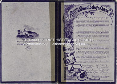
Document - Booklet, Valedictory Address to Reverend Edward Selwyn Chase, 21 Nov. 1925
Rev. Edward Selwyn Chase (1864-1950), son of Canon Chase was Curate at St John's Anglican Church, Healesville 1895-1902. He then transferred to Yarraville Anglican Church 1902-1904.. In 1907 he became Vicar for the parish comprising the Anglican churches St Matthew, Panton Hill, Queenstown, Hurstbridge and Kinglake where he serrved for 18 years. This is a copy of the valedictory address given on the eve of his departure from the parish, 21 November 1925 and was signed on behalf of the parishioners by the secretaries and treasurers of each district. A copy of the address was reproduced in the Advertiser, Friday, December 4, 1925, p4 THE ADDRESS. (1925, December 4). Advertiser (Hurstbridge, Vic. : 1922 - 1939), p. 4 (AFTERNOON). Retrieved November 23, 2024, from http://nla.gov.au/nla.news-article56659141Advertiser (Hurstbridge, Vic. : 1922 - 1939), Friday 4 December 1925, page 4 ________________________________________ THE ADDRESS. The following is a copy of the address : REV. EDWARD SELWYN CHASE. On the eve of your departure after 18 years of faithful service as Vicar of this parish, comprising the Anglican churches St. Matthew, Panton Hill, Queenstown Hurstbridge, and Kinglake, we, your parishioners and friends, united in one body, desire to express our heartfelt appreciation of your good works, both spiritual and social, during your long sojourn in this parish. Your generous aid and spiritual ad-i ministration have always been at the service of those in want or lying on beds of sickness. By relieving their necessities and soothing their afflictions you have earned our heartfelt gratitude. "That best portion of a good man's life, that little, nameless unremembered act of kindness and of love." --Wordsworth. You have always taken a practical interest in foreign and home missions, and your labor of love amongst our black brethren in Northern Australia, until your health was undermined, is typical of your sincerity in things that are "more excellent." "When we consider the deep interest you have taken in the welfare bf. our children, striving by precept and example to mould the characters of our future citizens, particularly may we mention the boy scouts, and religious instruction in our schools, we feel that we are greatly indebted to you. May we also be permitted to link with your name that of your worthy wife, Mrs Chase, whose earnest work as superintendent of the Sunday school and Ladies' Guild has learned our warmest approval. "As ye sow so shall ye reap." During your many years of Divine ministration you have shown your great love of God, King, and Empire, and as a citizen you have been exemplary in the discharge of your civil duties, and have always taken a keen interest in the progress of our district. We feel, therefore, that it is good for you to. know that your work among us has found appreciation throughout the parish, and even beyond, and we all join in wishing both you and Mrs Chase God speed and success in the work God has allotted you. May you enjoy good health and long be spared to labor in the Master's vineyard, for we have found you a workman approved by the Great Architect, that needeth not to be ashamed, rightly dividing the Word of truth. "I know thy works and charity and service and faith, and thy patience and thy works, and the last be more than the first." On behalf of the combined churches of -the parish, and friends of the district, .we hereto affix our signatures. The address was signed on behalf of the parishioners by the secretaries and treasurers of each district.hurstbridge, kinglake, panton hil, queenstown, reverend edward selwyn chase, st andrews, st matthew's church -
 Eltham District Historical Society Inc
Journal, Peter Doughtery, ArtStreams: News in arts and cultural heritage; Vol. 1, No. 2, Dec 1996/Jan 1997, 1996
Vol. 1, No. 2 Dec 1996/Jan 1997 CONTENTS ADVENTURE WITH COLOUR Teenage cancer patients challenge their illness with art 3 CD REVIEWS New music by local musicians 5 LIVE AND LET LIVE 20 years of environmental living 6 AUSTRALIA REVISITED Artist Charles Reddington ponders live 30 years on 8 POETRY REVIEW Anne Delaney looks at new work by Jennifer Harrison and Jordie Albiston 11 PHOTOGRAPHY Katherine Jones aims at hard edges 16 IMAGES FROM A DARK PAST Holocaust survivor paints out a traumatic part of his life 18 MORALITY OF JUSTICE The Truth Game - a play by Ray Mooney 21 ART FROM THE HEART An exhibition that crosses boundaries 22 SHORT STORY New story from an emerging writer 25 ART IN THE CEMETERY Darebin launches a new project to decorate its new mausoleum 28 LISTINGS Artists, performers and galleries 29 KEYWORDS 895 Main Road, 1994 Moet et Chandon Fellowship, Adventure with Colour, Alan Bonney, Alan Constable, Alun Leach-Jones, Amada Laming, Anne Connor & Associates, Anne Delaney, Anthony Day, Art Streams Magazine, Artist-in-residence, Arts by the Waters, Arts project Australia, Auschwitz, Banyule Jazz Festival, Barbara Veheary, Bend of Islands Conservation Association (BICA), Bend of Islands Estate, Bend of Islands, Bill Downing, Bulleen Art & Garden Centre, Bulleen Nursery, Caffe Poco, Carlton Courthouse Theatre, Catani Boulevard, Catherine Oxley Reserve, Charles Reddington, Charlie Dowley, Cheryl Daye, Chris McAuliffe, Clifton Pugh, Colin Lanceley, Cornelia Selover, Creativitie et Handicap Mental (CREAHM), Cynthia Hardman, Cyril Tawney, Damian Eyre, Daniel Lillford, Danuta Michalska, Darebin Arts and Entertainment Centre, Darebin City Council, Department of Fine Arts, Donald Campbell, Dora Zable, Dorothy Berry, dunmoochin, E.H. Cameron, Edward (Ned) Haughton, Edward Car, Elizabeth Vercoe, Eltham High School, Eltham Living and Learning Centre, Environmental Living Zone (ELZ), Eric Bogle, Eucalypso, Felix Tuszynski, Food For All Seasons, Frank Hodgkinson, Fulli Andrinopoulos, Gallery of Georges of Collins Street, Gallery of Slavic Art, Glen Agnes Bend of Islands Estate, Glen Agnes Estate, Gongflers drive, Greg O'Leary, Harold (Jimmy) Fuller, Helen O'Grady Children's Drama Academy, Henley Road, Ian Doolan Hamilton, Ian Gawler, Inside Out/Outside In, Ironbark Road, Janice McBride, Jennifer Harrison, Jennifer McGregor, Jessie Agnes Haughton, Jimmy Pike, Joan Blakey, John Mackay Northe, John Rasmussen, Jordie Albiston, Julian Martin, Kangaroo Ground, Katherine Jones, Kelvin Heffernan, Kew Coattage, Kitty Ginter, Lavita Mossop, Les darcy, Les Gyori, Life with Jane, Lorraine Larter, Luc Boulange, Luciana Giardina, Manningham Artspace, Manningham City Council, Mariann Moxon, Mark Capozzi, Mark Chapman, Mark Wilkinson, Maxine Ryder, Melbourne Police Pipe Band, Mick Woiwod, Mike O'Rourke, Monica Burns, Montsalvat, Myra Hilgendorf, Nancye Ball, Page family, Pam Crohan, Pam Dougherty, Poetry, Preston Public Cemetery, Ray Mooney, Richard Haese, Robert Hughes, Robyn Kirkpatrick, Roger Lemke, Ron Hanson, Sandra Harvey, Shire of Eltham Office site, Shire of Healesville, Shire of Nillumbik, Shire Offices, Sounds by the Waters, Stelio Costa, Steven Tynan, Steven Worrell, Stewart Whiffin, Sue Howard, Sue Whiffin, Sugarloaf Reservoir, Sydney Ball, The Art of Australia, The Mews, The Truth Game, Tom Fantl, Tony Inglese, Tuszynski Survey Exhibition, University of Melbourne, Valerio Ciccone, victorian artists supplies, Watson Creek Bridge, Watsons Creek, Wayne Marnell, Woody Guthrie, Yarra Brae Dam, Yarra River"Peter Dougherty has been involved in the local art scene for many years. As publisher and editor of the arts magazine Artstreams, his comments on the various branches of the arts are widely respected. His "The Arts" column in the Diamond Valley Leader presents a brief summary for a much wider cross section of the local community. Peter also operates his own gallery and the Artstreams Cafe at the St Andrews market. Peter has a wealth of knowledge about present day and historical aspects of local art and artists." - Eltham District Historical Society Newsletter No. 161, March 2005Colour front and back cover with feature articles and literary pieces with photographs and advertisements printed in black and white. 36 pages, 30 cm. Vol. 1, no. 1 (Nov. 1996) - Vol. 10, no. 5 (summer ed. 2005/06) art streams, feliz tuszynski, elizabeth vercoe, eucalypso, bend of islands, charles reddington, jennifer harrison, jordie albiston, katherine jones, anne bonney, mick woiwood, anne connor, anne delaney, ray mooney, pam dougherty, arts project australia, lavita mossop, preston public cemetery, helen o'grady children's drama academy, bulleen nursery -
 Eltham District Historical Society Inc
Photograph, Henley Bridge, Spring Excursion, Exploring the Upper Yarra, 22 October 1995, 22/10/1995
[article by Bettina Woodburn in EDHS Newsletter No. 105, November 1995:] EXPLORING THE UPPER YARRA - We enjoyed the Spring Excursion, this year "Exploring the Upper Yarra" - in spite of the constant rain and the countryside under the cloud cover, especially in the valleys, being mainly shiny shades of green. The occasional fields of buttercups, clumps of arum lilies and splendid rhododendron and other flowering bushes became very special. The Cobb and Co coach was warm and a cosy retreat as we zig-zagged on the highways and byways to glimpse the Yarra River, upstream and down, its secret places, and particularly the many bridges. Russell excelled as 'Poet Laureate', reading from Dacre Smyth's book. This 1979 publication includes paintings of all the bridges along the river with poems and brief descriptions of each one. Some of the bridges are in out-of-the-way places and are not very well known. We looked forward to hearing the poetry as much as seeing the 'constructions'… Big Pat (was he short or tall, lean or fat? - he did win the £200 reward for discovering gold and had the creek named after him), about the 'Eddies'?, and the disliked 'meccano' bridge in Warburton, etc. etc. The hot roast lunch in the old Reefton Hotel was also most welcome. It was easy to imagine it peopled by miners and early settlers. Starting by crossing the new (1974) concrete bridge at Warrandyte we headed through Wonga Park with views to the Christmas Hills and to the escarpment of the Yering Gorge, which causes flood waters to back up through the Yarra Glen plain, so avoiding disasters downstream. At the end of a long driveway we found the wooden, privately owned Henley Bridge (1935 after the 1934 floods). This facilitates access to different parts of Henley Farm and to Lilydale. Everard Park, named after Blanche Shallard's father, a State Member for 17 years, below the Highway Yarra crossing was in need of care. It is 10 miles from Yarra Glen by road but, as "Yarra Marra” canoeists well know, 32 winding miles down by water. After more delightful countryside scenes we joined the Warburton Highway at Woori Yallock. From the old Railway Station at Launching Place the Centennial Trail for walkers, cyclists and horse riders has replaced the rails. The line from Lilydale was opened in 1901, and the last diesel freight train ran to Warburton in 1965. It continued to rain as we had morning tea in Warburton in a shelter between footbridges. From here we continued upstream past the Bridge to O'Shannassy Lodge and Reservoir, Starvation Creek, and the Peninsular tunnel (miners dug it as at Pound Bend) which we visited (scrambling down those steps!) on our return after lunch. Our furthermost point was the Upper Yarra Dam Reserve (and vast catchment area). Finished in 1957 after ten years' work and 100 years after Yan Yean, it supplies much of Melbourne's water. After crossing the 30m Launching Place Bridge to the Eltham side of the Yarra and Healesville, we saw in the distance the Yarra Glen Timber Trestle Bridge over the river flats "the longest for years in the land it was said!" Harry's dream of "better weather over the Divide" unfortunately didn't come true, but I'm sure we 36 members will retain happy memories of a day that was wet and green and filled with Bridges. Situated on the Yarra River, 5.5 kms south of Christmas Hills on private property. This timber trestle bridge is said to have been built some time after 1907 by Melbourne master-builder, David Mitchell (the father of Dame Nellie Melba), to connect his two "Henley Farm" properties with Lilydale. In earlier days, when the McPhersons owned the property, their children used a punt to cross the river to attend Yering Primary School. This private bridge is best viewed from the end of Wendy Way. - Source: Christmas Hills Past and Present, Yarra Glen & District Historical Society, 2004.Two colour photographsactivities, henley bridge, upper yarra -
 Eltham District Historical Society Inc
Photograph - Digital Photograph, Alan King, Kinglake National Park, 27 March 2008
Fern gullies around Jehosaphat Gully Covered under National Estate. Published: Nillumbik Now and Then / Marguerite Marshall 2008; photographs Alan King with Marguerite Marshall.; p125 The magnificent Kinglake National Park, fringing Nillumbik’s north, is the largest national park close to Melbourne. Thanks to the vision and hard work of a band of local people, the park was created from what was rapidly becoming degraded land. Seeing a threat to Kinglake’s indigenous flora and fauna, several prominent local people campaigned for a national park, which was established in 1928.1 Since then, the park has grown through donations and acquisitions of land, from around 13,800 acres of land (5585ha) to 22,360 hectares. The Sugarloaf and Everard Blocks – of almost 8000 hectares – stand in Nillumbik and the park extends into Mitchell and Murrundindi Shires and the City of Whittlesea. Mt Everard commemorates William Hugh Everard, State member for Evelyn when the park was established. Before 1928, European settlers had degraded the Kinglake area, which was named after the celebrated English author and lawyer, Alexander William Kinglake. Remains of gold shafts and diggings in the park are reminders of Kinglake’s first settlers, who hoped to strike it rich at the gold diggings. But like other gold fields in this shire, they proved not very lucrative and soon timber cutting replaced mining in importance. However, before long, the accessible timber supply ran out, so in the 1920s agriculture took over – particularly potatoes and berry fruits – which involved large-scale clearing.2 The park’s instigator was retired Melbourne University Professor of Music, William Laver.3 As chair of the Kinglake Progress Association he began negotiations to have crown lands on the southern scarp of the Great Dividing Range reserved as a national park. Even before the park was proclaimed, from 1927, KPA members cut tracks to the major scenic points. Professor Laver was one of several people who gave land for the park, donating around 50 acres (20ha), including the Jehosaphat Gully.4 Laver chaired the park’s first Committee of Management, which raised money to employ a ranger and provide facilities, including tracks and roads for fire protection vehicles, toilets and shelters. The committee charged fees for firewood collection, some grazing of livestock, and visitor entrance, and obtained small State Government and Eltham Shire grants. In 1957 the State Government provided revenue for national parks. Then, in 1975, the State Government took over the management and the Committee of Management became an advisory committee, which disbanded in 1978. Originally, the park covered crown land in the Shires of Eltham and Whittlesea; then Wombelano Falls in Yea and other areas were added. In 1970 the park extended into the Shires of Eltham, Healesville, Whittlesea and Yea.5 Bush fires have been an ongoing problem. In 1939 hundreds of eucalypts and acacias had to be sown around the Jehosaphat Gully to rejuvenate the forest. To manage bushfires, the Committee of Management, then the State Government, worked closely with the Forestry Commission, shire councils and local fire brigades. Early national parks focussed on recreation. But by the 1980s, conservation, education and scientific research became more important, playing a vital role in preserving representative samples of the natural environment. Each year many thousands of people use the park’s extensive network of walking tracks amongst the protected plant and animal life as well as camping, cycling and horse riding. The park, along the slopes of the Great Dividing Range, has lookouts revealing magnificent views of the Melbourne skyline, Port Phillip Bay, the Yarra Valley and the You Yangs. Vegetation in the Masons Falls area includes messmate forest, Austral grass-trees, ferns and Hazel Pomaderris. In spring, orchids, lilies, everlasting daisies, correas, grevillea and heath appear. Around Jehosaphat Gully are wet and dry forest, fern gullies and banksia. Animal life includes wallabies, kangaroos, koalas, echidnas, possums, gliders and bandicoots. Male lyrebirds can be heard mimicking in the Jehosaphat Gully, particularly in the Everard Block in winter.This collection of almost 130 photos about places and people within the Shire of Nillumbik, an urban and rural municipality in Melbourne's north, contributes to an understanding of the history of the Shire. Published in 2008 immediately prior to the Black Saturday bushfires of February 7, 2009, it documents sites that were impacted, and in some cases destroyed by the fires. It includes photographs taken especially for the publication, creating a unique time capsule representing the Shire in the early 21st century. It remains the most recent comprehenesive publication devoted to the Shire's history connecting local residents to the past. nillumbik now and then (marshall-king) collection, kinglake national park, jehosaphat gully -
 Eltham District Historical Society Inc
Photograph - Digital Photograph, Alan King, Kangaroo Ground General Store, Eltham-Yarra Glen Road, 28 December 2007
The present store was built circa 1900 to replace another which had been destroyed by fire in 1898, which had replaced a predecessor on the opposite side of the road in 1865. The store was also used as a post office until early 2000s. The general store is historically significant because it has a long association with Kangaroo Ground and has been an important centre of community life for more than 120 years - Council meetings used to be conducted in the front room of the store at a time when Kangaroo Ground rivalled Eltham as the major centre of the Shire. The general store is historically and aesthetically significant as one of a group of three well preserved public buildings in the Kangaroo Ground hamlet and as a major heritage component of Kangaroo Ground which was one of the earliest settled areas of the Shire and which has the character of an English village rather than an Australian settlement. Covered under Heritage Overlay, Nillumbik Planning Scheme. Published: Nillumbik Now and Then / Marguerite Marshall 2008; photographs Alan King with Marguerite Marshall.; p77 Today the general store is an uncommon form of trade but the one at Kangaroo Ground continues a long tradition of friendliness and service. For more than 100 years it has been a centre of community life. In the settlement’s early days a previous general store, on the same site, was the meeting place for the Eltham District Road Board, precursor to the Eltham Shire Council. For years Kangaroo Ground rivalled Eltham as the shire’s major centre. It developed very differently from the rest of the shire as its rich soil attracted prosperous Presbyterian Scots who had large agricultural properties.1 The present store was built to replace another one, which had burnt down in 1898, after replacing a predecessor on the other side of the road in 1865. The store retains its outward character and its cellar, although inside it has changed considerably. It now includes a café and offers local produce, milk bar products, grocery items, gas and other fuel. Until early this century the store was also used as a post office. Kangaroo Ground’s first postmaster was Andrew Ross, who first operated from the school opposite, then from his hotel next to the present tennis court site. The first postmaster at this store was Edward Weller, followed in 1868 by James Anderson. At that time a mail coach ran three times a week between Eltham and Woods Point through Kangaroo Ground, Yarra Flats, Healesville, Fernshaw, Marysville and Matlock. Some early postmasters were Rodger, McLaughlin, Greenway and Burns.2 Burns was the only postmaster operating from the store. The others operated from Andrew Ross’s hotel. The mail service improved in 1892 when coaches ran from Melbourne to Queenstown (now known as St Andrews) and changed horses at Kangaroo Ground twice daily. The only telegraph office in the district at that time was at the Kangaroo Ground Post Office. Telegrams to outlying areas such as Queenstown and Kinglake had to be sent by hand. A local resident in the early 1900s often rode his pony to deliver telegrams and was paid one shilling a mile porterage. The store has also contributed to the lighter side of Kangaroo Ground life. During the years that Con Wraight owned the store, between 1906 and 1946, a new piano was needed for the Kangaroo Ground Hall, so monthly dances were held to raise money. When the piano was bought, a grand ball was held in the Kangaroo Ground Hall to celebrate the occasion and supper followed at Mr Wraight’s barn, cleaned especially for the occasion. Every New Year’s Eve, a Scottish piper would set off from between the store and the schoolhouse, playing his pipes, and march to Cameron’s Pigeon Bank homestead on the Kangaroo Ground-Warrandyte Road. Between 1914 and 1922, the store was a station for the Kangaroo Ground Bush Fire Brigade’s tanker. It consisted of a wooden barrel on a cart, fitted with a hand-pump, and stood on the side of the road outside the store. Joy Ness, who belonged to an early Kangaroo Ground family, moved here in 1940 and recalled her impressions of the store at that time: ‘It was a very dark shop stained in a dark colour and on the walls just below the ceiling hung hurricane lamps, ropes, kitchen utensils and other goods for sale. ‘Goods were weighed on a brass scale with weights, on which mothers also weighed their babies, because the nearest Infant Welfare Centre was at Greensborough. The bacon was cut with a hand slicer and later a pot-bellied stove warmed the store. Farmers and other locals used to gossip around it as they collected their daily mail. In those days the butter and cheese were kept in the cellar as no ice was delivered for cooling.’This collection of almost 130 photos about places and people within the Shire of Nillumbik, an urban and rural municipality in Melbourne's north, contributes to an understanding of the history of the Shire. Published in 2008 immediately prior to the Black Saturday bushfires of February 7, 2009, it documents sites that were impacted, and in some cases destroyed by the fires. It includes photographs taken especially for the publication, creating a unique time capsule representing the Shire in the early 21st century. It remains the most recent comprehenesive publication devoted to the Shire's history connecting local residents to the past. nillumbik now and then (marshall-king) collection, eltham-yarra glen road, kangaroo ground general store -
 Eltham District Historical Society Inc
Film - Video (VHS), Nillumbik Shire Council, The Nillumbik Story, 1996
PART 1 – NILLUMBIK (00:00-07:17) Opening features various scenes around Nillumbik Shire. For 40,000 years Nillumbik was the home of the Wurundjeri people. Robert Hoddle gave the district its name. Jock Ryan, then president of Nillumbik Historical Society discusses the names Nillumbik and Diamond Creek. In the late 1830s white occupation began with gold found in Warrandyte in 1851 and 12 years later at Diamond Creek -the Diamond Reef which led to the Caledonian gold rush. Jock Ryan discusses the Diamond Creek mine, which was thriving until it burnt out in 1915. Large numbers of workmen moved into area in late 1870s to construct the Maroondah Aqueduct. With growing population of Melbourne, the nearby Yan Yean system had severely disrupted the flow of the Plenty River, forcing the closure of three flour mills there. The aqueduct came to the rescue carrying water 66km from Healesville to Preston. When the Diamond Creek gold mine burnt down the local economy suffered but fruit growing industry had already been established and Diamond Creek became a thriving fruit growing centre. Interview with Jack Powell, a long-time fruiterer at St Andrews market, his family had lived in the area for a hundred years, 3 to 4 generations, “a lot of hard work”. By the time the railway arrived fruit growing was no longer competitive. The railway brought the city closer and day trippers. The Green Wedge separates the shire from the more densely developed neighbours such as Whittlesea, Doncaster, Templestowe, Bulleen and Greensborough. Population at the time (1996) was 19,000 but links to the past remain strong. Mudbrick houses along the Heritage Trail The saving of Shillinglaw Cottage from demolition in 1963 and relocation brick by brick. PART 2 – ENVIRONMENT (07:18-14:44) Peter Brock (with Bev Brock in background) at St Andrews market discusses his childhood growing up in the district and the environment and the values it instilled upon him and his own family. The Brocks have been in the district since the 1860s. Nillumbik Shire responsible for managing three catchment areas; Diamond Creek, Arthurs Creek and Watsons Creek. Follows the course of the Diamond Creek commencing in Kinglake through the district to its confluence with the Yarra River at Eltham at Eltham Lower Park. Highlights Eltham Lower Park community revegetation program and the newly constructed (1996) viewing platform built of new and recycled timbers at the confluence of the Diamond Creek and Yarra River. Also featured are outdoor recreation on the river and at Eltham Lower Park including the Diamond Valley miniature railway. Sugarloaf reservoir and recreational activities and fishing. Aerial view of Memorial Park and Shire of Eltham War Memorial tower at Garden Hill, Kangaroo Ground. Significant tourism opportunities for the shire with 3 million potential day-trippers in metropolitan Melbourne. Council and community working together to find a way to promote the shires natural and artistic assets. At Arthurs Creek, the Brock family and neighbours working together to take care of their waterway. Peter Brock’s uncle, Sandy Brock talks about environmental management and the Arthurs Creek Landcare group and actions to eradicate blackberry problem. Having previously planted Cypress rows they are replacing them with indigenous species to improve the water supply, keeping cattle out of the creek bed to improve the quality downstream flowing into the Yarra. Eltham East Primary School Band playing “All things bright and beautiful” merges into scenes of the bushland sanctuary set aside by the school in 1980 with unidentified teacher discusses the sanctuary and their education program and school children’s comments. Plight of a family of Wedgetail eagles nesting in the path of a developer’s bulldozer at North Warrandyte and actions to save their nesting areas. PART 3 – ARTS (14:45-22:00) Arts and Jazz festival at Montsalvat featuring interviews with Sigmund Jorgensen discussing Montsalvat and its principles. Also Matcham Skipper. Clifton Pugh’s funeral at Montsalvat and his legacy at Dunmoochin near Cottlesbridge with artists in residence, at the time, Chicago artist Charles Reddington who discusses the benefits of the experience. An unidentified female artist also talks about the program and why people are drawn to the area. Unidentified man on street talking about the amount of talent in the area, artists, poets, musicians, authors. Artist Ming Mackay (1918-2009) interviewed talking about the people she mixes with on “the Hill”. Works of local artists are displayed Eltham Library Community Gallery and Wiregrass gallery with a new coffee shop at the Wiregrass making it an even more popular destination. Music at St Andrews Hotel (may be a little bit country) and the Saturday market where likely to hear anything. Sellers and patrons at the market asked about what attracts them to the market and where they came from. Scenes of poets/authors giving readings. CREDITS Music by John Greenfield from the CD Sweet Rain “The Snow Tree”, Uncle Music UNC 2001 Cameras - David Mirabella and Peter Farragher Editor – Olwyn Jones Written and Produced by Jason Cameron A Jason Cameron Proction for Nillumbik ShireProvides a record of the relatively newly created Shire of Nillumbik at the time and the features and attactions of the shire in its people arts, culture and environmentVHS Cassette (five copies) DVD (one copy) Converted to MP4 file format 0:22:00, 1.60GBvideo recording, arthurs creek, arthurs creek landcare group, artists, artists in residence, arts, arts festival, authors, blackberry, brock family, bulldozer, bulleen, bushland sanctuary, caledonian gold rush, charles reddington, clifton pugh, cottlesbridge, cypress rows, developer, diamond creek, diamond creek mine, diamond reef, diamond valley miniature railway, doncaster, dunmoochin, education program, eeps, eltham, eltham east primary school, eltham east primary school band, eltham library community gallery, eltham lower park, environment, fishing, flour mill, fruit growing, fruiterer, garden hill, gold mining, green wedge, greensborough, heritage trail, hurstbridge railway line, jazz festival, jock ryan, kangaroo ground, kangaroo ground tower, kinglake, maroondah aqueduct, matcham skipper, memorial park, ming mackay (1918-2009), montsalvat, mudbrick houses, music, musicians, nesting area, nillumbik historical society, nillumbik shire, north warrandyte, old timer, orchards, peter brock, plenty river, poets, population, recreation, recreational activities, revegetation, robert hoddle, sandy brock, shillinglaw cottage, shire of eltham war memorial, sigmund jorgensen, st andrews hotel, st andrews market, sugarloaf reservoir, templestowe, the hill, tourism, viewing platform, warrandyte, water catchment area, watsons creek, wedgetail eagle, whittlesea, wiregrass gallery, wurundjeri, yarra river, jack powell -
![Document, The Upper Yarra District; Victoria and its metropolis : past and present / by Alexander Sutherland ; R. L. J. Ellery ...[et.al.], pp411-415](/media/collectors/4f729f7b97f83e03086018a5/items/5e54ab1321ea6913785210e5/item-media/5e54abdc21ea691378544069/item-fit-380x285.jpg) Eltham District Historical Society Inc
Eltham District Historical Society IncDocument, The Upper Yarra District; Victoria and its metropolis : past and present / by Alexander Sutherland ; R. L. J. Ellery ...[et.al.], pp411-415
5 x A4 pages photocopy extract of book alan selman, andrew paul, anthony scott, captain andrew wauchope, charles le page, charles mason, christmas hills, cornelius g. stewart, daniel murphy, david lithgow, dennis rourk, donald mcintyre, donald mcrae, dr william ronald, duncan mcnab, e kidgell, edward moore poyner, eltham, ewan robertson, fern tree gully, george payne, george rae, george robert white, george stebbing, george thomas wiggin, gilbert marshall, h. perrin, h.w. paul, hazel glen, healesville, henry scarce snr, isidore t. wilmot, james john madden\, james keets, james lindsay, james mcpherson jnr, james mcpherson snr, james quigley, james thomson, james williamson, john b, john george maddicks, john hicks petty, john p lithgow, john pulbrook snr, john ryder, john williamson, joseph pett, joseph stevenson, kangaroo ground, lilydale, michael mclaughlin, michael supple, morang, mrs e. ronald, mrs john mason, mrs mary weller, mrs murphy, narrewarren, nelson andrew, patrick woulfe, peter le page, richard robert woolcott, richard tamplin king, ringwood, riobert lum, robert lithgow, robert parry, robert stevenson, st hubert's, thomas mcintyre jnr, thomas mcintyre snr, thomas moses, thomas payne, thomas quale, thomas sherwin, thomas younger, upper yarra, walter wippell, wandin yalloak, whittlesea, william kennedy ross, william laidley, william lalor, william sebira, william towt, wilson, yan yean, yarra flats, yering -
 Ringwood and District Historical Society
Archive, Parent Record for Nature Notes magazine Collection
Parent Record for Archive collection of photographs, documents, minutes etc relating to the Nature Notes and Probe magazines published by the Ringwood Electorate State/Primary SchoolsFrom “The History of Ringwood East Primary School 1924-1990” 'Nature Notes' was a children's nature magazine, produced at Ringwood East Primary School for approximately 10 years. It came to us from Blackburn Lake Primary School and before that Blackburn South Primary School. It was originally developed by Harry Hopkins in 1964. He was a District Inspector of schools and also President of the Gould League at the time. Fred Rodgers and Len Delacca were original contributors, Fred writing on native flora and Len writing on native flora [fauna]. It came to Ringwood East in 1975 with Keith Dyer, a teacher on the staff, as editor. The magazine had a large circulation, supplying to schools, private subscribers and societies as well as sending many complimentary copies to libraries, and museums; distribution was throughout Australia. The Magazine continued to grow under consequent editors, Anne Gibson (who also developed 'Probe' a junior version of 'Nature Notes' designed for grades 2 and 4), Barry Archibald, Colin Bull, Russell Hall, Deborah Brydon and Mandy Charmichael. The editors would research, compile, edit and print the magazine which was a monthly issue. The parents would then come in on a Monday to collate, fold and staple. This usually was a morning’s work but this depended on how many helping hands there were. The Wednesday was packing and posting day and in the early days the parents used to deliver the local orders to save costs. Subscribers were sought through advertisements in various school literature and material. The Parents Club received an annual remuneration for their hard work and in turn were able to help purchase many items needed throughout the school. These magazines were packed with really good nature information and taught children how to look after their environment using articles, puzzles, riddles, questions and quizzes. There were special characters as well like 'Wally the Wombat' and 'Ernie the Echidna' for the children to follow on various adventures every month. Children would enjoy watching them crop up in each edition. The magazine stayed with us at Ringwood East until 1986, when due to restructuring and various other things was moved to Healesville Sanctuary where it adopted a new format and name. From here it has since folded and so the end of 'Nature Notes'. 'Nature Notes' was a very successful magazine. Many people through the years devoted a lot of time and energy to its production and readers throughout Australia, as well as its many creators and producers during its 20-year existence, mourn its passing. Written from material supplied by Barry Archibald (editor 'Nature Notes' 1977-78) Margaret Preece & Lois Aders (parents in charge of collating and packaging during its last years of existence. -
 Ringwood and District Historical Society
Magazine, Nature Notes magazines 1969 (Vol 6) Issues 1 to 2, 4 to 10
Printed magazinesFrom “The History of Ringwood East Primary School 1924-1990” 'Nature Notes' was a children's nature magazine, produced at Ringwood East Primary School for approximately 10 years. It came to us from Blackburn Lake Primary School and before that Blackburn South Primary School. It was originally developed by Harry Hopkins in 1964. He was a District Inspector of schools and also President of the Gould League at the time. Fred Rodgers and Len Delacca were original contributors, Fred writing on native flora and Len writing on native flora [fauna]. It came to Ringwood East in 1975 with Keith Dyer, a teacher on the staff, as editor. The magazine had a large circulation, supplying to schools, private subscribers and societies as well as sending many complimentary copies to libraries, and museums; distribution was throughout Australia. The Magazine continued to grow under consequent editors, Anne Gibson (who also developed 'Probe' a junior version of 'Nature Notes' designed for grades 2 and 4), Barry Archibald, Colin Bull, Russell Hall, Deborah Brydon and Mandy Charmichael. The editors would research, compile, edit and print the magazine which was a monthly issue. The parents would then come in on a Monday to collate, fold and staple. This usually was a morning’s work but this depended on how many helping hands there were. The Wednesday was packing and posting day and in the early days the parents used to deliver the local orders to save costs. Subscribers were sought through advertisements in various school literature and material. The Parents Club received an annual remuneration for their hard work and in turn were able to help purchase many items needed throughout the school. These magazines were packed with really good nature information and taught children how to look after their environment using articles, puzzles, riddles, questions and quizzes. There were special characters as well like 'Wally the Wombat' and 'Ernie the Echidna' for the children to follow on various adventures every month. Children would enjoy watching them crop up in each edition. The magazine stayed with us at Ringwood East until 1986, when due to restructuring and various other things was moved to Healesville Sanctuary where it adopted a new format and name. From here it has since folded and so the end of 'Nature Notes'. 'Nature Notes' was a very successful magazine. Many people through the years devoted a lot of time and energy to its production and readers throughout Australia, as well as its many creators and producers during its 20-year existence, mourn its passing. Written from material supplied by Barry Archibald (editor 'Nature Notes' 1977-78) Margaret Preece & Lois Aders (parents in charge of collating and packaging during its last years of existence. -
 Ringwood and District Historical Society
Magazine, Nature Notes magazines 1968 (Vol 5) Issues 3 to 10
Printed magazinesFrom “The History of Ringwood East Primary School 1924-1990” 'Nature Notes' was a children's nature magazine, produced at Ringwood East Primary School for approximately 10 years. It came to us from Blackburn Lake Primary School and before that Blackburn South Primary School. It was originally developed by Harry Hopkins in 1964. He was a District Inspector of schools and also President of the Gould League at the time. Fred Rodgers and Len Delacca were original contributors, Fred writing on native flora and Len writing on native flora [fauna]. It came to Ringwood East in 1975 with Keith Dyer, a teacher on the staff, as editor. The magazine had a large circulation, supplying to schools, private subscribers and societies as well as sending many complimentary copies to libraries, and museums; distribution was throughout Australia. The Magazine continued to grow under consequent editors, Anne Gibson (who also developed 'Probe' a junior version of 'Nature Notes' designed for grades 2 and 4), Barry Archibald, Colin Bull, Russell Hall, Deborah Brydon and Mandy Charmichael. The editors would research, compile, edit and print the magazine which was a monthly issue. The parents would then come in on a Monday to collate, fold and staple. This usually was a morning’s work but this depended on how many helping hands there were. The Wednesday was packing and posting day and in the early days the parents used to deliver the local orders to save costs. Subscribers were sought through advertisements in various school literature and material. The Parents Club received an annual remuneration for their hard work and in turn were able to help purchase many items needed throughout the school. These magazines were packed with really good nature information and taught children how to look after their environment using articles, puzzles, riddles, questions and quizzes. There were special characters as well like 'Wally the Wombat' and 'Ernie the Echidna' for the children to follow on various adventures every month. Children would enjoy watching them crop up in each edition. The magazine stayed with us at Ringwood East until 1986, when due to restructuring and various other things was moved to Healesville Sanctuary where it adopted a new format and name. From here it has since folded and so the end of 'Nature Notes'. 'Nature Notes' was a very successful magazine. Many people through the years devoted a lot of time and energy to its production and readers throughout Australia, as well as its many creators and producers during its 20-year existence, mourn its passing. Written from material supplied by Barry Archibald (editor 'Nature Notes' 1977-78) Margaret Preece & Lois Aders (parents in charge of collating and packaging during its last years of existence. -
 Ringwood and District Historical Society
Magazine, Nature Notes magazines 1966 (Vol 3) Issues 3 & 8 only
Printed magazinesFrom “The History of Ringwood East Primary School 1924-1990” 'Nature Notes' was a children's nature magazine, produced at Ringwood East Primary School for approximately 10 years. It came to us from Blackburn Lake Primary School and before that Blackburn South Primary School. It was originally developed by Harry Hopkins in 1964. He was a District Inspector of schools and also President of the Gould League at the time. Fred Rodgers and Len Delacca were original contributors, Fred writing on native flora and Len writing on native flora [fauna]. It came to Ringwood East in 1975 with Keith Dyer, a teacher on the staff, as editor. The magazine had a large circulation, supplying to schools, private subscribers and societies as well as sending many complimentary copies to libraries, and museums; distribution was throughout Australia. The Magazine continued to grow under consequent editors, Anne Gibson (who also developed 'Probe' a junior version of 'Nature Notes' designed for grades 2 and 4), Barry Archibald, Colin Bull, Russell Hall, Deborah Brydon and Mandy Charmichael. The editors would research, compile, edit and print the magazine which was a monthly issue. The parents would then come in on a Monday to collate, fold and staple. This usually was a morning’s work but this depended on how many helping hands there were. The Wednesday was packing and posting day and in the early days the parents used to deliver the local orders to save costs. Subscribers were sought through advertisements in various school literature and material. The Parents Club received an annual remuneration for their hard work and in turn were able to help purchase many items needed throughout the school. These magazines were packed with really good nature information and taught children how to look after their environment using articles, puzzles, riddles, questions and quizzes. There were special characters as well like 'Wally the Wombat' and 'Ernie the Echidna' for the children to follow on various adventures every month. Children would enjoy watching them crop up in each edition. The magazine stayed with us at Ringwood East until 1986, when due to restructuring and various other things was moved to Healesville Sanctuary where it adopted a new format and name. From here it has since folded and so the end of 'Nature Notes'. 'Nature Notes' was a very successful magazine. Many people through the years devoted a lot of time and energy to its production and readers throughout Australia, as well as its many creators and producers during its 20-year existence, mourn its passing. Written from material supplied by Barry Archibald (editor 'Nature Notes' 1977-78) Margaret Preece & Lois Aders (parents in charge of collating and packaging during its last years of existence.