Showing 1102 items
matching information map
-
 Bendigo Historical Society Inc.
Book - SOUVENIR OF MY SECOND TOUR OF THE WORLD 1924, 1925
My Second Tour of the World. 1924. By G.A. Pethard Printed by The Cambridge Press, Bendigo. 1925. Includes b/w photographs and a handrawn map. Travel book to "...afford much information on subjects and places not generally known and help readers to better appreciate the marvels of other lands'' (taken from the preface) Countries visited: Ceylon (Sri Lanka) India Malaya (Malaysia) Batavia, Java (Indonesia) China Hong Kong Japan Manchuria (China and Russia) Siberia (Russia) Russia Finland Sweden Norway England (England and Scotland and Wales) Teneriffe (Canary Islands, Spain) South Africa (South Africa and Zimbabwe) Item note: With the author's compliments... [handwritten] Mr J. Thomas, Golden Square As the pages are not numbered, it is uncertain if any pages are missing from the front of the book. The first page talks about Ceylon. It makes no mention of Fremantle. However, Fremantle is noted on the map. 3 copiesG. A. Pethardbiography, highlights of a world tour. -
Bendigo Historical Society Inc.
Book - TO BIG HILL AND BACK
To Big Hill and Back 1971. Compiled for the back to celebrations and contains historical information on the area with memories of older residents, 49 pages with black and white photographs, advertisements and a map. Includes indexAlma F Mulqueenbendigo, history, big hill, bendigo, history, big hill, ravenswood -
 NMIT (Northern Melbourne Institute of TAFE)
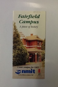
Brochure - NMIT Fairfield campus, Fairfield Campus: a piece of history, 2001
This brochure contains information on the 'new' NMIT campus at Fairfield, opened in 2001. It includes details of proposed courses and information about how to reach the campus.Tri-fold brochure with text, colour illustrations and map. fairfield, fairfield campus, nmit, -
NMIT (Northern Melbourne Institute of TAFE)
Report: Preston College of TAFE 1937-1987
10 copies A4 size pages bound with clip, with maps, by [Preston College of TAFE, Information Services Unit]preston college of tafe, reports, nmit -
 Bendigo Historical Society Inc.
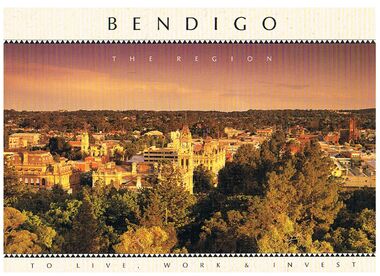
Book - BENDIGO - THE REGION TO LIVE, WORK & INVEST
Pale yellow 12 page book titled 'Bendigo the Region to Live Work & Invest'. On the front cover is a scenic view of Bendigo and on the back cover a picture of some quartz and gold nuggets on a green background. Sections in the book are: Live Work & Invest, Lifestyle, Access, Community, Infrastructure, Labour Force, Business, Opportunity, Successes and Information. Each page has a colour picture, they are:- Hargreaves Mall, Eaglehawk Golf Course, Map of Victoria, La Trobe University, Big Hill, Regional Office Department of Planning & Development, Sandhurst Farms, Construction Activity, Products of the Region, Dr. Ian Macbean, Mr Evan Jones and the Capital Theatre with information on each.book, bendigo, bendigo, bendigo - the region to live, work & invest, bendigo regional development board, dr ian macbean, mr evan jones, kate mildren, richard gibbs, express printers, hargreaves mall, eaglehawk golf course, map of victoria, la trobe university, big hill, regional office department of planning & development, sandhurst farms, construction activity, products of the region, capital theatre -
 Bendigo Historical Society Inc.
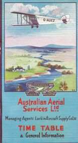
Document - BASIL WATSON COLLECTION: AUSTRALIAN FLIGHT TIMETABLES, a. & b. 1927/29; c. 1927?
Australian Flight Timetables,3 booklets: 1. Australian Aerial Services Ltd. booklet contains timetables, educational notes on aerial transport, first flight impressions, coach connections with airports, rules of the air, 1920's although no date on booklet. Aerial route map shows route from Melbourne to Hay, then to Adelaide, and east to Cootamundra. 2. AHS Timetable and general information booklet. Issued 1st March 1929, contains timetables, general information re flights, image of passengers 'emplaning' at Essendon Airport. 3. 'Fly There' booklet of timetable information and passenger fares and parcel rates. West Australian Airways.person, individual, basil watson -
 Bendigo Historical Society Inc.
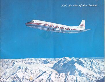
Document - MCCOLL, RANKIN AND STANISTREET COLLECTION: NAC AIR ATLAS OF NEW ZEALAND, 1955
... . Photographs, arial photographs & maps. Shows air routes. Information... & maps. Shows air routes. Information on commercial air flights ...McColl Rankin & Stanistreet, NAC Air Atlas of New Zealand. Photographs, arial photographs & maps. Shows air routes. Information on commercial air flights in New Zealand. Published by New Zealand National Airways Corp.organization, business, bendigo businesses, mccoll rankin & stanistreet, nac air atlas of new zealand -
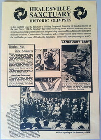 Healesville Sanctuary Heritage Centre
Flyer - program, Circa 1994
The brochure features newspaper articles and snapshots of Healesvile Sanctuary in the 1930's. This is a 4 page pamphlet printed on yellow A3 paper and folded in half. It features activities and information relating to the 60th anniversary of the Healesville Sanctuary. Print is dark green. The back page has a map and opening times of the various exhibits and "Meet the Keeper" times. Includes 3 photographs from old newspapers.healesville-sanctuary, holiday-program, 60th-anniversary, official-opening, map -
 National Vietnam Veterans Museum (NVVM)
Map, XA BINH BA (SE), 1967
Paper in map in strip form of Vietnam highlighting in red specific area of interest luscombe Field Nui Dat Overprint Information from RA SVY and Intelligence Sources Nov 67map, vietnam, ra svy -
 National Vietnam Veterans Museum (NVVM)
Poster - Poster, Information Board, Australian Army Training Team Vietnam - The Team
Yellow metal with white, black & red letterings & numbers. Some of the locations where AATTV members served. Also a map of Vietnam showing Admin Divisions & military regions, June 1967.aattv, vietnam map -
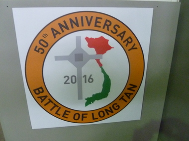 National Vietnam Veterans Museum (NVVM)
Poster - Poster, Information Board, 50th Anniversary of the Battle of Long Tan
Anniversary emblem on white board. Orange circular emblem enclosed with words '50th Anniversary Battle of Long Tan'. Centre features red and green outline map of Vietnam, Long Tan Cross and ? 201650th anniversary, battle of long tan -
 National Vietnam Veterans Museum (NVVM)
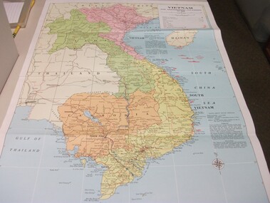
Map - Map, Vietnam and surrounding countries
Paper map of Vietnam, Laos, Thailand, Hainan Island, Cambodia & Burma. Coloured print, very detailed. Showing surrounding oceans & information on climate & population of North & South Vietnam.vietnam map -
 Dutch Australian Heritage Centre Victoria
Road Map, Nederland
Cleverly folded 1:250,000 road map produced in Dutch, French, German and English containing not only the Dutch road network but also much information of interest to tourists. It is enclosed in a brown imitation leather cover that closes with a stud. Optimal ease of use through patented Falk folding mode.Falk Plan. Road Map. Netherlands. Repeated in Dutch, French and German. -
 National Vietnam Veterans Museum (NVVM)
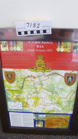
Poster - Poster, Information Board, A Field Battery RAA, South Vietnam 1971
Silver framed display board of map, photos and notes of Operation Overlord - contact 7th June, 1971A Field Battery RAA, South Vietnam 1971a field artillery, operation overlord -
 National Vietnam Veterans Museum (NVVM)
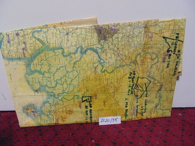
Map
... Map A large laminated coloured map of Joint Operations Graphic ...A large laminated coloured map of Joint Operations Graphic (ground), Vietnam. there are specific information highlighted in pen.3rar, mcphail collection, map -
 National Vietnam Veterans Museum (NVVM)
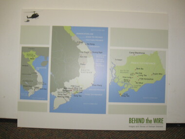
Poster - Poster, Information Board, Behind The Wire
Storybord with three maps of Vietnam showing various locations of importance such as Saigon, Nui Dat, Vung Tau, Binh Ba, Long Tan, FSB Horseshoe, An Nhut, Baria, Hoa Long and Xuyen Moc.storyboard, behind the wire, maps, saigon, nui dat, vung tau, long tan -
Clunes Museum
Document - MT BECKWORTH POST FFICE
.1 MOUNT BECKWORTH (SOMETIMES SPELLED MOUNT BECKWITH) POST OFFICE WAS OPENED ON 1ST MARCH 1863 AS A RECEIVING OFFICE. IT WAS UPGRADED TO POST OFFICE ON 7TH JULY 1927 AND CLOSED ON 14 DECEMBER 1955/ BARRED NUMERAL CANCEL 431, OF WHICH TERE ARE VERY FEW KNOWN, WAS USED AT MOUNT BECKWORTH UNTIL CIRCULAR DATE STAMPS REPLACED THEM IN 1912 POST OFFICERS AT MOUNT BECKWORTH WERE J MCLEAN 1863-1864 THOMAS DUNN 1864-1909 B DUNN 1909-1911 R. DUNN 1911-1920 MISS CAMERON 1920-1936 MISS EVELYN CAMERON DUNN 1936-1939 BERTHA AMELIA DORIS ALSTON 1939 MRS. EVELYN CAMERON ROMEO 1939-1955 .2 LETTER FROM ALEX STONEMAN SENDING INFORMATIONS ABOUT THE HISTORY OF pOST OFFICES IN THE AREA, A PHOTOCOPY OF PART OF THE RAILWAY AND POSTAL & TELEGRAPH MAP OF VICTORIAmt beckworth post office, mount beckwith post office -
Tatura Irrigation & Wartime Camps Museum
Book, Routledge Taylor and Francis Group, Fabrications, November 2016
Information about Prisoner of War and Internment Camp architecture and geography in the Pacific Carceral ArchipelagoWhite front cover with map. Pink and white spine and back coverThe Journal of the Society of Architectural Historians, Australia and New Zealand. In and Across the Pacificprisoner of war camps, internment camps, pacific carceral archipelago, anoma pieris, society of architectural historians, australia and new zealand -
Tatura Irrigation & Wartime Camps Museum
Folder - biography, Andrew Crawford 1887-1974, September 2018
The story of Andrew Crawford covering his time in the army, life before the war, his role in the war, the 8th Light Horse regiment, covering many of the battles he was engaged in, his promotions through the ranks, and life after the war. Includes many graphic photographs and maps. In the back is a copy of a letter he send his mother in September 1918. Black covered multi ring folder containing 32 plastic sleeves with typed information.andrew crawford, 8th light horse regiment, ww1 battles, anzac cove -
Tatura Irrigation & Wartime Camps Museum
Book, History of Valvers of Water Commmission of Victoria 1905 - 1994, 2014
Includes names of valvers who served in TaturaBlue and white front cover. Taken at a conference. State Rivers and Water Supply Commission map of Victoria water storage information on back covervictoria state rivers and water supply commission -
Tatura Irrigation & Wartime Camps Museum
Folder, Research Material on John West, 2003
... Irrigation and orchardist, Ardmona. Contains, also a map of Ardmona..., Pioneer Irrigation and orchardist, Ardmona. Contains, also a map ...Research material for a Thesis on John West, Pioneer Irrigation and orchardist, Ardmona. Contains, also a map of Ardmona irrigation information from local newspapersBlue plastic cover, black binding on spine. Hand written labelirrigation, books, rural, industry -
Tatura Irrigation & Wartime Camps Museum
Booklet, The Streets and Parks of Mooroopna, 1999
Produced to ensure accurate recording of information re town of Mooroopna. Maps and street names and parkland included. Dedicated to the memory of the Late Jean Anselmi (1916-1998)Green card cover with photograph of McLennan (Main) Street of Mooroopna early1900's.mooroopna victoria, mooroopna streets, mooroopna parklands, jean anselmi -
Tatura Irrigation & Wartime Camps Museum
Booklet, History of the Waranga Basin, 1989 (reprint)
Includes details of construction of Waranga systemBuff soft covered book with map of Waranga Basin and text in brown Written by Joyce Hammond giving historical information from aboriginal presence to the situation in 1977 with reference to members of the Gunn and Hammond familiesirrigation, boat club, books, history, local -
Tatura Irrigation & Wartime Camps Museum
Folio, James Winter of Dhurringile, 1994
Historical report illustrated by maps and written material from various sourcesFolder containing information on James Winter of Dhurringile.dhurringile, documents, reports -
Tatura Irrigation & Wartime Camps Museum
Book, Girgarre Living History, Girgarre. Girgarre Living History, 2016
Girgarre - an extraordinary history, closer settlement, soldier settlement and family stories.Tells of the history of Girgarre, with information obtained from a collection of stories and extensive research into the Closer and Soldier Settlement of the districtRectangular shaped book ,aerial photo of the township and environs of Girgarre, on Market Day, September 2013. Photo extends over front & back covers, highly colourful cover. 251 pages. B/W photos and maps of local families and local scenes.girgarre, family histories, soldier settlement -
Tatura Irrigation & Wartime Camps Museum
Folder, The Mighty Murray, 1993
Compiled by a group of teachers. Based on original concept by David Eastburn. Distributed as a teachers' aid. Assists in research developing their ability to formulate and test hypothesesRiver scenes (Murray and Darling). Educational information.|Includes aboriginal early population to present day settlement. Early map 1902the mighty murray, murray darling basin, huggan h, tatura, water, documents, education -
Tatura Irrigation & Wartime Camps Museum
Book, Girgarre Living History, Girgarre. Girgarre Living History, 2016
Girgarre - an extraordinary history, closer settlement, soldier settlement and family stories.Tells of the history of Girgarre, with information obtained from a collection of stories and extensive research into the Closer and Soldier Settlement of the districtRectangular shaped book ,aerial photo of the township and environs of Girgarre,on Market Day, September 2013. Photo extends over front & back covers, highly colourful cover. 251 pages ,B/W photos and maps of local families and local scenes.girgarre, family histories -
Tatura Irrigation & Wartime Camps Museum
Booklet, History of the Waranga Basin, 1989 (reprint)
Includes details of construction of Waranga systemBuff soft covered book with map of Waranga Basin and text in brown Written by Joyce Hammond giving historical information from aboriginal presence to the situation in 1977 with reference to members of the Gunn and Hammond familiesirrigation, boat club, books, history, local -
 Robin Boyd Foundation
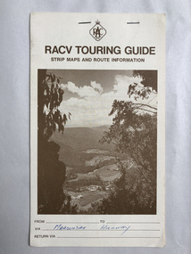
Map, RACV, RACV Touring Guide
... Strip maps and route information for via the Maroondah... melbourne Walsh St library In blue pan Maroondah Highway. Strip maps ...Strip maps and route information for via the Maroondah Highway from melbourne to benalla.In blue pan Maroondah Highway.walsh st library -
 Victorian Aboriginal Corporation for Languages
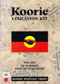
Kit, Koorie education kit, 1995
Koorie cultural heritage is introduced in lesson form. For use in schools Prep to Year Eightmaps, b&w photographs, b&w illustrations, cartoons, colour photographs, A4-sized information cardskoorie culture and education, primary school education, koorie history