Showing 44519 items
matching land-conservation-east-gippsland
-
 Lakes Entrance Regional Historical Society (operating as Lakes Entrance History Centre & Museum)
Book, Content Pty Ltd, Ships that sailed the Gippsland Lakes, 2005
A comprehensive study concerning the interation of people and the environment in the East Gippsland Shire. Subjects are covered from exploration and settlement to government, administration and cultural development.environment, township -
 Ringwood and District Historical Society
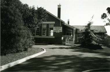
Photograph-B&W, Joan Walker, East Ringwood 2000- Formerly the East Ringwood Primary School No 4680, 2000
East Ringwood 2000- Formerly the East Ringwood Primary School No 4680- B&W Photo from Album 6501 -
 Ringwood and District Historical Society
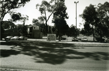
Photograph-B&W, Joan Walker, East Ringwood 2000-Maroondab Club & East Ringwood Football Ground, 2000
East Ringwood 2000-Maroondab Club & East Ringwood Football Ground- B&W Photo from Album 6501 -
 Ringwood and District Historical Society
Photograph-B&W, Joan Walker, East Ringwood 2000-3rd Ringwood East Scouts in 'Knaith Park', 2000
East Ringwood 2000-3rd Ringwood East Scouts in 'Knaith Park'- B&W Photo from Album 6501 -
 Whitehorse Historical Society Inc.
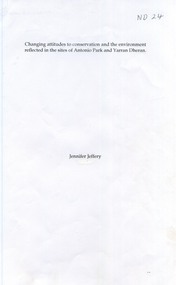
Book - Report, Changing attitudes to conservation and the environment reflected in the sites of Antonio Park and Yarran Dheran, 1997
A carefully documented essay on the history of Antonio Park and Yarran Dheran as examples of changes in public attitude to conservation.A carefully documented essay on the history of Antonio Park and Yarran Dheran as examples of changes in public attitude to conservation. References are made to the Aboriginal uses of the land, the roles of the Schwerkolt and Antonio families, the Nunawading City Council and the establishment of Antonio Park Primary School. The importance of appropriate botanic species is stressed. 14 pages. Includes bibliography.A carefully documented essay on the history of Antonio Park and Yarran Dheran as examples of changes in public attitude to conservation. antonio park, mitcham, yarran dheran, antonio family, mullum mullum creek, environment -
Lakes Entrance Regional Historical Society (operating as Lakes Entrance History Centre & Museum)
Book, Cunningham Cliff, Aboriginal Scar Tree Bruthen Valley, 2004
Research interpretation and management recommendations for the Aboriginal Scar tree in Bruthen Valley, East Gippsland Victoria by a forestec studentaboriginals, transport, vegetation -
Lakes Entrance Regional Historical Society (operating as Lakes Entrance History Centre & Museum)
Photograph, 1910 c
Group appear to be on a Sunday excursion as all in best clothesBlack and white photograph of group of men, women and children posed for the camera in a bush setting in East Gippsland Victoriacelebrations, clothing -
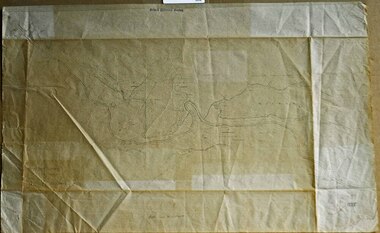 Orbost & District Historical Society
survey sheet, circa 1870's
E.L. Bruce, born in Ireland on July 1,1854, came to Australia in 1854 and joined the Lands Department. He spent most of his service in Gippsland. The journey to Sale then was made by ship to Port Albert and thence on horseback. He began his service in Gippsland as assistant district surveyor and for the last 12 years before retirement he was district surveyor and land officer. His territory extended from the boundary of Victoria in east Gippsland down to Wilson's Promontory with his headquarters at sale.This map is a useful reference tool.A survey map - Sheet No 3 SnowyRiver Survey. This is a copy of the original survey. It shows the properties of W.J.T. Clarke - two in Orbost and one in Newmeralla (sic),. it has a faded, undecipherable red stamp in the bottom right corner.Gipps Land Rivers No 32B E.L. Brucesurvey bruce-e.l snowy-river-c19th -
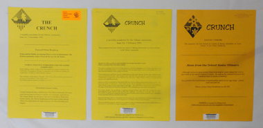 Orbost & District Historical Society
newsletters, The Crunch, 1995 1996
These newsletters were created as an ACCESS project at the Orbost centre of TAFE (Technical and Further Education). Community newsletters are published by local groups and provide community news and information. In small rural communities they are an important communication medium.Three issues of a newsletter titled The Crunch. This was a newsletter for the Orbost community and contains articles on Orbost events. Most articles refer to TAFE Outreach Services. 2407.1 and 2407.2 are printed on yellow paper. 2407.3 has 3 orange sheets and 2 yellow sheets. All are stapled. 2407.1 has a label on the front with East Gippsland Shire Library and a bar code. 2407.2 has a bar code and LOCAL Newsletter written in pencil. 2407.3 has a stamp - EAST GIPPSLAND LIBRARY SERVICE and LOCAL written in pencil.newsletters tafe-orbost -
Stawell Historical Society Inc
Book - Report, Shire of Stawell, Local Conservation Strategy, 1990
Photos of Steering Committee and Support Staff. Shire Map Photos, Maps.Grey Cardboard cover with Shire LogoBarry Clugston Shire of Stawell with Logo - Local Conservation Strategy -
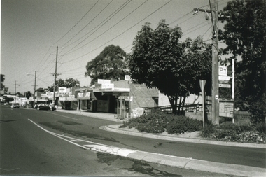
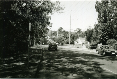 Ringwood and District Historical Society
Photograph-B&W, Joan Walker, East Ringwood 2000-Railway Avenue looking East to the junction of Victoria Street, 2000
East Ringwood 2000-Railway Avenue looking East to the junction of Victoria Street- B&W Photo from Album 6501 -
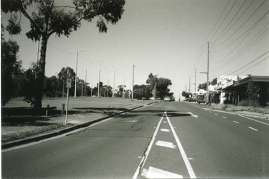
 Ringwood and District Historical Society
Photograph-B&W, Joan Walker, East Ringwood 2000-Railway Avenue looking East from Laurence Grove, 2000
East Ringwood 2000-Railway Avenue looking East from Laurence Grove- B&W Photo from Album 6501 -
 Ringwood and District Historical Society
Photograph-B&W, Joan Walker, East Ringwood 2000-Railway Avenue looking East from Laurence Grove, 2000
East Ringwood 2000-Railway Avenue looking East from Laurence Grove- B&W Photo from Album 6501 -
 Ringwood and District Historical Society
Photograph-B&W, Joan Walker, East Ringwood 2000-Railway Avenue Looking East from Dublin Road, 2000
East Ringwood 2000-Railway Avenue Looking East from Dublin Road- B&W Photo from Album 6501 -
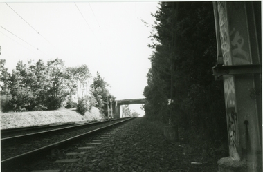 Ringwood and District Historical Society
Photograph-B&W, Joan Walker, East Ringwood 2000-Eastfield Road Bridge looking West To East Ringwood, 2000
East Ringwood 2000-Eastfield Road Bridge looking West To East Ringwood- B&W Photo from Album 6501 -
 Ringwood and District Historical Society
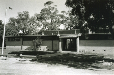
Photograph-B&W, Joan Walker, East Ringwood 2000-Maroondab Club in Mount Dandenong Road Ringwood East, 2000
East Ringwood 2000-Maroondab Club in Mount Dandenong Road Ringwood East- B&W Photo from Album 6501 -
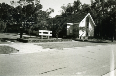 Ringwood and District Historical Society
Photograph - Photograph-B&W, Joan Walker, East Ringwood 2000-St Stephens Uniting Church in Freeman Street East Ringwood, 2000
East Ringwood 2000-StStephens Uniting Church in Freeman Street East Ringwood- B&W Photo from Album 6501 -
Whitehorse Historical Society Inc.
Document, Purchase of land by Robert Collier, 1905
Invoice for cost of survey of land near Tunstall Station.Invoice for cost of survey of land near Tunstall Station to be purchased by Robert Collier from Victorian Railway Commissioners, with application for land to be brought under Transfer of Land Act 1890.Invoice for cost of survey of land near Tunstall Station.collier, robert, land sales, tunstall -
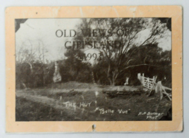 Orbost & District Historical Society
calendar, Old Views of Gippsland 1993, 1992
This item is a useful pictorial reference tool.A 1992 stapled pictorial annual calendar, titled "Old Views of Gippsland".On the front is a black/white photograph of "The Hut Belle Vue" taken by H.D. Bulmer. It contains early photographs of East Gippsland, one for each month. The photographs are sepia. There is a hole for hanging. Some dates have appointments recorded in pen.calendar-old-views-of-gippsland photographs-historic-gippsland -
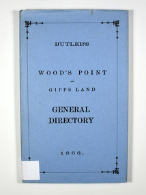 Marysville & District Historical Society
Book, Butler's Wood's Point and Gipps Land General Directory 1866, 1985
A directory of the local businesses, road guides and table of distances in the Wood's Point, Jamieson, Omeo and Bairnsdale areasHardback. Blue dust cover. Title in black on the front cover.Stamp of the Marysville & District / Historical Society Inc / P.O. Box 22 / Marysville 3779directory, wood's point, gippsland, victoria, history, jamieson, bairnsdale, omeo, road guide, table of distances, advertisements -
Lakes Entrance Regional Historical Society (operating as Lakes Entrance History Centre & Museum)
Book, LERHS, Gippsland Comprehensive Regional Assessment, 2000
Reminiscences of three men who spent most of their lives working in forests recording incidents and personalities over approximately forty years East Gippsland Victoriatimber industry, emergency services -
 Whitehorse Historical Society Inc.
Photograph, Springvale Road East Burwood
The Tally Ho Business Park was built on vacant land previously owned by the Methodist Church. The land was sold cheaply to the Church by Abel Hoadley, and the Tally Ho Boys Home was erected there. A change in the care of the boys meant that the land became vacant for a considerable time before buildings appeared. The Country Fire Authority, Vic Roads and World Vision are also located there.4 coloured photographs (a-d) taken at the intersection of Springvale Road & Burwood Hwy East Burwood. First stages of the Tally Ho Business Park in the background.tally ho business park, businesses -
Lakes Entrance Regional Historical Society (operating as Lakes Entrance History Centre & Museum)
Book, Victorian Heritage Council, Public Heritage Program Review for heritage conservation, 2000
A brief strategy providing direction for identification, protection, conservation and management of Victoria's diverse cultural heritage.heritage -
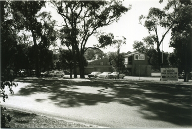
 Ringwood and District Historical Society
Photograph-B&W, Joan Walker, East Ringwood 2000-East Ringwood Tennis Courts and the Cnr: Mount Dandenong & Dublin Roads, 2000
East Ringwood 2000-East Ringwood Tennis Courts and the Cnr: Mount Dandenong & Dublin Roads.- B&W Photo from Album 6501 -
 Bendigo Military Museum
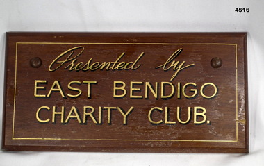
Plaque - EAST BENDIGO PLAQUE
This belonged to East Bendigo Honour Board WW2 held at this museum. Not yet catalogued.A varnished wooden plaque. It has gold painted lettering with dark printed shadow effect. It has curved edging. It is rectangular shaped.“Presented by East Bendigo Charity Club”war, east bendigo, honour boards -
Lakes Entrance Regional Historical Society (operating as Lakes Entrance History Centre & Museum)
Photograph, Lakes Post Newspaper, 1995
Black and white photograph of Kath Gasden Coast Action Co-Ordinator summer 1994/95 for East Gippsland Victoriagippsland ports, people -
Lakes Entrance Regional Historical Society (operating as Lakes Entrance History Centre & Museum)
Book, Cox, Rev. George, Notes on Gippsland History Vol. 2. The Beginnings of Gippsland, 1990
An edited version of Rev. George Coxs Notes on Gippsland History which appeared in Gippsland Standard from 1911 to 1930, this volume dealing with the years 1840 to 1841periodicals -
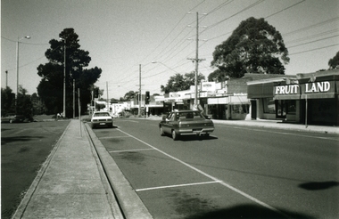
 Ringwood and District Historical Society
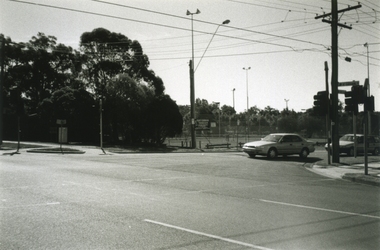
Photograph-B&W, Joan Walker, East Ringwood 2000-The East Ringwood Railway Station from the car park opposite IGA Supermarket, 2000
East Ringwood 2000-The East Ringwood Railway Station from the car park opposite IGA Supermarket- B&W Photo from Album 6501 -
 Ringwood and District Historical Society
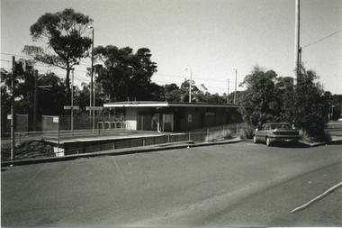
Photograph-B&W, Joan Walker, East Ringwood 2000-Taken from the Eastfield Road Bridge looking towards the East Ringwood Station, 2000
East Ringwood 2000-Taken from the Eastfield Road Bridge looking towards the East Ringwood Station- B&W Photo from Album 6501 -
Lakes Entrance Regional Historical Society (operating as Lakes Entrance History Centre & Museum)
Book, Clements, Eddie and Shepherd, Keith White, Lee, Around the Campfire Ashes. Tales of Old Gippsland, 1986
Stories of people and places of East Gippsland, as recalled by two men who spent schooldays at Bruthen, and many years camping in the bush and enjoying the company of local residents.Ruth Clarktownship