Showing 1290 items
matching lands
-
 Bendigo Historical Society Inc.
Map - JACK FLYNN COLLECTION: GOORNONG, August 1953
Map: Township of Goornong, Parish of Goornong, County of Bendigo. Parish plan.By Authority W.M. Houston. Government Printer. Drawn and Reproduced at the Dept., of Lands and Survey, Melbourne, Victoria. August 1953map, bendigo, township, goornong -
 Bendigo Historical Society Inc.
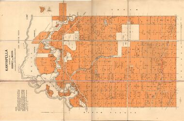
Map - JACK FLYNN COLLECTION: KANYAPELLA, 22/05/1939
Map: Parish of Kanyapella, Counties of Rodney and Moira. Parish plan.By Authority, T. Rider Acting Govt, Printer Melbourne. Drawn and Reproduced at the Dept. of Lands and Survey, Melbourne, Victoria.map, moira, parish plan, kanyapella, counties of rodney and moira -
 Clunes Museum
Map - MAPS, A.C. BROOKS GOVERNMENT PRINTER MELBOURNE
.1 PARISH OF CLUNES, COUNTY OF TALBOT. (3 COPIES) (1) STAMP: DRAWING OFFICE RECORDS COPY, STATE ELECTRICITY COMMISSION OF VICTORIA. ELECTRICITY DEPARTMENT (THIS PLAN MUST NOT BE TAKEN FOR FIELD USE. PLEASE DO NOT DEFACE) C71 ON LEFT BOTTOM CORNER, CLUNES SHEET 1 (2) '19' HANDWRITTEN ON ALL FOUR CORNERS AND PLASTIC TAB FOR HANGING (3) PLASTIC TAB FOR HANGING .2 MAP BECKWORTH COUNTY OF TALBOT (3 COPIES) (1) IN RED: B-61. L.4855. THE ALLOTMENTS COLOURED BROWN ARE FREEHOLD (2) WITH PLASTIC TAB FOR HANGING (3) WITH PLASTIC TAB FOR HANGING. '14' HAND WRITTEN IN ALL 4 CORNERS AND VARIOUS PENCIL NOTATIONS ON THE MAP..1.2 DRAWN AND REPRODUCED AT THE DEPARTMENT OF LANDS & SURVEY MELBOURNE. PRICE 2/- .1 IN PENCIL ON BOTTOM ' 211 ' 20%parish of clunes, electricity supply department, beckworth -
 Kiewa Valley Historical Society
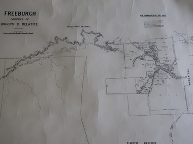
Map - Freeburgh - Counties of Bogong and Delatite
Drawn and reproduced at the Dept. of Lands and Survey, Melbourne, Victoria November 1948Black and white map of Freeburgh, County of Bogong and Delatitefreeburgh, map county of bogong and delatite -
Tatura Irrigation & Wartime Camps Museum
Book, Register of Land 1955-1956, 1955
Register of Lands in Tatura district with apportioned water rights 1955-56Beige covers, red spine, black lettering. Rodney Irrigaton and Water Supply District 28.10.1955.farming and irrigation, books, irrigation, rural, industry -
 Bendigo Historical Society Inc.
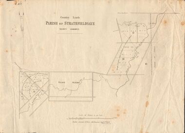
Document - MARKS COLLECTION: MAP OF PARISH OF STRATHFIELDSAYE 1858, 8th September, 1858
Buff coloured document. On top 'Country Lands, Parish of Strathfieldsaye, County Unnamed'. On bottom 'Scale 40 chains to an inch. Public Lands Office, Melbourne Sept 8th. 1858. William Collis, Lith ( lithographer )'. Map shows Village Reserve on Emu Creek, road from Sandhurst, Sheepwash Creek and Splitters Creek. Wellington Hotel marked on map near intersection of Sheepwash Creek, Axe Creek and Emu Creek. Axe Creek Pound near Splitters Creek.map, bendigo, parish of strathfieldsaye 1858 -
 Bendigo Historical Society Inc.
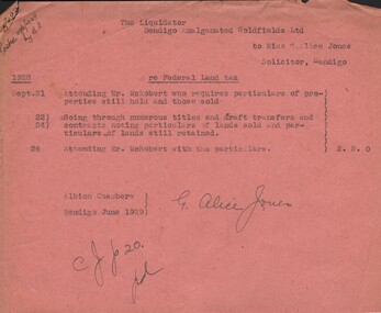
Document - MISS G ALICE JONES COLLECTION: ACCOUNT
The Liquidator Bendigo Amalgamated Goldfields Ltd to Miss G. Alice Jones. Re Federal Land Tax. Pink paper dated. 21, 22, 24, 26 1928 and June 1929. Account includes particulars of properties still held and those sold, going through titles and draft transfers and contracts noting particulars of lands sold and of lands still held. Cost £2.2.0. "R492 Posted 29/6/1929 by B.F?" written in the top left corner.the miss g. alice jones collection - account, bendigo amalgamated goldfields ltd, mr mcrobert -
 Bendigo Historical Society Inc.
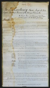
Document - 1856 PETITION OF CROWN LAND OCCUPANTS AT SANDHURST
Original petition from Sandhurst Crown Lands occupants to Major General Macarthur, Acting Governor of the colony of Victoria, seeking consideration for the improvements they had made on the lands they occupied under business licenses. Pages of document have been conserved, stored in individual pockets. Eighteen pages of parchment and paper containing signatures, addresses and occupation of 1,387 storekeepers, publicans, miners, professionals and persons in various types of employment. Cr. Alec Craig donated this item in 1959, to the Bendigo Historical Society.bendigo, history, 1856 crown land occupants petition, bendigo petition -
Bendigo Historical Society Inc.
Map - WELLSFORD : COUNTY OF BENDIGO, 6-10-03
Map. Wellsford, County of Bendigo, Bagshot, Ellesmere, Axedale, Hunty, Sandhurst, Strathfieldsaye. Photo-Lithograph ed at the Department of Lands and Survey Melbourne. 6-10-03. (number 21 in map cupboard 1)T.E. McGearsonmap, bendigo, wellsford -
University of Melbourne, Burnley Campus Archives
Plan, Plan of Richmond Park, 1872
Plan of Richmond Park L4461. Shows Horticultural Society's Garden without extra land used for Field Station (see 11.0363, but earlier). Photo-lithographed at the Department of Lands and Survey, 6th Sept. 1872.Handwritten notes on reverse and another railway line marked in pencil.richmond, parks, field station -
 Bendigo Historical Society Inc.
Map - Parish of Strathfieldsaye
Map owned by Henry Thomas (Jack) Qualtrough who worked for the Victorian Forestry Commission. Shire of Strathfieldsaye County of Bendigo canvas backed map. L5169. Includes Axedale, Kimbolton, Eppalock and Sedgewick. Photographed/Lithographed for the Department of Lands and Survey Melbourne by T E McGauran 24.3.07. Price 1/-.map, axedale, kimbolton, sedgewick, eppalock -
 Lara RSL Sub Branch
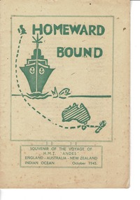
Booklet, Homeward Bound - Souvenir of the voyage of H. M. T. Andes. Oct. 1945, Circ. 1945
A brief history of the effort made to return Air Force Personnel to their home lands.WW2 article voyage home of service personnel.Pamphlet - Homeward Bound - Souvenir of the voyage of H.M.T. 'Andes' Oct 45 Cover has green printing of title, ship, U.K. image and a dotted line showing journey to Australia - New Zealand.In the middle of the Booklet is an autographs section. Autographs are from fellow ship board travelers. -
Ringwood and District Historical Society
Commercial papers, Aird, J.G, Papers re Land Purchases and transfers between J.G.Aird and others 1919-1924, 1919-1924
Details of monies paid to J.G. Aird and handled by him in connection with the sale of lands.2 bundles of papers pertaining to the collection of monies involved in land purchases and transfers between Mr. J.G. Aird and other parties stapled together in brown folder. +Additional Keywords: Aird, J.G. -
Tatura Irrigation & Wartime Camps Museum
Book, Dr W.H.Bossence, Dhurringile
History of settlers and lands owned by Winter-Irving and their descendants in the early 1800'sHistory of early settlersNo cover. white sheets of paper, black printing. Pages stapled together. Typed and photocopied. 17 pagesOn front sheet "Belongs to Tatura and District Historical Society" -
 Ringwood and District Historical Society
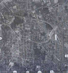
Photograph, Aerial photograph of Heathmont, Victoria - c.1960s, 1975
Aerial view of Heathmont - black and white photograph on chipboard backing. (Protected by slightly damaged plastic cover which could be removed for clearer image.)Department of Crown Lands and Survey Melbourne, Project Run 31A 27-12-1975, Lens 209 1951M ASL. -
 Bendigo Historical Society Inc.
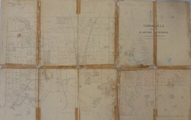
Map - JACK FLYNN MAP COLLECTION: GLADSTONE AND BENDIGO - TARNAGULLA, 13th May 1922
Map 388. Counties of Gladstone and Bendigo a Map of Tarnagulla with Kingower, Glenalbyn, Inglewood, Waanyarra and Laanecoorie boarding. The map is in poor condition and in several pieces. It has been previously taped together. The front page is of red card with white tape along the spine to hold it together, top half Tarnagulla is hand written in black lead on a label with blue trim.By Authority A.J. Mullett, Government Printer, Melbourne. Photo-Lithographed at the Department of Lands and Survey, Melbourne by W.J. Butson. 13.5.22map, bendigo, tarnagulla, tarnagulla, kingower, glenalbyn, laanecoorie, inglewood. -
 Bendigo Historical Society Inc.
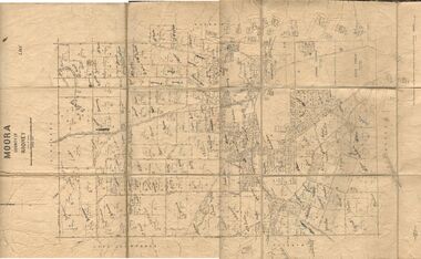
Map - JACK FLYNN COLLECTION: MOORA, 9/10/22
Map: Parish of Moora, County of Rodney. Parish plan.By Authority A.J. Mullet Government Printer Melbourne. Photo Lithographed at the Dept, of Lands and Survey, Melbourne by W.J. Butson. 3.10.22map, rodney, parish plan, moora -
 Bendigo Historical Society Inc.
Map - JACK FLYNN COLLECTION: BONN, 16/07/1919
Map: Parish of Bonn, County of Rodney. Parish plan.By Authority A. J. Mullett. Government Printer, Melbourne. Photo Lithographed at the Department of Lands and Survey. Melbourne by W. J. Butson.map, rodney, parish plan, bonn, rodney -
 Bendigo Historical Society Inc.
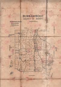
Map - JACK FLYNN COLLECTION: BURRUMBOOT, August 1951
Map: Parish of Burrumboot, County of Rodney. Parish plan.By Authority J.J. Gourley, Government Printer Melbourne. Drawn and Reproduced at the Dept of Lands and Survey, Melbourne, Victoria. August 1951map, rodney, parish plan, burrumboot, rodney -
 Bendigo Historical Society Inc.
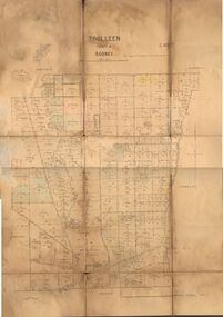
Map - JACK FLYNN COLLECTION: TOOLLEEN, 25/05.1926
Map: Parish of Toolleen, County of Rodney. Parish plan.By Authority, H.J. Green. Govt., Printer. Photo-Lithographed at the Department of Lands and Survey Melbourne. W. J. Butson 25.5.26.map, rodney, parish plan, toolleen -
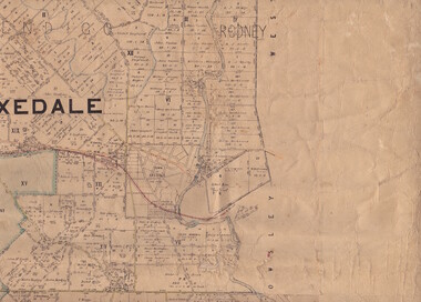
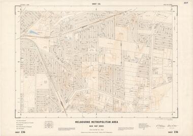 Ringwood and District Historical Society
Map - Melbourne Metropolitan Area Base Map Series, Sheet 236 - Ringwood area, 1961
Map prepared by Dept of Lands and Survey and MMBW from State Aerial Survey June 1957 and Cadastral Survey information May 1961. This sheet comprises parts of the Municipalities of Croydon and Ringwood, and Parishes of Ringwood and Warrandyte.Scale: 400 feet to 1 inch. Contours at 5 feet vertical interval. By Authority: A.C. Brooks, Commonwealth Printer, Melbourne. -
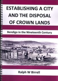 Bendigo Historical Society Inc.
Book - ESTABLISHING A CITY AND THE DISPOSAL OF CROWN LANDS
Establishing a city and the disposal of Crown lands, Bendigo in the Nineteenth century, 153 pages with maps,illustrations, black & white and some coloured photographs. Spring bound with plastic cover. Published and printed by Bendigo Historical Society.Ralph W Birrellbendigo, history, land sales -
Bendigo Historical Society Inc.
Map - PANNOOMILLOO : COUNTY OF BENDIGO, 17-12-13
Map. Pannoomilloo, County of Bendigo, Pannoobamawm, Warragamba, Milloo, Diggorra. Photo-Lithographed at the Department of Lands and Survey, Melbourne by W.J. Butson 17-12-13, Price 1/-. (number 82 in map cupboard 1)W.J. Butson.map, bendigo, pannoomilloo -
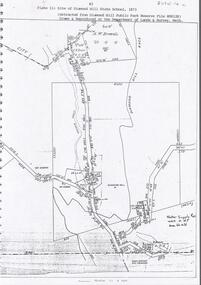 Bendigo Historical Society Inc.
Document - DIAMOND HILL STATE SCHOOL SITE
Map (copy) showing the site of Diamond Hill State School, 1873. On top of page 'extracted from Diamond Hill Public Park Reserve File RS8128, drawn and reproduced at the Department of Lands and Survey, Melbourne'bendigo, education, diamond hill state school -
Bendigo Historical Society Inc.
Map - CAMPBELL COLLECTION: BENDIGO AND DISTRICT MAPS, 1959
Map. Huntly, County of Bendigo, Neilborough, Bagshot, Nerring, Wellsford, Sandhurst. Township of Huntly. By Authority A.C. Brooks, Government Printer Melbourne. Drawn and reproduced at the Department of Lands and Survey, Melbourne, 1958. Price 5/-.A.C. Brooks, Government Printermap, bendigo, allotments -
 Whitehorse Historical Society Inc.
Document - Report, Nunawading land, 01/10/1855
Photocopies of 3 sheets of documents in the Public Record Office listing the first land purchases in Nunawading. Headed: 'Final Report of a sale by public auction of suburban and country lands held at Melbourne on the 22nd October 1855'.williams, william, cousens, james, heading, nalborough, phillip, riley, patrick, blood, thomas, cook, holland, john, lobb, burrell, charles, land subdivision -
Bendigo Historical Society Inc.
Map - PANNOOBAMAWM : COUNTY OF BENDIGO, 1957
Map. Pannoobamawm, County of Bendigo, Terrick Terrick East, Wanurp, Pannoomilloo, Bamawm, Turrumberry, property allotments. Drawn and reproduced at the Department of Lands and Survey, 1957, Price 2/-. (number 410 in Map Cupboard 1 ).W.M. Houston, Government Printer, Melbourne.bendigo, hospital -
Bendigo Historical Society Inc.
Map - NERRING : COUNTY OF BENDIGO, August 1952
Map. Nerring, County of Bendigo, Leichardt, Marong, Sandhurst, Huntly, Neilborough, Yarraberb. Drawn and Reproduced at the Department of Lands and Survey, Melbourne, Victoria, August 1952, Price 2/-.( number 409 in Map Cupboard 1).J.J. Gourley, Government Printer, Melbourne.bendigo, hospital -
Stawell Historical Society Inc
Book - Report, Grampians National Park Draft Management Plan, 1985
For Public comment to National Park Service, Victoria. A Division of the department of Conservation, Forest and LandsSoft Cover with B/W Photo of aerial view of ranges of Grampians. Black taped Spine binding.$5 Barry Clugston -
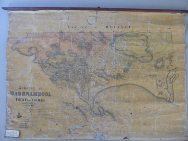 Warrnambool and District Historical Society Inc.
Mao, Borough of Warrnambool, County of Villiers, 1873
This is an early map of the Borough of Warrnambool (1872/3) showing the central town area of Warrnambool and the surrounding district. Reserves, public buildings and some businesses are marked. The map was photolithographed by John Noone, a Melbourne artist and photographer who claimed in 1858 to have the oldest-existing photographic studio in Melbourne. Photolithography was a process first developed in Melbourne. For several years Noone was the official photographer for the Victorian Crown Lands Office and for the Victorian Public Library and Museum. The map has the stamp of the seller of the map – Charles Hider, the well-known stationer and bookseller in Timor Street, Warrnambool. The owner of the map, Henry George Marfell, (1883-1962) was the son of John and Mary Ann Marfell. The Marfells were well-known in Warrnambool as grain merchants and managers of the Warrnambool Co-Operative Milling Company. It is surmised from the writing on the Marfell label that this map was at some stage given by Henry Marfell to the old Warrnambool MuseumThis map of early Warrnambool is of considerable significance, firstly because its original state and early date (1873) make it of antiquarian and historical interest. Also the connection with the names, Charles Hider and Henry Marfell and the old Museum gives it added provenance and interest.This is a wax paper map mounted on cloth. At the top it is attached by nails to a piece of wood and at the top it has a cloth ring for hanging the map. The map is in black shadings on a yellow background. The map is badly creased and coming away from the cloth at the edges and at other various points. There is some red or pink marking or staining on the township area of the map (originally the sold lands on this map were coloured in brown and the reserves, buildings, etc in pink). On the left hand corner there is a piece of paper glued on with some handwriting in ink (Marfell). There is also the stamp of the seller of the map – Charles Hider, stationer and bookseller, of Timor Street Warrnambool‘Early Map of W’bool, H.G. Marfell’ history of warrnambool, charles hider, henry marfell