Showing 441 items
matching lands, victoria
-
 Marysville & District Historical Society
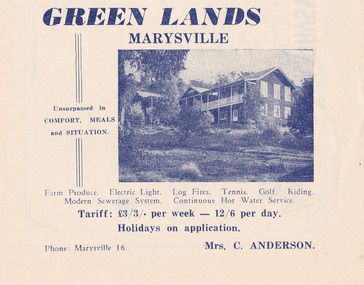
Ephemera (Item) - Advertisement, GREEN LANDS MARYSVILLE, Unknown
An advertisement for Green Lands guest house in Marysville.An advertisement for Green Lands guest house in Marysville.marysville, victoria, australia, greenlands, the spot, green lanes, sarah mclean, murdock mclean, geoffrey cobb, cath m anderson, mr and mrs a.g. clarke, e pigdon, bert patterson, guest house, advertisement -
 Ringwood and District Historical Society
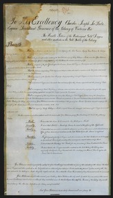
Document - Department of Lands and Survey, Wire Netting Branch, Melbourne, Victoria, Application for Vermin-Proof Fence Certificate - L.J. Mills vs John Collins, Grandview Grove, Ringwood, Victoria - 1939
Photocopied file of corresponence and documentation relating to a claim by L.J. Mills, Nurseryman, that adjoining property owner, J. Collins, Farmer, assists with replacement of a vermin proof wire netting dividing fence destroyed by 1939 bushfire. File includes 1939 and 1940 detailed property inspection reports by Vermin and Noxious Weeds Branch, Lands Department, Lilydale, describing land use in the area and signs of vermin activity. Application approved 18th April, 1940. Appeal lodged by Mr Collins disallowed in May, 1940. File closed June, 1940 with Departmental suggesion that Mr Mills consider further legal action through a Solicitor as fence had still not been wire-netted. TRANSCRIPTS: Vermin & Noxious Weeds Inspection Reports "19/9/1939 (To) Superintendent (Department of Lands and Survey, Melbourne) Re L.J. Mills application for Vermin Proof Fence. I called on Mr Mills yesterday 18th instant in connection with this matter. Mr Mills has a flower farm and claims that rabbits and hares are damaging his flowers. He showed me a bed of carnations which he stated were being damaged by rabbits. There was evidence of some leaves being nipped off, but I am unable to say whether this is due to rabbits or grubs. Very little if any real damage is being done. The property is netted on the east and south boundary and on half the north and west boundary. The surrounding country is undlating and fairly steep in places. The land to the east across Grandview Avenue (sic) is all planted out in old established orchards and well cultivated. Cleared grass land adjoins the south boundary and bush land adjoins the north and west boundaries. I walked over a large area surrounding Mr Mills land and never saw any rabbits or hares or any indications of rabbits. This locality is not rabbit infested and very little wire netting is being used. I do not consider that a vermin proof fence is necessary between these allotments. - Jas H Allison (Inspector, Vermin and Noxious Weeds Branch, Lands Department, Lilydale)." Follow up report following renewal of application for Certificate by Mr Mills, citing rabbits causing considerable damage to his flowers. He laid poison and obtained 9 carcases and stated that there is evidence of rabbit infestation from the adjoing land. "19/3/1940 (To) Mr Hannah (Superintendant, Department of Lands and Survey, Melbourne) Re L.J. Mills, Grandview Grove Ringwood, Lot 4 Grandview Estate Pt CG20 Ph of Warrandyte. I interviewed Mr Mills at his home on 15th inst. He showed me carcases of rabbits which he stated had been poisoned on his land. In places young plants had been nipped off apparently by rabbits. I made an inspection of adjoining properties and found one live burrow close to Mr Mills northern boundary. There were scratches and other evidence of rabbits on land north and west of Mr Mills property. In view of the present evidence of rabbits I consider that a vermin proof fence is now necessary to protect the flowers grown by Mr Mills. His land is netted on whole of east and south boundary and half way on west and north boundary. The adjoining land on west and north boundaries is owned by Mrs Linda Collins and John Collins resp of Brysons Road East Ringwood. - Jas H Allison (Inspector, Vermin and Noxious Weeds Branch, Lands Department, Lilydale)." -
 Bendigo Historical Society Inc.
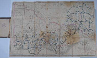
Document - HARRIS COLLECTION: HAMS SQUATTING MAP OF VICTORIA, PORT PHILLIP DISTRICT, NSW
Thomas Ham was a cartographer, engraver, lithographer and publisher in Victoria and Queensland. He compiled and printed several editions of his squatting map, beginning with A map of Australia Felix in 1847 and changing its title to Ham's squatting map of Victoria in 1851. The 1851 edition was accompanied by a key listing the names of all the squatters within squatting districts and counties. Later editions show the existing counties, but some areas of Gippsland and the Australian Alps are still described as 'unsurveyed country'. (State Library Victoria https://www.slv.vic.gov.au/squatting-map-victoria)Folding map enclosed in burgundy cover. Map backed by cloth and bound. Rare, early map of Victoria and neighbouring Port Phillip District of New South Wales. Written on bottom RH corner of map: Ham's Squatting Map of Victoria ( Port Phillip District, New South Wales ) carefully corrected to this date from the Colonial Government Surveys, Crown Lands, Commissioners & Explorers Maps, Private Surveys & c. Respectfully inscribed (with permission ) to His Excellency Sir Chas A. Fitz-Roy Knt, Governor of New South Wales &c &c by his Obedient Servant, The Compiler, 1851. Compiled, engraved and published by Thomas Ham, Melbourne. Proposed and original boundary ( in legend) have been coloured in in blue and pink ink ( later addition ?) Number on map show 'reference to proprietor's Printed on back of map ' J.G. AD 1852, with two cross hatched decorations and two hearts entwined. On other back panel in pencil enclosed in a drawn frame ' G.S.H., 1889, Axedale' (George Harris, Axedale, belongs in Harris Collection) Stamped in purple ink 'Royal Historical Society of Victoria, Bendigo Branch. Written 1959, 53.map, victoria, squatting map -
 Bendigo Historical Society Inc.
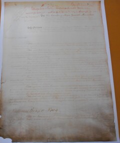
Document - 1856 PETITION COPY
Copy of petition from Sandhurst Crown Lands occupants to Major General Macarthur, Acting Governor of the colony of Victoria, seeking consideration for the improvements they had made on the lands they occupied under business licenses. Eighteen pages containing signatures, addresses and occupation of 1,387 storekeepers, publicans, miners, professionals and persons in various types of employment.bendigo, history, 1856 crown land occupants petition -
 Bacchus Marsh & District Historical Society
Map, Maddingley Township, Parish of Parwan, circa 1890s
Maddingley is a locality or township within the broader township area of Bacchus Marsh. This map is not dated. However features in Maddingley which appeared in the 1880s and 1890s are present in the map, These include the Bacchus Marsh Railway Station and the Bacchus Marsh Showgrounds. The main residential and commercial area of Maddingley is shown on this map in an area bounded by Bacchus Street, Barry Street, Griffith Street and Maddingley Road. Other streets visible are Franklin Street, Inglis Street, Labilliere Street, McCrae Street, Moore Street and part of Station Street.A single page paper map showing land allotments, streets, rivers, creeks, park lands, the railway line and Bacchus Marsh railway station in the township of Maddingley. The map is pasted into a bound volume containing 76 maps or plans in total. bacchus marsh victoria maps, maddingley victoria maps, land use, maddingley victoria history -
 Department of Energy, Environment and Climate Action
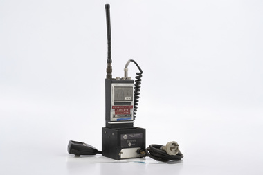
Motorola Syntax radio
After the 1939 bushfires, the Forests Commission Victoria invested heavily in a radically new communications network. After suffering some inevitable delays due to the war, radio VL3AA switched into full operation in October 1945 proudly beaming out 200 watts across the State. But by today’s standards, the technology was primitive and the reception poor unless the user was on a high point somewhere. The radio signal was "line-of-sight" and bounced between fire towers and relay transmitters across the mountains back to the District offices. The advent of solid-state electronics in the 1960s replaced the more delicate valve sets which enabled greater use of vehicle mounted radios. The Commission continued to research, develop and build new radios at its many workshops around Victoria. The network was supported by a large team of skilled radio technicians. The more secure and versatile State Mobile Radio (SMR) digital trunk system came into operation in about 1995. Upgraded Tait Radios were purchased in 2014 after recommendations of the 2009 Bushfires Royal Commission. But it was the convergence of separate technologies such as 5G mobile phones, high-capacity and light-weight lithium batteries, Wi-Fi, the ever-expanding internet, cloud data storage, digital cameras, GPS, personal organisers and hundreds of supporting Apps into powerful smartphones and tablets which revolutionised bushfire communications from the mid-2000s. Radio with handsetConservation Forests and Lands Colac Region 09/209bushfire, radios, forests commission victoria (fcv) -
 Department of Energy, Environment and Climate Action
Pye Portable radio and charger
After the 1939 bushfires, the Forests Commission Victoria invested heavily in a radically new communications network. After suffering some inevitable delays due to the war, radio VL3AA switched into full operation in October 1945 proudly beaming out 200 watts across the State. But by today’s standards, the technology was primitive and the reception poor unless the user was on a high point somewhere. The radio signal was "line-of-sight" and bounced between fire towers and relay transmitters across the mountains back to the District offices. The advent of solid-state electronics in the 1960s replaced the more delicate valve sets which enabled greater use of vehicle mounted radios. The Commission continued to research, develop and build new radios at its many workshops around Victoria. The network was supported by a large team of skilled radio technicians. The more secure and versatile State Mobile Radio (SMR) digital trunk system came into operation in about 1995. Upgraded Tait Radios were purchased in 2014 after recommendations of the 2009 Bushfires Royal Commission. But it was the convergence of separate technologies such as 5G mobile phones, high-capacity and light-weight lithium batteries, Wi-Fi, the ever-expanding internet, cloud data storage, digital cameras, GPS, personal organisers and hundreds of supporting Apps into powerful smartphones and tablets which revolutionised bushfire communications from the mid-2000s. Portable radio with handset and chargerConservation Forests and Lands Wangarattabushfire, radios, forests commission victoria (fcv) -
 Bendigo Historical Society Inc.
Document - 1856 PETITION OF CROWN LAND OCCUPANTS AT SANDHURST
Original petition from Sandhurst Crown Lands occupants to Major General Macarthur, Acting Governor of the colony of Victoria, seeking consideration for the improvements they had made on the lands they occupied under business licenses. Pages of document have been conserved, stored in individual pockets. Eighteen pages of parchment and paper containing signatures, addresses and occupation of 1,387 storekeepers, publicans, miners, professionals and persons in various types of employment. Cr. Alec Craig donated this item in 1959, to the Bendigo Historical Society.bendigo, history, 1856 crown land occupants petition, bendigo petition -
 Lakes Entrance Historical Society
Book, Tourist Development Authority of Victoria, Victorias 15 National Parks, 1956
This booklet contains a description of the 15 proclaimed Victorian National Parks as at 1956. Illustrated with photographic reproductions and locality map. Historically significant because of the time period.parks, natural history, crown lands, tourism -
 Merri-bek City Council
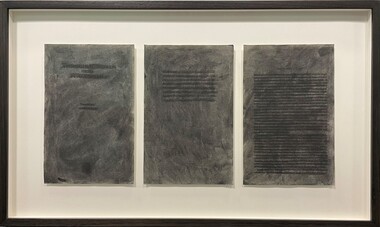
Work on paper - Charcoal and pages from Aboriginal Words and Place Names, Jenna Lee, Without us, 2022
Jenna Lee dissects and reconstructs colonial 'Indigenous dictionaries' and embeds the works with new cultural meaning. Long obsessed with the duality of the destructive and healing properties that fire can yield, this element has been applied to the paper in the forms of burning and mark-making. In Without Us, Lee uses charcoal to conceal the text on the page, viewing this process as a ritualistic act of reclaiming and honouring Indigenous heritage while challenging the oppressive legacies of colonialism. Lee explains in Art Guide (2022), ‘These books in particular [used to create the proposed works] are Aboriginal language dictionaries—but there’s no such thing as “Aboriginal language”. There are hundreds of languages. The dictionary just presents words, with no reference to where they came from. It was specifically published by collating compendiums from the 1920s, 30s and 40s, with the purpose to give [non-Indigenous] people pleasant sounding Aboriginal words to name children, houses and boats. And yet the first things that were taken from us was our language, children, land and water. And the reason our words were so widely written down was because [white Australians] were trying to eradicate us. They thought we were going extinct. The deeper you get into it, the darker it gets. But the purpose of my work is to take those horrible things and cast them as something beautiful.’Framed artwork -
Lakes Entrance Historical Society
Book, Andrew Claridge, Survey of Crown Lands, 1989
... Surveying A Preliminary Survey of Crown Lands between Lake ...A Preliminary Survey of Crown Lands between Lake Bunga and Mill Piont, Lake Tyers Beach Area Victoria.surveying -
Lakes Entrance Historical Society
Book, LERHS, Alfred William Howitt, 2018c
Compiled information on Alfred William Howitt Crown Lands Commissioner, Police Magistrate, Warden of the goldfields and coroner for the district of Omeo Victoria Victoriamines and mining, exploration, law -
Lakes Entrance Historical Society
Book, Department of Conservation Forests and Lands, Management Alternatives for Gippsland Lakes 1989, 1989
Provides information and inviting public comment and discussion on the management of the Gippsland Lakes Victoria.wetlands, recreation, waterways -
University of Melbourne, Burnley Campus Archives
Plan, Alton-Hascombe Feature Survey, c. 1990
1 tracing paper and 2 paper copies of plan by Department of Conservation, Forests and Lands, Division of Survey and Mapping, of adjoining gardens Alton and Hascombe at Mount Macedon, Victoria. Scale 1:1000. Plan of properties includes buildings, gardens and paddocks. 1 copy has significant buildings coloured.feature survey, mount macedon, gardens, alton, hascombe -
 Lakes Entrance Historical Society
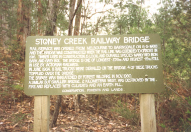
Photograph, Davies Judy, Stoney Creek Bridge Nowa Nowa Victoria, c1990
Colour photograpf of the sign erected by the Conservation, Forests and Lands Dept. at the Stoney Creek Bridge Nowa Nowa Victoria . Plus two other photos of the bridgebridges, forestry, tourism, topography -
 Stawell Historical Society Inc
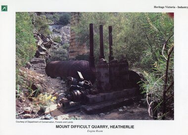
Photograph, Heatherlie Quarry -- Coloured
Coloured Photo Heatherlie QuarryColour Photograph of old engine and brick chimney surrounded by trees."Heritage Victoria - Industry" on top right. Unknown Logo on top Left. Courtesy of Department of Conservation, Forests and Lands. Mount Difficult Quarry, Heatherlie Engine Room On reverse information about Mount Difficult Quarry, Heatherlie, including two photgraphs.stawell grampians industry -
Clunes Museum
Plan - TITLE PLAN, DEPARTMENT OF LANDS AND SURVEY, TOWNSHIP OF GLENGOWER
... DRAWN AND REPRODUCED AT THE DEPT. OF LANDS AND SURVERY... AND REPRODUCED AT THE DEPT. OF LANDS AND SURVERY MELBOURNE VICTORIA ...1 PAGE PLAN OF THE TOWNSHIP OF GLENGOWER COUNTY OF TALBOT (11 COPIES) DRAWN AND REPRODUCED AT THE DEPT. OF LANDS AND SURVERY MELBOURNE VICTORIA NOVEMBER 1954 PRICE 2/-parish of glengower, title plan of glengower -
Clunes Museum
Map - MAPS, A.C. BROOKS GOVERNMENT PRINTER MELBOURNE
.1 PARISH OF CLUNES, COUNTY OF TALBOT. (3 COPIES) (1) STAMP: DRAWING OFFICE RECORDS COPY, STATE ELECTRICITY COMMISSION OF VICTORIA. ELECTRICITY DEPARTMENT (THIS PLAN MUST NOT BE TAKEN FOR FIELD USE. PLEASE DO NOT DEFACE) C71 ON LEFT BOTTOM CORNER, CLUNES SHEET 1 (2) '19' HANDWRITTEN ON ALL FOUR CORNERS AND PLASTIC TAB FOR HANGING (3) PLASTIC TAB FOR HANGING .2 MAP BECKWORTH COUNTY OF TALBOT (3 COPIES) (1) IN RED: B-61. L.4855. THE ALLOTMENTS COLOURED BROWN ARE FREEHOLD (2) WITH PLASTIC TAB FOR HANGING (3) WITH PLASTIC TAB FOR HANGING. '14' HAND WRITTEN IN ALL 4 CORNERS AND VARIOUS PENCIL NOTATIONS ON THE MAP..1.2 DRAWN AND REPRODUCED AT THE DEPARTMENT OF LANDS & SURVEY MELBOURNE. PRICE 2/- .1 IN PENCIL ON BOTTOM ' 211 ' 20%parish of clunes, electricity supply department, beckworth -
 Wooragee Landcare Group
Photograph, 3rd April 2004
This photograph depicts fox behaviour specialist Camille Veselsky demonstrating the use of a fox bait trap at an event conducted as part of an awareness campaign highlighting damage done to farm and domestic animals and native wildlife in April 2004. Camille Veselsky is a specialist in fox behaviour who worked for the Hume Rural lands Protection Board on pest animal control for 27 years. This date is suggested by the photograph's position in the 2004-2005 Wooragee Landcare Group Coordinator's Report folder. A note accompanying the item suggests an alternative date of February 2004, however. This event raised awareness about the impacts of foxes in rural areas and provided practical training in techniques to control their populations. Flyers contained in the parent folder suggest that baiting may have been agreed as a method of fox control as the event depicted was followed by a two week baiting campaign a fortnight later. Pictured in the photograph are Helmut Wiemann, Ursula Wiemann, Camille Veselsky and two other people (unknown). A note accompanying the items suggests the photograph may have been entered by Karen Bowley or Maree Missen. In the folder, an printed label accompanying the photograph states: 'A marker to identify the bait station will not deter the fox.' Regional areas like Wooragee are susceptible to fox attacks due to the availability of food such as rubbish, scraps, native wildlife and livestock. Foxes can have a huge impact on native wildlife and domestic life as they are known to chew through irrigation systems, dig-up and defecate in gardens, raid rubbish bins and harass other domestic animals. Ground-dwelling native species are particularly susceptible to predation by foxes, which when combined with loss of habitat can endanger these species. Affected species include Speckled Warblers, Plovers, Diamond Firetails, Spotted Quail-Thrushes, Turquoise Parrots, Dunnarts, Bandicoots, Phascogales, skinks, geckos and legless lizards. This photograph is significant as an example of awareness raising and threat control programs undertaken by Wooragee Landcare Group in the 2000s in Indigo Shire.Landscape coloured photograph printed on gloss paper. Reverse: 26 / [HANDWRITTEN] WAN NA 0ANA2N0 0 8743 / [PRINTED] (No. 14) / 260 / wooragee, wooragee landcare, indigo shire, north-east victoria, conservation, pest control, fox, foxes, vermin, baiting, trapping, camille veselsky, hume rural lands protection board, 2004, speckled warbler, plovers, diamond firetails, turquoise parrots, dunnarts, bandicoots, phascogales, skinks, geckos, legless lizards, chickens, ducks, guinea-pigs -
 Bendigo Historical Society Inc.
Map - PLAN GENERAL SURVEY MALMSBURY PORCUPINE INN, FOREST CREEK TO GOLDEN POINT. ALEXANDRA RANGE 1853
Colour Copy of Plan of the General Survey from the Town of Malmsbury to the Porcupine Inn, from the sources of Forest Creek to Golden Point, shewing (sic) the Alexandrian Range also Sawpit Gully Bendigo and Bullock Creeks. Handwritten note under the title a follows '' Forwarded to the Colonial Secretary with my letter No A 53/105 dated 30th March 1853 for transmission to the Geological Surveyor. R Hoddle Surveyor General. ' Stamped by Department of Mines Victoria with record#123 in Top right Hand corner. Also contains a catalogue number 2053/M/2. Part of the Contents of a DVD entitled 'Mapping Great Change' - Archival Maps, produced to support an exhibition in the Post Office Gallery Bendigo. A description of the Map, its history and implications for both historical and future discussions is contained in an Essay 'Mapping Great Changes' : The landscape of central Victoria by Gerry Gill.R. Hoddlemap, bendigo, country lands -
 University of Melbourne, Burnley Campus Archives
Plan, Plan of Richmond Park, 1886-1948
(1) Black and white photographed copy of an original coloured plan. Plan of Richmond Park with Horticultural Society Gardens marked in. Includes additional land which became the Field Station. Original plan dated 31 August 1872, note of Crown Grant to the Board of Land & Works and Richmond City Council 1886; showing land, "Permanently Preserved for the Gardens". Stamp, "Department of Lands and Survey Photographed at the Central Plan Office 1/1 Plate 7.12.48" (2) Also 2 photocopies, 1 reduced - possibly used in a publication1 photocopy has "Figure 1. Plan of Burnley Gardens circa 1863 [sic]gardens, richmond, horticultural society of victoria, richmond park, a.l. martin